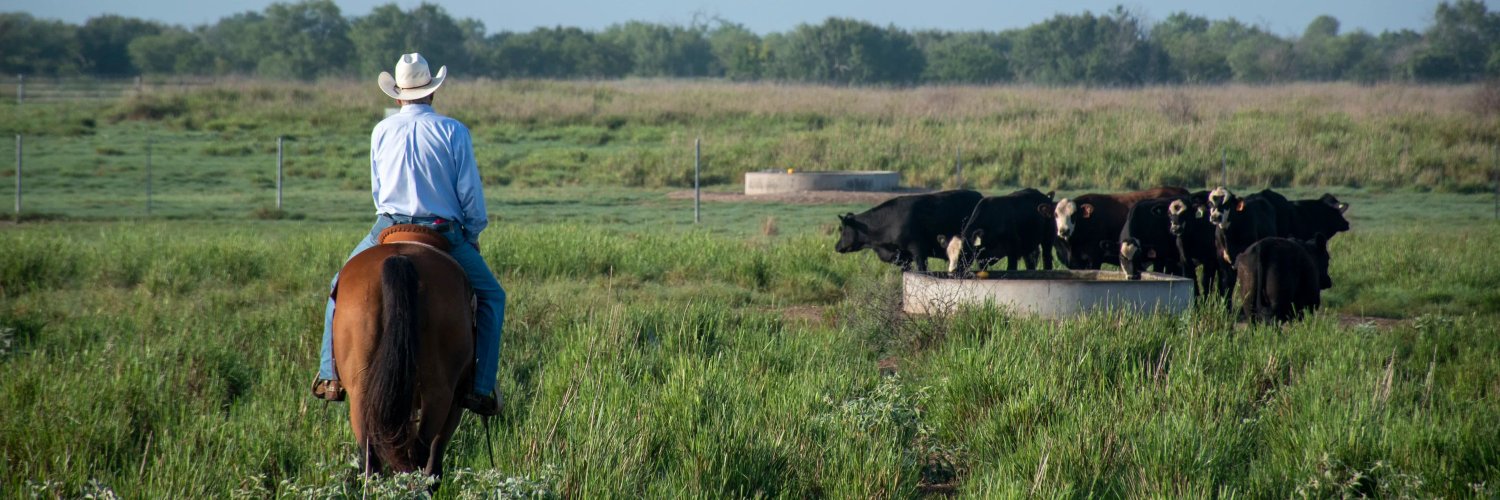
The definitive voice of U.S. cattle & beef producers since 1898. Fighting to keep our industry profitable, sustainable, and strong for generations to come.
This week's weather features severe storms and flooding.
Areas to watch:
📍 Northern Plains – severe thunderstorms
📍 North Dakota – heavy rain and flooding
📍 West Texas & New Mexico – flash flood concerns
📍 Great Lakes & Northeast – weekend storm chances
📍 Eastern U.S. – growing heat and humidity
📍 Southwestern U.S. – watch the moisture from a tropical wave developing near Mexico
📍 Hawai'i – Watch for the tropical wave developing southwest of Baja
@MattMakens covers all the highlights in a weekly update he sends out. The Weekly Weather Watch is available to NCBA members for free. Sign up here: https://t.co/98tjOqZGC8
#WeatherUpdate #WeeklyWeatherWatch
A stormy and active weather pattern is expected across much of the U.S. from May 31 through June 7.
🌧️ South & Southeast:
Daily rounds of heavy rain and thunderstorms are likely from the Gulf Coast into Florida and parts of the Southeast. Slow-moving storms may lead to localized flash flooding, especially in flood-prone areas. Areas of Alabama, Georgia and Florida could see repeated rainfall through next week.
🏔️ Northern Rockies:
Montana and northern Wyoming may experience widespread heavy rain and even some mountain snow early in the period as a strong upper-level low settles over the region.
⛈️ Plains:
Storm chances increase later next week as the western system shifts east into the Plains.
🔥 Heat Concerns:
Extreme heat may develop first across California’s Central Valley and the Desert Southwest around June 4, then expand into parts of the Plains, Mississippi Valley, Ohio Valley and western Great Lakes by next weekend.
💨 California Coast:
Periods of gusty winds are possible along parts of coastal California late next week.
📍 Main concerns through the period:
• Heavy rain & flash flooding in the Southeast
• Heavy rain/mountain snow in the northern Rockies
• Expanding heat risk across the central U.S. later next week
• Increasing storm chances in the Plains
@MattMakens
We know many, if not most, of our producers are battling drought conditions. There was some recent moisture that improved the pastures and grass health during the past couple of weeks. Although roughly similar to the popular drought monitor product, the two images here represent the health of vegetation currently (on the left, oranges/reds indicate poor plant health relative to what it would normally be this week) and how the health has changed in the past couple of weeks (on the right, browns indicate where plant health has gotten more stressed versus the teals representing areas of some improved health).
NOAA/NESDIS products like these, visualized for us by @mattmakens, are useful for seeing short-term gains from recent precipitation in areas that remain covered by a drought monitor classification. Case in point: in the past week or so, many pockets of grass improved across the West, in localized areas of Colorado and Wyoming, southeastern Oklahoma, southern and central Texas, and southern Florida. Those same areas remain in at least D2 drought, so they are certainly not out of the woods from a long-term drought perspective, but at least they got a short-term boost.
The big picture remains, however: many of our producers are in regions with very poor grass/forage health due to drought. Although El Niño is likely to bring relief to many later this year, the change won't be immediate and takes time to transition, as discussed in the recent National Cattlemen's Newspapers.
There is A LOT of El Niño discussion happening right now. Although “Super” isn’t an official term, the potential for becoming one of the strongest events on record has been dubbed the “Super El Niño” buzz. The problem is that the atmosphere has yet to “couple” with the warming ocean conditions in order to create an El Niño pattern as of now, but that may shift in the coming weeks.
Get the breakdown from @MattMakens here: https://t.co/P6nee9KkAI
Listen or watch the latest Cattlemen's Call podcast now!🎧
🔗 https://t.co/2kl0eFSpZ6
Greg Putnam of @LBCC2020 served as a Navy SEAL and upon retiring, co-founded the ranch in Montana as a first-generation producer new to ag.
Today, Little Belt Cattle Co. collaborates with other businesses and ranchers to expand local beef access to consumers and offering greater opportunities for #veterans who want to get into #agriculture.
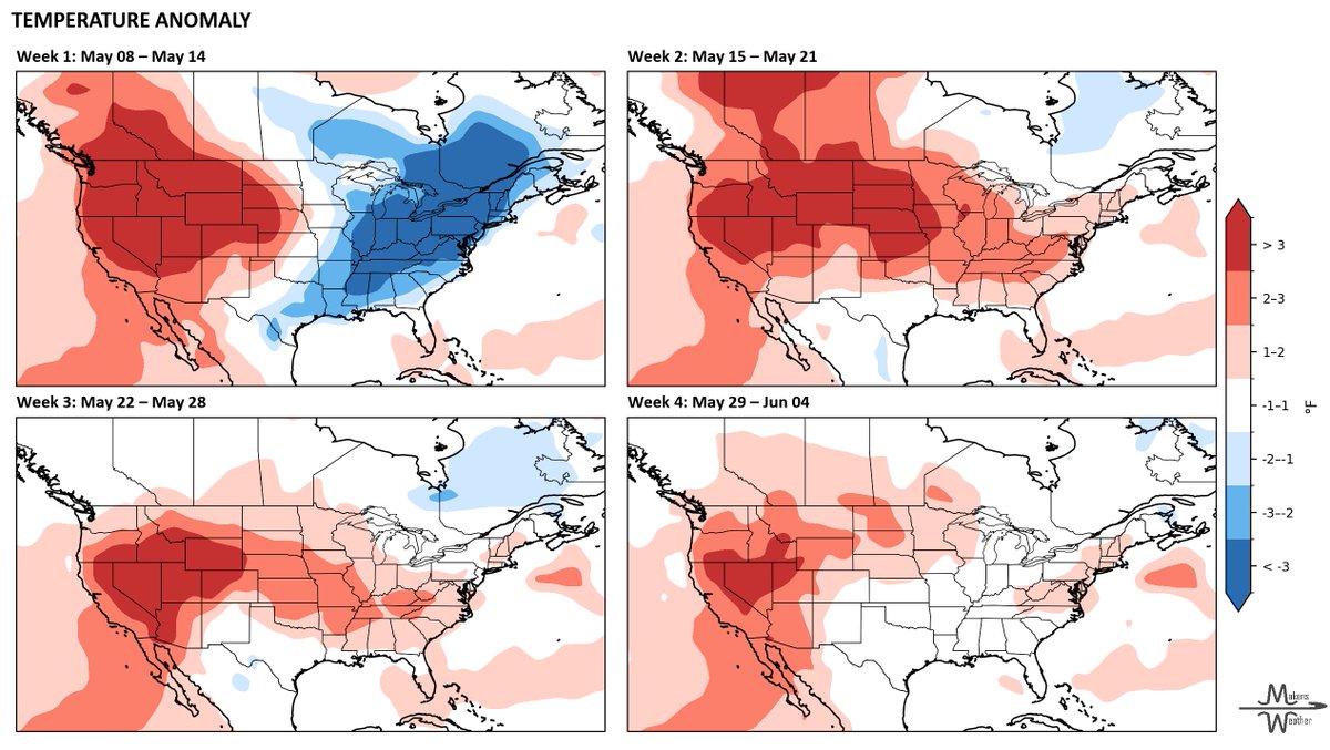
Big weather swings are ahead for the next month. 🌩️➡️☀️➡️🌧️
The next 7–10 days start active with severe storms, heavy rain, flooding concerns and even frost risk in parts of the northern Plains and Upper Midwest. Producers from Texas to the Mississippi Valley should stay alert for hail, damaging winds and localized flooding this weekend.
By mid-May, much of the Plains turn warmer and drier, helping fieldwork progress but increasing stress on topsoil moisture, livestock and fire weather concerns — especially across the western Plains and Canadian Prairies.
As we head toward late May, moisture chances begin rebuilding from the south, with wetter signals increasing for Texas, Oklahoma and parts of the central U.S. Severe weather will likely remain part of the pattern wherever warm, humid air collides with incoming systems.
Bottom line: Expect a rollercoaster pattern with rapid shifts between stormy, dry, warm and wet conditions through early June. Stay flexible and keep an eye on short-range forecasts as conditions evolve.
@MattMakens
The most extensive pasture weed control available.
🛡️ Control 140+ broadleaf weeds
⏳Extended residual control to stop weeds that emerge later
🌱More usable forage to support pounds per acre
DuraCor® herbicide delivers broad‑spectrum, long‑lasting pasture weed control—helping you get more productivity from every grazing acre.
👉 Learn more here: https://t.co/aWxyiYptD5
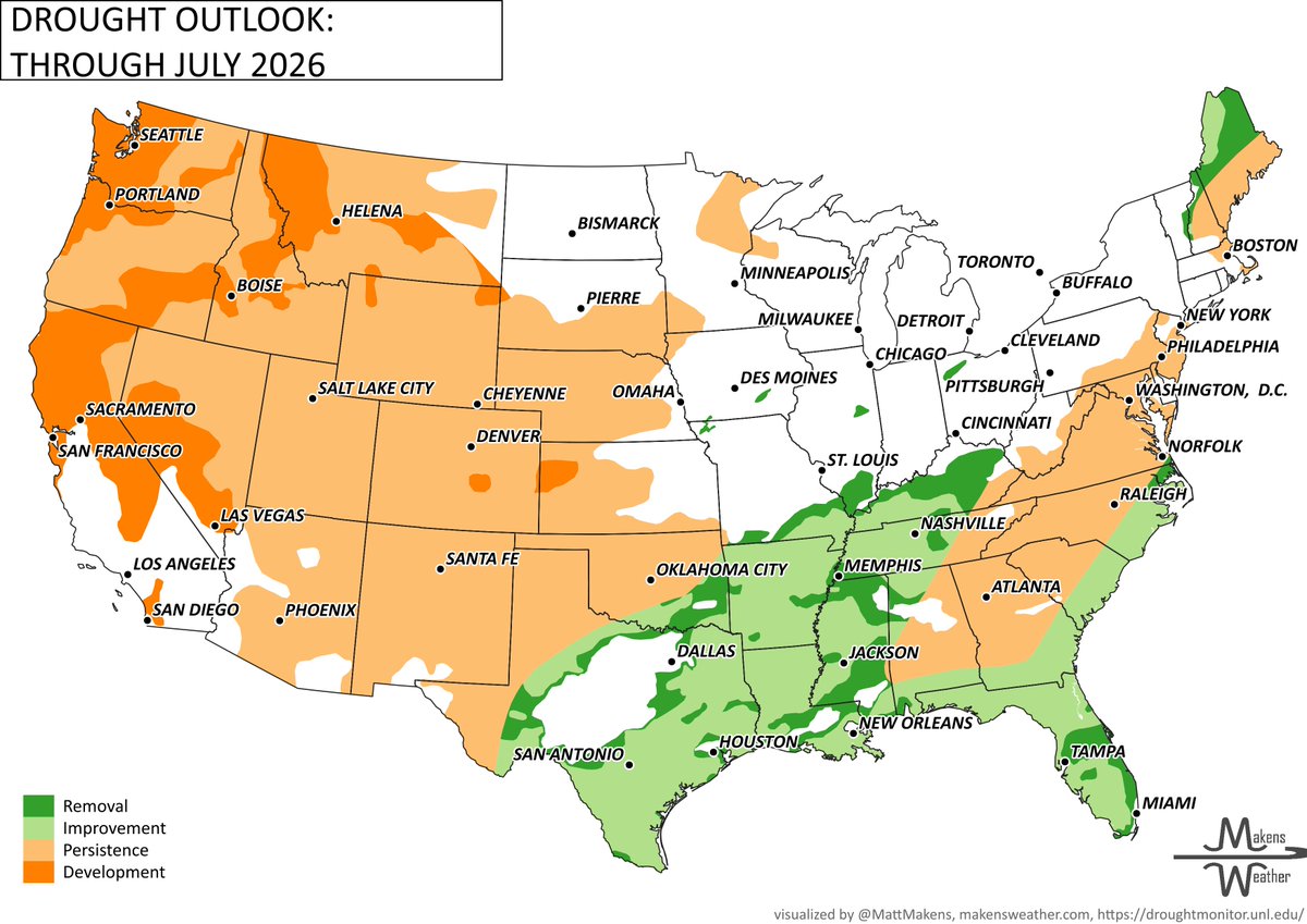
You've heard El Niño is developing but don't expect an overnight fix. El Niño's strongest influence tends to come during the winter/cold season, leaving late spring through summer subject to other drivers.
That said, the drought outlook through July from @MattMakens does show some encouraging signs for southern producers, with drought improvement and even removal expected across parts of Texas, the Gulf Coast, and the Southeast. The West, however, tells a different story — drought persistence and development dominate from California through the Rockies.
Even if drought improves in those highlighted areas during the next couple of months, July and August are projected to turn dry again — meaning patience is key. El Niño's classically wet pattern for the Southern U.S. won't be an immediate or sustained fix. Relief, where it comes, won't be uniform.
Grateful to @BeefUSA for the opportunity to speak with American cattle producers and ranchers last week.
The message was loud and clear: @POTUS and Republicans’ Working Families Tax Cuts eases tax burdens for hardworking farm and ranch families, helping them keep more of their hard-earned income, invest in their operations, and preserve their family farms.
U.S. Drought Update & May Outlook: A Transition Pattern with Uneven Impacts
Recent conditions highlight a growing divide in moisture trends across the U.S.
Over the past week, a corridor from Texas through the Midwest into the Great Lakes received well above-normal precipitation — locally exceeding 300–400% of typical amounts. These rains led to targeted improvements in drought conditions, particularly across portions of Oklahoma, Texas and parts of the Midwest.
However, outside of this corridor, conditions continue to deteriorate.
Southeast: Widespread degradation persists, with expansion of severe to exceptional drought across Georgia, the Carolinas, Alabama and Florida. Agricultural impacts are becoming increasingly evident.
Central Plains & High Plains: Warm and dry conditions have supported further expansion of moderate to extreme drought, particularly in Nebraska, Kansas and eastern Colorado.
West: While precipitation was mixed, overall dryness and early snowpack melt are raising concerns about seasonal water availability.
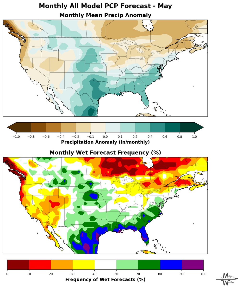
May Outlook: Warmer Pattern with Regional Precipitation Uncertainty
Looking ahead, the May outlook points to a broadly warmer-than-normal pattern across much of the West., Great Plains and Southeast.
Temperature: The strongest probabilities for above-normal temperatures are across the Pacific Northwest and northern tier.
Precipitation: Increased chances for above-normal precipitation from Texas into the Lower Mississippi Valley. Drier tendencies favored across the Pacific Northwest and parts of the Great Basin. Much of the central and eastern U.S. remains in a section of lower predictability, typical of late spring convective patterns.
@MattMakens says he's watching large-scale drivers, including a strengthening Madden-Julian Oscillation and emerging El Niño conditions, that may contribute to variability throughout the month, particularly across the central and eastern U.S.
Matt's Key Takeaways:
While recent rainfall has provided localized drought relief, broader trends remain concerning. Drought expansion continues across key agricultural regions, and May is expected to bring a variable pattern with continued regional disparities in both temperature and precipitation.
NCBA and its nationwide network of state affiliates gathered in our nation’s capital this week for NCBA’s 2026 Legislative Conference.
Producers met with their Members of Congress, connected with House Ag Committee Chairman @CongressmanGT, and heard from federal agency representatives and U.S. @TreasurerBeach. Cattle producers used their voices to drive real progress for the beef cattle industry.
🌍 Is a "Super El Niño" on the Horizon?
The gossip is over: La Niña has officially left the building, and El Niño is taking center stage. But this isn't just any weather shift; media buzz has already raised the hype about the potential for a “Super El Niño” that could redefine the agricultural landscape for the year ahead.
What’s the Big Deal?
While a typical El Niño can bring much-needed moisture to the beef industry, a "Super" event (sea surface temperatures peaking at +2.0°C or higher) acts as a risk multiplier.
Here is what the data is telling us right now:
• The Forecast: Current models indicate a moderate-to-strong event is likely, with about a 25% chance of reaching "Super" status.
• The "Super" Impact: These rare, extreme events, like those in 1982, 1997, and 2015, amplify global weather patterns, leading to more pronounced flooding, droughts and temperature swings.
• Timing: While we’ll see variability this summer, the strongest influence typically hits from fall through spring, peaking in early 2027.
What to Watch This Summer (June–August 2026)
• The Southwest/Rockies: A strengthening North American Monsoon could bring increased moisture from Arizona up through Wyoming.
• The Corn Belt & Gulf Coast: By contrast, data suggest continued drought in parts of Texas, the Gulf Coast and the Upper Midwest.
• Pacific Northwest: High confidence (>80% chance) for a dry summer.
Bottom Line for Producers
Whether this event turns "Super" or stays moderate, it’s time to start thinking ahead. Watch hay prices and evaluate stocking rates as we move toward fall. No, the weather we will have the rest of April and May is not related to El Niño – that impact comes later this year.
📊 Want to dive deeper? @MattMakens is working on content for you in an article you will see in May’s National Cattlemen.
#AgWeather #ElNino #CattleIndustry #FarmLife #ClimateOutlook #SuperElNino #Meteorology
We could not have said it any better @SpeakerJohnson! NCBA thanks the Speaker and Congress for standing with American cattle producers and delivering real tax relief to rural America.
NCBA and the Iowa Cattlemen’s Association joined @SpeakerJohnson at a Tax Day press conference to discuss provisions included in the Working Families Tax Cuts. The legislation provides additional clarity and predictability during tax season for cattle producers. This tax package supports farm and ranching families and helps create conditions for future generations to continue feeding America.
During the @USTreasury tax roundtable @TreasurerBeach talked with cattle producers on his goal to strengthen of rural economies and expanding the Death Tax exemption is one of the most effective ways to accomplish it.
NCBA joined a tax and credit roundtable hosted by @USTreasury discussing administering the tax provisions in the Working Families Tax Cuts Act and how beneficial it is for family-owned farms and ranches.
This week's Drought Monitor, and it comes with some historic context.
March 2026 was the warmest March on record for the contiguous U.S., 9.4°F above the 20th-century average. January through March was the driest on record, breaking a mark set in 1910.
On the map this week:
➡️ Washington state issued a statewide emergency drought declaration
➡️ Colorado snowpack at lowest on record — peak SWE occurred March 8, a full MONTH early
➡️ D4 Exceptional Drought expanded across southern Georgia and northern Florida
➡️ Midwest got significant relief — multiple locations had their wettest 30-day period on record
The drought picture is getting more serious before it gets better. The spring outlook from the latest global modeling suite updated on April 10.
Temperature: Above-normal favored across most of the drought-affected regions through April–June.
Precipitation: Mixed signals — some potential relief for the southern Plains, but the West and Southeast outlook remains dry-leaning.
What are you seeing on the ground this week?
🌱 25% can change everything.
White clover in cool-season pastures has been shown to improve cattle conception rates by up to 25%.
With NovaGraz™ herbicide, you can control tough broadleaf weeds without sacrificing the white clover that helps drive herd performance.
Protect what matters.
Find out how here: https://t.co/zN0MnHHro0
@cortevapastures #ByTheNumbers #WhiteClover #PastureManagement
A high-impact, multi-hazard stretch of weather is underway late this week into the weekend, starting with a dangerous mix of severe storms and winter weather. Here is a timeline of the activity.
Late this week (Thursday-Saturday):
A powerful system brings severe thunderstorms to the Upper/Middle Mississippi Valley Thursday into Friday, with damaging winds, hail and a few tornadoes possible. Storms spread into the Ohio Valley and parts of the South by Saturday.
At the same time, a major winter storm is unfolding to the north with heavy snow, sleet and ice from the Northern Plains into the Upper Midwest and Great Lakes. Travel could become very difficult, especially where ice accumulates, and power outages are possible. A second round of snow and icing follows Friday into Saturday, prolonging impacts.
Sunday into next week:
The pattern shifts east, bringing widespread rain and thunderstorms along the East Coast and Gulf Coast Sunday. While fast-moving, South Texas could see repeated storms, and Florida stays wet into midweek.
Behind the system, cooler air spreads across much of the central and eastern U.S., with some lingering rain and snow around the Great Lakes and Northeast early next week.
Meanwhile, the West sees a brief warmup before rain and mountain snow return by midweek.
@MattMakens