Due to the Thunderstorms that passed last night (rare in November, when we typically average less than 1 T-storm day) we've now seen the wettest year on record at Pearson Airport (back to 1938), with a month and a half still to go. 🌧️
On top of the severe weather that occurred last night in southern Ontario (https://t.co/IOyNwTtySI…), Toronto Airport recorded enough rain to make it the wettest year on record. #onstorm#ONwx#Toronto
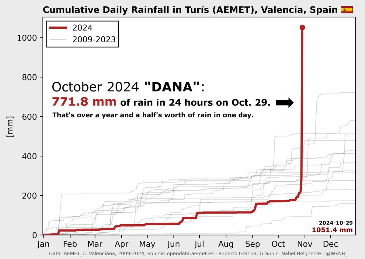
This is quite an eye-opening spaghetti plot of the annual precipitation in Valencia (all the grey lines represent past years). Look at that vertical line for this year - 30+ inches (771mm) of rain in 24 hours. Terrifying for water managers.
This is probably the most astonishing rainfall data I’ve ever had my hands on. Turis, Valencia, Spain, found itself in the absolute worst of last week’s extreme rain event. The town ended up with a mind-boggling 771.8 mm (30.4 inches) of rainfall over the course of 24 hours.
@jdavey_2 The satellite products are out of this world - its basically half of the entire City of Hamilton's jurisdiction impacted (561km^2 vs 1138km^2) - Unfathomable (but clearly, not impossible).
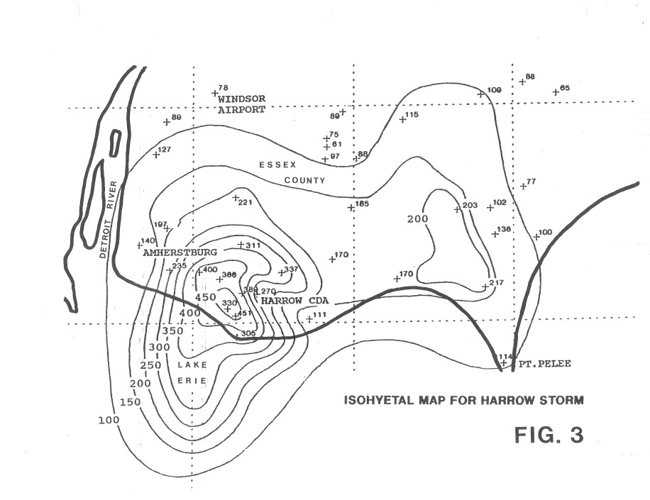
@jdavey_2 To give you an idea of just how insane that is, that amount has only happened once in Ontario for the period we have records for - the Harrow (Essex) Storm of July 1989. None of our infrastructure is designed to cope with anything remotely close to that.
@jdavey_2 It's from the original estimates that JP Bruce did for the Department of Planning & Development back in the late 1950s - its gone up a little since then (18.4" is ~467mm) with future studies & newer methods (including maximum persisting dew points and other very nerdy stuff).
@jdavey_2 It would definitely be dependent on the major storm producing processes that the land mass in question can be subject to - so for example, this is (an old) version of the one for southern Ontario, where the two biggies are Tropical Storms (solid) and Thunderstorms (dotted line)
@jdavey_2 For further context, the 48h Probable Maximum Precipitation (PMP) for southern Ontario has been estimated between 450 and 500mm - which is basically "how bad theoretically could it get" - would be interesting to compare what France received with its PMP estimates.
This will be a very cool initiative to be a part of! If our experience has taught me anything, a live-feed camera of the creek would be a great public interest piece.
‘Environmental science happening in real time’: New McMaster University lab is in Ancaster’s backyard
👉 https://t.co/16csM01eGb
School field trips & initiatives geared toward public, including accessible walking trail with views of ongoing projects in area, are on horizon
@jdavey_2 Did you see this new study in Nature as well? We are historically undercounting deaths by Tropical Storms by.....a lot https://t.co/AZls1bIga4
@jdavey_2 I saw the same one, yeah. I also saw one that said there has been 3 hurricanes make landfall in Taylor County Florida in the past 13 months. Which is a sobering stat.
@EasyThePianoMan@cycletherapyHam @MsMelcochita @HamiltonRambler They have so many options, cool! Honestly, I think this is the way to capture whatever the equivalent of EV range anxiety is for cyclists, retrofits to an existing bicycle. 🚴♂️🚴♀️
@jdavey_2 I was on flood duty all week so I was watching it very closely - very fortunate for us that low blocked it, and it didn't come up here, run into a front and re-intensify/stall like Hazel did.
The rainfall totals in the NC mountains from Helene are mind blowing - 29.58" (751mm) in 48 hours 😱(for reference, Hurricane Hazel was 11.2" (285mm) in 48 hours, just catastrophic stuff https://t.co/AN7grxyTKG
@jdavey_2 I worked for a Prof at UWO in the summer of 2009 and went for multiple week-long cruises on Lake Erie aboard the CCGS Limnos (one of their science vessels) and it was already identified as a problem back then - we haven't made a lot of progress in the 15 years since...
I know folks are doing chili, pumpkin, and apple picking so I don't want to ruin the mood, but... the nearby counties in NY state show a 3°F rise in average fall temp from 1970-2023 https://t.co/eNdREo5C9i
@jdavey_2 The CHCH article included this "Large rocks had been placed in front of the restaurant and park entrance years ago due to ongoing safety concerns and car accidents." 😬 I drive by it all the time and don't remember an accident like this. Tragic stuff.
@dlind_ham@jdavey_2 I'd echo Dave - when we get it at our reservoirs, it can be more pronounced near the outflow structures, so you'd probably see more of it near the main embankment off Harrison Road. To say nothing of the prevailing winds blowing in that direction too.