📢 Cyprus Earth Observation Data Cube towards water resource management in the context of climate crisis by Stelios P. Neophytides, Gregory Giuliani @greggiuliani, Charalampos Kontoes, Diofantos G. Hadjimitsis & Michalis Mavrovouniotis
👉Article link: https://t.co/nv6zTlS6GG
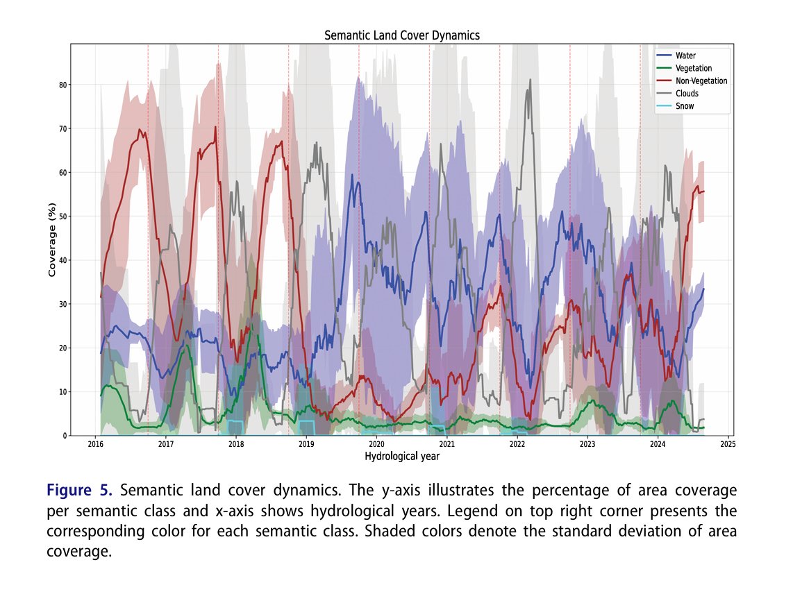
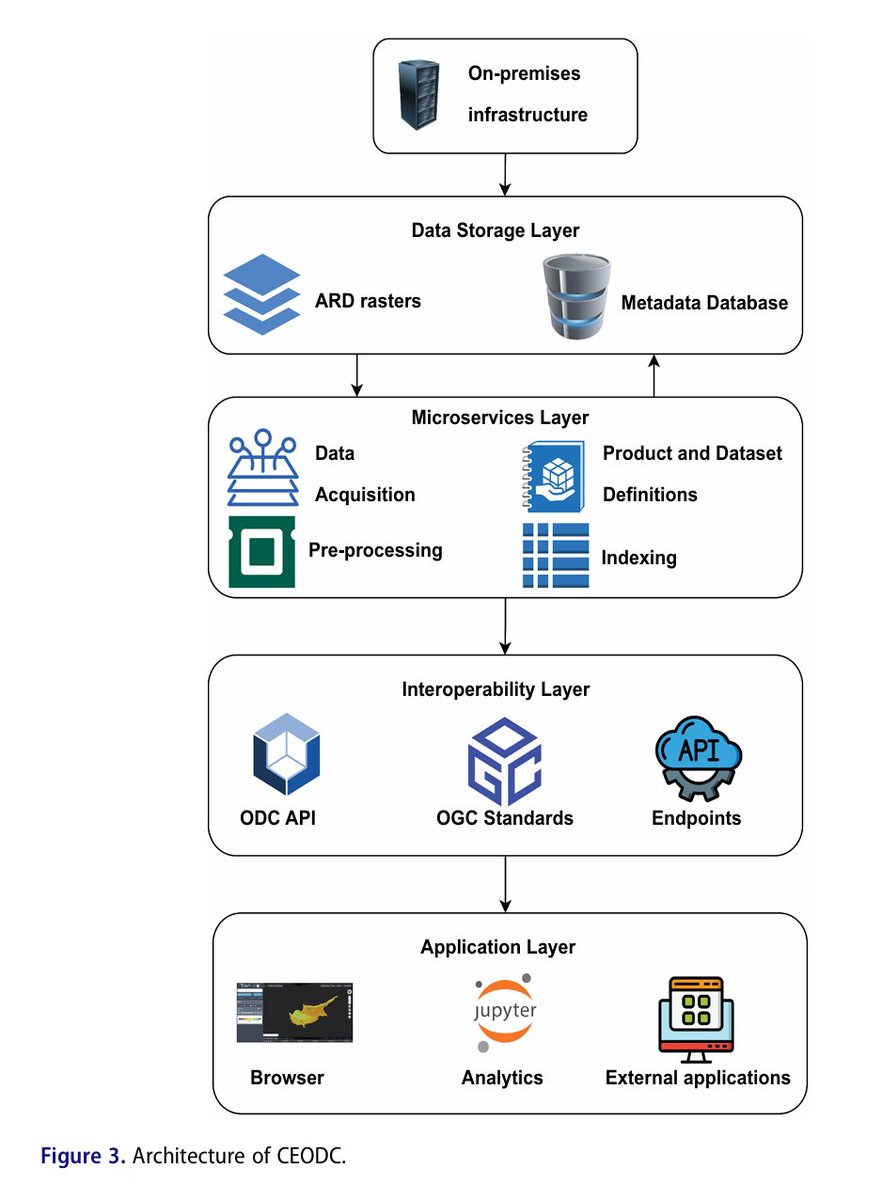
💌The amount of Earth observation data is getting larger day by day. This rapid evolution of the field and the exponential growth of data generation mediums urges the need for modern ways of fast analysis and processing of satellite images. Earth Observation Data Cubes enhance the way Earth data are distributed, handled, stored, and analyzed by providers and users. In this study the development of the National Earth Observation Data Cube of #Cyprus is described and the importance of such software-based #infrastructure is demonstrated through a #water resource monitoring use case in the context of climate crisis in the #Mediterranean region. Moreover, this study exhibits the capabilities of #semantic classification in Earth observation, introducing a spatially generalized approach for easier environmental monitoring. Such developments can enhance the preservation of the #environment and its protection from future natural and human disasters. An online platform has been developed and welcomes users to access the #CEODC ecosystem at https://t.co/Vsk2Z2kkQ0, while all tools and services are also integrated within the #ERATOSTHENES Regional Exploitation Platform: https://t.co/yWlINf3sB7.
#bigearthdata #digitalearth #geoscience #remotesensing #earthobservation #GIS #datacube #ClimateChange #AI #waterresource #disaster
📢 Cyprus Earth Observation Data Cube towards water resource management in the context of climate crisis by Stelios P. Neophytides, Gregory Giuliani @greggiuliani, Charalampos Kontoes, Diofantos G. Hadjimitsis & Michalis Mavrovouniotis
👉Article link: https://t.co/nv6zTlS6GG
💌The amount of Earth observation data is getting larger day by day. This rapid evolution of the field and the exponential growth of data generation mediums urges the need for modern ways of fast analysis and processing of satellite images. Earth Observation Data Cubes enhance the way Earth data are distributed, handled, stored, and analyzed by providers and users. In this study the development of the National Earth Observation Data Cube of #Cyprus is described and the importance of such software-based #infrastructure is demonstrated through a #water resource monitoring use case in the context of climate crisis in the #Mediterranean region. Moreover, this study exhibits the capabilities of #semantic classification in Earth observation, introducing a spatially generalized approach for easier environmental monitoring. Such developments can enhance the preservation of the #environment and its protection from future natural and human disasters. An online platform has been developed and welcomes users to access the #CEODC ecosystem at https://t.co/Vsk2Z2kkQ0, while all tools and services are also integrated within the #ERATOSTHENES Regional Exploitation Platform: https://t.co/yWlINf3sB7.
#bigearthdata #digitalearth #geoscience #remotesensing #earthobservation #GIS #datacube #ClimateChange #AI #waterresource #disaster
📢 A digital twin approach for the identification and update of ecological infrastructure by Audrey Lambiel, Gregory Giuliani @greggiuliani, Nathan Külling& Anthony Lehmann
👉https://t.co/86fAymC0Z7
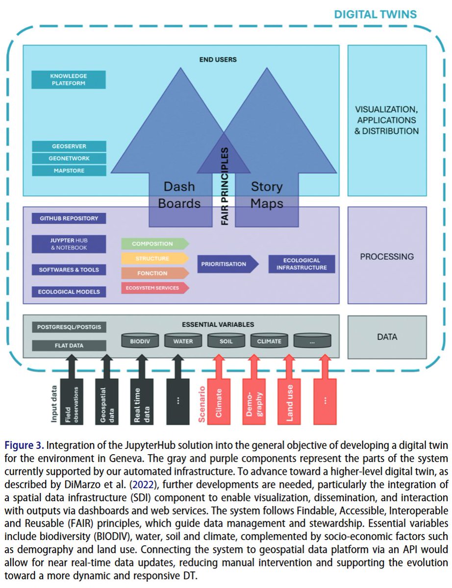
💌Addressing the global environmental crisis necessitates coordinated efforts, supported by open and #reproducibleresearch practices. Such practices aim to enhance the reliability, efficiency, and credibility of scientific outputs. Innovative tools are necessary for systematic conservation planning. This technical note presents a reproducible and automated approach for supporting #landmanagement and planning by identifying and updating ecological #infrastructure (EI). Grounded in #openscienceFindable, Accessible, Interoperable, and Reusable principles #datamanagement, and #digitaltwin (DT) concepts, the method focuses on the Canton of #Geneva, #Switzerland. It integrates species distribution modelling, #ecosystemservice assessments, and spatial prioritization within a shared #JupyterLabenvironment. The infrastructure centralizes data, automates indicator calculations, and ensures transparency, traceability, and reproducibility through version control and metadata generation. Ecological tools like #Zonationenable the identification of high-priority #conservation areas aligned with international targets. The system facilitates collaborative #workflowsand indicator updates. Its architecture allows scalability to broader regions and scenario modelling, laying the foundation for a DT of Geneva’s environment. Despite challenges in harmonizing workflows across institutional partners, this solution enhances efficiency and replicability in EI planning. The methodology is transferable to other regions and adaptable to various environmental modelling domains, offering a robust base for sustainable territorial management. All scripts needed for the process are stored and described in a #GitHubrepository: https://t.co/pX0oNe4xUf.
#Ecologicalinfrastructure #ecosystemservices #spatialanalysis #biodiversity #bigearthdata #digitalearth #geoscience #remotesensing #earthobservation #GIS #dataanalysis #BigData #FAIR #SpatialDataInfrastructure #SDI
📢 A digital twin approach for the identification and update of ecological infrastructure by Audrey Lambiel, Gregory Giuliani @greggiuliani, Nathan Külling& Anthony Lehmann
👉https://t.co/86fAymC0Z7
💌Addressing the global environmental crisis necessitates coordinated efforts, supported by open and #reproducibleresearch practices. Such practices aim to enhance the reliability, efficiency, and credibility of scientific outputs. Innovative tools are necessary for systematic conservation planning. This technical note presents a reproducible and automated approach for supporting #landmanagement and planning by identifying and updating ecological #infrastructure (EI). Grounded in #openscienceFindable, Accessible, Interoperable, and Reusable principles #datamanagement, and #digitaltwin (DT) concepts, the method focuses on the Canton of #Geneva, #Switzerland. It integrates species distribution modelling, #ecosystemservice assessments, and spatial prioritization within a shared #JupyterLabenvironment. The infrastructure centralizes data, automates indicator calculations, and ensures transparency, traceability, and reproducibility through version control and metadata generation. Ecological tools like #Zonationenable the identification of high-priority #conservation areas aligned with international targets. The system facilitates collaborative #workflowsand indicator updates. Its architecture allows scalability to broader regions and scenario modelling, laying the foundation for a DT of Geneva’s environment. Despite challenges in harmonizing workflows across institutional partners, this solution enhances efficiency and replicability in EI planning. The methodology is transferable to other regions and adaptable to various environmental modelling domains, offering a robust base for sustainable territorial management. All scripts needed for the process are stored and described in a #GitHubrepository: https://t.co/pX0oNe4xUf.
#Ecologicalinfrastructure #ecosystemservices #spatialanalysis #biodiversity #bigearthdata #digitalearth #geoscience #remotesensing #earthobservation #GIS #dataanalysis #BigData #FAIR #SpatialDataInfrastructure #SDI
📢 A multimodal GeoAI approach to combining text with spatiotemporal features for enhanced relevance classification of social media posts in disaster response by David Hanny, Sebastian Schmidt, Shaily Gandhi, Michael Granitzer & Bernd Resch
👉https://t.co/RqSGf6Ib5B
💌 Geo-referenced #socialmedia data plays a critical role in #disastermanagement by providing real-time, user-generated information, but effectively extracting relevant content from noisy data streams remains a key challenge. This study addresses the limitations of text-centric approaches by proposing a #multimodal framework that integrates #textualfeatures with spatiotemporal context, including geographic proximity, temporal alignment, event type, and local interaction patterns. Based on 4,574 manually labelled posts from five major disaster events, the results demonstrate that while spatiotemporal features alone achieve reasonable performance (macro F1 = 0.713), and text-based models (TwHIN-BERT-base) further improve accuracy (macro F1 = 0.779), the integration of both modalities significantly enhances classification outcomes. Among various fusion strategies, partial stacking performs best, reaching a macro F1 score of 0.814. Overall, the study highlights the value of incorporating spatial and temporal intelligence into social media analytics and provides a scalable, multilingual solution for advancing #GeoAI applications in #disaster response and beyond.
#bigearthdata #digitalearth #geoscience #remotesensing #earthobservation #GIS #dataanalysis #BigData #Machinelearning #risk #hazard
📢 CA-MTransUNet: Cloud-Aware Mixture-of-Experts Linear Transformer U-Net for forest burned area (FBA) mapping using Sentinel-1 and Sentinel-2 images by Sahand Tahermanesh, Ali Jamali @ali_jamali86, Armin Moghimi @ArminMoghimi2, Amin Mohsenifar, Ehsan Khankeshizadeh & Ali Mohammadzadeh
👉 https://t.co/8VpgLJNGFU
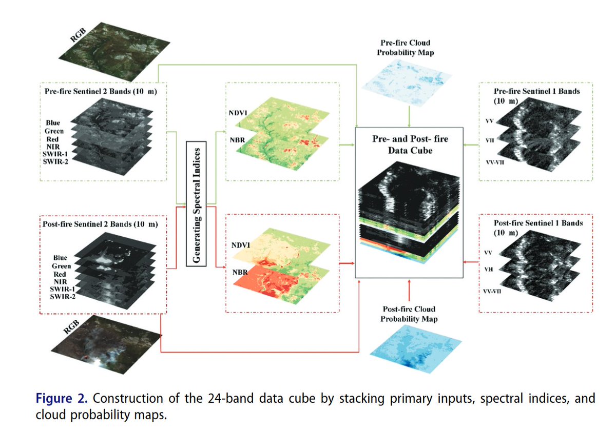
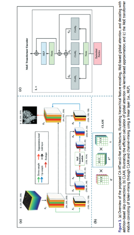
💌 This study addresses the limitations of existing #forest #burnedarea detection (#FBA) approaches, which are constrained by challenges in multimodal #dataintegration, the high computational complexity of attention mechanisms, and #cloudcontamination in optical satellite imagery. To overcome these issues, it proposes a Cloud-Aware Mixture-of-Experts Linear Transformer #UNet that integrates #Sentinel1 #SAR and #Sentinel2 #opticaldata through dynamic weighting and an efficient MoE-based linear attention framework. The model achieves superior segmentation accuracy and faster inference compared with several state-of-the-art architectures, while remaining subject to higher memory demand and occasional misclassification of water bodies, highlighting areas for further optimization in operational #wildfire monitoring.
#Deeplearning #remotesensing #GIS #dataanalysis #BigData #forestfire #machinelearning #changedetection #ecologicalmonitoring
📢 CA-MTransUNet: Cloud-Aware Mixture-of-Experts Linear Transformer U-Net for forest burned area (FBA) mapping using Sentinel-1 and Sentinel-2 images by Sahand Tahermanesh, Ali Jamali @ali_jamali86, Armin Moghimi @ArminMoghimi2, Amin Mohsenifar, Ehsan Khankeshizadeh & Ali Mohammadzadeh
👉 https://t.co/8VpgLJNGFU
💌 This study addresses the limitations of existing #forest #burnedarea detection (#FBA) approaches, which are constrained by challenges in multimodal #dataintegration, the high computational complexity of attention mechanisms, and #cloudcontamination in optical satellite imagery. To overcome these issues, it proposes a Cloud-Aware Mixture-of-Experts Linear Transformer #UNet that integrates #Sentinel1 #SAR and #Sentinel2 #opticaldata through dynamic weighting and an efficient MoE-based linear attention framework. The model achieves superior segmentation accuracy and faster inference compared with several state-of-the-art architectures, while remaining subject to higher memory demand and occasional misclassification of water bodies, highlighting areas for further optimization in operational #wildfire monitoring.
#Deeplearning #remotesensing #GIS #dataanalysis #BigData #forestfire #machinelearning #changedetection #ecologicalmonitoring
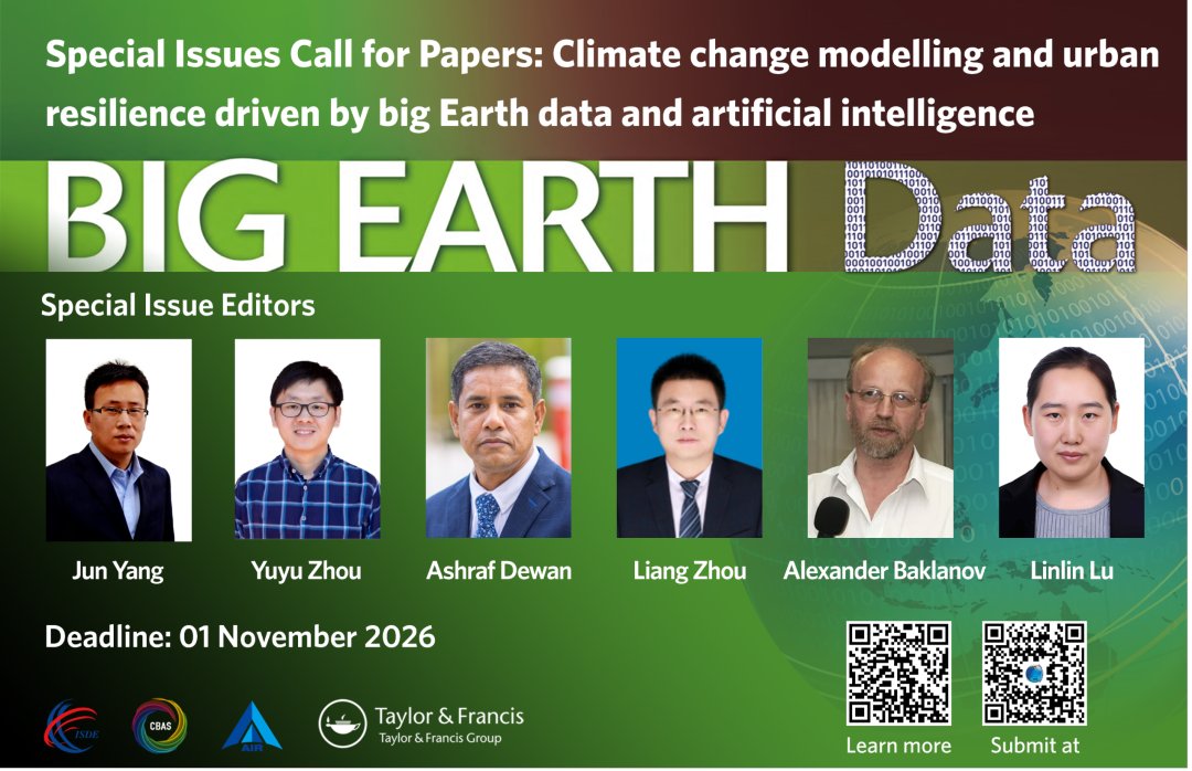
📢 Call for Papers | Climate change modelling and urban resilience driven by big Earth data and artificial intelligence
👉 https://t.co/vjEwOCshh5.
💞 Guest Editors: Jun Yang, Yuyu Zhou, Ashraf Dewan, Liang Zhou, Alexander Baklanov, Linlin Lu
🌍 Background & Aim
With the intensification of global #climatechange, its impacts on natural #ecosystems, socio-economic structures, and human #health are becoming increasingly pronounced. #Urban areas, home to over half of the world’s #population and engines of the global #economy, are both critical contributors to and frontline responders to this crisis. This Special Issue aims to showcase the latest global research findings and explore the application of big Earth data and #AI technologies in climate change modeling, promoting interdisciplinary integration and advancing the development of a more sustainable and resilient society.
🔍Potential Topics (Including but Not Limited To):
• Improvement of #climate models driven by big Earth data
• AI-Enhanced climate change prediction and extreme event #forecasting
• Integration of multi-source data and climate change modeling
• Application of AI in the calibration and validation of climate models
• Climate change simulation supported by #cloudcomputing and #highperformancecomputing (#HPC)
• Application of big Earth data and AI in urban climate #riskassessment
• Optimization of Nature-Based Solutions (#NBS) with AI and #bigdata analytics
• Quantifying climate impacts and adaptation progress using #SDG indicators
• Equity and justice in urban #resilience
• Adaptation to #extremeclimate in mountainous cities
#BigEarthData #AIinClimate #UrbanResilience #SpecialIssue #bigearthdata #digitalearth #earthobservation #remotesensing #GIS #geoscience #GeoAI #ArtificialIntelligence #sustainability #callforpapers