It’s pretty cool to see this massive Kelvin Wave move across the Pacific as our El Niño develops
Currently we have temperatures of +1.126°C in Niño 3.4, but as you can, the whole basin is quite warm right now
Just an impressive event unfolding here
@WxRiskGrains Thanks, my friend! I’m working on producing a lot of reanalysis maps to share some of the climate patterns across the Southern Hemisphere!
Provavelmente, estamos diante de um recorde de fase positiva da Oscilação Antártica (AAO). O contexto atmosférico inclui um fluxo altamente zonal do jato polar desde meados deste mês, com a principal rota de propagação da energia das ondas de Rossbyao longo do jato subtropical.
@CarlosA70456848@JMolinaPelayo Lluvias en Santiago, quizás hacia el final de la primera semana de julio, amigo. Pero todavía pueden cambiar muchas cosas. ¡Un abrazo!
O verão mal começou no Hemisfério Norte e uma forte onda de calor já atua sobre a Europa, com máximas acima dos 40 °C. Três óbitos foram reportados no fim de semana, e a França registrou 44,3 °C nesta terça-feira (23), em meio ao dia mais quente de sua série histórica.
O Niño 3.4 registra a maior temperatura para junho, sinalizando a força do El Niño dos próximos meses. Seguem os alísios fracos e o aquecimento contínuo. A atmosfera já responde gradualmente com OLR negativa e o par de anticiclones anômalos ladeando o equador: resposta de Gill.
@espana_76 Para tu región no se esperan anomalías meteorológicas relevantes en los próximos días. La semana estará marcada por dos vaguadas de onda corta, con aumento de nubosidad y riesgo de lluvia los días 24 y 26. ¡Saludos!
Primeira onda de frio do inverno a caminho: uma dispersão para leste das ondas de Rossby está varrendo o Pacífico em meio à corrente de jato em direção à América do Sul, resultando em um padrão de onda amplificado crista–cavado, cuja fase é favorável à incursão de ar frio na AS.
@AdenirQuirino Legal man! Vai ser uma semana fria e com geadas abrangentes no estado do Rio Grande do Sul! Se der geada ai na sua cidade, registre! Grande abraço. 😀
WMO works with partners to strengthen forecasts and warnings of sand and dust storms which have a major impact on health and air quality.
Find out more: https://t.co/QqF9BPmZsJ
See the latest forecasts from WMO's @Dust_Barcelona: https://t.co/k68I3MwGhc
ℹ According to current forecast scenarios, a significant disruption of the polar vortex is expected during the first half of February as a result of a sudden stratospheric warming event, with a possible split of the vortex into two distinct circulation centres.
ℹ This evolution would lead to a marked weakening of the stratospheric zonal flow and may, with a certain time lag, propagate downward into the troposphere. If effective stratosphere–troposphere coupling develops, the second half of February and early March could be characterised by enhanced meridional flow and an increased likelihood of cold Arctic air intrusions into the mid-latitudes. The magnitude and surface impact of this response remain uncertain and will depend on the subsequent dynamical evolution of the circulation.
➡ The video shows the projected evolution of stratospheric winds at an altitude of around 30 km over the coming days (https://t.co/hOUtweyZcF).
The severe winter storm ripping across the south and east of the US and parts of Canada has caused mass power outages and the cancellation of thousands of flights. https://t.co/N9B1w1xC8X
With inland temperatures from just below 0 to the single digits F, 1-minute @NOAASatellites#GOESEast / #GOES19 True Color RGB images showed nearshore ice in southern Lake Michigan (along and just off the coasts of WI, IL, and IN). https://t.co/EO2HcRc8Qr;
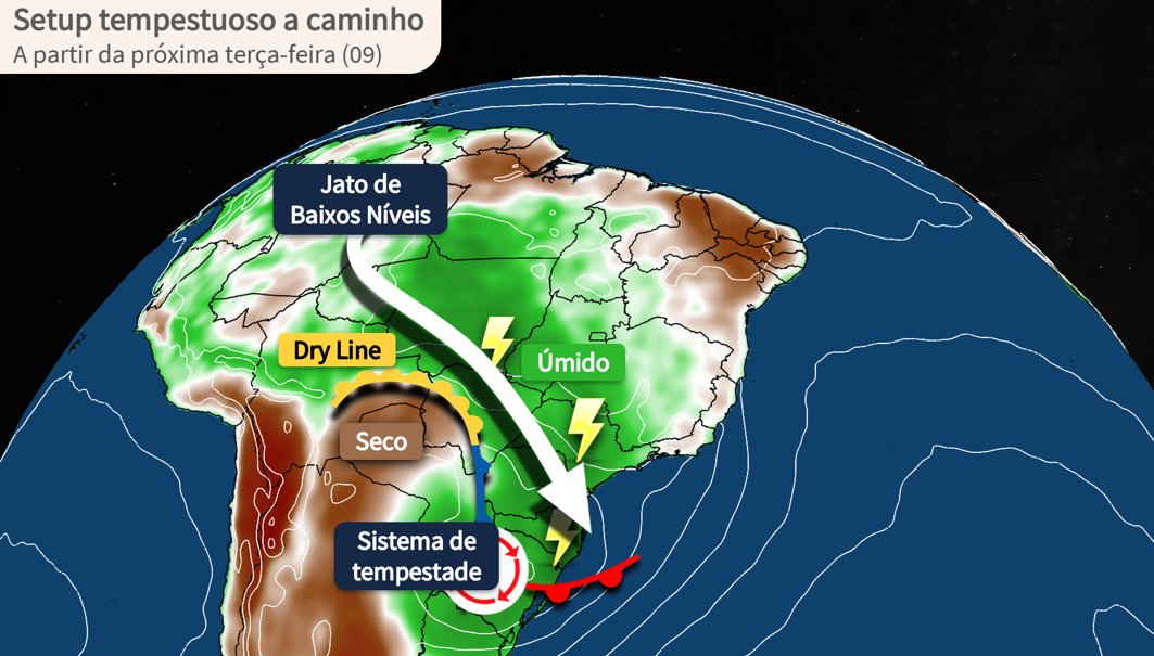
SETUP CLÁSSICO DE TEMPO SEVERO NA PRIMAVERA 🌩️
A partir da próxima madrugada, as condições meteorológicas se agravam entre o Rio Grande do Sul e o norte da Argentina. Durante a sexta-feira (07), microexplosões e tornados não estão descartados em partes da região Sul do Brasil.
Furacão Melissa devastando a Jamaica! 😞
Já se fala no sexto furacão mais forte da história no Atlântico, desde que começaram as medições mais consistentes em 1979. Outro recorde também é provável, o de furacão com menor pressão atmosférica no momento do landfall.
Melissa's eye in Jamaica:
Once the eyewall rages through, an eerie silence will abruptly fill the air as the calm, 10-mile-wide eye arrives. Skies will briefly clear. But that tranquility doesn’t signal the end of the storm — it will be fleeting and only marks the halfway point.