Bringing you 24 hour up to date information on Emergency Services, Traffic, & other large events nearby! Info from multiple SCANNERS. All tweets are unconfirmed
“Just Remember, in a city where our officers are not safe, it’s going to be hard for everyone else to be safe”
God bless our CPD, and god bless Officer Enrique Martinez. You are a hero sir. 💙
Officer Enrique Martinez embodied courage and honor when he was fatally shot while conducting a traffic stop.
On Monday night, we honored his bravery as we escorted him to the Cook County Medical Examiner's Office.
End of Watch: November 4, 2024.
After the morning round of showers and t-storms clears out this afternoon. Some destabilization will occur across northern and central Illinois. New development could pose a brief tornado and hail risk from 3pm-7pm this evening. The most significant tornado threat this afternoon and evening will continue to be across southern Illinois with a very volatile environment in place for strong tornadoes 2pm-11pm. I don't have a lot of expectations for new storms across northern Illinois today but we'll see. #ilwx
**Update for northeast, north-central Illinois, and northwest Indiana for Monday**
- A high end severe weather event is possible across northeast Illinois and northwest Indiana with all hazards possible including tornadoes, damaging wind gusts, and large hail. One variable that could limit the severe weather risks will be any lingering showers and t-storms late morning and afternoon. This could hold back overall instability as new storms develop late afternoon and evening. A shorter window between rain/storms, lower the severe risks could be. If we clear out the convection by late morning, then there should be plenty of destabilization before the new round moves in.
- Timing for severe weather, 3pm through midnight across northeast Illinois. 5pm through 2am across northwest Indiana. It may start as early as 1-2pm across Iowa and Missouri on Monday and this activity will quickly grow into supercells as they move into western Illinois Monday afternoon/early evening.
- This is a dynamic system with nearly perfect ingredients for significant severe weather. As it looks this afternoon, the highest risk for all hazards will be from southeast Iowa, eastern Missouri into central and southern Illinois 3pm through midnight on Monday. Less confidence in the strongest tornadoes across northern Illinois especially with the variable of lingering clouds and rain. #ilwx
**A Severe Weather and Tornado Outbreak is possible Monday afternoon into Monday night across Illinois**
- This has the highest ceiling of the season so far for significant hazards across Illinois including northern Illinois with damaging wind gusts, very large hail, and long tracked intense tornadoes (EF-3+).
- The highest confidence in these intense storms will be in the pink outlined area across Illinois. We are less confident across far northern Illinois and Chicagoland as morning/afternoon convection may hold back the overall moisture and instability. Further south and west across northwest Illinois down into southern Illinois, an environment extremely favorable for strong, long tracked tornadoes will be possible to likely from Monday afternoon into Monday night. These storms will transition into a qlcs tornado threat after dark Monday night as it moves east across Illinois into Indiana.
- Upgrades in this outlook are expected. Could we see some shifts, absolutely given we are over 48 hours out but at this time, the highest tornado risk is in the pink outlined area.
- We will update this forecast numerous times over the weekend and into Monday, any plans Monday afternoon into Monday night need to keep the weather in mind and make sure you have a place to go if warnings are issued. #ilwx
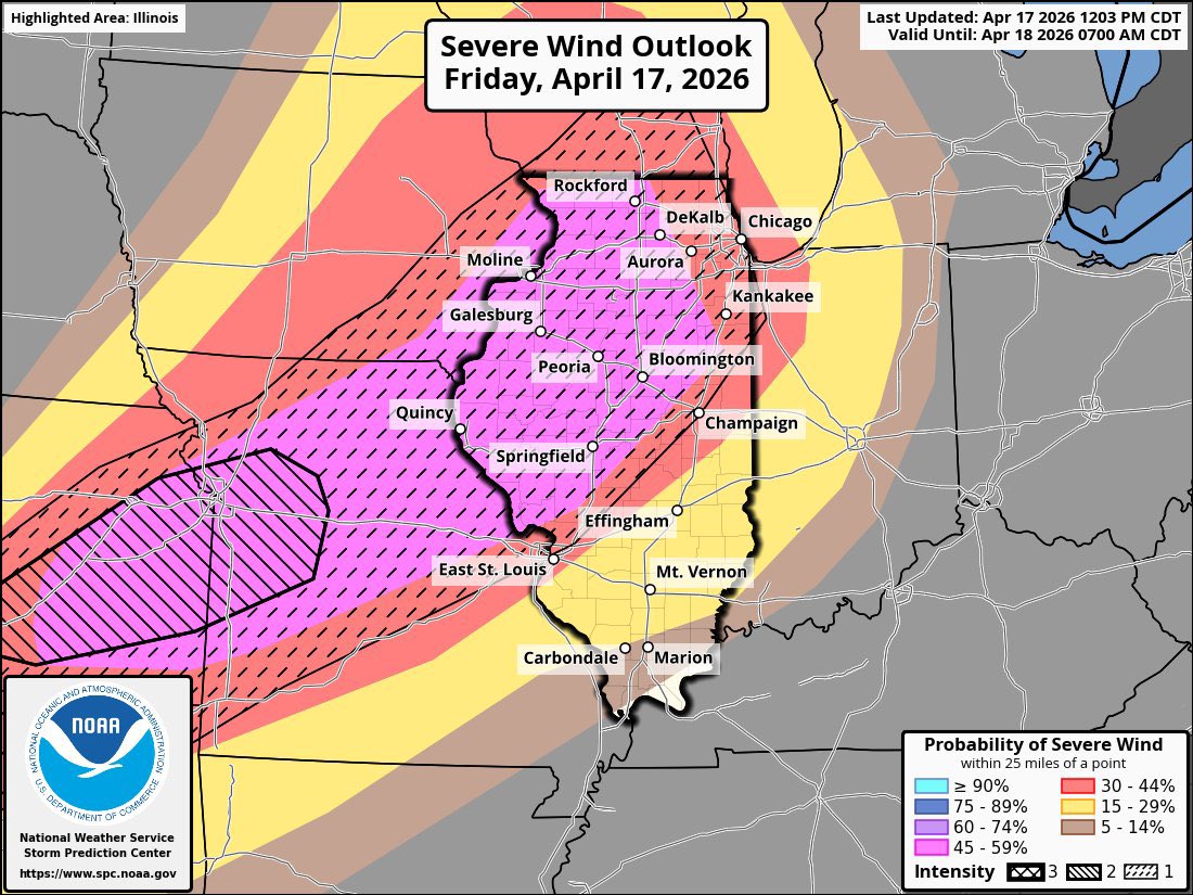
1230pm Update: Everything is on the table today across northern Illinois including tornadoes and significant damaging wind gusts.
- Strong T-Storms are developing across Iowa this afternoon and these will move into an environment favorable for all hazards including very large hail, significant wind gusts, and strong tornadoes. That threat will continue through 7pm before these storms begin to transition to significant damaging wind producers with embedded tornadoes. That threat will move across northern Illinois this evening into tonight including into Chicagoland.
- Timing, storms will continue to develop across Iowa this afternoon and early evening (now through 6pm). Storms will move east into northwest Illinois late this afternoon and into this evening across northern Illinois. 4pm through midnight.
- Be prepared and have shelter when these storms arrive, they will certainly pack a punch in most locations but they should start to weaken as they approach Chicago and northwest Indiana tonight around 8-10pm. #ilwx
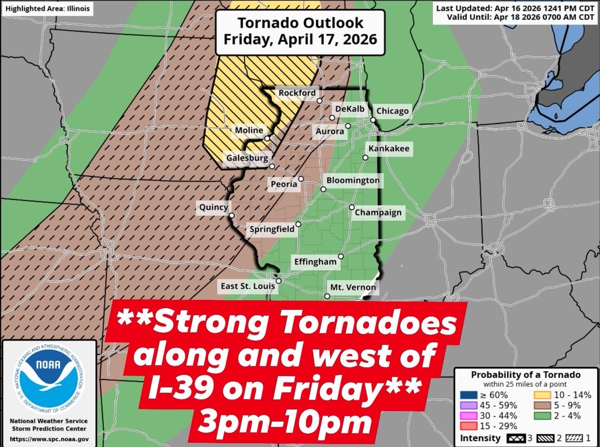
**Strong tornadoes are possible on Friday**
- The NWS has upgraded portions of northwest Illinois, Wisconsin, and Iowa to a 10% hatched level 2, meaning EF-3+ tornadoes are possible. Elsewhere, a strong tornado can also be found along and west of I-39. Both supercellular and QLCS-type tornadoes are possible from 3-10pm. #ilwx
Tomorrow looks like a classic tornado day for Illinois, southern Wisconsin and eastern Iowa. The yellow outlined area on the graphic below has tornado potential tomorrow no questions about it given strong shear in place and plenty of low level cape. The … https://t.co/0aSDlzVEA9
Confidence is growing on the probability of at least a few tornadoes Thursday afternoon and evening from eastern Iowa into northern Illinois. This computer does not predict overall tornado strength, just the odds of one occuring. It's hard to say at this… https://t.co/5zi11NJM8W
#Cubs home opener is looking a bit rough around the edges if I say so myself.
Check out the temps! 40’s at the game but if you go 10-20 miles west we are mid 70’s!! Bring a jacket if you’re heading out! #ilwx
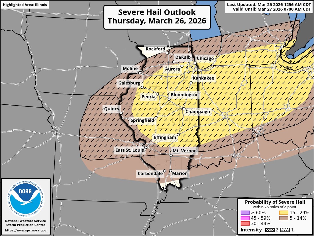
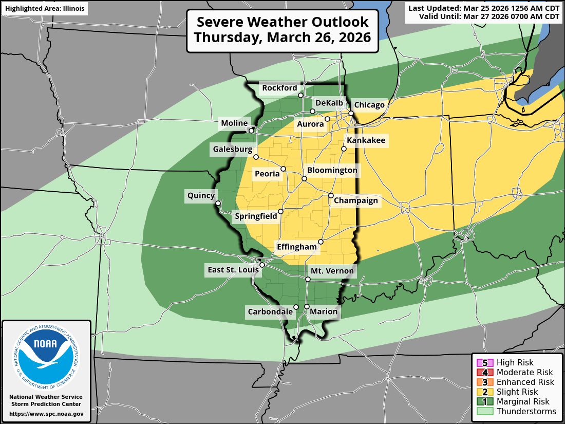
1245pm Update: Portions of northern Illinois into Indiana have been upgraded to an ENHANCED risk for severe t-storms Thursday late afternoon and evening (3pm-8pm). Very large hail (tennis to baseball size hail) and damaging wind gusts are the main risks,… https://t.co/ZfQscm9Xi1
⚡️0830am Update: Severe Weather expected Thursday across the area! All Hazards possible!
A cold front will push through the area Thursday bringing cold air in along the backside. Along, and ahead of this front will be warm, unstable air which leads us to a very favorable environment for severe weather.
Storms will fire around 1-2 pm and begin treading E. Timings are 3-7pm north of I-80 and 4-9pm S of I-80.
*If* models stay consistent right now, I’d say this could be a rather large hail producer more so than tornadoes.
**All Hazards are Possible across Northern Illinois on Thursday**
- A strong cold front will be moving through northern Illinois Thursday afternoon and evening bringing much colder air on the backside. Along and ahead of this front, very warm and unstab… https://t.co/tkt1ytjt7i
BREAKING: CPD formally charges Jose Medina - of the 6800 block of Sheridan Rd. - with five felony counts including Murder in the shooting of Loyola U Student Sheridan Gorman. DHS has claimed Medina is undocumented and has put out a detainer to the jail to hold him in custody.
This is Sheridan Gorman (18)
She went for a walk by a lake in Chicago on Thursday and was kiIIed by an illegal from Venezuela who came under Biden
Zero protests
Chicago police have arrested a 25-year-old Rogers Park man in connection with Thursday’s fatal shooting of Loyola University freshman Sheridan Gorman, according to records obtained by the Tribune.
https://t.co/64tx41xAvf
5am: Snow is falling across northern Illinois this morning but should wrap up over the next couple of hours. Slick and icy roads are being reported. #ilwx https://t.co/PhySNCQ8aq
Darren Bailey is projected to win the Republican Illinois Governor nomination, setting up a rematch with Governor JB Pritzker in November.
https://t.co/JEKm7Cm7Cw
A clipper system will bring light snow to northern Illinois tonight into tomorrow morning.
Timing:
9pm Tuesday through 6am on Wednesday
Amounts:
A coating to 2 inches for most locations
Hazards:
Icy roads tonight into tomorrow morning
#ilwx https://t.co/ZMqqx6kYXp