We share our social media terms of use agreement every year as a reminder of what's needed to keep this method of communication beneficial for everyone. Thank you.
SOCIAL MEDIA TERMS OF USE AGREEMENT:
https://t.co/MckV7UEHMR
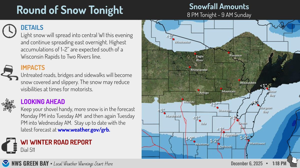
Light snow will spread into central WI this evening and continue spreading east overnight. Highest accumulations of 1-2” are expected south of a Wisconsin Rapids to Two Rivers line. Untreated roads, bridges and sidewalks will become snow covered and slippery. #wiwx
Texans Helping Texans:
Matt and Kelly Mattingly, owners of Signarama in Boerne, are producing hundreds of thousands of signs reading “Hill Country Strong” in an effort to rally support and raise funds for communities impacted by the floods #HillCountryStrong
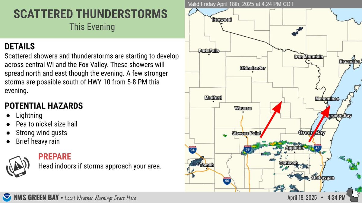
Scattered showers and thunderstorms are starting to develop across central WI and the Fox Valley. These showers will spread north and east though the evening. A few stronger storms are possible south of HWY 10 from 5-8 PM this evening. #wiwx
Scattered showers and thunderstorms are starting to develop across central WI and the Fox Valley. These showers will spread north and east though the evening. A few stronger storms are possible south of HWY 10 from 5-8 PM this evening. #wiwx
It's an odd time we live in. Severe weather outbreak was talked about 8 days out, lead times for outlooks and watches were incredible. Still, 40 people so far have died. Then, to cap it all off, online commentary is focused on this odd notion that nothing happened and it was all hype and a bust?? I'm not even sure where we start with the odd social science of this, which seems to be branching off from the actual incredible advancements in meteorology and forecasting.
Temperatures will trend warmer through the end of the week. By Friday areas in central WI may reach the 70s for the first time this year. A strong low pressure system is forecast to impact the upper Midwest late Friday through Saturday. #wiwx
We are aware of the NHU power outage in the rural area north of the City. Please do not contact 9-1-1 unless you have an emergency. Updates will follow.
We are aware of the NHU power outage. Affecting the East side of our territory, Steinthal, County Road T, Danes Rd, Honeymoon Hill etc.. Please do not contact 9-1-1 unless you have an emergency. Updates will follow.
If you have outdoor or travel plans this Friday or Saturday you'll want to keep an eye on the forecast. Multiple rounds of thunderstorms and heavy are forecast to move across the region. There is an increasing risk for stronger to severe storms, particularly on Saturday. #wiwx
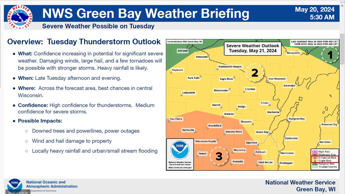
On the left side of the graphic is the Storm Prediction Center Day 2 severe weather outlook across the upper Midwest. On the right side of the graphic gives details about the upcoming scenario, timing and confidence levels. #wiwx
[6/3/24] 4:20pm
⚠️ The threat for severe weather is expected to continue through this evening, with the best potential for strong to severe storms south of Hwy 10. Small hail, damaging wind, & isolated flash flooding with heavier rainfall will be the main threats.
#wiwx
A storm line is entering our county from the west. The storms aren't showing as severe, but there will be some heavy rainfall and very gusty winds associated with them. Be sure to secure your loose objects. #wiwx
There is a good chance for thunderstorms Fri afternoon and evening. A marginal risk of severe storms exists for our area with hail and gusty winds appearing to be the main threats. #wiwx
Confidence is increasing in strong to severe storms Saturday afternoon with large hail and damaging winds being the primary threats. Stay informed. #wiwx











![NWSGreenBay's tweet photo. [6/3/24] 4:20pm
⚠️ The threat for severe weather is expected to continue through this evening, with the best potential for strong to severe storms south of Hwy 10. Small hail, damaging wind, & isolated flash flooding with heavier rainfall will be the main threats.
#wiwx https://t.co/hSqfkGdwDV](https://pbs.twimg.com/media/GPLayDhakAAbqoc.jpg)