Long post alert::
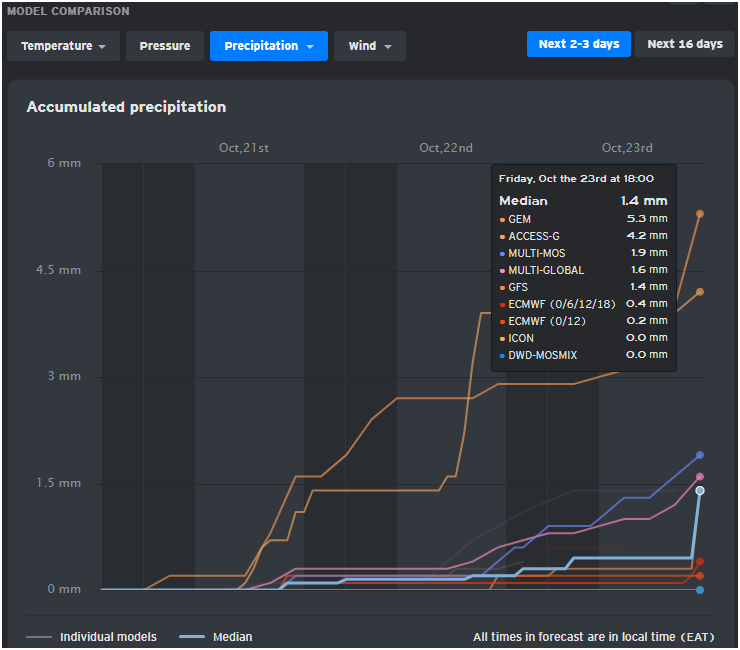
Due to overwhelming DMs & mentions especially from #Nairobians regarding the current ongoings as the Oct-Nov-Dec rainy season begins, I will resume regular weather model output updates for the #Nairobi Metro area.
Please note:
1. These are not the ordinary model prediction times. Erratic data assimilation, model biases, jumpiness and limitations in downscaling have become more amplified due to the fast-evolving forecasting conditions in the strong El Nino background in the Pacific. This ocean is the largest in the world, covering over 160Million sq Kms and whatever happens there has immense potential to influence global weather & climate by altering trade winds, atmospheric pressure, global wind/moisture circulation and storm tracks.
2. El Nino is typically associated with wetter-than normal conditions over Eastern Africa including Kenya. But there are intra-seasonal and inter-annular climatic factors that influence/modulate the extent to which El Nino enhances precipitation especially over the OND season. These include the Madden-Julian Oscillation (MJO), Kelvin waves, Southern Annular Mode (SAM), The Indian Ocean Dipole (IOD) and tropical storms/depressions in the Western & Central Indian Ocean.
3. I'll be posting a mix of deterministic & ensemble forecast for short & medium range predictions only.
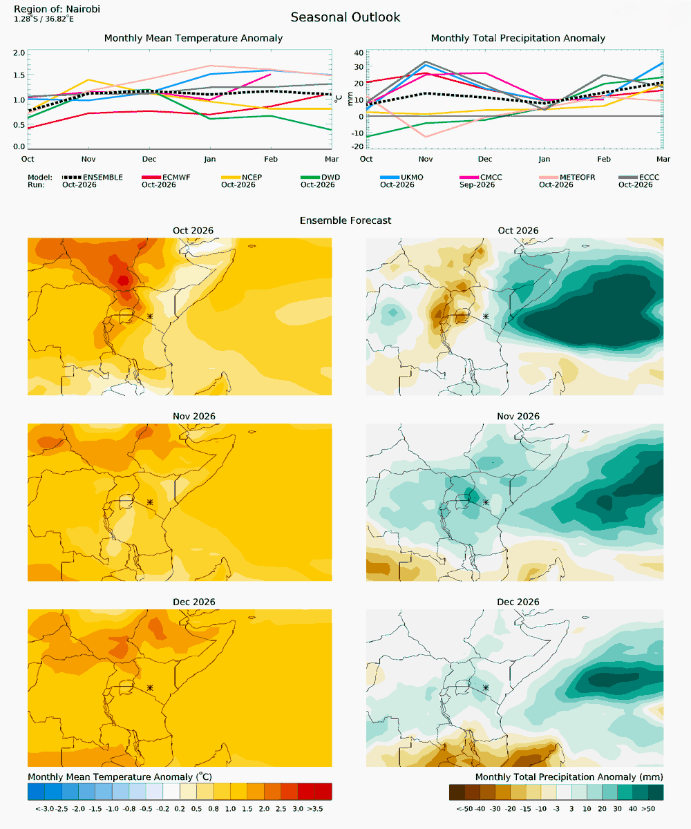
Now, what does the latest long range seasonal data for Nairobi say?
1.On the temperature side, models indicate that it will be warmer than usual throughout quarter 4 2026 into early 2027. Some individual models show up to +ve 1.5C anomalies, while the lowest indicates +ve 0.5C anomaly. The median is about +ve 1.1C anomaly which is quite feelable for a concrete jungle like Nairobi.
2. The precipitation side has just gotten more complex, with short range & medium range predictions not aligning with the sub-seasonal/long range forecasts shared earlier. Why? There is a serious tag-of-war between the strong El Nino and intra-seasonal inter-annular factors mentioned above.
The most recent precipitation anomaly data still indicates a possibility of above-normal precipitation in Nairobi this season. Even through-out Jan, Feb & March next year.
But if you are keen enough, you see 3 out of the 7 models assessed indicate normal-to-below normal precipitation at least in Oct & Nov. These outlier predictions actually do stand a chance of coming true, depending on how the modulating factors play along. There is notable model agreement on enhanced precipitation from Jan 2027 onwards, while the model curve spread is much larger this season, indicating greater uncertainty in the prediction.
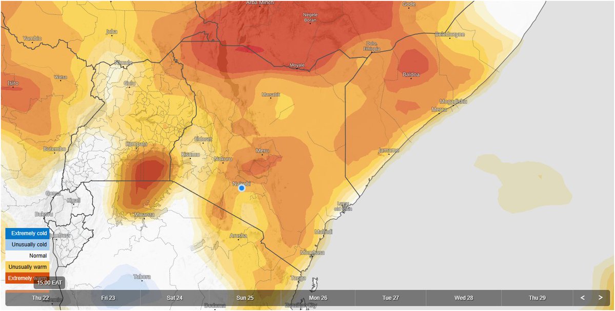
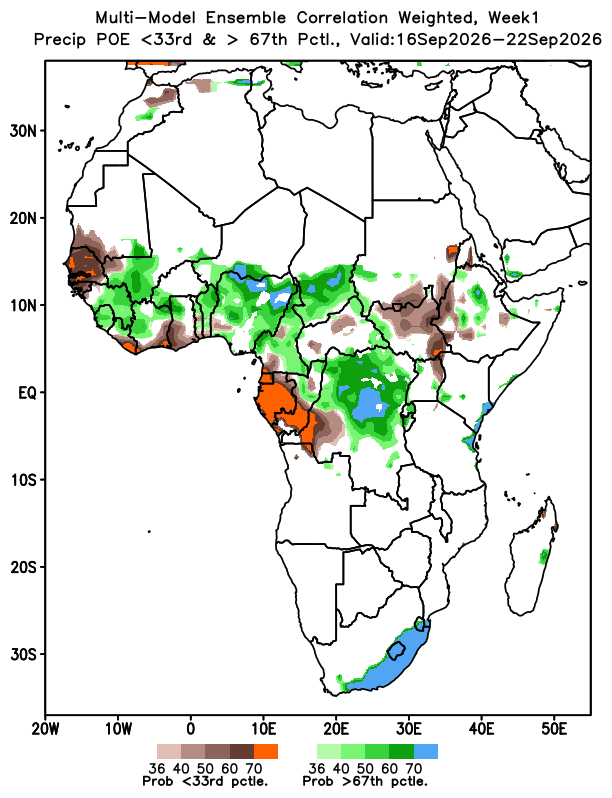
Tropical Storm #Agueda continues to reinforce a large area of lower level wind curls & divergence over the Horn of Africa, including much of North Eastern, Eastern, the Coast, Central & #Nairobi regions of #Kenya. These wind patterns are adverse to deep convection & rain cloud formation, leaving the mentioned regions unusually sunny, hot & dry (see extreme forecast chart). Any attempt of rain cloud formation is getting thwarted on real-time basis.
There's some notable moisture transport from Lake Victoria by the westerlies into parts of the Rift, Western & Nyanza where atmospheric convergence will lead to precipitation tis afternoon.
Multi-model ensemble temperature outlook for #Nairobi for the next 7 days.
Max daytime temps at 3PM remain high for the next 4 days in a row, with possible highs of 28C to 30C. Tomorrow Thursday and Friday will be particularly hot with max daytime temps breaching 30C in some places like Eastlands.
Cooler temps expected from 26/10
Watch:
The tropical activity in the Indian Ocean has triggered high tides in the open sea that can easily topple fishing boats. Preliminary model forecasts do not show any big impact on precipitation from the storm.
The cyclone heading northward would have been a big blessing in disguise for Kenya if it made a landfall somewhere in Somalia.
The infusion of its moisture would have brought lots of seasonal rain to North Eastern & Eastern Counties.
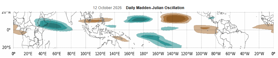
Interesting developments in the Western indian Ocean as the MJO trpical atmospheric wave enters phases 2 & 3.
Massive twin cyclones develop in the Indian ocean, off the East African coastline, causing severe disruption of easterly winds, cutting-off moisture transport into Ethiopia, Somalia & much of coastal, Eastern & NE #Kenya for about one week from tomorrow. This will significantly suppress rainfall in these parts of Kenya, as well as Southern/Eastern Ethiopia & Somalia where relentless El Nino powered wet spells have led to very heavy rainfall and flooding in recent weeks.
The cyclone in the north will drift towards Southern Yemen and probably make a landfall there on or around 24th October while the other one wil drift southwards and dissipate in the South Western Indian Ocean, North-East of Madagascar. Its outer bands may cause intense rain and storm surges in the Seychelles.
As far as weather/climate prediction are concerned, there are many factors/parameters you need to put into consideration before you make a conclusion. Some parameters are linear others are non-linear. The former is the obvious things you see in the forecasts, while the latter (the geophysics) is not obvious and that's what many people miss.
It is still very early to say that we've escaped the wrath of the El Nino at this point in time because of one single factor- the IOD.
Although still relatively in a weak +ve phase at 0.88 degrees, the IOD mode index is on it's way to the expected seasonal peak of +ve1.1 to +ve 1.2 degrees later this month or early Nov. That index, coulped with the El Nino could still do the unthinkable before the season ends.
As we speak, the Madden Julian Oscillation (MJO) tropical atmospheric wave convective core, which is the KING of wet spells in the region is entering the Equatorial East Africa & the Indian Ocean any time from now. We will see significant tropical activity in the Indian Ocean from this weekend and highly enhanced rainfall in most Counties in the Western half of Kenya (Nairobi included) in the second half of October.
Some models show that the MJO signal could stay for weeks in the Indian Ocean while others show it might go a full 360 degrees and re-enter our region again in early Nov, bringing another round of probably very heavy rains & prolonged wet spells this time at a very high amplitude, which is typical of the MJO in the OND season under El Nino influence.
The risk of heavy rains and prolonged wet spells remains a reality untill at least June 2027.
🚨Heavy to very heavy rainfall alert this afternoon into the evening in the following regions of #Kenya :
1. Pokot Central
2. Pokot South
3. Uasin Gishu- Moiben Sub-County
Watch:
"Hii jua imewaka sana. Hakuna El Nino" 😃😃
If you jump into a TV series at Season 10 Episode 10, you will lose the plot and you'll never understand the storyline.
Even with all the technology at our disposal, accurate & reliable weather/climate forecasting is still a complex and daunting task. It requires patience and a follow-through of all updates for one to understand what is going on weather-wise. It also takes time for the forecasts to verify.
The earliest time we can say we've successfully survived the drought/floods induced by strongest El Nino on record is at the end of May 2027. Between now and then, the weather can change by a big magnitude in very short order and catch you by a big surprise.
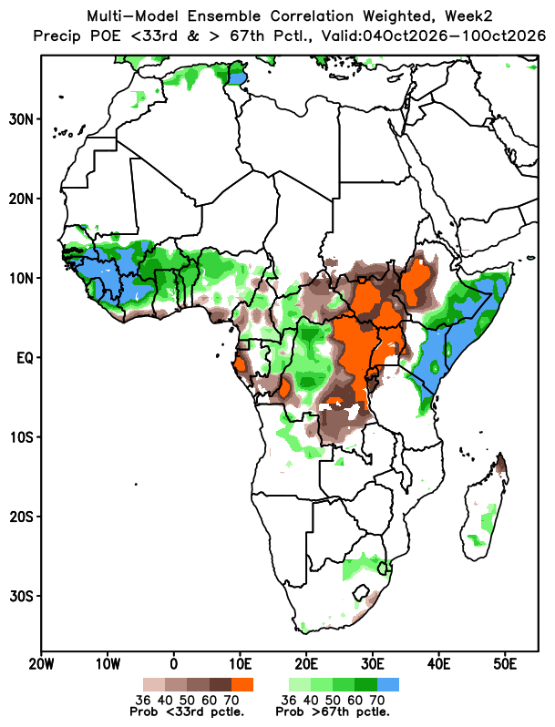
In other news, the OND rainy season kicks off in North Eastern, the Coast, Eastern, parts of Mt #Kenya/Central & Kajiado any time from next weekend (4th of October onwards).
The most recent skill-weighted consolidated multi-model probability of exceedence charts depict over 70% chance of precipitation exceeding the LTM at this time of the year. All the mentioned regions' precipitation scenario simulations lie above the 67th tercile, pointing to a very high chance of heavy-to-very heavy rains.
This prediction is in line with the quoted post in which I rolled out the chronology of heavy seasonal rains and the order in which the Counties will be impacted.
Key Update: OND Rainy Season
The September 2026 equinox will occur next week as stated in the quoted tweet.
On 29th/30th September , exactly 7 days after the equinox, a high pressure zone develops in the Arabian Sea somewhere between the Somali Coastline & the Indian Sub-Continent, effectively terminating the South West Indian Monsoon winds.
As we enter October, North Easterly trade winds start flowing towards Eastern Africa, joining the already established South Easterlies indicating a southward shift of the ITCZ into Eastern Ethiopia, Somalia & Northern #Kenya .
These events mark the change of seasons, with heavy, flooding rains powered by El Nino & the evolving +ve IOD expected to hammer Somalia, Eastern Ethiopia & NE Kenyan Counties of Mandera, Marsabit & Wajir from the beginning of Oct.
By mid-Oct Eastern Kenya, the Coast & probably Nairobi & parts of Central are expected to have received substantial rains.
Short-range forecasting models make a last-minute move to align with the medium-range forecasts regarding the unsettled weather in #Kenya, especially the coastal strip, tomorrow & Monday.
Geo-statonary satellite imagery shows a narrow band of tightly knit storm clouds that looks like an atmospheric river approaching the East African Coast.
This atmospheric river lands with huge volumes of precipitable water at the #Kenyan coast tonight, bringing very rainy weather conditions there tomorrow & Monday. There's a chance of flash flooding in some areas at the coast.
Further inland in #Nairobi, Central, Mt. Kenya East (leo nimegawanya Mrima 😃), Ukambani & parts of North Eastern, cool-to-chilly, cloudy and showery weather will dominate the weather tomorrow and Monday. Strong south easterlies in the Indian Ocean will do the good job of pushing moisture into Kenya's interior.
Model Output Update: Unsettled/Volatile Weather conditions Along the Kenyan Coastal Strip as we Head into the Weekend
The predicted wet spell along the #Kenyan Coast is set to reach its peak this weekend on Sunday.
Both numerical & machine learning models are well aligned and the actual outcome could easily exceed forecast expectations & the long term mean precipitation for this time of the year.
All Kenyan Counties bordering the coastline will receive moderate-to-heavy rains as strong Easterlies/South Easterlies push copius amounts of precipitable water in the region, including the Northern Coast of TZ.
Some of this moisture will be pushed by the strong trade winds deep into the Kenyan interior regions of North Eastern, Lower Eastern, Central (including Nairobi) & Mt Kenya East, bringing substantial pre-seasonal showers on Sunday/Monday.
Let me appreciate what you do here man. I read your posts like the weather bible, not just to know what the weather will be like but because I can see the lengths you’ve gone to be professional, in depth yet understood by the masses. I’m one of them and you’re doing. A great job man. Keep on keeping on.