☀️ GOOD FRIDAY MORNING, CENTRAL ARKANSAS!
We’re starting the day on the mild side, with most temperatures sitting in the upper 50s to lower 60s. Little Rock is around 61°, while several spots north and west are in the low 60s and a few southern locations are hanging in the upper 50s.
🔥 And yes… the heat is back again. Mostly sunny skies will send temperatures climbing quickly this afternoon, with highs generally in the upper 80s to lower 90s. Conway, Little Rock, Lonoke, Searcy and Pine Bluff are all around 92°, with Benton and Morrilton near 91°.
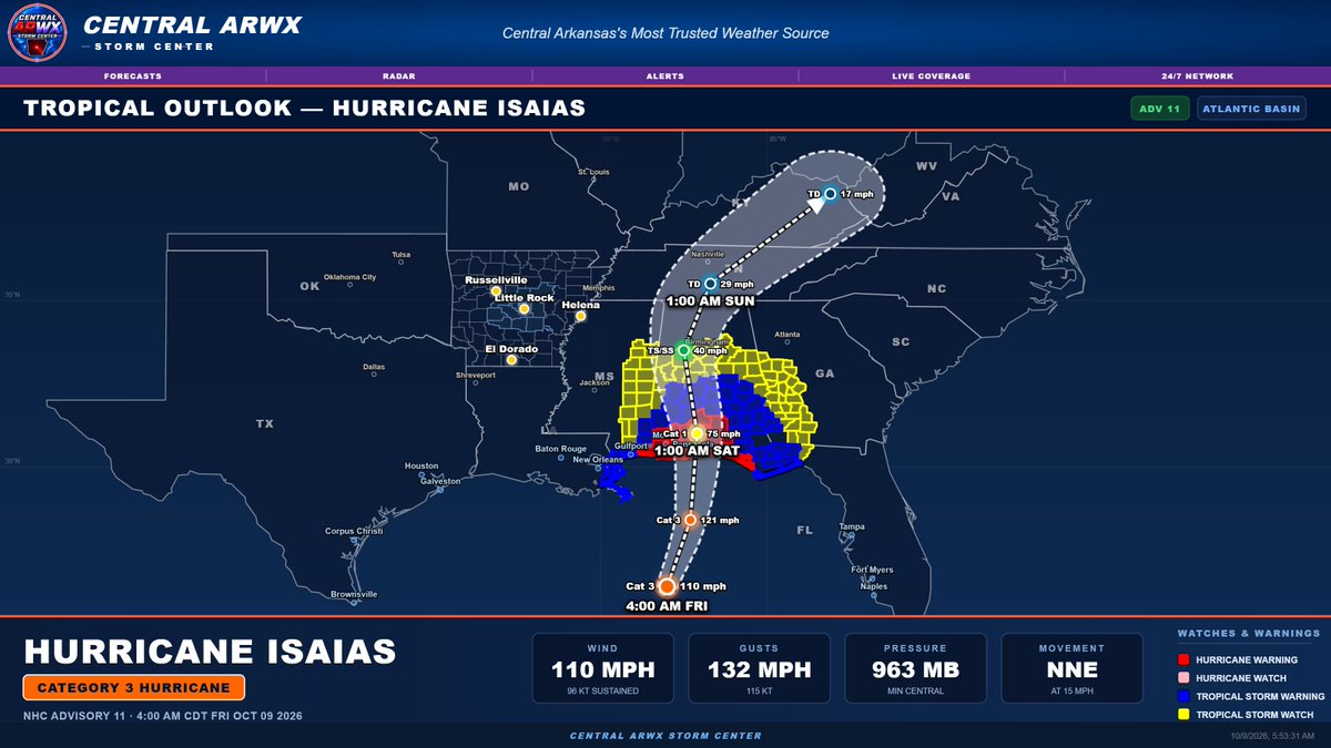
🌴 Hurricane Isaias is also strengthening this morning. The latest advisory has Isaias as a Category 3 hurricane with 110 mph winds and gusts to 132 mph. The system continues north-northeast toward the central Gulf Coast.
One thing I want to continue stressing: do not focus only on the center line. Impacts extend well away from the exact track, and the warning area remains quite broad. Even though the center is still expected to remain east of Central Arkansas, some influence on our weather Saturday is still possible, especially with increased wind and at least some shower potential.
💨 Right now, Saturday still looks breezy to windy, with the greatest tropical influence more likely across eastern portions of the area. The exact amount of rain will continue to depend heavily on the final track and structure of Isaias as it moves inland.
I’ll have another full tropical and weekend forecast update this evening as we continue narrowing down what Central Arkansas can expect.
📺 The Central ARWX Weather Network remains live 24/7 with forecasts, radar, alerts and tropical updates on Roku, YouTube, the website, and the PWA App.
#CentralARWX #ArkansasWeather #CentralArkansas #HurricaneIsaias #TropicalWeather #FridayForecast
~Lead Forecaster Derek
🌙 TONIGHT’S FORECAST + BIG WEATHER CHANGES AHEAD
A quiet night is ahead across Central Arkansas with mostly clear skies and temperatures settling into the upper 50s to lower 60s. Little Rock falls to around 62°, with most surrounding communities ending up between about 59° and 62° by morning.
🌴 Hurricane Isaias remains the big weekend story. The latest advisory has Isaias as a Category 2 hurricane with 105 mph winds and gusts to 127 mph. The exact center track remains east of Central Arkansas, but impacts can extend well away from the center, so the cone alone does not tell the whole story.
For us, Saturday remains the day to watch. The current forecast brings scattered showers along with gusty winds, especially across eastern and southeastern portions of the area. Rainfall coverage will still depend heavily on the final track, but even areas that see little rain could still experience a breezy to windy day.
🔥 After Isaias moves away, the heat comes right back. Highs rebound into the upper 80s and lower 90s early to midweek, with Tuesday around 92° and Wednesday near 90°.
⚡ Then our attention quickly shifts to the next major system late next week. Guidance continues to show the potential for strong thunderstorms, heavier rainfall, and a powerful cold front toward Thursday and Friday. Behind that front, a much colder air mass could arrive next weekend, with highs potentially dropping into the 60s and lows into the 40s.
So yes… we go from hurricane remnants, back to 90-degree heat, then potentially strong storms and a major fall cooldown. Because apparently October has decided to use the entire weather menu 😂
📺 The Central ARWX Weather Network remains live 24/7 with forecasts, radar, alerts, tropical updates and severe weather coverage on Roku, YouTube, the website, and the PWA App.
#CentralARWX #ArkansasWeather #CentralArkansas #HurricaneIsaias #WeatherForecast #TropicalWeather
~Lead Forecaster Derek
👀 A LITTLE TEASE AHEAD OF TONIGHT’S FORECAST…
We’ve been talking about a pattern change for a while, but the signal for late next week is starting to get a LOT more interesting.
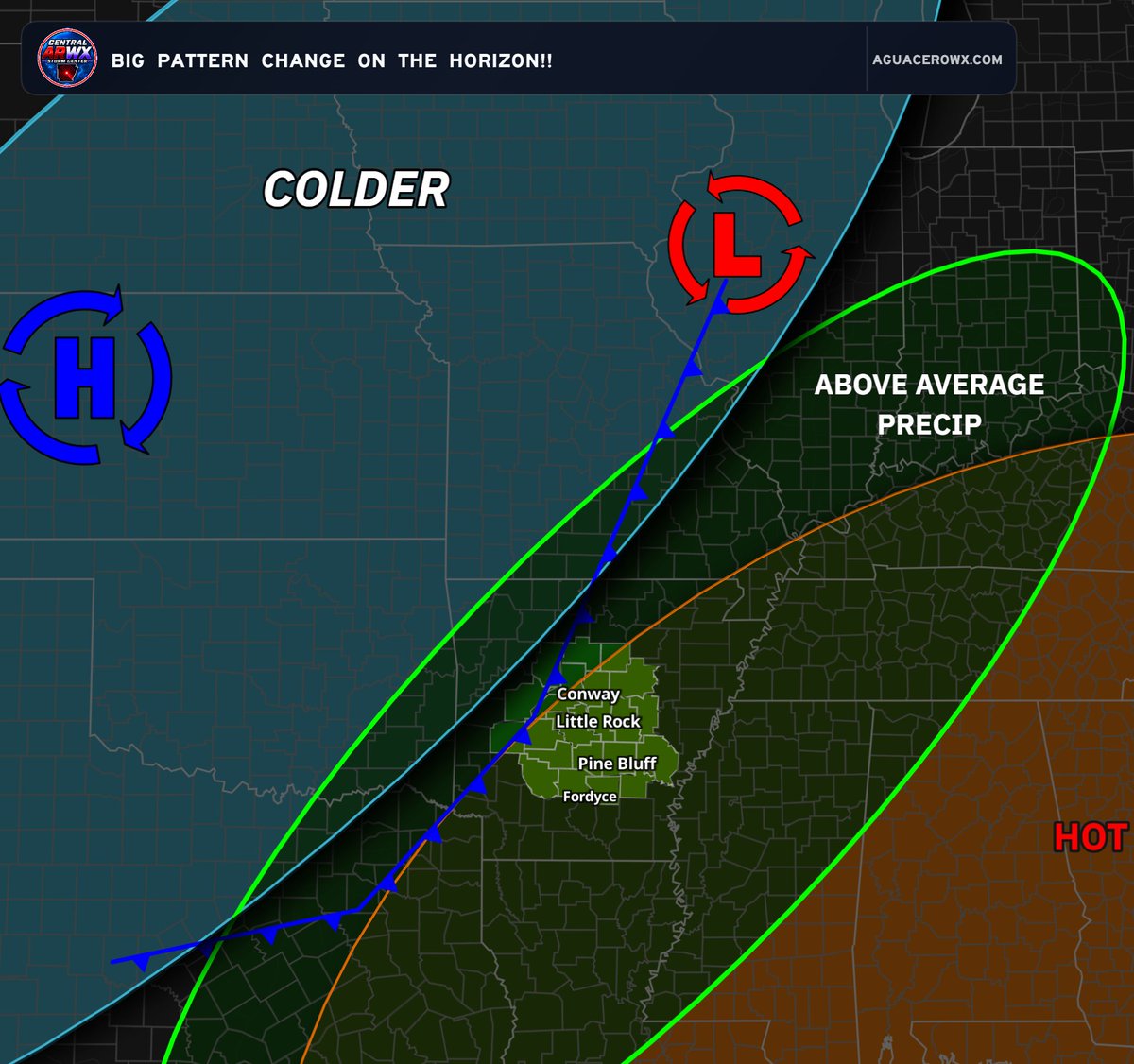
Right now, guidance is pointing toward a much stronger front eventually sweeping through the region, with a sharp contrast setting up between hot, humid air ahead of it and a much colder air mass building in behind it.
🌡️ Ahead of the front, parts of the region could still be dealing with highs near 90° and muggy conditions.
🥶 Behind it? Guidance is showing a much more fall-like — and potentially downright chilly — air mass with highs in the 60s, lows in the 40s, and even colder air farther northwest where 40s/50s for highs and 20s/30s for lows are showing up.
And of course… when you put that kind of temperature contrast together with a strong system, you know what we have to watch:
⛈️ Strong storms could become a concern along the front.
🌧️ A corridor of heavier rainfall may also develop.
❄️ And yes… some of the coldest air of the season so far may be lurking behind it.
There are still plenty of details to work out, especially exact timing and how strong the system becomes, but this is absolutely something worth watching.
I’ll break it all down in tonight’s full forecast, including the latest tropical update, the weekend impacts, and what this late-week system could mean for Central Arkansas.
Because apparently Arkansas is trying to cram summer, tropical weather, severe weather and fall into the same 10-day forecast. 😂
#CentralARWX #ArkansasWeather #CentralArkansas #PatternChange #FallWeather #Storms
~Lead Forecaster Derek
🌀 TROPICAL UPDATE: HURRICANE ISAIAS — CATEGORY 2
THURSDAY EVENING | OCTOBER 8, 2026
Hurricane Isaias remains a Category 2 hurricane this evening as it continues tracking northeast toward the northern Gulf Coast.
According to the latest advisory displayed at 4 PM CDT:
🌀 Maximum Sustained Winds: 100 MPH
💨 Wind Gusts: 121 MPH
🌡️ Minimum Pressure: 975 MB
➡️ Movement: Northeast at 12 MPH
⚠️ HURRICANE & TROPICAL STORM ALERTS IN EFFECT
Hurricane and tropical storm watches and warnings are in effect along portions of the northern Gulf Coast as Isaias approaches.
The latest forecast track brings the system toward the Gulf Coast Friday before moving inland across portions of Alabama and the Southeast this weekend, with weakening expected as it progresses inland.
📍 WHAT ABOUT ARKANSAS?
The current forecast track keeps the center of Isaias well east of Arkansas. However, we’ll continue monitoring the system and any potential changes to its track or impacts across the region.
🎥 FULL EVENING FORECAST COMING UP!
We’ll have much more on Hurricane Isaias, the latest forecast track, potential impacts, and what lies ahead for Central Arkansas in our full evening forecast.
📺 A detailed video breakdown will also be available this evening on the ARWX 24/7 Network and YouTube, along with your Quickcast right here!
Stay with Central ARWX as we continue tracking the tropics and your local weather.
📱 Add Central ARWX to your phone with our PWA App for forecasts, radar, and alerts.
📺 Our evening forecast airs at the top of every even hour on the ARWX 24/7 Network.
Watch the ARWX 24/7 Network on Roku, YouTube, the website, and the app.
#CentralARWX #HurricaneIsaias #TropicalUpdate #HurricaneSeason #ArkansasWeather #CentralArkansas #WeatherUpdate
~Lead Forecaster Derek
🌀 HURRICANE ISAIAS UPDATE — CENTRAL ARKANSAS WEEKEND IMPACTS COMING INTO FOCUS
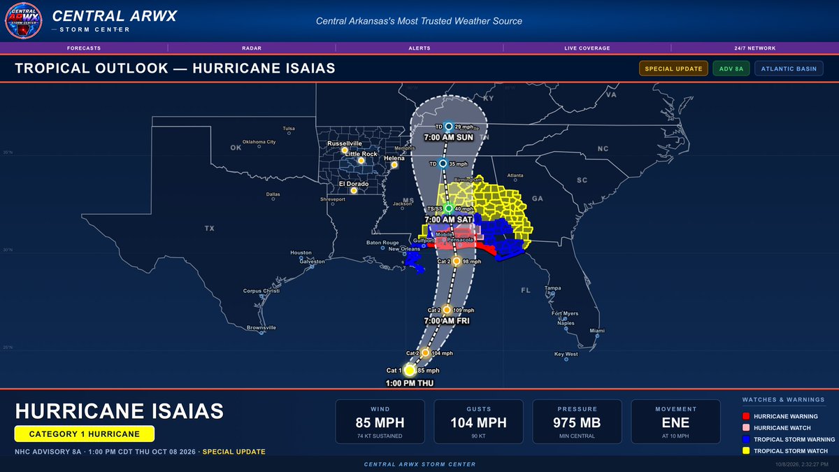
Hurricane Isaias has strengthened into a Category 1 hurricane this afternoon, with sustained winds of 85 MPH, gusts to 104 MPH, and a minimum central pressure of 975 MB.
And yes… the latest track definitely has my attention. 👀
The latest forecast takes Isaias north toward the northern Gulf Coast before weakening inland and moving north through the Lower Mississippi Valley this weekend. The forecast cone now extends into areas just east of Central Arkansas as the system weakens.
⚠️ DO NOT FOCUS ON THE EXACT CENTER LINE.
That line is not an impact line. We’re still a couple of days away from the system reaching this part of the country, and additional shifts east or west remain possible. Even relatively small changes in the track could make a noticeable difference in what we experience across Central Arkansas.
🌧️ RAINFALL: Tropical moisture could become involved in our weekend weather, particularly Saturday into Sunday. Exactly how much rain reaches Central Arkansas will depend heavily on the eventual track.
A farther west track would bring deeper tropical moisture into our area and increase rainfall chances and potential totals. A farther east track would pull the better moisture away from us and could leave much of Central Arkansas with considerably less rainfall.
💨 WIND: This remains one of the bigger things I’m watching for the weekend. Even if the center of Isaias remains east of Central Arkansas, breezy to windy conditions are still expected. How strong those winds ultimately become will depend on the track and resulting pressure gradient.
So for Central Arkansas, the two big questions with Isaias remain pretty simple:
How much tropical moisture gets this far west, and how windy does it get?
And there’s another VERY important distinction with this forecast:
➡️ Isaias and the larger unsettled/pattern-changing system we’re watching next week are TWO SEPARATE SYSTEMS.
Once the tropical system moves away, guidance continues to show another system and front approaching later next week. That could bring another opportunity for rain and storms followed by a potentially much more meaningful change in temperatures.
🌡️ And until then… summer apparently isn’t finished with us. Above-average temperatures continue, with highs climbing back well into the 80s and even around 90° Thursday before changes begin arriving this weekend.
There are still plenty of moving pieces here, and changes to the weekend forecast remain LIKELY. We’re getting into the timeframe where each new round of guidance should help us narrow down the track, wind potential and how far west the meaningful rainfall reaches.
📺 I’ll have much more on Hurricane Isaias and our complete Central Arkansas forecast tonight, including the newest track, weekend wind potential, rainfall chances and the bigger pattern change we’re watching beyond it.
The Central ARWX Weather Network runs 24/7, keeping Central Arkansas covered with forecasts, live radar, alerts, weather updates and live severe weather coverage whenever conditions demand it.
Watch the Central ARWX Weather Network on Roku, YouTube, the website, and the app.
#CentralARWX #ArkansasWeather #CentralArkansas #HurricaneIsaias #TropicalWeather #ARWX
~Lead Forecaster Derek
🌤️ THURSDAY MORNING FORECAST + HURRICANE ISAIAS UPDATE
We’re starting this Thursday morning on the cool side across Central Arkansas, with temperatures generally in the mid to upper 50s. Most spots are sitting between about 54° and 59°, so it’s another comfortable fall morning before temperatures take off later today.
☀️ TODAY: MOSTLY SUNNY & VERY WARM
Sunshine will dominate the forecast today with another big temperature swing from morning to afternoon. Highs will climb into the upper 80s to lower 90s across the area.
Expected highs include around:
91° Morrilton and Conway, 90° Little Rock, Benton, Searcy and Pine Bluff, 89° Perryville, Hot Springs and Sheridan, and 88° Malvern.
So yes… we’re starting in the 50s and ending near 90 again. 😂 Welcome to October in Arkansas.
Conditions remain dry today, but our attention is increasingly turning south toward the Gulf as Hurricane Isaias continues to strengthen and move north.
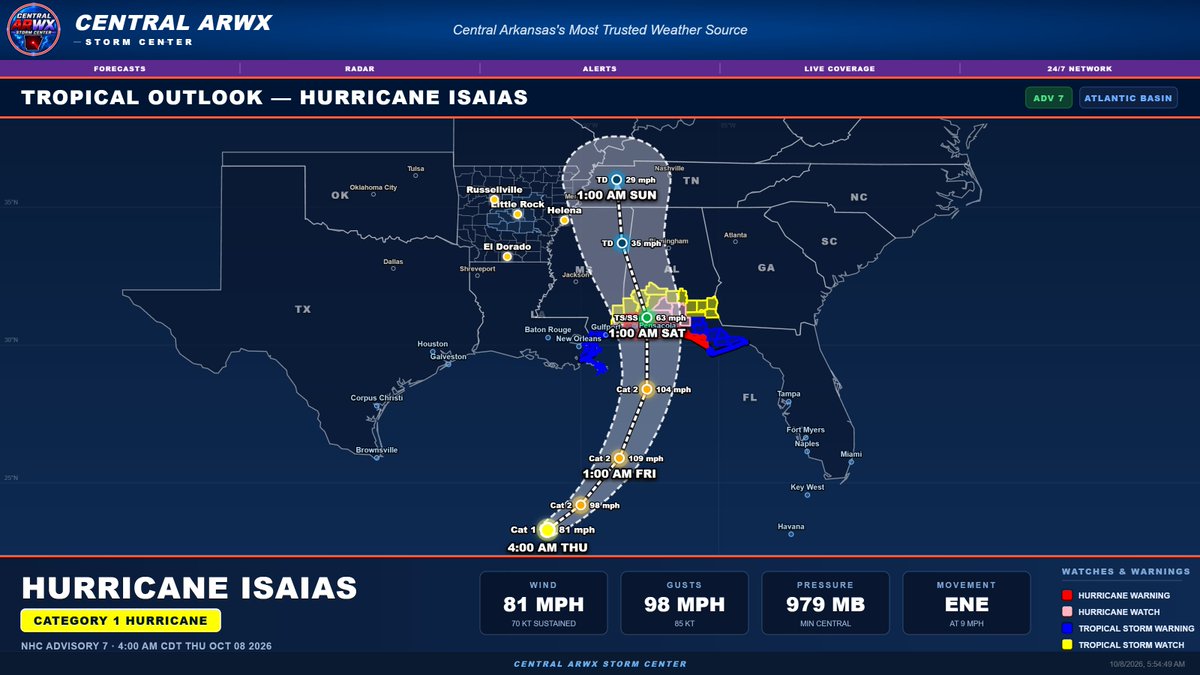
🌀 HURRICANE ISAIAS — ADVISORY 7
As of the latest advisory, Isaias remains a Category 1 hurricane with:
Winds: 81 mph
Gusts: 98 mph
Pressure: 979 mb
Movement: ENE at 9 mph
The forecast continues to bring Isaias northward through the Gulf with additional strengthening possible before the system approaches the northern Gulf Coast late Friday into early Saturday.
One thing I REALLY want everyone to notice on this morning’s graphic is the width of the watches and warnings compared to the forecast track.
⚠️ DO NOT FOCUS ONLY ON THE BLACK TRACK LINE.
The center line is simply the forecast path of the CENTER of the hurricane. It is absolutely not a line showing where impacts stop.
Tropical systems can have a very large wind and rain field, and impacts can occur many miles away from the center. You can see that clearly this morning with watches and warnings extending across a broad portion of the northern Gulf Coast despite the forecast center following a relatively narrow path.
That same principle matters for Arkansas.
🌧️💨 WHAT ABOUT CENTRAL ARKANSAS SATURDAY?
Central Arkansas remains west of the current forecast center track, but some impacts are still very possible Saturday.
Rainfall coverage and amounts remain highly dependent on exactly how far west the moisture shield associated with Isaias expands. Some guidance continues to bring at least scattered showers into portions of Central Arkansas, especially across eastern and central sections.
The more consistent signal continues to be wind.
Even with the center passing east of us, the pressure gradient around the system could produce a noticeably windy Saturday. We’ll continue watching the potential for 20–30 mph sustained winds with gusts approaching 40 mph in spots, depending on the final track and strength of Isaias as it moves inland.
A shift farther west would increase our potential for rainfall, stronger winds and possibly a greater tropical severe-weather concern. A farther-east track would lower those risks.
There are still multiple forecast cycles before those details become locked in, so changes remain likely.
The takeaway this morning:
🌀 Isaias does NOT have to track directly over Central Arkansas to affect us.
💨 Wind remains a concern Saturday.
🌧️ Scattered rainfall remains possible.
📍 Do not judge impacts based solely on the center track.
👀 We continue to watch every update closely.
I’ll have a much more detailed update this evening with the newest track guidance, expected wind field, rainfall potential and what this could mean specifically for Central Arkansas going into the weekend.
📺 The Central ARWX Weather Network remains live 24/7 with forecasts, radar, alerts and severe weather coverage on Roku, YouTube, the website and the Central ARWX PWA App.
#CentralARWX #ArkansasWeather #CentralArkansas #HurricaneIsaias #TropicalWeather #WeekendWeather
~Lead Forecaster Derek
🌙 TONIGHT’S FORECAST + HURRICANE ISAIAS UPDATE
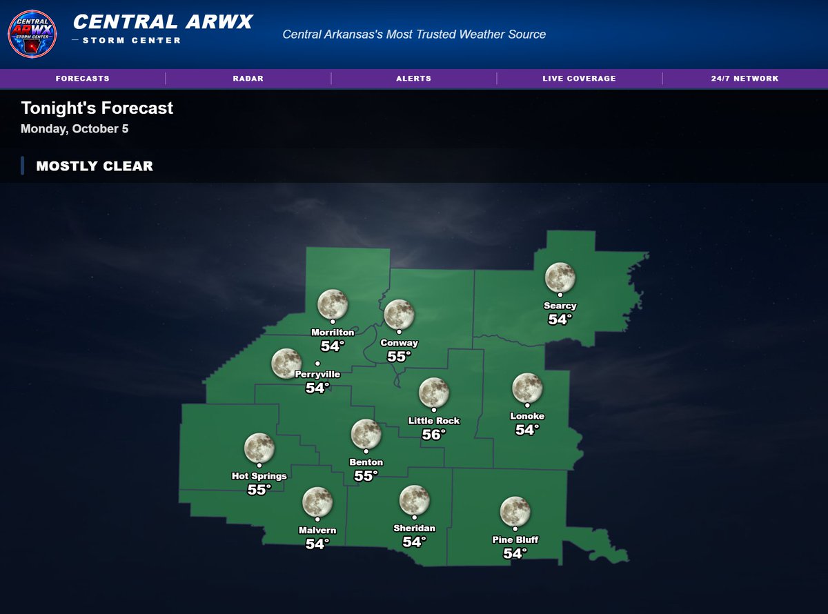
Mostly clear skies are expected across Central Arkansas tonight, with a comfortable start but not quite as cool as the last couple of mornings.
Overnight lows will generally settle into the upper 50s to lower 60s, including around 59° in Benton, Lonoke, Malvern and Pine Bluff, 60° in Conway and Morrilton, 61° in Perryville and Hot Springs, and near 62° in Little Rock and Searcy.
Thursday stays dry and sunny, but the warmth continues to build. Highs are expected to reach around 90° Thursday and 91° Friday in parts of Central Arkansas before attention shifts to the weekend.
💨 SATURDAY STILL LOOKS WINDY
The latest forecast continues to show a windy Saturday, with sustained winds around 20–30 mph and gusts potentially reaching 40 mph. Scattered showers remain possible as tropical moisture approaches, but exactly how much rain reaches Central Arkansas will depend heavily on the eventual track of Isaias.
Sunday currently looks quieter, followed by another warm stretch early next week. Then things become much more interesting late next week as another major front approaches.
⛈️ LATE NEXT WEEK — WATCHING FOR STRONG STORMS
Guidance continues to suggest a more organized storm system arriving around Thursday into Friday of next week, with scattered storms Thursday and a potentially stronger round Friday.
That system could also finally deliver a much more meaningful push of cooler air, with current guidance showing highs potentially falling into the 60s by next Saturday.
There is still plenty of time for those details to change, so this remains something we’ll track closely over the next several days.
🌀 HURRICANE ISAIAS — SPECIAL UPDATE
Isaias is now a Category 1 hurricane, with maximum sustained winds around 75 mph, gusts near 86 mph, and a central pressure near 982 mb.
The current forecast brings Isaias north through the Gulf, with the system potentially strengthening further before approaching the central Gulf Coast Friday night. The latest track then carries the weakening system northward through Alabama and into the Tennessee Valley Saturday.
As always, do not focus solely on the center line. The forecast cone represents uncertainty in where the center may ultimately track, and impacts can extend well outside that line.
For Central Arkansas, the biggest concern remains the system’s western extent.
Even with the center currently projected east of the state, wind will still be a factor Saturday, and tropical moisture could still bring scattered showers into parts of Central Arkansas. A modest westward shift would increase rainfall potential and could also increase the wind threat.
The exact track will continue to determine:
how much rain we receive, how strong the winds become, and whether any isolated tropical-type severe weather threat develops.
At this point, there is no reason to panic — but there is absolutely reason to keep watching.
Forecast changes are still likely as Isaias moves north through the Gulf.
📺 FORECAST VIDEO UPDATE: There will be no video tonight, but regular forecast videos will resume tomorrow evening with the latest on Isaias, the weekend wind/rain potential, and our increasingly interesting late-next-week storm system.
The Central ARWX Weather Network remains live 24/7 with forecasts, radar, alerts and severe weather coverage on Roku, YouTube, the website and the Central ARWX PWA App.
#CentralARWX #ArkansasWeather #CentralArkansas #HurricaneIsaias #Tropics #WeekendWeather
~Lead Forecaster Derek
☀️ WEDNESDAY FORECAST + TROPICAL STORM ISAIAS UPDATE
We start this Wednesday on a cool note across Central Arkansas, with many locations sitting in the low to upper 50s this morning. By this afternoon, though, temperatures climb quickly under mostly sunny skies.
Highs today will generally reach the mid to upper 80s, including around 86° in Little Rock, 87° in Conway, Benton, Sheridan and Pine Bluff, and 85° in Perryville. So yes, it will feel much more like late summer than early October again this afternoon.
The quiet weather continues locally today, but attention remains focused on the Gulf after Tropical Storm Isaias officially formed.
🌴 TROPICAL STORM ISAIAS
Isaias currently has sustained winds around 40 mph and is moving generally east-northeast around 8 mph. Forecast guidance continues to strengthen the system over the Gulf before bringing it north toward the central Gulf Coast later this week.
One thing I want to stress: do not focus on the exact center line of the forecast track.
The cone represents where the center of the storm could track, and impacts can extend well away from that center. Small shifts in the track over the next several days could make a meaningful difference in what Arkansas ultimately experiences.
For Central Arkansas, this system still bears watching closely.
Some guidance continues to bring at least showers and tropical moisture into parts of the area this weekend, while other solutions keep the heavier moisture farther east. That part of the forecast is still very much dependent on the final track.
💨 WIND REMAINS A CONCERN REGARDLESS
Even if the heaviest rain stays east of us, we could still see a noticeably windy weekend as the pressure gradient tightens around the system.
At this point, gusts in the 30–40 mph range remain possible depending on how close the circulation tracks to Arkansas.
Rainfall chances, wind strength, and any potential for an isolated tropical-type tornado threat will all depend heavily on the eventual path of Isaias.
🌧️ WEEKEND RAIN CHANCES ARE NOT ZERO
I would not write off rain for Central Arkansas just because the current track has shifted some.
There is still data showing at least scattered showers reaching parts of the area this weekend, particularly if the moisture shield spreads farther west than currently projected. We’ll continue adjusting those probabilities as confidence improves.
The takeaway right now is simple: the forecast is still evolving.
We are several days away, the track can still move, and tropical systems are notorious for making relatively small adjustments that produce much larger differences in local impacts.
I’ll continue tracking Isaias closely and will have updated information as new guidance arrives.
📺 The Central ARWX Weather Network remains live 24/7 with forecasts, radar, alerts and severe weather coverage on Roku, YouTube, the website and the Central ARWX PWA App.
#CentralARWX #ArkansasWeather #CentralArkansas #TropicalStormIsaias #Tropics #WeatherUpdate
~Lead Forecaster Derek
🌴 WATCHING THE TROPICS — BIG CHANGES POSSIBLE THIS WEEKEND AND BEYOND
We have a lot to talk about tonight as the weather pattern across Central Arkansas looks to become much more active over the next several days. The first part of the forecast is pretty straightforward: summer-like warmth is sticking around for a few more days, with highs climbing well into the 80s and some locations pushing near 90° by Thursday. After the cool mornings we’ve had lately, those afternoons are going to feel pretty warm again.
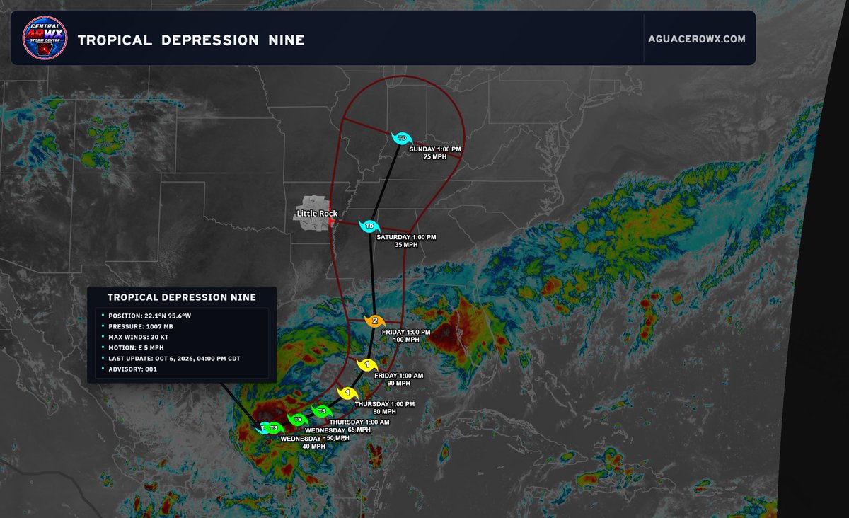
The bigger question comes as we head toward the weekend, and that centers around Tropical Depression Nine. The system is currently over the western Gulf and is expected to strengthen as it moves northward. The exact track remains very important because even relatively small shifts east or west could make a noticeable difference in what Central Arkansas experiences.
At this point, the tropical system and the larger unsettled pattern expected next week are two separate systems. The tropical moisture could influence our weather this weekend depending on the eventual track, while another system later next week looks capable of bringing a more significant pattern change.
🌧️ WEEKEND RAIN CHANCES
Rainfall remains one of the biggest forecast uncertainties. Current guidance generally shows the better moisture axis favoring portions of eastern and southeastern Arkansas, but that could easily shift as the tropical track becomes clearer.
Right now, rainfall projections across Central Arkansas range from only a few tenths of an inch in some areas to around 0.50–0.75" farther east, with locally higher totals possible if the tropical moisture plume shifts farther west.
That means this is absolutely not a locked-in widespread heavy rain event for everyone. Some areas may receive beneficial rainfall, while others could again end up on the lower side of totals.
💨 WIND MAY BE THE MORE CONSISTENT IMPACT
Regardless of how much rain actually reaches Central Arkansas, the pressure gradient around this system could make the weekend noticeably windy.
At this point, we are watching the possibility of winds gusting into the 30–40 mph range, especially if the system tracks close enough to Arkansas. The exact magnitude will depend heavily on track and strength, but even a drier solution could still produce a windy weekend.
🌪️ ISOLATED TORNADO RISK?
This is another part of the forecast that will depend almost entirely on the eventual track.
If deeper tropical moisture and the stronger wind field move far enough west, there could be at least some potential for low-topped rotating showers or isolated tornadoes, especially closer to the eastern side of the system’s circulation.
That is not something we are sounding alarms about right now, but it is absolutely something that needs to be watched as the track becomes better defined.
🌊 FLOODING CONCERNS
A marginal excessive rainfall risk currently reaches parts of eastern Arkansas later in the period. Again, the western extent of the heavier rainfall corridor remains uncertain.
If repeated bands of tropical moisture move across the same areas, localized flooding could become possible. Right now, though, the greatest concern appears more likely to remain east of much of Central Arkansas unless the track shifts west.
🔥 BEFORE ALL OF THAT — SUMMER RETURNS… AGAIN
Wednesday through Friday looks mostly dry and increasingly warm.
Highs are expected to climb from the mid 80s Wednesday into the upper 80s to near 90° Thursday and Friday. Yes… apparently October has decided summer still gets a few more shifts before clocking out. 😂
Humidity should gradually increase as moisture begins returning northward ahead of the weekend system.
🥶 THEN COMES THE BIGGER PATTERN CHANGE
Once we get beyond the tropical system, attention turns to a separate and potentially stronger front later next week.
Current guidance continues to advertise a much more substantial push of colder air toward the region near the end of the extended forecast period. If that verifies, we could finally be talking about the coldest air of the season so far, along with another round of rain and storms ahead of the front.
The extended precipitation outlook is also trending wetter across the region, which is encouraging considering how stubborn the drought conditions have been.
The exact timing remains uncertain this far out, but the overall pattern is becoming much more interesting.
📌 BOTTOM LINE
We have several moving pieces over the next 7–10 days:
Summer-like warmth returns through the end of the workweek.
Tropical Depression Nine could influence Arkansas weather this weekend.
Track will determine how much rain reaches Central Arkansas.
Winds may gust 30–40 mph even if rainfall remains limited.
An isolated tornado threat cannot be ruled out if the system tracks favorably for deeper tropical moisture.
A separate storm system/front could bring another round of rain and storms next week.
The coldest air of the season so far may arrive behind that front.
There are still plenty of details that will change between now and the weekend, especially with the tropical track. Changes are likely, so do not lock onto any single model run or exact rainfall total yet.
We’ll continue updating the forecast nightly as the picture becomes clearer.
📺 The Central ARWX Weather Network remains live 24/7 with forecasts, radar, alerts and severe weather coverage on Roku, YouTube, the website and the Central ARWX PWA App.
#CentralARWX #ArkansasWeather #CentralArkansas #Tropics #Arkansas #WeatherUpdate
~Lead Forecaster Derek
Keeping my eye on this very closely. Once we get Isaias out of the way, attention will turn to next weeks big cold front. I will have more coming up on this in a late edition forecast coming up here around 11. It has been an evening but thank you for sticking with me! ~Derek #arwx
🌀 TROPICAL DEPRESSION NINE — QUICK UPDATE
Tropical Depression Nine continues to organize in the western Gulf, with the current forecast bringing the system northward toward the Gulf Coast later this week before lifting inland.
For Central Arkansas, the big question remains how far west or east the eventual track shifts. That will play a major role in how much tropical moisture reaches us and what kind of impacts we could see over the weekend.
At this point, possible weekend effects could include increasing clouds, gusty winds, periods of rain, and potentially a few stronger storms depending on the exact track and how the system interacts with the broader pattern. There is still plenty of time for changes, so this is absolutely not a locked-in forecast yet.
I’ll have a much more detailed update tonight, including the latest track trends and what Tropical Depression Nine could mean for our weekend weather here in Central Arkansas.
#CentralARWX #ArkansasWeather #TropicalUpdate #CentralArkansas #Tropics
~Lead Forecaster Derek
☀️ COOL START, WARM FINISH FOR YOUR TUESDAY
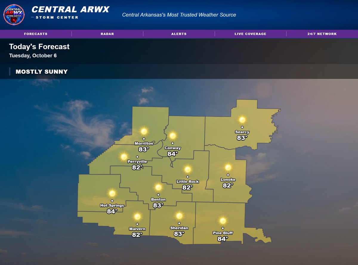
It’s a crisp start across Central Arkansas this morning, with temperatures mainly in the low to upper 50s. A few of the coolest spots are near 52° around Russellville, Morrilton and Greenbrier, while Little Rock is sitting near 58°.
After the cool start, we’ll warm up quickly under mostly sunny skies. Highs this afternoon will climb into the low to mid-80s, with most locations topping out around 82–84°.
Humidity stays relatively low, so even with the warmer afternoon temperatures, it should still feel pretty comfortable compared to what we dealt with through much of September.
The quiet pattern continues for now, but we’ll keep watching the weekend closely as tropical moisture and stronger winds could begin to influence the region. Expect continued updates as that setup becomes clearer.
📺 The Central ARWX Weather Network remains live 24/7 with forecasts, radar, alerts and weather updates on Roku, YouTube, https://t.co/oVZP5VMBfQ and the Central ARWX PWA App.
#CentralARWX #ArkansasWeather #CentralArkansas #TuesdayForecast #FallWeather
~Lead Forecaster Derek
🌤️ COOL MORNINGS, WARM AFTERNOONS — BUT THE WEEKEND FORECAST IS GETTING INTERESTING
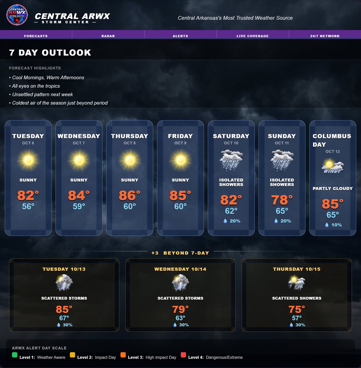
Central Arkansas will stay in a fairly quiet early-fall pattern through much of the workweek, with cool mornings, plenty of sunshine, and warmer-than-average afternoons.
Tonight will be mostly clear with lows falling into the mid-50s for most of the area. Tuesday through Friday looks mainly sunny, with highs gradually climbing from the lower 80s into the mid-80s by late week.
🌴 Our attention then turns to the tropical system this weekend. This is separate from the more unsettled weather pattern showing up next week. How much tropical moisture reaches Arkansas will depend heavily on the eventual track of that system, and that track will also have a major influence on rainfall amounts, wind strength, and whether any isolated tornado threat develops.
💨 One thing looks increasingly likely regardless of rainfall: it is going to be windy. Current guidance supports winds potentially pushing 30–40 mph at times this weekend, so even areas that do not see much rain could still feel the effects of the system.
🌧️ Rain chances for the weekend remain highly track-dependent. A farther west track would likely bring more moisture and potentially a greater severe-weather component into the region, while a farther east track could significantly reduce rainfall totals. That is why confidence in the exact details is still limited.
⚠️ Current guidance remains very interesting, and changes are LIKELY. This is not a forecast we expect to stay perfectly locked from run to run, so keep checking back for the nightly updates as the track becomes clearer.
Then beyond the tropical system, we’re watching a separate unsettled pattern next week, along with signs that the coolest air of the season so far may arrive later in the period.
📺 Watch the Central ARWX Weather Network 24/7 for forecasts, radar, alerts and updates on Roku, YouTube, https://t.co/oVZP5VMBfQ and the Central ARWX PWA App.
#CentralARWX #ArkansasWeather #CentralArkansas #TropicalWeather #WeekendWeather #WeatherUpdate
~Lead Forecaster Derek
As I mentioned last night, all eyes are on the Gulf and what will become our next named storm. The question of the day will be is will this affect Arkansas. There is A LOT to work out with this system. I will have more coming up in your forecast around 930. #arwx
☀️ MONDAY FORECAST — A BEAUTIFUL FALL START!
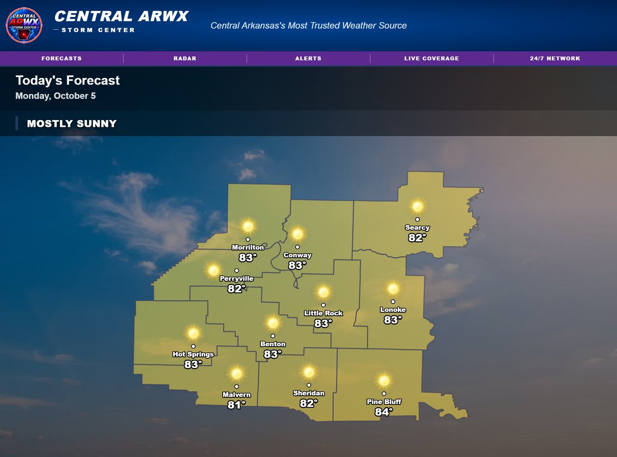
We’re waking up to a genuinely nice fall morning across Central Arkansas, with temperatures mostly in the mid to upper 50s. A few spots are a little cooler, including Arkadelphia near 54°, while areas farther south are closer to 59–60°.
By this afternoon, we warm up quickly under mostly sunny skies. Highs will generally reach the low to mid 80s, with most locations around 82–83° and Pine Bluff near 84°.
The good news: humidity stays much more comfortable, so even though temperatures are running a little warm for October, it should still feel pretty nice overall.
This is the pattern we’ll see much of the week — cool, fall-like mornings followed by warmer-than-average afternoons.
📺 The Central ARWX Weather Network remains live 24/7 with forecasts, radar, alerts and severe weather coverage on Roku, YouTube, the website and the Central ARWX PWA App.
#CentralARWX #ArkansasWeather #CentralArkansas #FallWeather #MondayForecast
~Lead Forecaster Derek