Thursday and Friday both look like the warmest days of the week area wide before a cool down begins.
The hottest weather will be in the deserts and Imperial County with afternoon temperatures in the low 100s. #Sandiegocountywx#Imperialcountywx
TROPICS: Tropical Storm Amanda has formed in the Eastern Pacific becoming the first named storm of Eastern Pacific Hurricane Season. Amanda will likely head NW the next couple of days before turning west by Friday while maintaining TS strength. There is no threat to any land.
There are two other AOI's in the Eastern Pacific with a a low to medium chance of development as low pressure forms in these regions. The southern most AOI off the coast of Central America has a little more favorable environment for development. So far no threat to land with these two either. #Tropics #Tropicalupdate #Socalwx
TONIGHT: Cold tonight as lows range from the upper 30s to low 60s across San Diego and Imperial County. A passing storm system will keep overnight temperatures cooler than normal.
WIND CHILL: Feels like temperatures tonight in the San Diego County mountains will fall into the middle and upper 20s for most spots. BRRR. #Sandiegocuontywx #Imperialcountywx
With winds remaining high through Thursday, blowing dust will continue to reduce both air quality and visibility across Imperial County.
Even as winds gradually decrease, expect periods of blowing dust to continue through the end of the week. #imperialcountywx
TUESDAY PM: As low pressure passes to the north, strong winds will continue across the San Diego County mountains and desserts & through much of Imperial County.
A Wind Advisory remains in effect for these locations through Thursday morning for the potential of gusts as high as 50 mph.
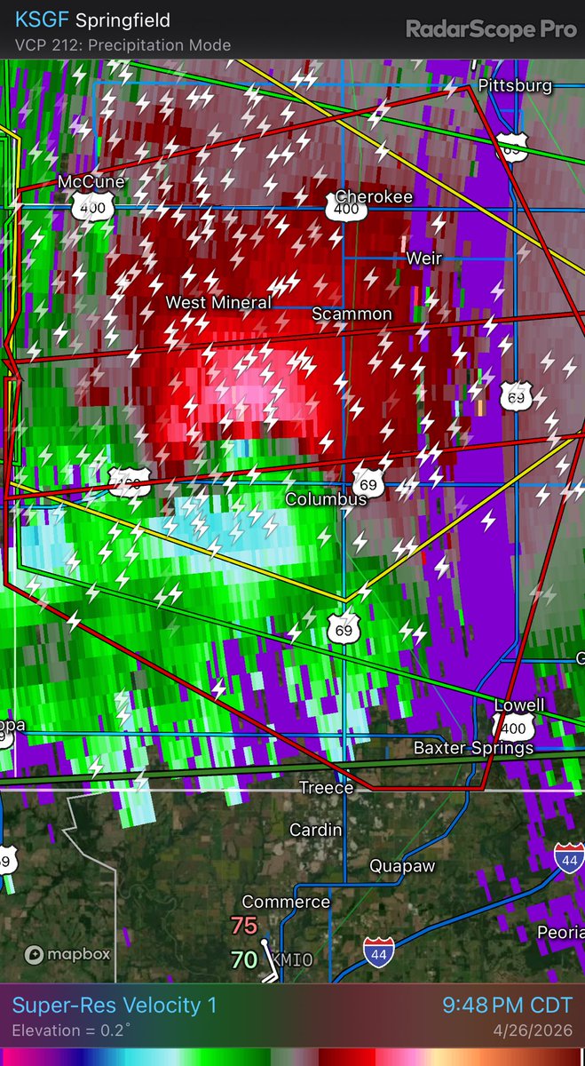
15 YEARS: Tomorrow marks a decade and a half since the Joplin, Missouri EF5 tornado. My story is just one of thousands from that day, but it left a profound impact on me that I’ll carry with me for the rest of my life.
In a twist of fate I’ll never truly understand, I ended up in Joplin just hours before the tornado on that dark May afternoon. Experiencing the destruction and human impact of the storm gave me a new perspective and respect for the power of Mother Nature. My passion for weather has never been stronger, and I’m excited to continue sharing it with you through some new projects in the coming months.
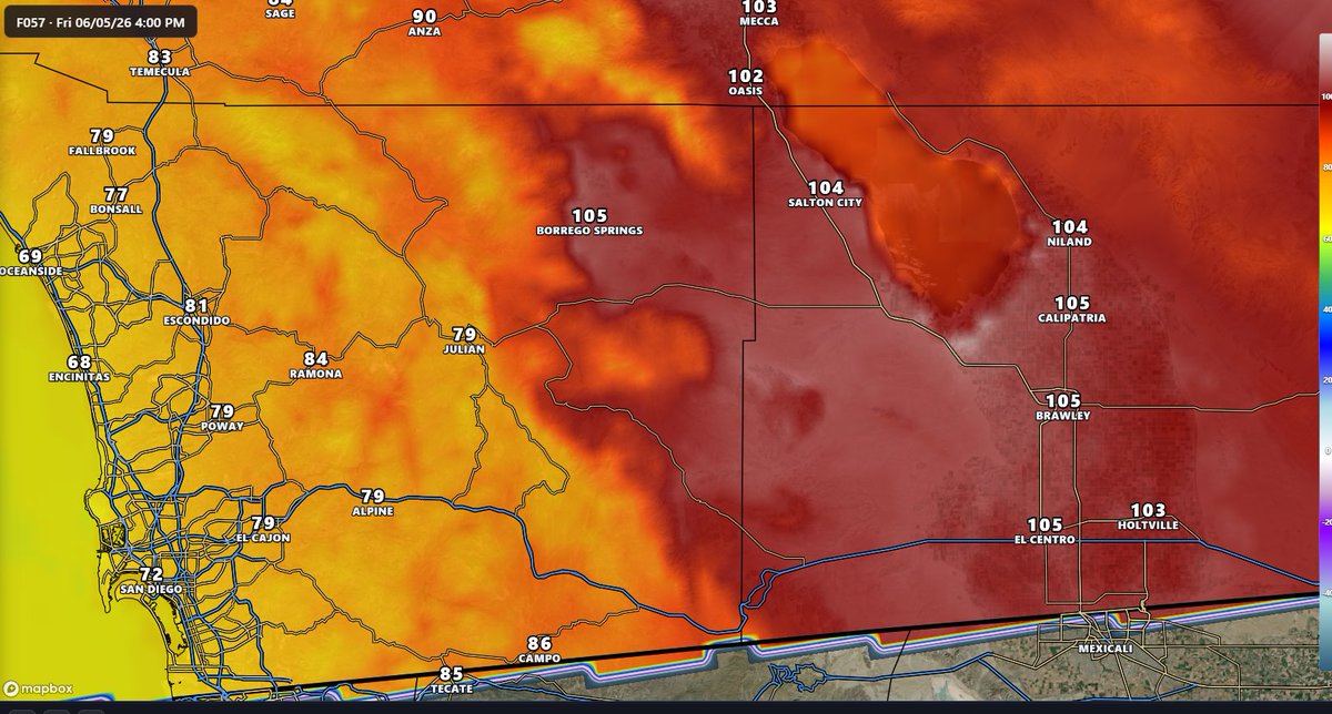
Scorching heat is on the way. Extreme Heat Watch begins Sunday and continues into early next week for the San Diego County desserts and western Imperial County. Highs as hot as 112 degrees are expected Monday and Tuesday in the watch area. #Sandiegocountywx#Imperialcountywx
EXCESSIVE HEAT: As our storm system from yesterday pulls away, all eyes turn to some very hot weather moving in over the weekend.
A ridge high pressure will build over the coming days, and by Sunday & Monday highs will rage from the 90s in the valleys, 80s in the mountains, and triple digit heat in the desserts and in Imperial County. After the heat peaks, we still stay warm through next week. #Sandiegocountywx #Imperialcountywx
ACTIVE NEXT WEEK: Latest guidance from the CPC is suggesting a 60-70% chance of above normal rainfall next week across our entire area.
Keep in mind this map doesn’t depict how much rain will fall or how heavy it will be, but gives an idea that precip chances are possible, especially around the middle of next week. #socalwx #sandiegowx #Imperialcountywx
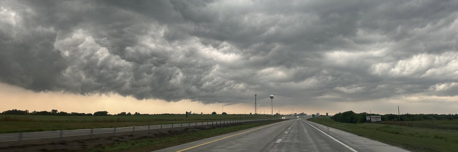
Watching the weather in Midwest. I do not trust this storm in SE KS. Not one bit. Had a history of producing tornadoes before outflow briefly undercut updraft, followed by a brief messy storm merger. Now riding right a long the warm front with a strengthening LLJ and curved hodographs. Look at surface OBS with favorable backed winds near Joplin. Watch this one.
Watching the weather in Midwest. I do not trust this storm in SE KS. Not one bit. Had a history of producing tornadoes before outflow briefly undercut updraft, followed by a brief messy storm merger. Now riding right a long the warm front with a strengthening LLJ and curved hodographs. Look at surface OBS with favorable backed winds near Joplin. Watch this one.
Latest drought monitor now includes much of San Diego County and Imperial County in the “Abnormally Dry” category. Despite an active winter many spots are still in a rainfall deficit #sandiegowx#Imperialcountywx
Wind Advisory for San Diego County desserts and much of Imperial County beginning tomorrow afternoon through Sunday morning. Gusts as high as 55 mph expected across the advisory area. #sandiegowx#Imperialcountywx
The terrifying view of the tornado near Enid, Oklahoma this evening as it crossed the road. Join our live streams & watch the full chase edit coming up via https://t.co/nieJn2YwxP
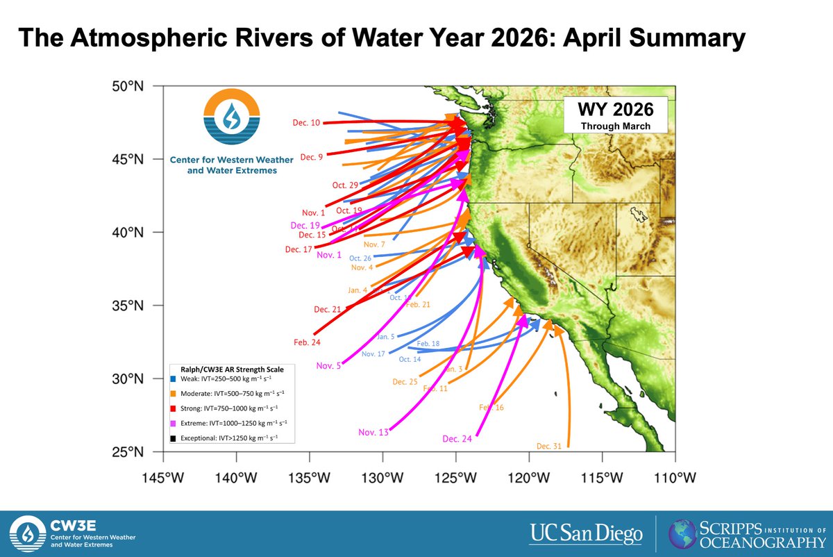
56 #AtmosphericRivers made landfall along the U.S. West Coast during the first 6 months of Water Year 2026. Stark differences in AR activity between October-December (14 strong or greater ARs) and January-March (only 3 strong ARs) helped explain the anomalously wet/dry conditions during those periods.
Read the full summary here: https://t.co/wavv0waI7k.