Shortly before 10 a.m. today, outdoor warning sirens in Wheaton and some other DuPage County areas activated in error. There is no severe weather in the area. DU-COMM is currently investigating the cause and apologizes for the confusion.
There is an increasing threat that an intense organized line of storms capable producing destructive winds in excess of 80 mph in impact the area Tuesday between 9am and 3pm. Stay tuned for forecast updates! #ILwx#INwx
City of Wheaton crews will be doing a citywide pickup of tree damage. Place tree limbs/branches at the curb for pickup by 7am Mon. to have items picked up. Crews will make one pass through the community. https://t.co/Zm8Fq7hQUu
The National Weather Service issued a Severe Thunderstorm Warning until noon for Wheaton with possible hail and wind damage. Take precautions and head indoors to an interior room.
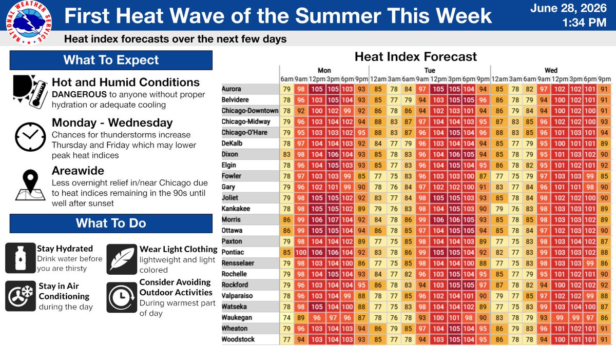
The @NWSChicago issued a Heat Advisory from noon Mon. to 10 pm Wed., with a heat index over 100 degrees each afternoon.
Take precautions to keep yourself & loved ones safe:
Drink plenty of fluids
Stay in an air-conditioned room
Stay out of the sun
Check on relatives & neighbors.
A stretch of dangerous heat will begin tomorrow. Expect late morning and afternoon heat indices as high as around 105° through at least Wednesday. Make sure you're taking precautions over the next few days to stay cool! #ILwx#INwx
(🧵1/4)
The National Weather Service issued a Severe Thunderstorm Warning for DuPage County until 4:30 p.m. June 10, with considerable tree damage posible due to wind gusts up to 70 mph. Have multiple ways to receive updates and be alert for the potential of a tornado developing.
UPDATE: Harrison Avenue between Santa Rosa and Irving Avenue has been reopened to traffic following a temporary closure for a downed power line. Thank you for your patience.