Better forecasts, practical climate tools & products plus producer case studies. These have all been the result of 2 projects instrumental in putting climate forecasting at the fingertips of farmers. Read more about the achievements of #MCV & #FWFA here: https://t.co/rshQUBQ26b
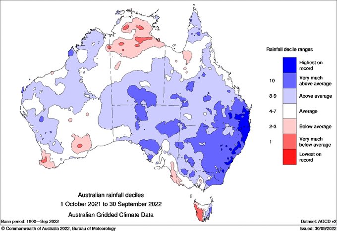
It was the second-wettest spring on record for Australia behind only 2010 and the coolest spring since 2010. Almost all of Aus had above average rainfall except parts of #WA and western #TAS and most of the southern mainland had below average temperatures: https://t.co/4TP4WjCBCK
What happens when #workingdogs are let of the leash? Well, in some instances not much but other times they can run absolutely wild. And this is exactly what the #climatedogs have been doing in 2022! Read what ENSO, Indy, Sam & Mojo have been up to here: https://t.co/xbFdn2slta
Did you know that rivers can occur not just on the earth but in the sky too? These are known as atmospheric rivers & they contribute to 20-35% of SE Aus & 10-20% of SW Aus annual rainfall. They can however also be quite disastrous. Find out how here: https://t.co/qNd6C0TuUh
The warming trend outlined in previous State of the Climate reports is continuing. Australia is experiencing climate change now with impacts felt by many communities. Find out more here: https://t.co/GD0upPpCvZ
#SotC2022#weather#climate#CSIRO
So how good are the seasonal forecasts? Well a form guide to understand how good or skillful a seasonal #forecast is for a region and season of interest has been developed by @CSIRO. Read about the AgScore software here: https://t.co/j6oPE4CJid #climate
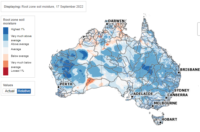
CottonInfo Moisture Manager - a cooler summer outlook and El Niño now in the conversation for 2023. Plus, rain and temp deciles, new FWFA product tour and much more #agchatoz - https://t.co/gLS0e8uB46
Although La Niña is in the spotlight right now with a rare 3-in-a-row event underway, @BOM_au wet outlooks for the rest of the year reflect not only La Niña, but also a number of climate drivers.
Read more: https://t.co/qNgGsHl4IH
Read how budgeting across deciles offers insights into the upside and downside of a risky decision and how a simple spreadsheet can be used to help make Rapid Climate Decisions: https://t.co/XH7NV9RNUc #PeterHayman#BarryMudge@SA_PIRSA
Learn about a form guide for SCFs, the flavours of ENSO & how budgeting across deciles can help with #climate risky decisions. All this & more in the latest edition of Climate Kelpie News out now! #extermeclimate#FWFA https://t.co/19l8tjm12N
“This tool helps me with budgeting... these tools are another step in improving the accuracy of my decisions. I can use the stars at the top of the decile bars + box & whisker plots..." Read how dairy farmer Wayne Clarke uses #FWFA@BOM_au climate tools: https://t.co/HdThR9Olpc
So you've heard of 'mixed herbs' but have you heard of a #ENSOModoki flavour? OK, OK, no surprise we are talking climate! Scientists have been discovering that El Niño & La Niña events are not all the same and that they tend to have a ‘flavour’. Read more https://t.co/vrmHXd7rCr
Above average rainfall is likely across eastern states over coming months reflecting the influence of several key climate drivers including a persisting #LaNiña and a negative Indian Ocean Dipole event. Learn more in our Climate Driver Update: https://t.co/FMwRFTEnCH
November to January rainfall is likely to stay above average for the eastern half of Australia. Warmer days are likely in the west and Tasmania, while cooler days are likely for large parts of eastern Australia. Learn more: https://t.co/t0sFNJQyxx
Last 12 months rainfall shows many areas of highest-on-record (since 1900) in SE Australia, but bottom 10% (decile 1) in NT & western facing coastlines of southern Australia.
A complex combination of negative IOD, La Niña, positive SAM, MJO, Climate Change + more. #NotJustLaNina
The Climate and Water Outlook for August to October indicates a high chance of above average rainfall remains for the eastern half of Australia. Any further rain increases the flood risk, particularly in eastern Australia.
Learn more: https://t.co/h1tx8iNF6g
#LaNiña is underway and the negative Indian Ocean Dipole (#IOD) event continues.
When these conditions combine, the likelihood of above average rainfall over Australia is further increased, particularly for the eastern half of the country: https://t.co/pSFVyo9npP
CottonInfo Moisture Manager - third consecutive La Niña now officially here. Plus, current conditions, seasonal model survey for Oct-Nov-Dec and much more. #agchatoz - https://t.co/XTCPY91U9M
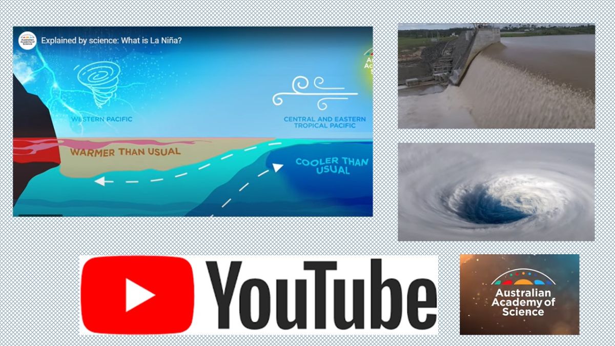
A nice #LaNina explainer video from the Australian @Science_Academy about how the Pacific ocean and atmosphere reinforce each other to create a 'locked-in' pattern. (With cameos from me...)
A #LaNiña event is underway in the Pacific Ocean. The Bureau's 3-month climate outlook shows a high chance of above-average rainfall for the eastern half of Australia. La Niña is not the only driver influencing this wet outlook. Learn more - https://t.co/Sxi7noGXVN