10:35 AM EXTENDED FORECAST - We'll keep the active pattern rolling over the next several days, though uncertainty still remains in regards to the exact timing and coverage of showers and storms! We break it all down in this morning video forecast! #ARwx#NWANews
I.E…we just looked at the RPI ranking (a flawed, outdated metric), ignored H2H/ Quad 1 records and called it a day.
Get someone who loves the game of baseball on the committee PLEASE. #WPS
Dramatic new footage of the violent Saint Libory, Nebraska tornado as it destroys homes and the search and rescue immediately after the event. Amazingly no fatalities or injuries occurred! #new#tornado@JordanHallWX@SevereStudios@Unitedcajunnavy
Chasing in #Arkansas expectations:
1. Trees and hills in NW half of state.
2. Most events are nocturnal.
3. QLCS events are more common.
4. Predicted events seem to under perform and unpredicted over perform.
5. Road networks are trash.
Best advice is to wait and chase elsewhere.
27 years ago today, one of the largest #tornadoes ever, made a terrifying path through the #OKC metro. My location was the blue X located near I-35 and I-240. I filmed it as it passed just south of me. #OKWX#F5
Severe thunderstorm rolling over #Springdale#ARWX earlier today. This storm dropped quite a bit of hail with reports of up to 3” in size, I saw hail around the 1.5” range just to the west in Elm Springs
[8 AM - 4/28/2026] - We have ONE MORE severe weather risk for the area this late morning into the early evening. I know we’ve seen a lot of storm chances with very little in the way of storm activity the last couple of days in our area, but storms just barely missed our area to the north on Sunday and they were just to our east on Monday.
For today… I do believe we’ll see more storms than we have the last couple of days. All hazards will be possible as we have an ENHANCED risk of severe weather.
Timing graphics have been included for Fort Smith and Fayetteville.
Hail is the greatest threat, but tornadoes (some strong EF2+) cannot be ruled out.
Please remain weather aware for this afternoon into the evening. Storms will be a lot earlier and will be during daylight hours. Josh will have more updates later today and I’ll be in early to get ready to cover storms. We’ll be providing live streaming as storms start to threaten the area. #arwx
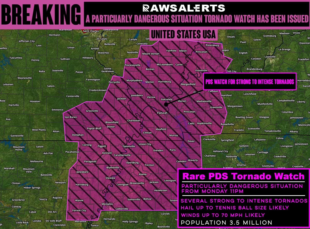
🚨#BREAKING: A Rare Dangerous Situation (PDS) Tornado Watch issued as an extremely dangerous and life-threatening tornado outbreak is likely today across parts of the Midwest
📌#Unitedstates | #USA
The National Weather Service has issued an extremely rare Particularly Dangerous Situation (PDS) Tornado Watch, alongside a Moderate Risk outlook, signaling the potential for a significant and potentially catastrophic tornado outbreak today. Numerous large, long-track, and extremely violent tornadoes are possible across portions of Arkansas, Illinois, Indiana, Kentucky, Missouri, and Tennessee. This is a life-threatening situation with the potential for widespread destruction. If you are in or near these areas, take immediate action now. Review your safety plan, identify your shelter location, and be prepared to act without hesitation if warnings are issued. Conditions are favorable for rapidly developing, dangerous storms that could escalate quickly. This level of alert is rare
MiniCOW packs MegaPOWER! Observes birth and ingestion of satellite tornado
and Fujiwara effect deflecting tornado. Tornado transitions 2x between clear eye and debris ball. Prelim data from most powerful mobile radar, 1 MegaWatt C-band storm-penetrating miniCOW in Braman, OK 🌪️
The terrifying view of the tornado near Enid, Oklahoma this evening as it crossed the road. Join our live streams & watch the full chase edit coming up via https://t.co/nieJn2YwxP


![weatherdan's tweet photo. [8 AM - 4/28/2026] - We have ONE MORE severe weather risk for the area this late morning into the early evening. I know we’ve seen a lot of storm chances with very little in the way of storm activity the last couple of days in our area, but storms just barely missed our area to the north on Sunday and they were just to our east on Monday.
For today… I do believe we’ll see more storms than we have the last couple of days. All hazards will be possible as we have an ENHANCED risk of severe weather.
Timing graphics have been included for Fort Smith and Fayetteville.
Hail is the greatest threat, but tornadoes (some strong EF2+) cannot be ruled out.
Please remain weather aware for this afternoon into the evening. Storms will be a lot earlier and will be during daylight hours. Josh will have more updates later today and I’ll be in early to get ready to cover storms. We’ll be providing live streaming as storms start to threaten the area. #arwx](https://pbs.twimg.com/media/HG_rPpjagAAn1LX.jpg)
![weatherdan's tweet photo. [8 AM - 4/28/2026] - We have ONE MORE severe weather risk for the area this late morning into the early evening. I know we’ve seen a lot of storm chances with very little in the way of storm activity the last couple of days in our area, but storms just barely missed our area to the north on Sunday and they were just to our east on Monday.
For today… I do believe we’ll see more storms than we have the last couple of days. All hazards will be possible as we have an ENHANCED risk of severe weather.
Timing graphics have been included for Fort Smith and Fayetteville.
Hail is the greatest threat, but tornadoes (some strong EF2+) cannot be ruled out.
Please remain weather aware for this afternoon into the evening. Storms will be a lot earlier and will be during daylight hours. Josh will have more updates later today and I’ll be in early to get ready to cover storms. We’ll be providing live streaming as storms start to threaten the area. #arwx](https://pbs.twimg.com/media/HG_rPpYbMAAVNXf.jpg)
![weatherdan's tweet photo. [8 AM - 4/28/2026] - We have ONE MORE severe weather risk for the area this late morning into the early evening. I know we’ve seen a lot of storm chances with very little in the way of storm activity the last couple of days in our area, but storms just barely missed our area to the north on Sunday and they were just to our east on Monday.
For today… I do believe we’ll see more storms than we have the last couple of days. All hazards will be possible as we have an ENHANCED risk of severe weather.
Timing graphics have been included for Fort Smith and Fayetteville.
Hail is the greatest threat, but tornadoes (some strong EF2+) cannot be ruled out.
Please remain weather aware for this afternoon into the evening. Storms will be a lot earlier and will be during daylight hours. Josh will have more updates later today and I’ll be in early to get ready to cover storms. We’ll be providing live streaming as storms start to threaten the area. #arwx](https://pbs.twimg.com/media/HG_rPpDWsAAT2_7.jpg)


![weatherdan's tweet photo. [8 AM - 4/28/2026] - We have ONE MORE severe weather risk for the area this late morning into the early evening. I know we’ve seen a lot of storm chances with very little in the way of storm activity the last couple of days in our area, but storms just barely missed our area to the north on Sunday and they were just to our east on Monday.
For today… I do believe we’ll see more storms than we have the last couple of days. All hazards will be possible as we have an ENHANCED risk of severe weather.
Timing graphics have been included for Fort Smith and Fayetteville.
Hail is the greatest threat, but tornadoes (some strong EF2+) cannot be ruled out.
Please remain weather aware for this afternoon into the evening. Storms will be a lot earlier and will be during daylight hours. Josh will have more updates later today and I’ll be in early to get ready to cover storms. We’ll be providing live streaming as storms start to threaten the area. #arwx](https://pbs.twimg.com/media/HG_rPpmasAEIl_Q.jpg)