Now tagged as a 10% area by @NHC_Atlantic, some chance exists for a brief tropical depression to form later this week in the western Gulf as the remnants of Tropical Storm Cristina combine with a tropical wave/trough crossing the Yucatan Peninsula. Elevated wind shear will leave the system with little time to consolidate prior to moving westward into Mexico, so chances for a significant storm look low.
I've updated my NMME plots with the June 2026 run.
Overall idea remains the same, strong El Nino event is expected heading into Fall/Winter.
This months run is slightly warmer than last month, where Nino 3.4 peaks at +2.77C even with the global mean SSTA removed!
I've made an NMME version of the global mean anomaly charts going throughout hurricane season.
Noticeably warmer El Nino signal compared to the CanSIPS, with Nino 3.4 global mean anomalies exceeding +2°C by September and peaking near +2.5°C by November.
@phillywxguy_ One note about the CanSIPS on TropicalTidbits - It uses an outdated climatology.
When put against the modern 1991-2020 climatology the El Nino signature is vastly different.
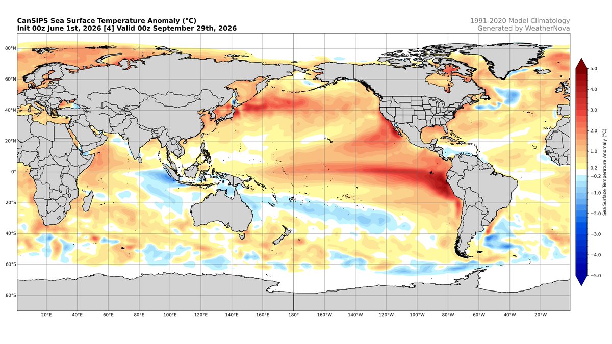
I've now plotted the June CanSIPS run, the only difference in the maps being a broader scale (-5 to +5 now instead of -3 to +3).
Nothing major has changed this month, but the El Nino has trended slightly stronger, reinforcing the idea of an active Pacific basin this year.
The plots I made before had an error in the climo period, but that issue has been fixed and the full May CanSIPS run (SSTAs and global mean) is included.
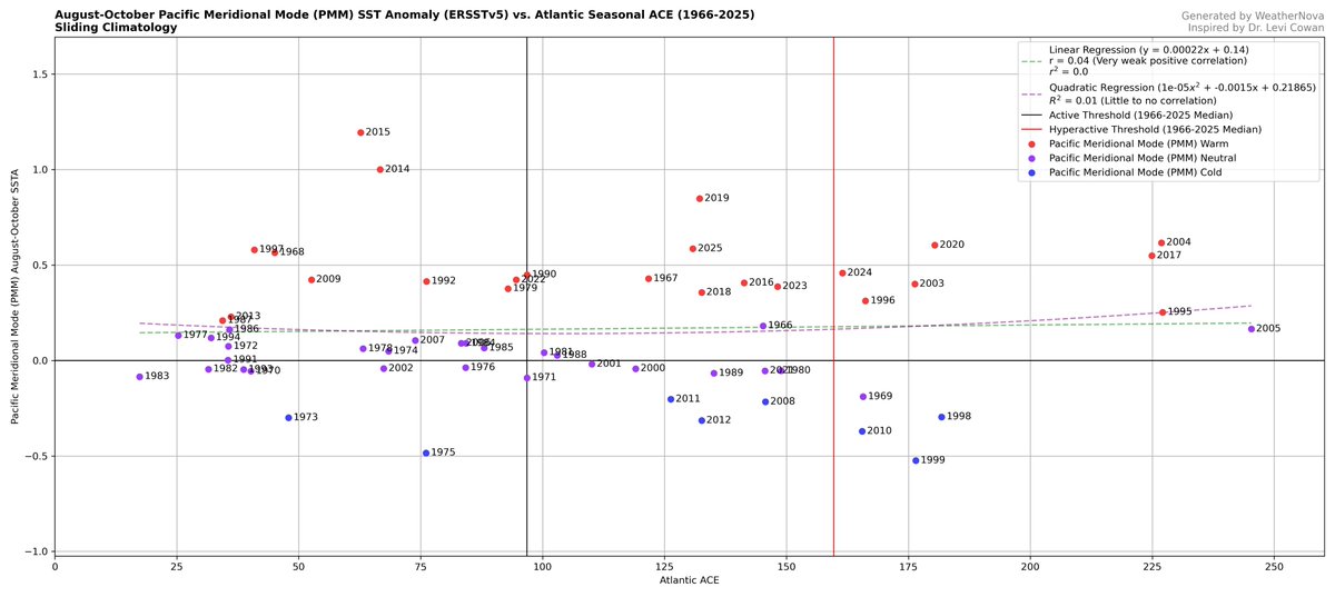
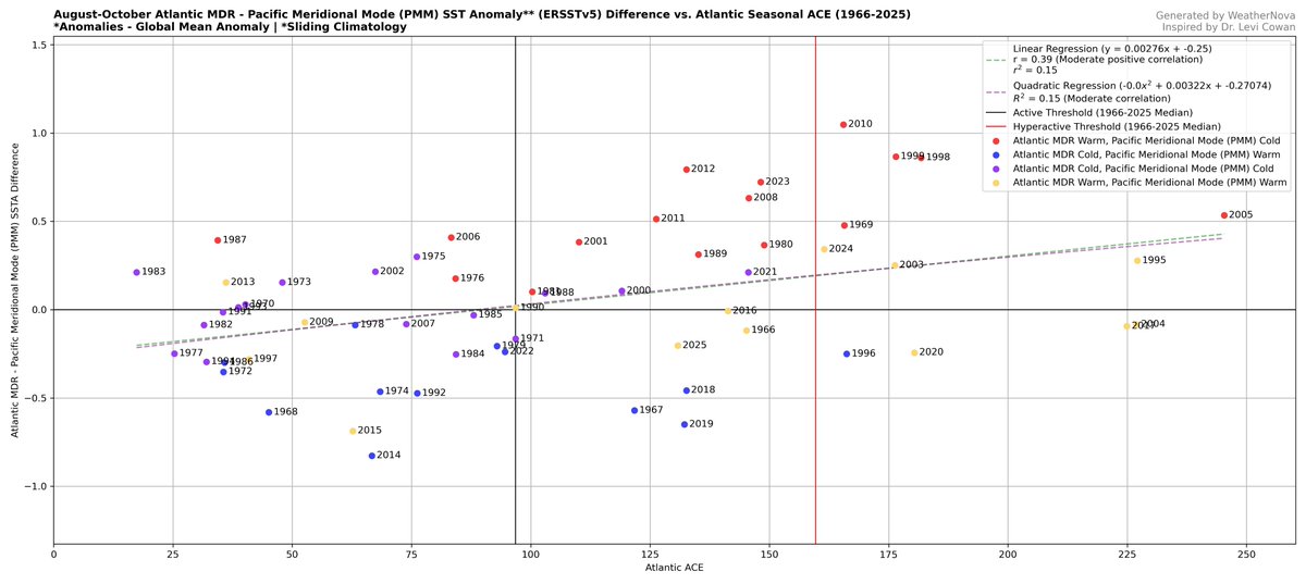
@rushtropicalwx@cyclonicwx I get similar results when only looking at the PMM ASO anomalies, though if you compare it directly to the Atlantic MDR, a better correlation appears.
@rushtropicalwx@cyclonicwx Yes when both areas are warm generally the result is a more wildcard season.
There could be some level of activity correlation depending on which one is warmer still, even if just slightly, though I think in those years, patterns like the PMM or AMM become much more important.
@rushtropicalwx@cyclonicwx I grabbed the average ASO global mean for each blue dot in the bottom-left quadrant of the MDR - Nino 3.4 graph. That turned out to be ~0.14°C.
That'd net a difference of -1.54°C (though probably lower with today's SSTAs).
This is similar to 1972, 1991, 1997, and 2015 in MJJ.
@phillywxguy_ One note about the CanSIPS on TropicalTidbits - It uses an outdated climatology.
When put against the modern 1991-2020 climatology the El Nino signature is vastly different.
@rushtropicalwx@cyclonicwx It's important to remember that even with the warming forecast by climate models, the fact that ENSO will most certainly be warmer than the Atlantic MDR doesn't give much confidence in higher seasonal activity.
The blue dots in the included charts show this relationship well.
🌀 The 2026 hurricane season officially begins on Monday. Here's my top-level discussion on what to expect throughout the season and over the next couple weeks.
Some random thoughts on the new era:
As AI steadily creeps into our work in the fields of meteorology and programming, there is an inevitable uneasiness associated with "losing control" and "becoming obsolete" as human developers and scientists. It's a fear I've occasionally felt, anyway, and I know I'm not alone. I used quotes because, while these are valid feelings, I don't think they must be reality.
The process of performing work is evolving as agents do more of it, but the impetus for that work is unchanged. We are the driving force of inspiration and curiosity that births our work in the first place. Taking ownership is the way to preserve autonomy and hard skills, and we're entering an era where that must be a personal, conscious choice.
If you're a student, you must pursue knowledge and stay hungry, lest silicon crutches leave you with passing grades but no ability. Harness AI to enhance your learning process, but never yield your understanding to it. Only you can ensure that.
If you're a programmer, AI is a dramatic accelerant - use it! It is the future of software. But insist on retaining ownership of your projects. Be a nosy manager, a steering influence on design decisions, and an intentional critic. The dopamine hit of pressing <Enter> will eventually wrest authorship from you otherwise.
If you're a scientist, AI is either expert-level in your field or will be someday. But science is still advanced by PIs, not AIs. Curiosity about the universe is a defining human trait - keep your curious hands on the rudder. Find the cutting edge and ride it; chances are you will advance the boundary with AI assistance far more than AI will alone.
Much about this new era is intimidating, but also exciting. I say grab it all by the horns and harness these capabilities for doing good in the world and your own life. Just choose continuously to protect your own sovereignty and humanity. Life is ours to live.
#NotWrittenByABot
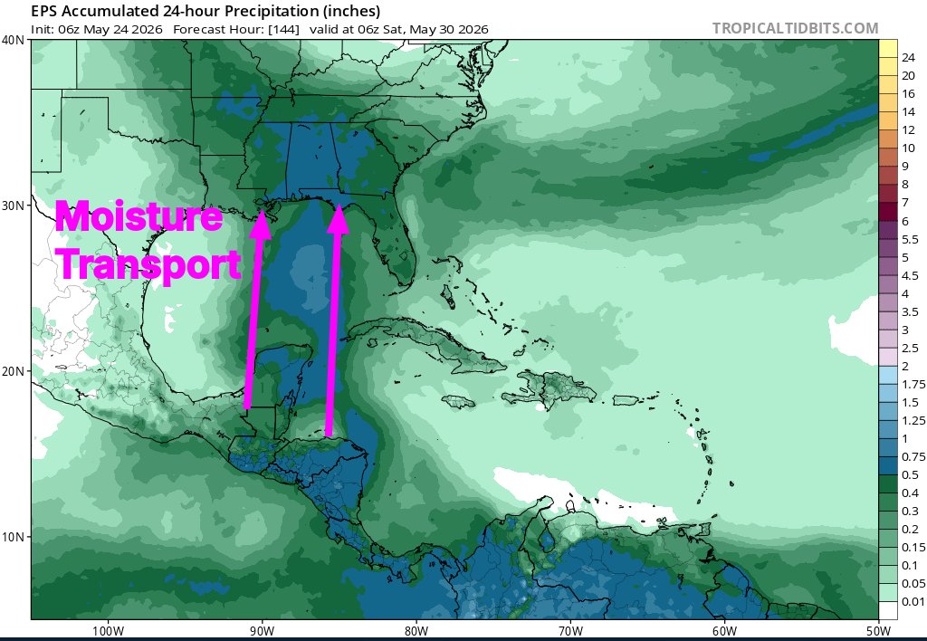
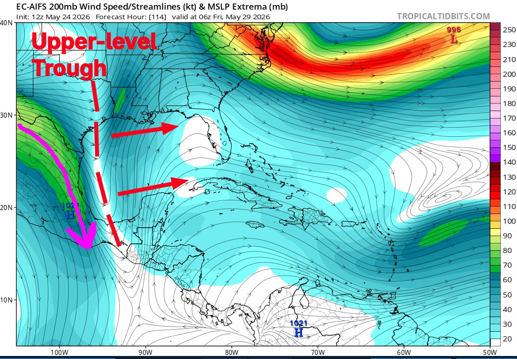
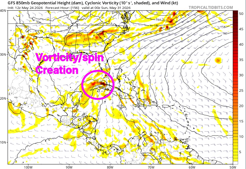
🌀Active weather may spread across the Gulf region later this week and weekend as an upper-level trough over Texas gets stretched out and amplified as it moves eastward over the Gulf.
🌀This trough will dig up tropical moisture and hoist it northward toward the southern states.
🌀The GFS model, perfectly in-character, is making its first noises of the hurricane season by developing weak cyclones along the moisture transport corridor. This model has a long-documented vorticity generation bias in such situations, which is likely deforming its forecast.
🌀Formation of a significant cyclone seems unlikely at this time, but models agree on heavy rains potentially spreading into the Gulf states from west to east beginning mid-week, potentially extending into next week.
I've finished my (unofficial) seasonal forecasts for the Atlantic, East/Central Pacific, and West Pacific, expecting the Atlantic to be below average and the Pacific as a whole to be above average this year.
Full reasoning-> https://t.co/UhVkEN838H
I've made an NMME version of the global mean anomaly charts going throughout hurricane season.
Noticeably warmer El Nino signal compared to the CanSIPS, with Nino 3.4 global mean anomalies exceeding +2°C by September and peaking near +2.5°C by November.
The plots I made before had an error in the climo period, but that issue has been fixed and the full May CanSIPS run (SSTAs and global mean) is included.
As hurricane season approaches, it's becoming certain a powerful El Niño phase is coming. New CanSIPS forecast for Aug rel. to 1991-2020 mean depicts textbook +ENSO config in the tropics. Even w/ global mean removed, Niño3.4 is about +2.0C! Big thanks @CosmicScout_ for the plots!
As hurricane season approaches, it's becoming certain a powerful El Niño phase is coming. New CanSIPS forecast for Aug rel. to 1991-2020 mean depicts textbook +ENSO config in the tropics. Even w/ global mean removed, Niño3.4 is about +2.0C! Big thanks @CosmicScout_ for the plots!
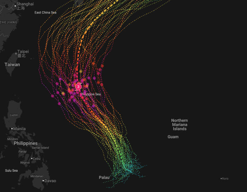
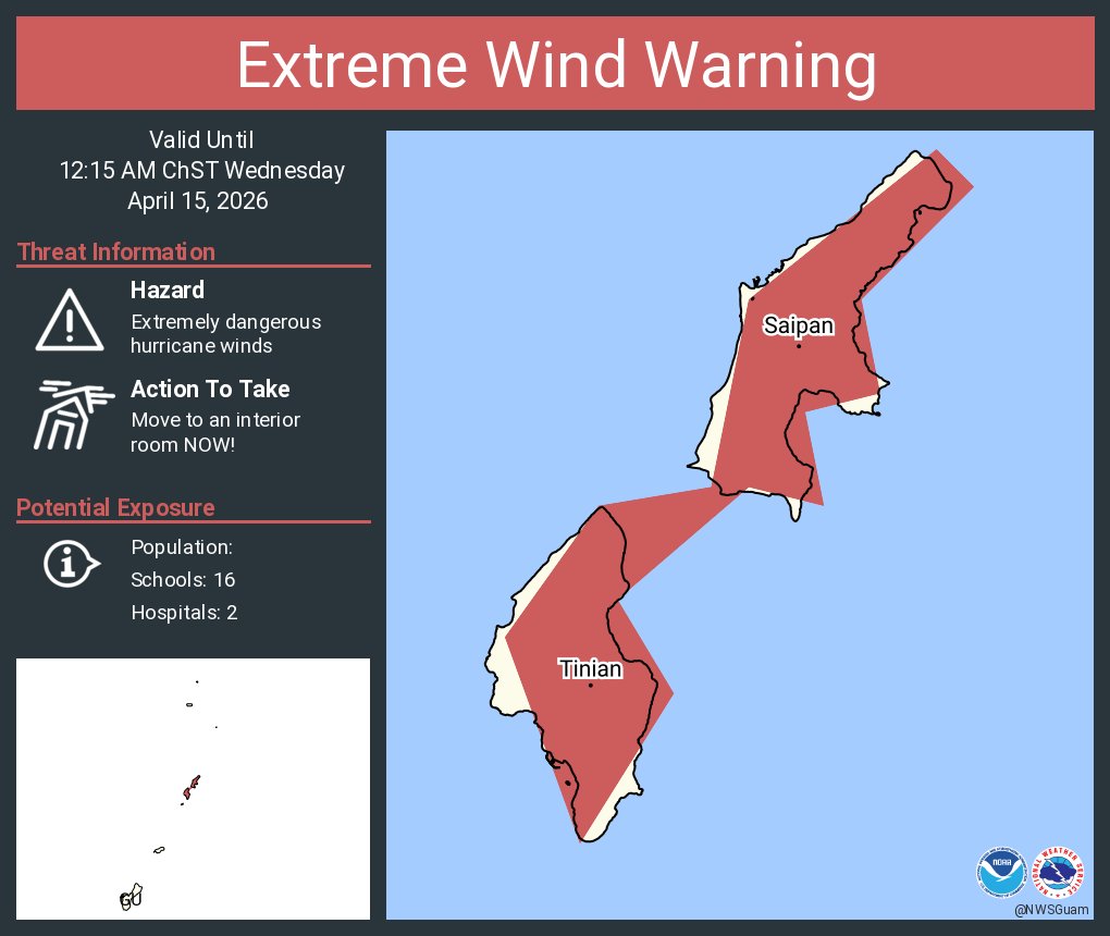
An extreme wind warning is in effect for Saipan MP, Tinian MP until 12:15 AM ChST for extremely dangerous hurricane winds. Treat these imminent extreme winds as if a tornado was approaching and move immediately to an interior room or shelter NOW!
Well it just gets better as the spacecraft approaches. All active global tropical/subtropical cyclones (TS 04W, TC 30P, and SS 31P) are in view. Breathtaking approach shot.