@7ftchkn@Raindropsmedia1 If handles were useful, all nozzles would have them. Nozzle person really only aims. She is correct with nozzle at the end of her reach. It increases range of motion. 1-3/4 is no joke at full pressure or volume. Really got some capts to consider letting the younger ffs handle it
@UnitedAgAndTurf What do y’all have for rice farming lol? My neighbors’ water line keeps leaking and has my yard flooded. They won’t fix it, the city won’t fix it. I decided to use the free irrigation to grow long grain rice. My JD 790 found the soft spot first lol so it’s too heavy.
I’m starting a rice empire! I gave them 2 years of flooding my yard. The weeds won’t be an eyesore with a crop in place and I’ll profit from their loss.
Oklahomaies and western Arkansas gang – SATURDAY, APRIL 25 looks like a classic BIG HAIL day. We'll have scattered hail-producing rotating supercells form east of I-35 around 3 p.m., and impact much of eastern Oklahoma and far western Arkansas.
It's a good day to park your vehicle beneath a carport or garage or in a sheltered location.
The meanest supercells could produce 3-4 inch diameter hail. That's bigger than baseballs and, in some cases, approaching softball size.
We have wind dynamics supportive of rotating storms, and maybe a couple tornadoes. Admittedly the low-level winds are a bit weak, which negates a greater tornado threat. The greatest spin is at the mid-levels, which is PERFECT for big hail.
Moreover, we have dry air at the mid levels. That means less moisture falls out of the cloud as rain, and instead we have more tiny supercooled water droplets to stick onto growing hailstones and make them even bigger.
Temperatures get chilly FAST with height too. We call those "steep lapse rates." As hailstones are lofted by thunderstorm updrafts, they encounter incredibly cold air.
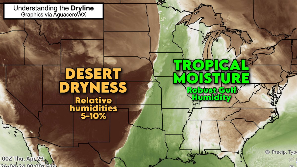
THE DRYLINE – no place in the world has a dryline as robust, sharp and impactful as we have in North America.
It's an extreme clash that exists on an order of miles. Tropical, Florida-like moisture juxtaposed against desert dryness.
In Oklahoma, a simple drive of 5 miles separates a Sahara-like airmass from rainforest-like moisture. Unless you've experienced it, it's hard to believe. Dew points will vary by 50 degrees in barely 8 miles!
The dryline is responsible for some of our nation's most dramatic weather. The clashing air masses routinely brew severe thunderstorms with tornadoes, baseball-sized hail and torrential rains. Like clockwork, rounds of violent storms crop up every April and May.
Unlike cold fronts, drylines don't bring dropping temperatures. It often stays warm or even gets HOTTER behind storms.
So how does the dryline work? Thunderstorms happen because the dry air is denser than moist air. Yes, really! Air is mostly nitrogen gas (N2), which weighs more per molecule than water vapor (water gas). So the more water in the air, the lighter the air is compared to dry air, which is mostly N2.
That's why the dry, dense air effectively impinges upon, and kicks up, pockets of moisture-laden air to the east. That often generates storms.