We will be holding onto the heat, but a little less of the haze over the next few days. Here is an update from the Valley Storm Team Weather Center as we race towards the 4th of July weekend.
We should see less of the haze today which made our skies a bit scuzzy yesterday. It will be sunny and hot today with highs ranging from 100 out west to the upper 80's at the coast. Most of us will top out in the mid to upper 90's. Heat index will be in the 105-110 range.
We will be keeping it hot and a little breezy this afternoon. Most of the RGV will reach the mid to upper 90's for highs with 101 likely in some areas of Starr County. SPI should reach 87. The heat index will have it feeling like 100-110 during the hottest part of the day.
We are looking at another typical late June day for the RGV. We will enjoy plenty of sunshine and highs in the mid to upper 90's for most inland areas and the upper 80's at SPI. Humidity will make it feel like 100-105. Winds will be gusting to 30mph.
We will enjoy plenty of sunshine today with highs ranging from 98 in Rio Grande City to 93 in Brownsville, and 87 at SPI. Our usual June humidity will make it feel like 100-108 during the hottest part of the afternoon.
The rains over the last month or so are having a slight impact on our lake levels. For the first time in quite a while, both our main water reservoirs have gone up in the last 30 days. They are still below where we need them to be, but it is nice to see some improvement.
It is going to be a toasty Tuesday with mostly sunny skies. Highs will be in the mid to upper 90's for most of the Valley. The humidity will make it feel more like 105-110 in some areas.
Today will be a typical late June kind of day. It will be hot and breezy with mostly sunny skies. Highs will range from 99 in Rio Grande City, to 94 in Brownsville, and 89 at SPI. The heat index will make it feel like 108-111 this afternoon.
We won't be quite as hot as yesterday, but it will still be dangerously hot this afternoon due to the combination of heat & humidity making some areas feel like 115-121. Extreme heat warning: noon-7pm today. Small chances for a shower or thunderstorm overnight.
Caution is advised for any outdoor activities this afternoon as we are expecting dangerous heat. Here is the latest from the Valley Storm Team Weather Center.
The Valley will have dangerous heat conditions this afternoon as our highs reach into the triple digits. Factor in the humidity, & it will feel like 120+ in many areas during the hottest part of the day. We do have an excessive heat warning from 1-8pm today. Exercise caution!
We officially have our first tropical storm of the 2026 hurricane season. It will be a weak tropical storm for only a short time as it moves inland later today. Say hello to Arthur. The main threat will be life-threatening flooding as it moves quickly northeastward.
We are swapping out the flooding concerns with dangerous heat conditions for today and tomorrow. Forecaster Craig Verley has the latest from the Valley Storm Team Weather Center.
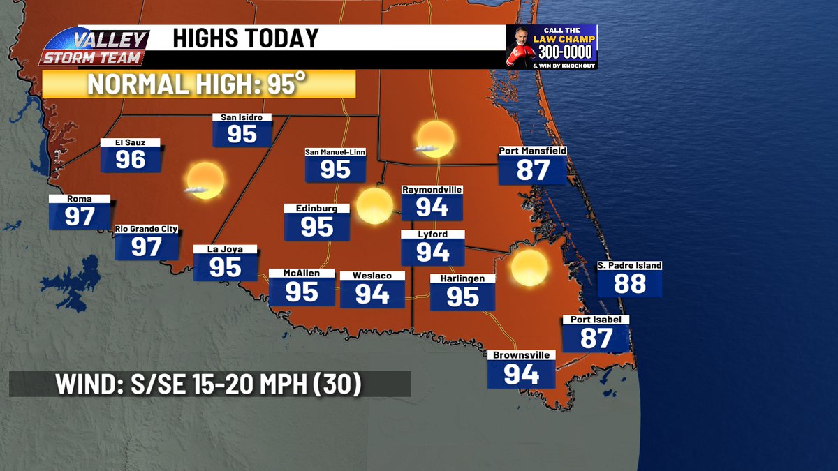
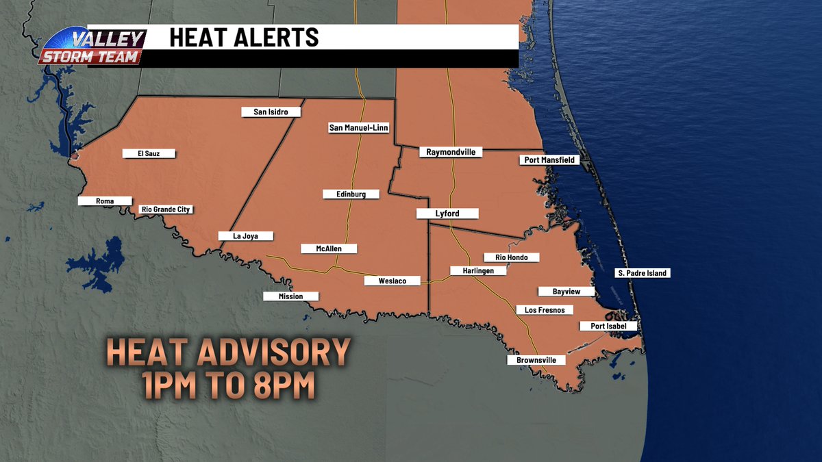
We are replacing rain alerts with heat alerts today. We will be mostly sunny, hot, and humid. Highs will be in the mid to upper 90's. But w/ the humidity it will feel like 110-114, resulting in a heat advisory from 1-8pm today. Be careful during outdoor activities today!
The National Weather Service has issued two flood advisories (green boxes) in Willacy and Cameron Counties due to heavy rains passing through that may drop an additional 1-2 inches, leading to minor flooding in those areas. A flash flood watch continues until 7am Wed.
The flash flood watch continues for the RGV until 7am Wednesday. We can expect more scattered showers and thunderstorms, some of which could include heavy rain. So flash flooding will continue to be a concern. Highs will be in the mid to lower 80's.