🌌 Tonight: Clearing out and staying mild.
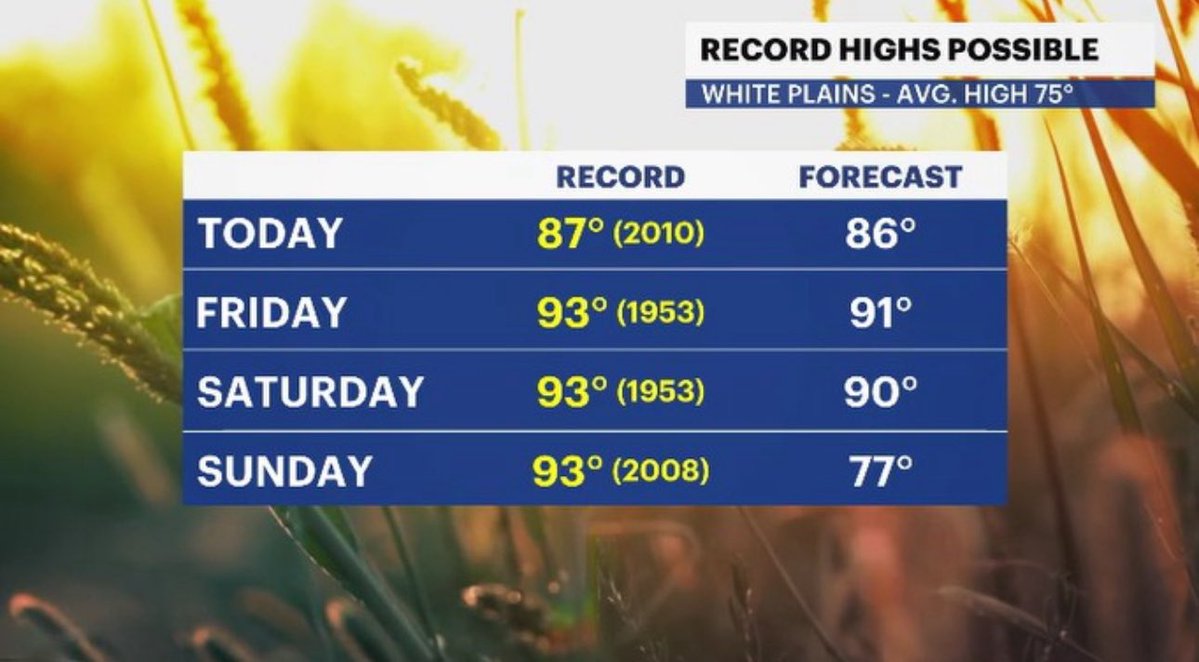
🔥 Friday: Hot & toasty. ⚠️Air Quality Alert is active from 11 AM to 11 PM, so take it easy outside!
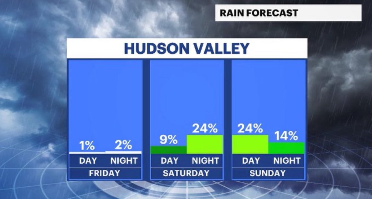
🌧️ Saturday: Another hot one, but watch out for late-day showers/storms. #HVwx#WCwx
Grab the sunglasses 😎 and the sunscreen 🧴 today in the #HudsonValley!
🌤️ we got p. sunny skies & warm temps
🤧 along with UV index, pollen also high
🥇 ❓ potential record high temps in sight
🌧️ rain is in sight for the weekend
https://t.co/0V5Ft6Vecf
#nywx#news12
The countdown to the official start of summer is under 3 weeks, but a preview arrives early! 📈 Friday and Saturday will push the limits with challenging record highs, and a noticeably more humid weekend across the area. 🥵🌞#HVwx#WCwx
🙅🏾♂️ The debate is over. Today wins the award in the #HudsonValley!
🥇 today is #PickOfTheWeek! Enjoy!
🧴 🤧 UV index & pollen run high though
📈 🌡️ temps will approach records soon
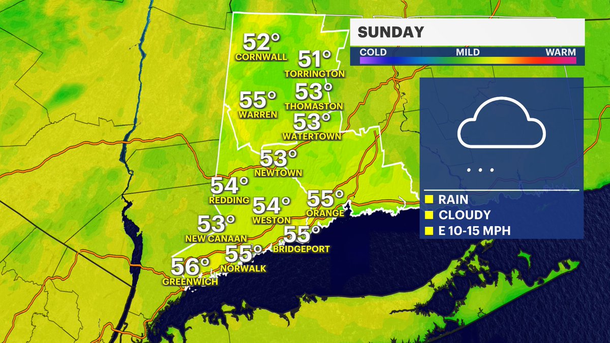
🌧️ it’s a 50/50 split weekend w/ Sunday turning crummy
https://t.co/0V5Ft6Vecf
#nywx#news12
👀 Would you look at that, #HudsonValley!
🌡️ temps rise nicely this week!
⛅️ it’s a p. cloudy & pleasant day today
🥇 *Pick of the week* status for WED!
☔️ rain-free this week, until the weekend
📉 temps cool down as rain falls Sunday
https://t.co/0V5Ft6Vecf
#nywx#news12
The outlook from @NWSCPC for June 6-12 favors above normal temps across much of the country with a slight risk of extreme heat into Ohio, far western Pennsylvania, northern Kentucky and the Ohio River Valley of West Virginia.
Happy Friday-Eve! A few quick showers through this afternoon, but most of the Hudson Valley is looking bright! 🌤️ The sun prevails, and we are on track for an absolutely beautiful weekend. 😎
Another nice one on tap for Thursday! Not as humid, breezier conditions and highs in the lower to mid 70s! There is a small risk of an isolated shower for some spots across the Lower Hudson Valley, but majority of us stay dry! 🌤️#WCwx
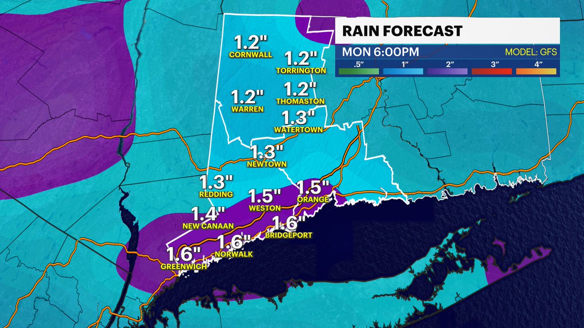
🇺🇸 MDW was a wet one, but several dry hours are on the way this afternoon to end the holiday. Not much sun, plenty of clouds, but at least it is not pouring rain. All we could squeeze out this year. Enjoy! #ctwx#News12
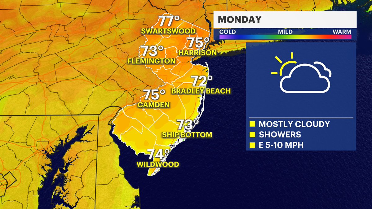
🌤️ Memorial Day Forecast Update! 🌤️ 🌧️ Rain finally moves out by the afternoon. 🌡️ Temps rebound nicely into the 70s. ☀️ Keep an eye out for some late-day sunshine! Have a safe and happy holiday! 🌭#NJwx
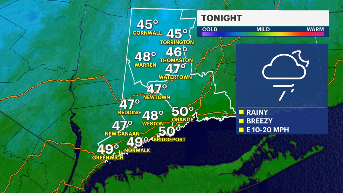
This isn't quite the holiday weekend weather we were hoping for! 🌧️ Showers and chilly temps stuck in the 50s will continue through Sunday. Good news is Monday brings a beautiful rebound with afternoon sun and highs back in the 70s just in time for Memorial Day! ☀️#News12#CTwx
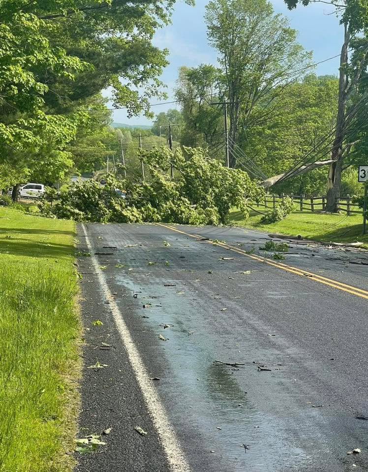
Lots of damage today in a localized swath from Westchester County into Ridgefield, Wilton, and Georgetown. This is fairly common on Level 2 Severe Risk days - as severe storms will occur somewhere in the area, but are not necessarily widespread. This creates a forecast challenge as you obviously want to mention the potential for severe storms, but don’t want to overblow the wording when it’s likely a good chunk of the area won’t see much at all.
It’s also impossible to know in advance if a certain spot will, or will not, get hit. Unlike winter storms which are regional in scale, a severe storm is often only a few miles wide. This makes the radar analysis crucial. Today I actually thought was a great forecast, as models sniffed out the greater threat south.
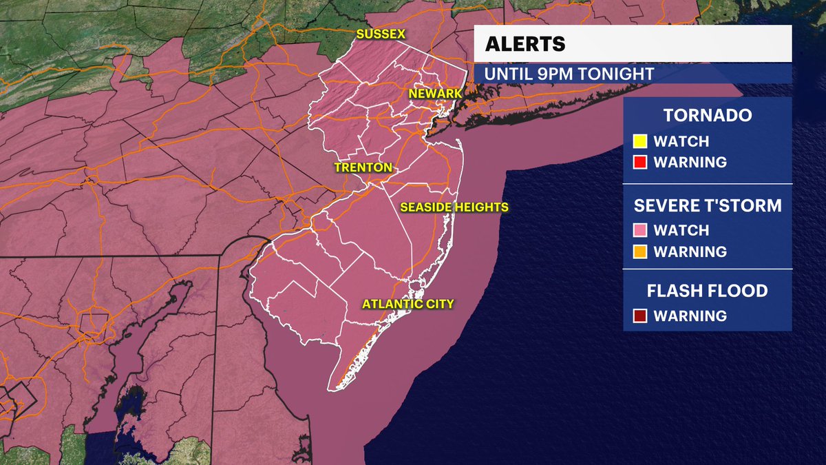
🚨Severe T-Storm Watch for NJ until 9pm.
⛈️Scattered severe storms heading our way from west to east late this afternoon into the evening.
The biggest thing to watch out for is damaging wind gusts up to 70 mph, but we could also see hail and heavy downpours☔️ #NJwx
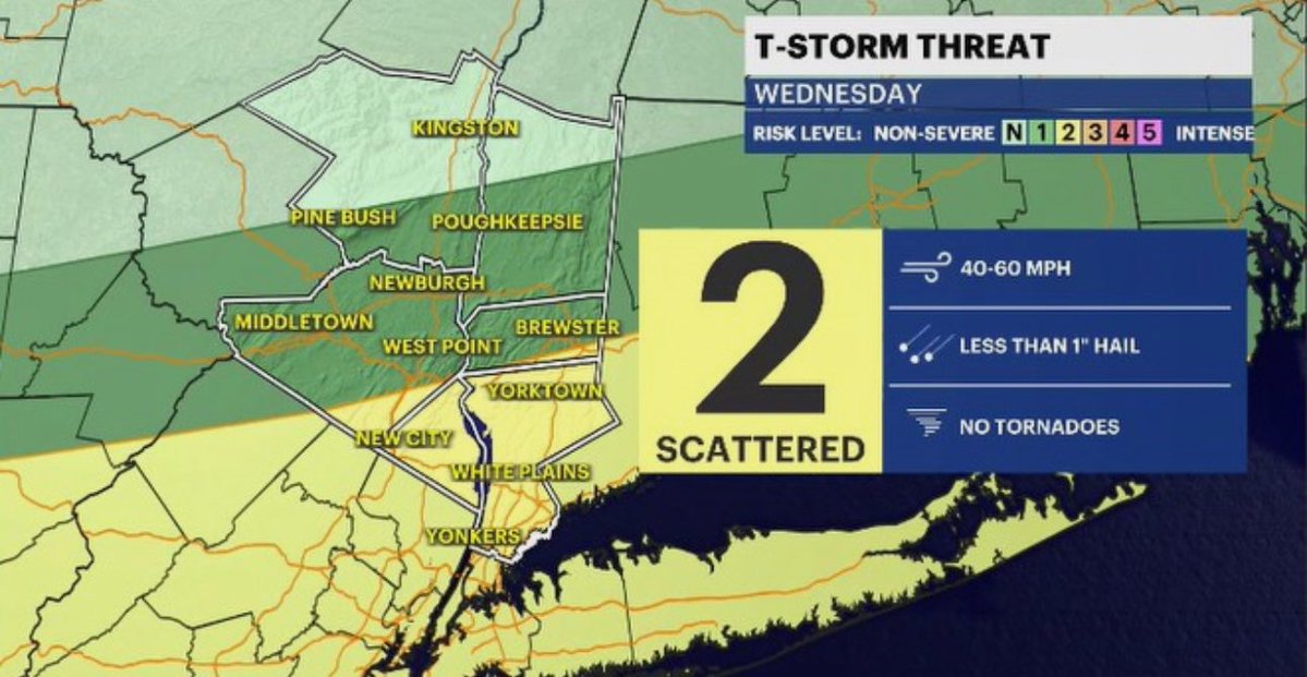
🚨 severe potential has increased for the #HudsonValley
🌬️ damaging gusts are a main concern for much of the region
🧊 small hail is a possibility
🌧️ quick downpours are likely
⏰ time: is 3-11 PM
@JSeawright_TVWX will have updates today
https://t.co/0V5Ft6Vecf
#nywx#news12
👀 🥵 ⛈️ big changes are on the way, #HudsonValley!
🌡️ 📈 temps climb to Summer levels again today!
⚡️ severe storms possible later today
🌡️ 📉 temps drop THU
🌧️ 🌬️ it’s a dreary day on SAT
🇺🇸 #MemorialDay Weekend sees slow improvements
https://t.co/0V5Ft6Vecf
#nywx#news12
🥵 🌶️ #HudsonValley is going to be toasty today!
🌡️ 📈 temps climb towards record levels
😥 humidity will also rise
😷 air quality a concern again
⛈️ iso. PM storm chance later
🌡️ 📉 temps cool down by THU
https://t.co/0V5Ft6Vecf
#nywx#news12