HI Steve here interested in Football, Baseball , NASCAR.. Weather Enthusiast, Delmarva Skywarn, Amateur Radio, Emergency Communications #BACKTHEBLUE#ukraine
DEMA, DSP, and PSEG will test the Salem/Hope Creek Nuclear Station alert system on Tuesday, July 7, 2026 at 7:20 p.m. Sirens will be activated for 3-5 minutes, followed by a test message of the Emergency Alert System on local radio.
Read more: https://t.co/Mqof0XZoJy
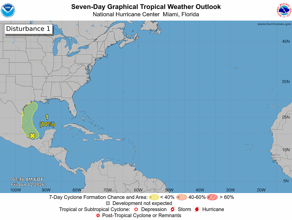
8 am EDT Fri, Jun 12: A broad area of low pressure over the southern Bay of Campeche is producing disorganized showers and thunderstorms. Any development before the system moves inland over eastern Mexico this weekend is expected to be limited. The system could re-emerge over the northwestern Gulf next week, but formation chances remain low (10%) through 7 days.
Monitor https://t.co/Wq6ZtKfHp9 for the latest forecast.
Temperatures continue to be on the rise today along with high humidity.
Changing some small habits will go a long way. Stay hydrated, wear loose-fitting, lightweight clothing, and apply sunscreen at least 20-30 minutes before any sun exposure.
⛈️ A few severe storms are possible again later this afternoon and evening. Coverage of storms is anticipated to be lower than Thursday, and not everyone will see storms. Damaging wind gusts are the main threat today. Remain alert for changing conditions! #PAwx#NJwx#DEwx#MDwx
⛈️ Scattered showers and storms are forecast to develop this afternoon and evening. A few storms could be strong to severe, with locally damaging winds and brief heavy downpours possible. #PAwx#NJwx#DEwx#MDwx
Humidity will increase substantially today despite highs mid 80s. A few morning showers possible, then scattered storms are forecast to develop this afternoon (4-10 PM). A few storms could be severe, with locally damaging winds and brief downpours. #PAwx#NJwx#DEwx#MDwx
Another warm and tranquil night is in store for the area with lows in the 60s, light southwesterly winds, and mostly clear skies. Scattered storms, including some severe, will be possible across portions of the area Saturday afternoon and evening!
#PAwx#NJwx#DEwx#MDwx
⛅️ Pleasant, dry, & seasonable conditions will persist through the middle of the week. Temps tonight & Tues morning will be on the cooler side, with lows roughly 10° below normal. Patchy fog/dew possible. Warming up late week, with highs near 90° by Fri. #PAwx#NJwx#DEwx#MDwx
Special Marine Warning including the Coastal waters from Great Egg Inlet to Cape May NJ out 20 NM, Delaware Bay waters north of East Point NJ to Slaughter Beach DE and Delaware Bay waters south of East Point NJ to Slaughter Beach DE until 1:00 PM EDT
Good morning! No significant changes to the severe weather outlook for later today with the threat focused over Delmarva.
For this morning, expect some showers moving through with maybe a few rumbles of thunder. The severe threat is more for the afternoon though.
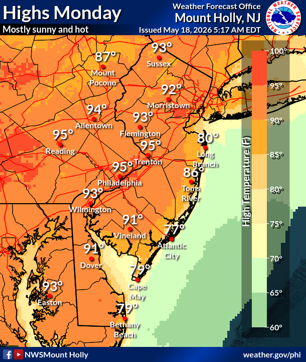
🥵🌤️ The first of 3 hot days begins today, with temperatures reaching into the low to mid 90s in many areas this afternoon. Record highs will be challenged through Wednesday, and even some monthly records for May challenged on Tuesday. Stay cool out there! #PAwx#NJwx#DEwx#MDwx
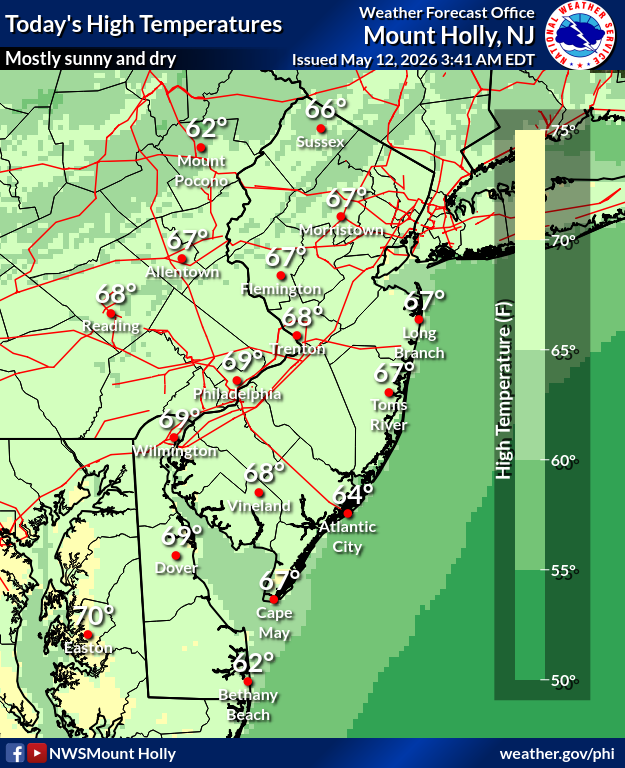
Good Tuesday morning! While high temperatures today will still be below average, it will be milder than yesterday. There will be plenty of sunshine as well. Have a great day! #pawx#njwx#dewx#mdwx
Temperatures will be near normal today with clear skies early and increasing clouds late. There is a low chance for a few showers across the Poconos and far northern NJ this afternoon. It will also be breezy, with west winds gusting as high as 30 mph.
#PAwx#NJwx#MDwx#DEwx
Do you know what to do when a storm threatens? Prepare for hurricane season by taking the time now to understand the actions needed when time is of the essence. #HurricanePrep#HurricaneStrong
https://t.co/l0jVM69oPh