BREAKING 🚨
🚨 FLASH FLOODS HIT FORT WORTH & TARRANT COUNTY 🌊⚠️ — Roads are turning into rivers as heavy rain causes dangerous flooding across the area. Avoid flooded roadways & NEVER drive through standing water! #FortWorth#TarrantCounty#FlashFlood#DFW
BREAKING ‼️ GRAPHIC CONTENT ⚠️
STUDENT DIES AFTER FALLING FROM BUILDING AT HIGH SCHOOL IN HIGHLAND PARK. A student has died after falling from a building at a high school in Highland Park Wednesday afternoon, prompting a lockdown on campus.
BREAKING 🚨 FLOODING ALERT: VEHICLES FLOODED OUT NEAR HULEN ST & I-30
Several vehicles have reportedly become flooded out near Hulen Street and I-30, in the area of Arlington Heights High School.
Drivers should use extreme caution and avoid flooded roadways when possible. Water depth can be difficult to judge, and conditions may change quickly.
⚠️ Turn around, don’t drown. Never drive through standing or moving water if you’re unsure of the depth.
📍 Hulen St & I-30 | Fort Worth
🚨 TRAFFIC ALERT — MAJOR DELAYS 🚨
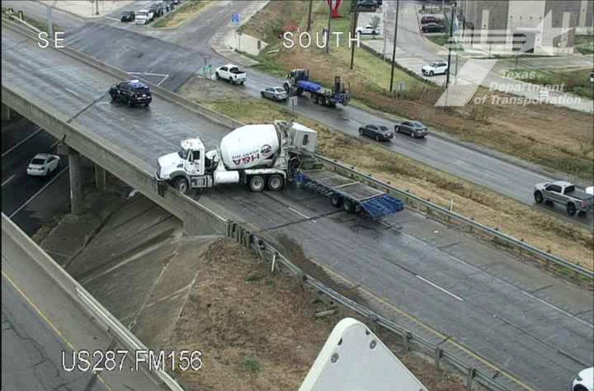
Wet roads are creating hazardous driving conditions, and another crash is now blocking the southbound lanes of US 287 near Blue Mound in North Fort Worth.
🚗 Expect significant delays and heavy congestion approaching the area, with backups extending toward Wise County. Drivers are urged to slow down, use caution, and consider an alternate route if possible. #dwxx #trafficalert
🌧️ NORTH TEXAS WEATHER ALERT: FLOODING CONCERNS INCREASE AS HEAVY RAIN APPROACHES
The National Weather Service has issued a Flood Watch for portions of North and Central Texas beginning Wednesday, September 30, at 4 PM and continuing through Thursday, October 1, at 1 PM.
Forecasters are monitoring a slow-moving storm system expected to bring widespread rainfall across the region.
Some areas could receive several inches of rain, with isolated locations potentially seeing totals approaching 8 inches.
The watch area could be expanded farther east depending on the storm system’s movement and updated forecast conditions.
Residents are encouraged to monitor official National Weather Service updates as the forecast develops.
Bottom line: North Texas could be in for a very wet couple of days. Stay weather-aware!
🌧️ Stay tuned for updates.
Forecast details: National Weather Service and current regional reporting. <Cite refs={[“turn508226search10”,“turn508226news0”]}/>
🚨 PEDESTRIAN SERIOUSLY INJURED IN HALTOM CITY HIT-AND-RUN
Haltom City Police responded to a reported major traffic collision involving a pedestrian in the 4100 block of East Belknap Street Saturday night at approximately 8:00 p.m.
According to preliminary information, the pedestrian was struck by a white Dodge pickup truck that left the scene. The pedestrian was then struck by a second vehicle.
The pedestrian was transported to a local hospital for treatment of serious injuries.
Officers are continuing to investigate the incident and are working to identify the driver of the vehicle that reportedly left the scene.
📍 Location: 4100 block of East Belknap Street, Haltom City
🕗 Time: Approximately 8:00 p.m., Saturday
Anyone who may have witnessed the crash or has information that could assist investigators is encouraged to contact the Haltom City Police Department.
⚠️ This is an ongoing investigation. Details may change as additional information becomes available.


![DFWNEWS911's tweet photo. 🌧️ NORTH TEXAS WEATHER ALERT: FLOODING CONCERNS INCREASE AS HEAVY RAIN APPROACHES
The National Weather Service has issued a Flood Watch for portions of North and Central Texas beginning Wednesday, September 30, at 4 PM and continuing through Thursday, October 1, at 1 PM.
Forecasters are monitoring a slow-moving storm system expected to bring widespread rainfall across the region.
Some areas could receive several inches of rain, with isolated locations potentially seeing totals approaching 8 inches.
The watch area could be expanded farther east depending on the storm system’s movement and updated forecast conditions.
Residents are encouraged to monitor official National Weather Service updates as the forecast develops.
Bottom line: North Texas could be in for a very wet couple of days. Stay weather-aware!
🌧️ Stay tuned for updates.
Forecast details: National Weather Service and current regional reporting. <Cite refs={[“turn508226search10”,“turn508226news0”]}/>](https://pbs.twimg.com/media/HTeeuvbX0AApgW1.jpg)


