The Dripping Springs, TX Emergency Management Commission provides info about area emergencies, extreme weather events and proactive safety and health data.
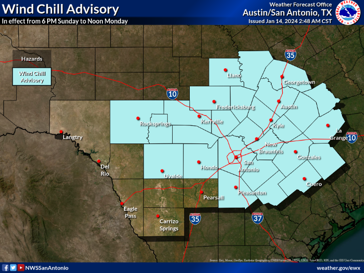
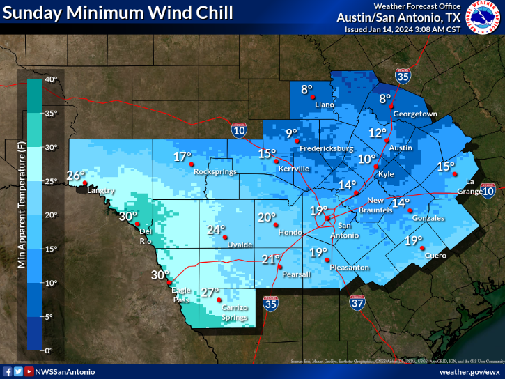
Wind Chill Advisory now in effect from 6 pm Sun to Noon Mon. Additional Advisories likely, and Warnings possible through Wednesday morning. Dangerous wind chills, in the single digits above zero, at times, through Wednesday morning. Plan accordingly.
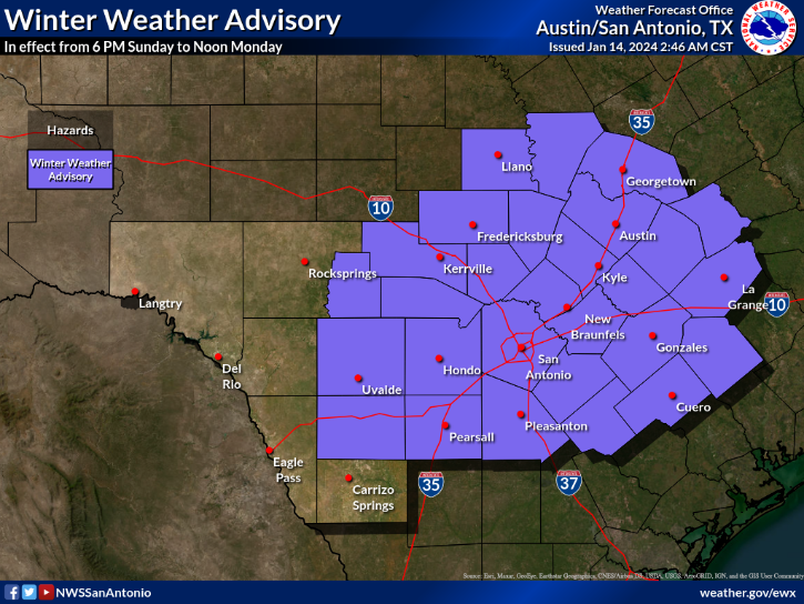
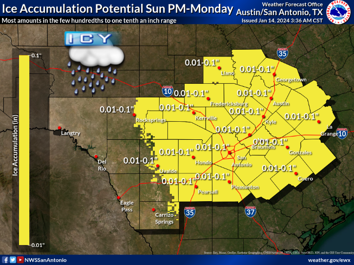
Winter Weather Advisory now in effect from 6 pm Sun to Noon Mon. Ice Accumulations from 0.01-0.10" possible, mainly on bridges, overpasses, and elevated surfaces. Plan accordingly.
On the Hays County COVID-19 Vaccine Pre-registration List? We send appt. info via email, phone & text. Look in spam/junk folders and voicemail boxes! You'll get appt. info, including changes to your location and/or time, via at least one of these methods. https://t.co/HwgzKLrAF9!
As severe winter weather impacts our state, Texans should:
- Stay off the roads
- Conserve energy
- Keep generators & grills outside
- Avoid heating homes with ovens or stovetops
For a full update on TX’s response to these dangerous conditions: https://t.co/EXVfm3tO6L @TDEM
7:42 PM CST Freezing drizzle/rain affecting the San Antonio metro area and vicinity. The activity is moving to the north and heading toward the Hill Country including Travis and Williamson Counties. Ice accumulations up to 0.1 of an inch possible. #txwx
Important Way to Stay Informed:
To receive COVID-19 updates via text — including news about a Shelter-in-Place order coming from Hays County later today — text AlertHays to 888-777
Remember, "Be Prepared, Not Panicked." - @ChiefKidd - https://t.co/asWWkJ7bgn For the latest #Coronavirus information from @TexasDSHS visit: https://t.co/Vo9Y1FRxfk
Today @ChiefKidd, along with state health officials and state agency reps, briefed Gov. @GregAbbott_TX, Lt. Gov. @DanPatrick, and Speaker @RepDennisBonnen, on the precautionary measures the state is taking to ensure the health and safety of all Texans in response to #coronavirus.
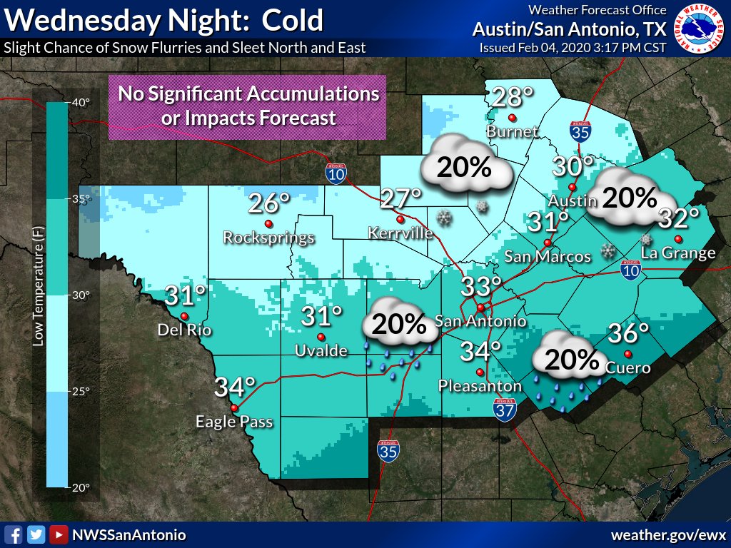
Models continue to trend drier for Wednesday night into early Thursday morning. We are currently only forecasting a 20% chance of a change over to light sleet or snow flurries across northern and eastern areas. Little to no accumulations or impacts are forecast at this time.
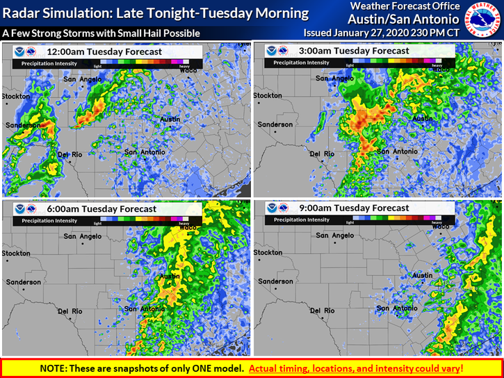
Showers and storms will traverse the region from west to east overnight and exit Tuesday morning. Isolated small hail is possible. Out west, skies are expected to clear out for Tuesday afternoon and breezy NW winds will develop.
Annual registration for the State of #Texas Emergency Assistance Registry (STEAR) has begun. If you have already registered in 2020, you do not need to re-register. For more information on #STEAR and how to register visit: https://t.co/VgWJ15N616
HaysCo Emergency Mgmt is encouraging residents to pay close attention to the weather tonight. As much as 3" of rain could occur in some areas. Countywide emergency information is posted at https://t.co/VPeugcPeih.
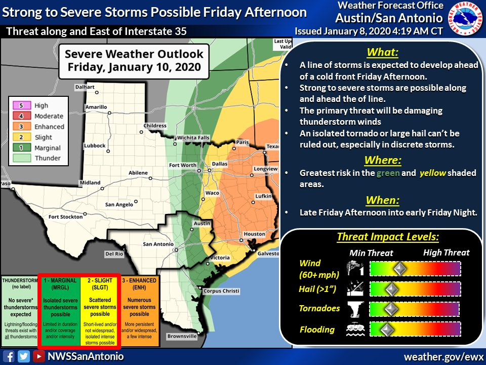
A few strong to severe storms will be possible along and east of the Interstate 35 corridor on Friday (1/10/20) afternoon and evening. @NWSSPC has placed our area in a Marginal and Slight risk of severe storms. The main hazard will be damaging thunderstorm winds. #txwx
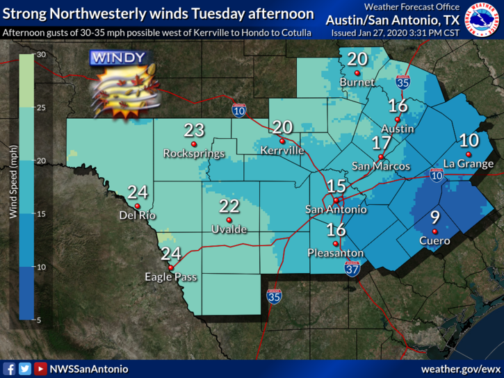
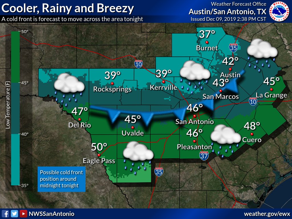
Weather changes on the way. A cold front is forecast to push across the area tonight with elevated chances for rain, but rainfall amounts will be limited to 1/4 inch or less. Northerly winds of 15 to 20 mph with gusts up to 30 mph along and behind the frontal passage. #txwx
10PM: Freezing Rain and sleet reported through the Hill Country and Austin metro area. Light glazing of ice is occurring on exposed metal objects and elevated surfaces. Most main roads are currently ok, however some bridges and overpasses may be susceptible to icing overnight,
⚠️⛈️ Scattered to numerous showers and storms are forecast to develop Thu afternoon across portions of the Hill Country and Rio Grande. These storms are forecast to develop into a line Thursday evening along and east of the I-35 corridor. This is just one model snapshot.
Pockets of locally heavy rainfall across the Hill Country and along and east of the I-35 corridor could lead to flooding in some isolated areas late Thursday afternoon and night.
Did you turn on your heater for the first time in a while and get a funny smell? Should you worry? The Hays County Fire Marshal answers questions about heater smells.
https://t.co/Cjcp3IMyEJ