Afternoon Tropical Run — Aug. 27, 2026
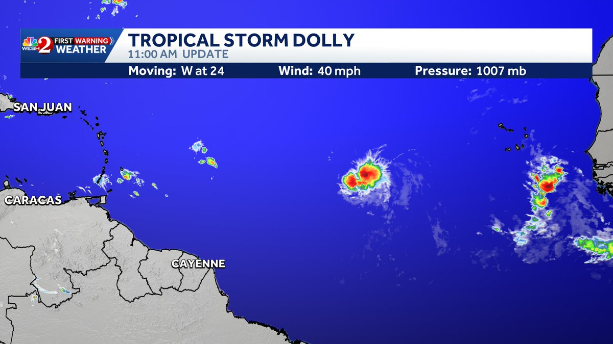
The afternoon guidance continues to focus overwhelmingly on Tropical Storm Dolly, now in the central tropical Atlantic near roughly 14°N, 39°W. Satellite imagery shows a compact but well-defined convective system with very cold cloud tops near the center.
What the models are showing:
🌀 Dolly is the only system highlighted by the NHC on the current seven-day outlook.
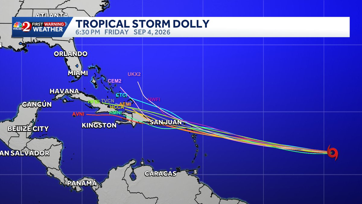
➡️ The ensemble guidance strongly agrees on a west to west-northwest track during the next several days, taking Dolly toward the northeastern Caribbean/Leeward Islands region.
📍 The track clustering approaching the islands is fairly tight, giving relatively good confidence in the general westward motion. Exact latitude becomes much more important later.
🔀 After roughly 5–7 days, uncertainty increases sharply. Some ensemble members turn the system north near or east of the Bahamas, while others continue farther west toward the Bahamas/Florida vicinity.
🌊 Atlantic sea-surface temperatures are generally warmer than average, including much of the western Atlantic. Ocean temperatures therefore don't appear to be the primary limiting factor.
💨 The track colors indicate that at least some ensemble members strengthen Dolly substantially, including members reaching hurricane intensity. These are possibilities within the ensemble, not a deterministic intensity forecast.
🇺🇸 There is no reliable Florida landfall signal at this point. Some long-range members eventually approach Florida or the Southeast, but others recurve well offshore. At 10–15 days, individual tracks should not be treated as forecasts.
For Vero Beach / Indian River County
There is nothing in this afternoon run that calls for concern in Florida right now. Dolly is still thousands of miles away, and whether it ever becomes relevant to Florida depends heavily on the position and strength of the subtropical ridge next week.
The first major checkpoint is how far north Dolly gets while approaching the northeastern Caribbean. A farther-north track would generally increase the opportunity for an earlier turn into the western Atlantic; a farther-south track could allow the system to travel considerably farther west before finding a weakness in the ridge.
Bottom line: 🟢 Florida threat too early to determine → 🟡 Dolly bears watching over the next week → 🌀 ensemble support for continued development exists → 📅 the early-to-middle part of next week should begin providing much more useful information about whether Florida needs to pay closer attention.
Tropical Storm #Dolly has formed and likely will be a short lived storm as upper level strong winds and dry air will take its toll on this system as early as tomorrow and on approach to the #Leeward Islands. Stay with #weshwx for updates.
TROPICS: Keeping an eye on Invest 96L. I'm not worried about it yet. Will tell you when to be. Otherwise, not a concern at this time. However, the trend has been for this to track weaker and further south, which is what would need to happen for it to survive through the hostile region of El Nino caused wind shear.
The area around FL, the Bahamas, and SW Atlantic is one of the only places in the entire Atlantic Ocean basin that is somewhat favorable for tropical development right now this year.
Our FOX Model has a weak tropical wave north of Puerto Rico next Monday. From there it could either die off entirely or survive long enough to get to a point where it could become something more meaningful. For now, we will sit and wait.
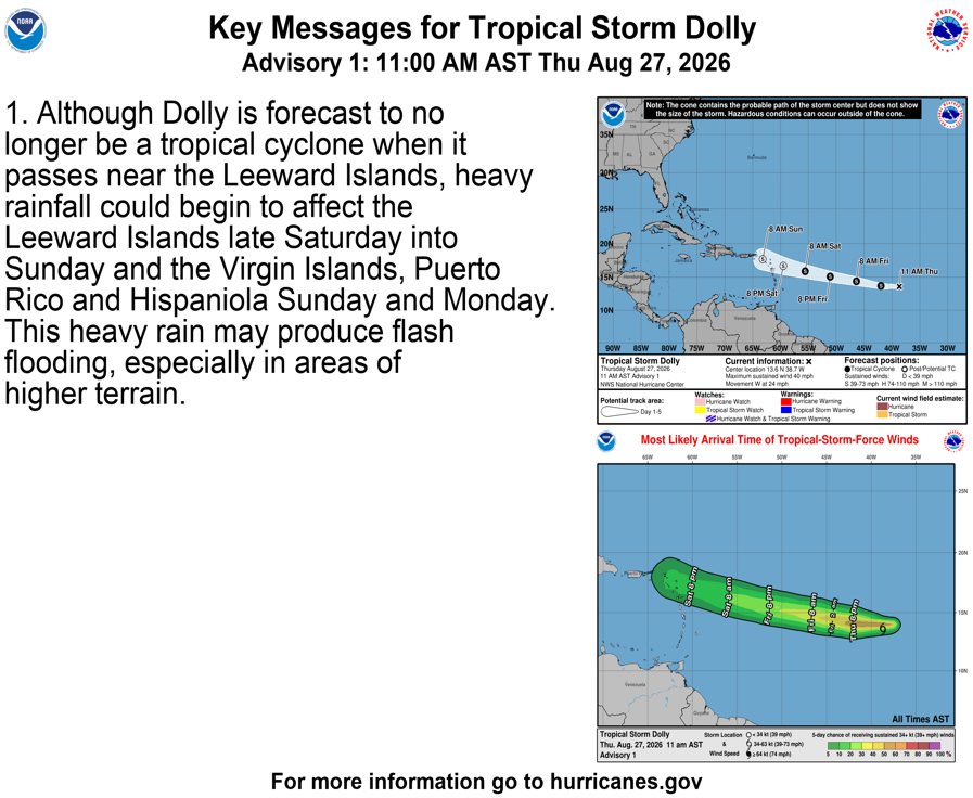
11 AM AST Thu Aug 27 (Advisory 1) Key Messages for Tropical Storm #Dolly. Latest info: https://t.co/GrztW6mQJV
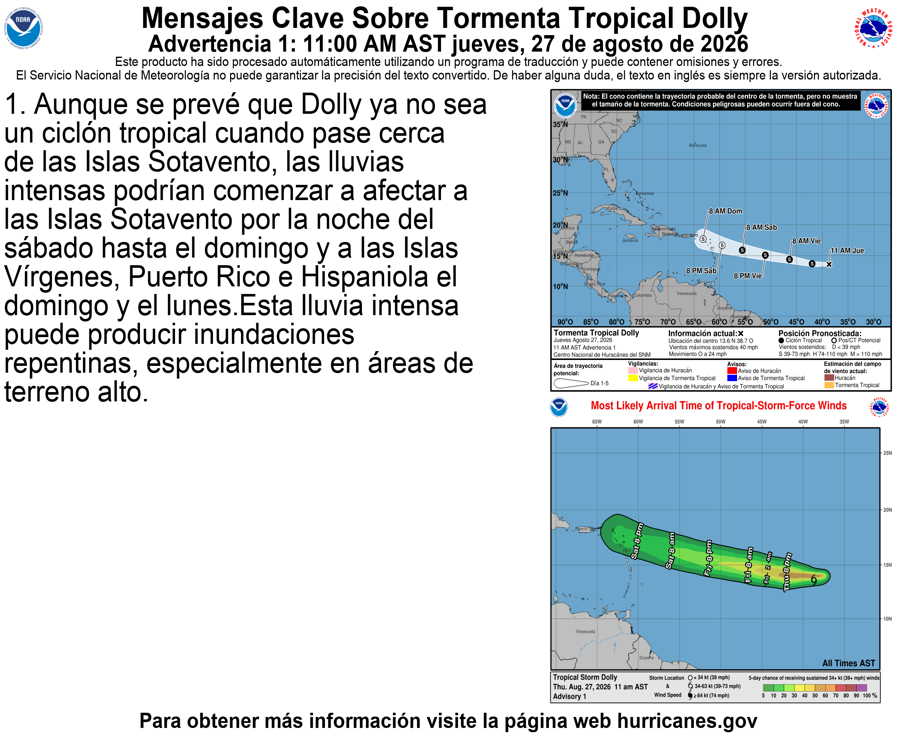
11 AM AST jueves 27 de agosto (Aviso 1) Mensajes clave sobre la tormenta tropical #Dolly. Más información: https://t.co/GrztW6mQJV
🌴 East Central Florida Weather Summary — August 27, 2026
Hot, humid and stormy afternoons remain the main story through the weekend and into early next week.
⛈️ Today: Scattered to numerous thunderstorms are expected, mainly 2–10 PM. Rain chances are around 50–70%, including about 60% around Melbourne and 50% around Vero Beach/Fort Pierce.
⚠️ Strong storm potential: A few storms could produce 45–55 mph wind gusts, frequent lightning and torrential rainfall. Isolated rainfall totals of 1–3 inches in only 30–60 minutes could cause ponding and localized flooding.
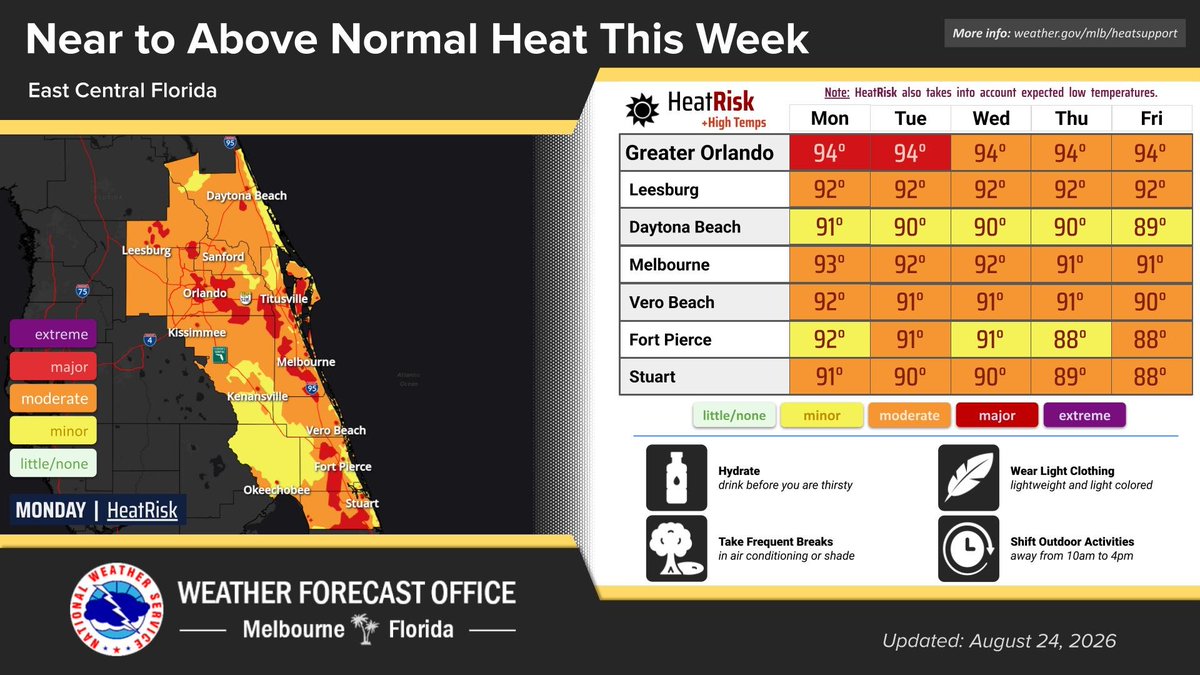
🌡️ Heat: Highs will generally reach the low 90s, but humidity will push heat indices into the 100–105°F range, with isolated locations potentially approaching 107°F. HeatRisk remains mostly Minor to Moderate, with localized Major HeatRisk possible.
📅 Looking ahead: Friday remains active with scattered to numerous storms. Saturday through Monday stays seasonably hot with daily thunderstorms, although activity should increasingly favor the interior as the Atlantic sea breeze moves inland.
🌊 Beaches: A Moderate rip-current risk continues. Swim near a lifeguard and use extra caution in the surf.
🌀 Tropics: The central/eastern Atlantic disturbance AL96 remains worth monitoring, but the graphic indicates no specific tropical concerns for east-central Florida right now. Its development and eventual track remain uncertain.
📍 Vero Beach takeaway
Expect roughly 91°F today, a heat index near 101°F, and about a 50% chance of thunderstorms. The greatest concern is during the afternoon and evening, when storms could bring dangerous lightning, gusty winds and very heavy localized rainfall.
Bottom line: 🌡️ Heat in the morning → ⛈️ storms during the afternoon/evening → 🌧️ localized flooding possible. Keep an eye on AL96, but there is no immediate tropical threat to the Treasure Coast.
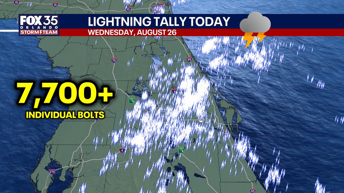
Tremendous lightning tally Wednesday from across central Florida... sea-breeze collision finally occurred to produce big rain totals around the immediate Orlando area.
Here are the afternoon ensembles (Euro AI, Euro, GFS, Google Deep Mind) for 96L the next 10 days. No real signal for any one area anymore. Just something to keep watching.
🌴 Atlantic Tropical Weather Summary — August 27, 2026
The main feature to watch is Invest AL96 in the eastern tropical Atlantic. The disturbance is moving quickly west to west-northwest at around 20 kt. Thunderstorm organization has improved somewhat, but the circulation is not yet well defined.
🌀 Invest AL96
Located several hundred miles west-southwest of the Cabo Verde Islands.
Environment is somewhat favorable for development during the next 1–2 days.
A tropical depression could form before conditions become less favorable this weekend.
The NHC currently gives it a medium development chance.
Increasing winds and rougher seas will accompany the system as it crosses the tropical Atlantic.
The longer-range model guidance shown in the graphic generally supports a continued westward track toward the Lesser Antilles, but uncertainty becomes very large afterward. Some ensemble members eventually turn the system northward over the western Atlantic, while others carry it farther west. At these long ranges, those individual tracks should not be interpreted as forecasts for Florida.
🌊 Caribbean Gale Warning
A much more immediate marine hazard exists in the south-central Caribbean. Strong high pressure north of the Caribbean interacting with lower pressure over Colombia is producing powerful easterly trade winds.
Gale-force winds of 30–35 kt are expected to pulse off Colombia and through portions of the Gulf of Venezuela, with significant seas reaching roughly 11–15 ft (3.5–4.5 m). Fresh to strong trades and rough seas extend across a much larger portion of the central Caribbean.
🌎 Rest of the Tropics
Two additional tropical waves are moving rapidly westward—one near 62°W crossing the Lesser Antilles and another near 78°W in the central Caribbean. Neither is producing significant organized deep convection. Another wave crossing the Yucatán is enhancing thunderstorms there.
The Gulf of America is comparatively quiet, with weak high pressure producing light winds and generally slight seas.
📍 Florida / Treasure Coast Takeaway
There is no immediate tropical cyclone threat to Florida indicated by the current NHC outlook. AL96 remains thousands of miles away, and its eventual track and intensity are highly uncertain.
The important window is the next 48 hours: whether AL96 develops before environmental conditions deteriorate this weekend will help determine what survives into the western Atlantic.
Bottom line: 🟡 AL96 bears watching, but there is no reason for alarm in Florida at this stage. The Caribbean gale is the most significant immediate marine hazard, while AL96 is the system with the greatest longer-term interest.
East Central Florida Weather Summary — Thursday, Aug. 27
A typical late-summer pattern continues across east-central Florida, with hot, humid conditions and active afternoon thunderstorms.
⛈️ Today & Friday: Scattered to numerous afternoon/evening storms with 50–70% rain chances. Storms may produce frequent lightning, 45–55 mph wind gusts, and torrential rainfall. Local totals near 3 inches could cause temporary urban or poor-drainage flooding.
🌡️ Heat: Highs generally 91–93°F, with peak heat indices around 100–106°F.
📍 Vero Beach: Around 91°F today, with roughly a 50% rain chance. Friday remains near 91°F, with rain chances around 40%.
🌊 Weekend into next week: Increasing onshore/easterly flow will push the Atlantic sea breeze inland faster. Thunderstorms should increasingly favor the interior and Orlando area, while immediate coastal locations such as Vero Beach may see somewhat lower afternoon rain chances.
🌙 Coast: Persistent onshore flow may keep nighttime temperatures quite warm this weekend and next week, generally upper 70s to lower 80s.
🚤 Marine: Favorable overall—seas 1–2 ft through Friday, increasing to 2–3 ft this weekend. Offshore-moving storms today and Friday could still produce sudden strong wind gusts.
⚠️ No watches, warnings, or advisories are currently in effect.
Bottom line for the Treasure Coast: Today and Friday carry the greater thunderstorm threat, especially during the afternoon and evening. By the weekend, the pattern shifts toward earlier inland-moving storms and somewhat quieter conditions near the immediate coast, while hot and humid weather continues.
Aug 26 | High coverage of rain/storms later today into this evening with best chances over the interior counties. Primary storm threats are frequent lightning, gusty winds up to 55 mph and very heavy rain. Locally, a quick 2-3" are possible mainly over portions of the interior.
🌴 Atlantic Tropical Weather Summary — August 26, 2026
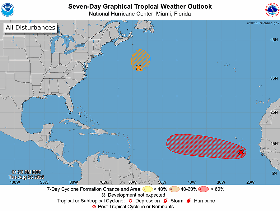
The main tropical feature is Invest AL96 in the eastern tropical Atlantic, several hundred miles southwest of the Cabo Verde Islands. Thunderstorms remain somewhat displaced from the center, but conditions are favorable enough for gradual organization, and a tropical depression is likely to form within the next day or two as AL96 moves west to west-northwest.
AL96 remains far from Florida, so there is no immediate threat to the state. Longer-range guidance shows considerable uncertainty, making it too early to determine whether the system will eventually approach the western Atlantic or turn northward.
Elsewhere, the south-central Caribbean is the most hazardous marine area. Gale-force trade winds around 30–35 knots are occurring near the Gulf of Venezuela and northern Colombia, accompanied by rough to very rough seas. Fresh to strong trade winds and elevated seas extend across much of the central Caribbean.
The Gulf of America is relatively quiet, dominated by weak high pressure, generally light to moderate winds, and seas around 1–3 feet.
🌀 Bottom Line
AL96 is the system to watch. Development into a tropical depression appears increasingly likely in the short term, but its eventual track and intensity remain uncertain. For Florida, this is currently a monitor—not panic—situation, with plenty of time to watch how the system develops over the central Atlantic.
Central Florida Weather Summary — Wednesday, Aug. 26
A stormy summertime pattern continues across east-central Florida through Friday. Scattered to numerous afternoon and evening thunderstorms are expected, with 50–70% coverage. The main hazards will be frequent lightning, 45–55 mph wind gusts, torrential downpours, and localized flooding. A few locations could receive around 3 inches of rain.
Temperatures remain seasonably hot and humid, with afternoon highs generally 90–95°F and heat indices around 100–105°F. For Vero Beach, expect a high near 91°F today with about a 50% storm chance, increasing to around 60% Thursday.
By the weekend into early next week, winds become more easterly/onshore. The Atlantic sea breeze should push farther inland, shifting the greatest thunderstorm coverage toward Orlando, Kissimmee, and the interior, while coastal areas such as Vero Beach and Melbourne may have somewhat better chances of staying dry.
Marine conditions are favorable overall: seas 2 feet or less through Friday, increasing to 2–3 feet this weekend. However, thunderstorms could produce sudden strong wind gusts over the Atlantic waters through Thursday.
Bottom line: Wednesday through Friday will bring the greatest widespread storm coverage. Expect hot, humid mornings followed by thunderstorms during the afternoon and evening. The pattern shifts inland this weekend, potentially bringing some improvement along the Treasure Coast.
No changes with the 2 PM tropical weather outlook. #95L well NE of Bermuda remains at 40% development chances and #96L in the MDR remains at 70% development chances.
🌊 Atlantic Afternoon Full-Run Summary
The overall message from this long-range guidance is that the Atlantic remains favorable for tropical activity, but there is substantial uncertainty about which disturbances actually develop and where they ultimately track.
Warm Atlantic: Sea-surface temperatures are above normal across much of the tropical and subtropical Atlantic. That provides plenty of oceanic heat for systems that encounter favorable atmospheric conditions.
Multiple disturbances: The guidance depicts several tropical waves/lows progressing westward from Africa across the Main Development Region. Not every modeled low should be interpreted as a future named storm.
Western Atlantic is the area to watch: Several solutions bring disturbances toward the Caribbean/Bahamas before eventually turning northward. Other solutions recurve considerably earlier.
Florida signal: Some long-range tracks get into the general Florida/Bahamas vicinity, but the ensemble spread is far too large to suggest a Florida landfall. The more important signal is that the western Atlantic could become active.
Recurvature remains prominent: A substantial number of ensemble members eventually turn systems north and northeast into the open Atlantic, suggesting weaknesses in the subtropical ridge may provide escape routes.
Intensity potential exists: Some individual solutions become quite strong, but at this range those extreme pressure/intensity forecasts have very low confidence and shouldn't be taken literally.
🌀 Bottom line
This is more of an “active Atlantic pattern” signal than a specific hurricane forecast. The combination of warm water, repeated tropical waves and multiple ensemble members developing lows makes the late-August into early-September period worth watching closely.
For Florida and the Southeast, there's no reliable direct-impact signal yet. The key question over the coming runs is whether ensemble tracks begin clustering consistently near the Bahamas/Florida, or increasingly consolidate on an earlier recurvature east of the U.S.
Confidence: Moderate that the Atlantic becomes increasingly active; low confidence on any individual storm's development, strength or U.S. impact this far out.
12:47 PM, Tue. Aug. 25th | Increasing moisture across the I-4 corridor will bring higher rain chances and slow-moving storms capable of heavy rainfall. Areas could receive 1-3" rainfall amounts in a relative short period, with localized 4-5" amounts possible into this evening.
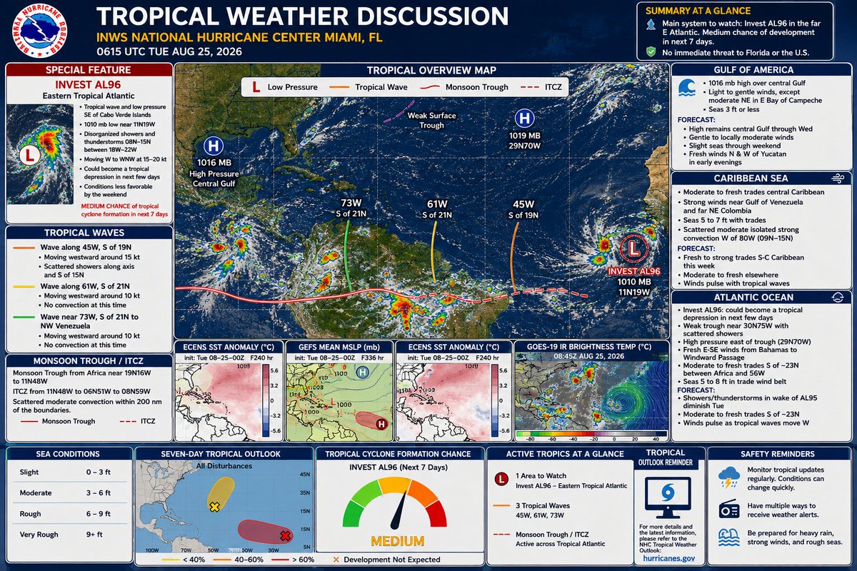
🌀 Tropical Atlantic Summary — August 25, 2026
The main system to watch is Invest AL96 in the far eastern Atlantic, southeast of the Cabo Verde Islands. It has a medium chance of becoming a tropical depression during the next several days while moving west to west-northwest at about 15–20 kt. Conditions may become less favorable by the weekend.
🌴 For Florida: There is no immediate tropical threat shown. AL96 remains thousands of miles away, so the key is simply to monitor its development and eventual track over the coming days.
Three additional tropical waves are moving westward:
45°W: Producing scattered showers, but no organized development.
61°W: Little or no significant convection.
73°W: Moving through the Caribbean toward northwestern Venezuela with little organized convection.
🌊 Caribbean: Fresh to strong trade winds continue across the south-central Caribbean, particularly near Colombia and Venezuela, with seas around 5–7 ft. Tropical waves will periodically enhance the winds.
☀️ Gulf: High pressure dominates, keeping conditions relatively quiet with light to gentle winds and seas generally 3 ft or less.
📡 Model picture: The longer-range ensemble guidance shows considerable track spread, which is normal this far out. Some solutions eventually curve systems northward over the western Atlantic, but there is far too much uncertainty to interpret individual tracks as a Florida forecast.
Bottom line
🟠 AL96 deserves watching, not worrying. The tropical Atlantic is becoming more active as we approach the climatological peak of hurricane season, but nothing shown here represents an immediate hurricane threat to Florida. The next several days should tell us much more about whether AL96 can organize and what steering pattern it ultimately encounters.
East-Central Florida Weather Summary — Tuesday, Aug. 25
⛈️ Storm coverage increases today, especially around Orlando and the I-4 corridor, where rain chances reach 50–70%. Along the Treasure Coast, including Vero Beach and Fort Pierce, coverage is lower at roughly 20–40%, with storms developing near the sea breeze during the afternoon.
⚠️ Strong storms are possible. The biggest concerns are 40–50 mph wind gusts, frequent lightning, torrential downpours, and localized urban flooding. Activity should diminish later tonight.
🌡️ Hot and humid: Afternoon temperatures will reach the low to mid-90s, but humidity will push heat indices to around 100–107°F.
📅 Wednesday through Friday: Moisture increases and brings a more typical active summer pattern. Expect 50–70% rain chances each day, with scattered to numerous afternoon/evening thunderstorms. Lightning, 40–45 mph gusts, and localized flooding remain the main hazards.
🌴 Weekend: Typical late-August Florida weather continues—hot, muggy, and scattered to numerous afternoon storms. A developing onshore flow may shift the greatest storm coverage farther inland.
🌊 Marine: Generally favorable outside thunderstorms. Seas remain below 2 ft through early Friday, increasing to 2–3 ft this weekend. Afternoon sea breezes may produce southeast winds around 15 kt. Offshore-moving thunderstorms could cause sudden strong winds and rougher seas.
Vero Beach focus: Around 92°F today, with relatively limited storm coverage initially. Rain chances increase substantially Wednesday and beyond. The combination of heat, lightning, and locally heavy rainfall will be the main concerns for the rest of the work week.
Aug 24 | Scattered afternoon and evening storms today, best chance over the interior late afternoon/early evening associated with the sea breeze collision. Hot and humid conditions will produce peak heat indices 102 to 107. Stay well hydrated if working or recreating outdoors!