@sidlal Hi.
My is Dasharath Hurakannavar I am from Dharwad and I have Himalaya 411, purchased in 2023 less than 2 years my Bike Breakdown 3 times and Engine Head was charged 2 times but @royalenfield not taking any action. Simply changing engine head they don't have any solution.
@sidlal Hi.
My is Dasharath Hurakannavar I am from Dharwad and I have Himalaya 411, purchased in 2023 less than 2 years my Bike Breakdown 3 times and Engine Head was charged 2 times but @royalenfield not taking any action. Simply changing engine head they don't have any solution.
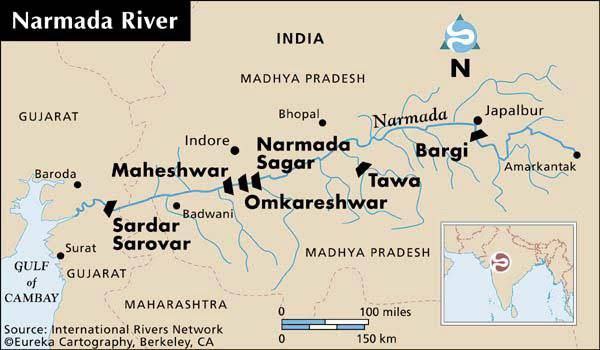
🔴 Narmada River
▪️It is located mainly in Madhya Pradesh.
▪️The Narmada River is also known as the Rewa River.
▪️The River is originated from Maikala range near Amarkantak.
▪️It is a West flowing river.
▪️The River flows through Gujarat, Chhattisgarh Madhya Pradesh, and Maharashtra.
▪️Its total length from its source in Amarkantak to its estuary in the Gulf of Khambhat is 1,310 km
▪️The tributaries of Narmada River are Kolar River, Shakkar River, Dudhi River, Tawa River, and Hiran River.
▪️Major Hydro Power Project in this river are Maheshwar Dam, Sardar Sarovar Dam, and Indira Gandhi Sagar Dam
▪️ To Hindus the Narmada is one of the seven holy rivers of India; the other six being Ganges, Yamuna, Godavari, Saraswati, Sindhu, and Kaveri.
▪️There are several islands in the estuary of the Narmada of which Aliabet is the largest
▪️ Narmada rivers fall into the Arabian Sea do not form deltas, but only estuaries
#UPSC #UPSCPrelims2024 #river
🔵 Why In news?
🔺Majuli, covering an area of around 352 square kilometres, is constantly changing its shape due to erosion and sedimentation.
🔵 About Majuli Island -
🔺 Majuli means ‘the land between two parallel rivers’.
🔺Majuli is the world’s largest river island according to Guinness World Record & situated on the Brahmaputra River in Assam.
🔺It sprawls over an extensive area of 352 sq km.
🔺It is formed by the Brahmaputra River in the south and the Kherkutia Xuti joined by the Subansiri River in the north
English Channel:
🔸It is an arm of the Atlantic Ocean that separates southern England from northern France.
🔸It is connected to the southern part of the North Sea through the Strait of Dover at its northeastern tip.
🔸It is about 560 km long and varies in width from 240 km at its widest to 34 km in the Strait of Dover. It is the busiest shipping area in the world.
🔸It was a key factor in Britain becoming a naval superpower and has been utilised by Britain as a natural defence mechanism and prevented invasions, such as the Napoleonic Wars and those of Adolf Hitler in World War II.
🔸The two dominant cultures are English on the north shore of the Channel, and French on the south.
There is a 50.46-kilometre undersea railway tunnel known as Channel Tunnel.
🔸It was opened in 1994 and connects Folkestone ( England) with Coquelles (France) beneath the English Channel at the Strait of Dover.