Hey @tvland , how about you stop plastering ads over the screen and blocking actors faces. This is ridiculous. You show no respect for "classic" shows.
Breezy conditions with passing showers for the next few days... before "January" makes a come back later in the week. A stronger front catches us by Thursday afternoon.
The change in the air will be noticeable starting Friday morning.
After voting to give billionaires tax breaks and making health care more expensive, Derrick Van Orden has refused to hold a town hall to talk to the voters he works for in a face-to-face conversation. So, I'm heading to Wisconsin to help give the people he's supposed to represent a voice. https://t.co/VcD3OoXZfm
Cooler and drier air swiftly advancing across South Florida this morning. It feels great out!
A legit front has finally arrived and will set us up for outstanding weather over the next several days.
Tuesday 8pm - Melissa's pressure up 29 mb since 5pm... now a category 3 with 125 mph winds. The system is still forecast to approach Cuba as a category 4 tomorrow. @nbc6
The stretch of shoreline from Black River to Treasure Beach will take the brunt of Melissa’s wrath.
200+ mph wind gusts
Deadly storm surge
Total structural failure
Feet of rain
"LAST CHANCE TO PROTECT YOUR LIFE."
I've never seen the National Hurricane Center say this.
Melissa is now the 5th most-intense Atlantic hurricane ever recorded, making landfall at the same strength that Dorian did in the Bahamas. 2.8 million lives will change in moments.
#Melissa is an 896 mb, 180 mph cat. 5, doing everything right in the atmosphere, which will have catastrophic consequences for #Jamaica.
It's incredible that the absolute ideal conditions allowed for this structure and sustained (if not growing) intensity.
So rare.
Godspeed🇯🇲
Today is a grave, grim day. The sun just rose in Jamaica. This is the last time the landscape will look as it does today.
About 40% of the island is about to lose most of its vegetation; the landscape will be deforested and defoliated. The scar etched in the landscape will take a decade or more to heal.
The EYEWALL is approaching. It's still replete with lightning, suggesting a storm maintaining intensity or even strengthening. The innermost buzzsaw of winds will bring tornado-like conditions for up to 3 HOURS. Most well-built structures will be severely damaged or destroyed. Flying debris will become lethal missiles. Compact cars and smaller SUVs will be lofted. High-rise and multi-story apartment buildings will lose all windows and some sections of roofs and walls; a few may sway dangerously, perhaps to the point of total collapse.
For those in the eyewall zone, SEEK SHELTER! Move to a basement or interior room on the lowest floor of your home or business that can't flood.
Once the leading edge of the eyewall passes, be aware that the winds will switch direction.
Whether you're an introvert or an extrovert, strong social skills are crucial for building meaningful relationships and advancing in your career.
Here are four tips to help you level up your social skills! #socialize#putyourselfoutthere#gettingoutofyourcomfortzone
WATCH: The JICA Early Warning System issued an evacuation message at 2:43 p.m. today for residents of Old Harbour Bay, St Catherine.
Rising sea levels have begun flooding homes, roadways, and parts of the fishing village. Parish Disaster Management officials are currently monitoring the situation and urging residents in low-lying areas to take precautionary action.
https://t.co/VxFToMcdH9
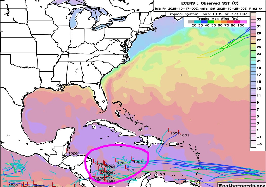
As discussed all week, now we have a couple areas to watch as we get past October’s midpoint. The southern system is the only one of interest to the USA as it could get pulled north. As to how close it comes to the USA mainland, it’s anyone's guess at this point, but the farther west it gets and potentially develops the farther east it has to go to clear the southeast if it comes north. This cat and mouse game should take about the rest of the month to complete since this disturbance could get caught in the Caribbean or Greater Antilles while the steering evolves. As of right now we have no USA threat it is merely something to watch.
Latest model solutions (a week from today) are interesting as EURO buries it, GoogleDM curves it north early with intensity, and GFS has it along with a system from the CAG hanging out in the Caribbean. Should be a fun week watching this. Expect unsettled weather in the Lesser Antilles this weekend with its passage as potentially a named storm as some guidance has developed it earlier. This is reflected with NHC's latest cone.