@80triph The apple maps image is from Nov 2025.
Located at 35.08211° N, 75.51740° E this site was ready in early 2022, its not a recent update at all.
Admin/C2 callouts need verification or proof of concept as well. Nature of radar is unknown in the analysis as well.
If you look closely at the image shared, you can see the plane is fitted with pods on its wings, just like the Iranian Air Force RC-130H Khofash, these are likely for its EW role.
@mowjit What’s impressive is the thickness of the bubble you live in. Even a knowledge-bearing BrahMos would ricochet off those walls. Don’t be shocked when you step outside and discover reality is miles away from the fantasy you’ve been living.
1/ It’s genuinely impressive how the noisiest people discussing satellite imagery seem to have absolutely zero background in GEOINT, remote sensing, or commercial tasking workflows & yet they manage to write entire essays packed with nonsense
This discussion is a little confused. My understanding is Maxar did limit access to images of Indian facilities during and in the immediate aftermath of the hostilities but with assurances to journalists that they were doing so because no damage was visible. But… /1
@clary_co It's that understandable beginning that doesn't make sense, people want to believe shutter control existed, but the facts don’t support it. If access was supposedly restricted, how did PAF present pre-strike Adhampur imagery and post-strike Udhampur imagery during their presser?
@clary_co Also, IF Maxar was locked out - multiple other providers, including Chinese firms, released imagery as well, & they too found no visible damage at the locations Pakistan claimed were hit, did Planet, Satellogic etc everyone decide to turn their backs on Pakistan ?
@clary_co If Maxar had formally restricted imagery sharing in India’s favour, there would be written evidence from Maxar itself, or from whoever engaged with them, explicitly citing security restrictions. None has surfaced.
Are you able to provide this formally ?
6/ Hence its far easier to write a clueless article & have a cognitive blackout despite researchers routinely identifying strike damage even under far stricter conditions, including US-imposed shutter control restrictions on imagery related to Middle East conflicts.
5/ If Pakistan had actually tasked imagery, those scenes would exist in commercial archives. OSINT researchers, media, or independent GEOINT analysts would eventually find & publish them. But that would require real targets, visible damage, proper analysis, & actual effort.
@clary_co@ParveenKaswan Has this someone ever actually published imagery analysis, worked in a credible GEOINT environment, or conducted any serious geospatial media investigations? ... because there’s a staggering amount of imagery commentary circulating from people who know nothing about imagery ..
The volume of accounts abruptly presenting themselves as geospatial imagery specialists, OSINT experts, or dedicated intel channels after Operation Sindoor on both sides is becoming difficult to ignore, engagement farming clowns now masquerade as analysts 🤡
At the ISPR book launch documenting Pakistan’s version of the May 2025 conflict, fake satellite imagery was presented on the main stage, the displayed image showed superimposed explosions layered onto Google Earth imagery from 2020 of Barnala Airbase 🤡
The ISPR documentary itself says S-400 "reportedly" neutralized - implying the claim is not independently verified and is based on initial or secondhand reports rather than confirmed evidence !
From misinterpreted images showing "hits" to rubbish claims of taking out an S-400 unit, Pak's info warfare dept is on overdrive - as the 1st anniversary arrives.
For the real S-400 story, read my book, 'The Sky Warriors: Op Sindoor Unveiled' available on Amazon: https://t.co/XmwaphWm0B
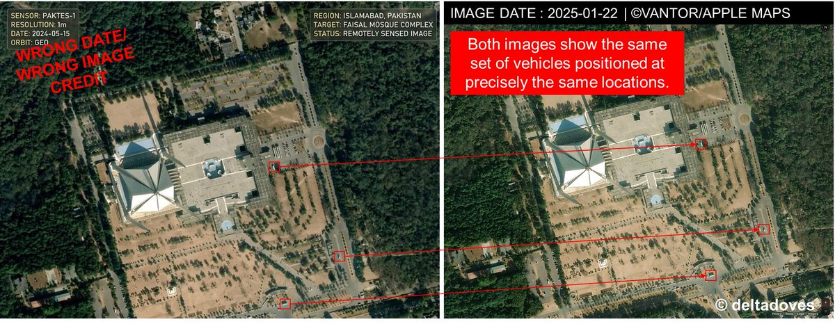
Pakistan-based handles continue to push fabricated sat imagery, now asserting a Pakistani EO satellite imaged Faisal Mosque in Islamabad, in reality the image is sourced from Apple Maps 🤡
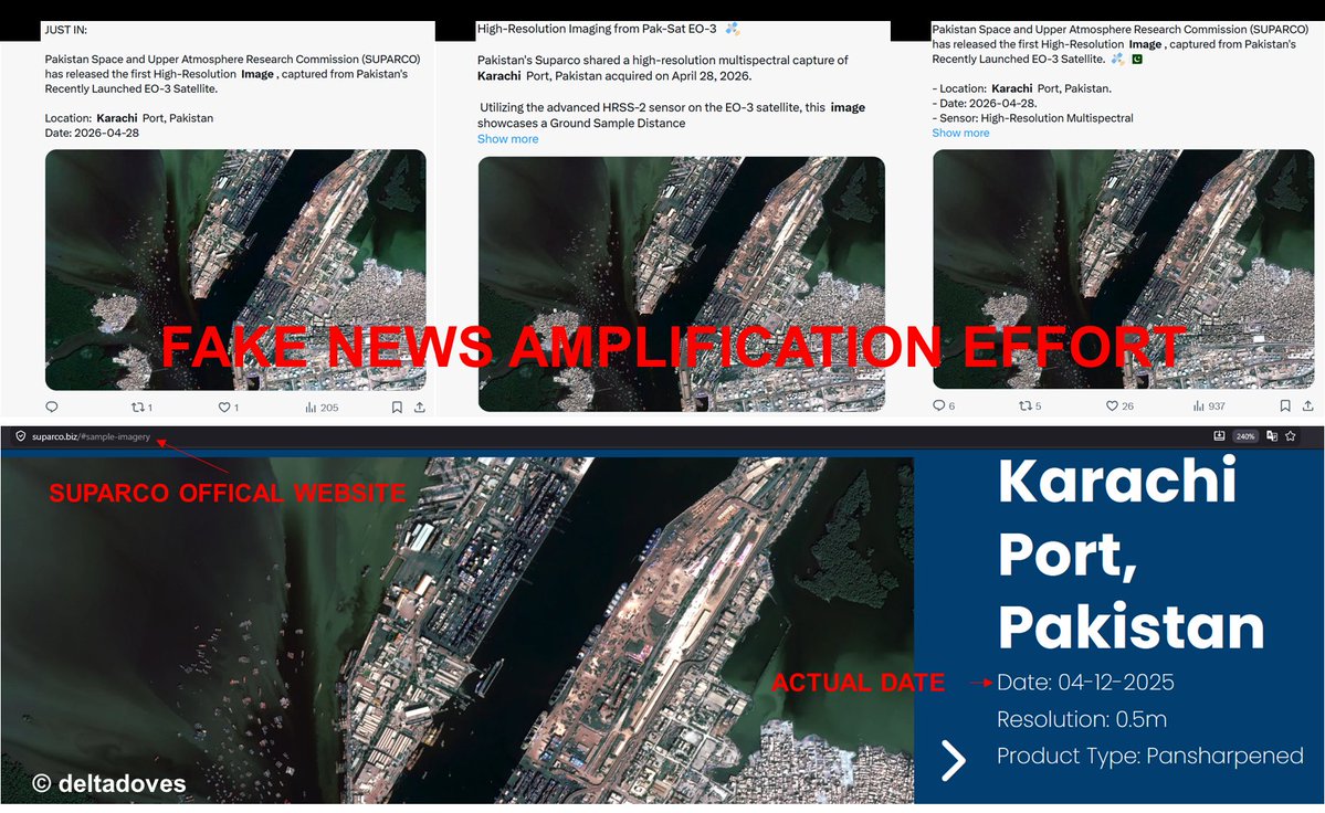
Multiple Pakistan based accounts are circulating imagery of Karachi Port, presenting it as the "first high resolution capture from the recently launched EO-3 satellite" - however the image originates from SUPARCO’s own website & is dated Dec 2025 🤡
Container ship BLUE STAR 3 (IMO: 9133147) was boarded by a US Marine Expeditionary Unit while departing Pakistan's Gwadar Port. The vessel was underway to Oman's Sohar Port at the time of the boarding. The operation was conducted within Pakistan's Exclusive Economic Zone.