@TornadictWx I don't use twitter for sharing a bunch of information about the storm. My main source for all of my information has always been my Facebook page, which has 6,000 followers. Twitter is a side platform for updates on the go (mainly for Severe Weather in Denton County).
@SlushyWx Did I ever mention I was better than the NHC in that video? Did I ever mention that I used the HWRF in that video? Absolutely not. You should watch it instead of making false statements.
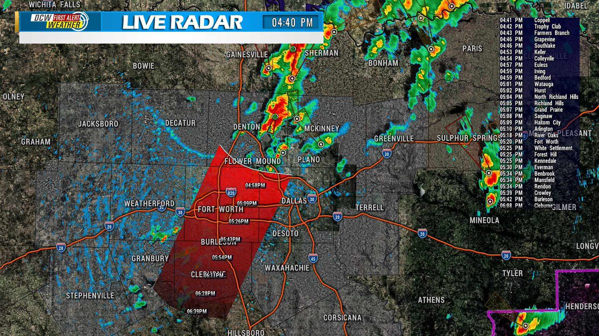
ALERT: A storm just to the NE of Denton County is very slowly tracking towards our area. I do not expect it to live for much longer, but here's the track & timing if it does.
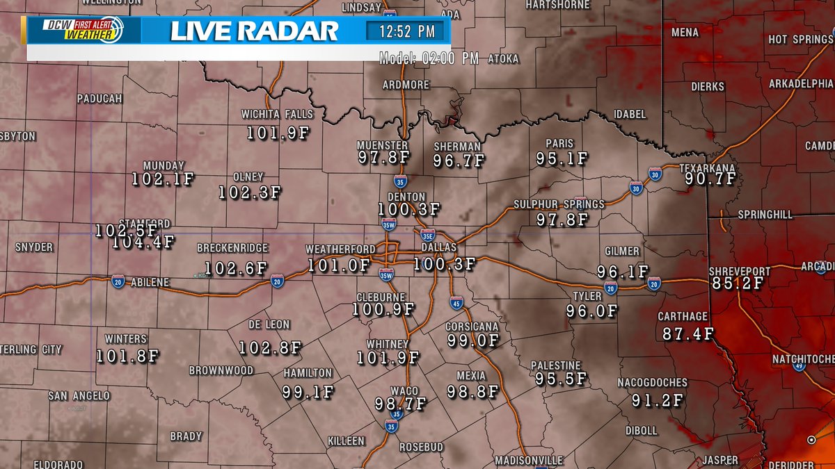
CHANCE OF STORMS: Here is your chance for a downpour or strong to severe storms this afternoon. Most of us will see nothing, however, due to how hot it'll be today, the temperature may just get warm enough to bypass the cap's temperature, bringing us storms.
DAMAGE FROM MICRO BURST OR TORANDO: Here are some of the recent damage photos sent to us from a potential microburst or tornado near Robson Ranch & Northlake, TX, around 5-5:30PM. If you have any, please send them to our DMs.
@dfwstormchasers Most likely. Still hard to say since I have seen people posting about things flying up and coming down, like a trampoline into another persons yard (over a fence), bouncy houses (which can be from any wind), etc.
This is very difficult to tell from this distance, but this could of been a tornado or funnel cloud. Otherwise, this was likely a microburst. Lots of damage reports tonight, I do have pictures up on our Facebook page. Keep messaging me with any pictures or videos! #DentonCounty
🙁 This is the Radar Station I was using last night for the live radar on the live streams. The radar is completely destroyed. The radar completely shut off right when the hurricane made landfall.
TROPICS UPDATE: Hurricane Laura is now a low-end Category 2 Hurricane, with sustained winds near 98 MPH. Over the next hour or so, it'll drop to a Category 1. Flooding rains are likely with this storm. Here in DFW, a few spotty showers or storms are possible this afternoon (20%).
TROPICS UPDATE: Laura is set to make landfall around 1-2AM, as a Category 4 (155 MPH) or Category 5 (160 MPH). Regardless of category, this will be a very catastrophic storm. Make sure you take this seriously. This is the last update tonight, we will post more updates tomorrow.
**BREAKING** - Laura is expected to make landfall as a Category 5 Hurricane in 6 hours, with sustained winds near 160 MPH, and wind gusts near 195 MPH. THE TRACK HAS SHIFTED WEST and looks to make landfall near PORT ARTHUR, TX. Make sure to share this with people in the track.
**TROPICS UPDATE**: The track has shifted the slightest bit to the west, only by about 10 miles. This is a very dangerous situation and you must evacuate if you are near the coastline. Share this with your friends so they are aware. (PS: Pink area = Tornado Watch)
LIVE RADAR UPDATE: Storms along an outflow boundary continue to push south.
(PS: Apologies for lack of updates on storms, I have over 25000 shares on my last facebook post and 2000+ comments, very hard to keep up)
@DamienC32491564 Yes but I am saying Category 5 at landfall. I predicted 4 days ago it would become at least a Category 4. I don't have to agree with the NOAA if I believe something else will happen.
**BREAKING** Laura is now a Category 4, and set to make landfall as a Category 5. Unsurvivable Storm Surge & Wind Gusts over 190 MPH are expected on immediate landfall. The track is not changed. Share this with anyone in the track of the storm. #TropicsUpdate#HurricaneLaura