Residents of Metro Manila, here are the emergency hotlines for your respective cities.
Keep safe and please remember not to leave your pets behind. 1/2
#CarinaPH#emergencyhotlines
Thunderstorm Advisory No. 1 #NCR_PRSD
Issued at: 9:50 AM, 28 August 2025(Thursday)
Moderate to heavy rainshowers with lightning and strong winds are expected over Quezon, Laguna, Batangas and Zambales within the next 2 hours.
All are advised to take precautionary measures against the impacts associated with these hazards which include flash floods and landslides.
Keep monitoring for updates.
#TropicalDepressionUpdate: Alas-8:00 ng umaga, Agosto 28, 2025, naging Tropical Depression “𝐉𝐀𝐂𝐈𝐍𝐓𝐎” na ang Low Pressure Area (LPA 08g) sa West Philippine Sea. Hinihikayat ang lahat na patuloy na magbantay para sa mga update mula sa @dost_pagasa.
#IntegratedStateMedia#ISM
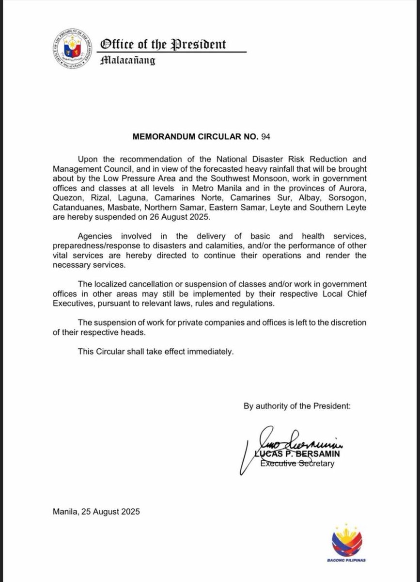
#Walangpasok bukas, Agosto 26, 2025, Martes, sa lahat ng antas sa pampubliko at pribadong paaralan, at sa mga tanggapan ng pamahalaan sa mga nabanggit na lugar dahil sa masamang panahon ayon sa PAGASA:
• Metro Manila
• Aurora
• Quezon
• Rizal
• Laguna
• Camarines Norte
• Camarines Sur
• Albay
• Sorsogon
• Catanduanes
• Masbate
• Northern Samar
• Eastern Samar
• Leyte
• Southern Leyte
Pinapaalalahanan ang lahat na mag-ingat, umiwas sa mga mapanganib na lugar, at patuloy na sumubaybay sa mga opisyal na abiso ng pamahalaan.
Sources: Presidential Communications Office
#NDRRMC
#BawatSegundoMahalaga
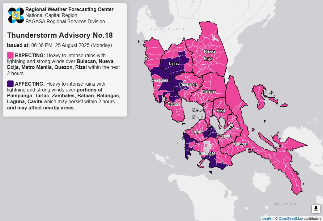
Thunderstorm Advisory No. 18 #NCR_PRSD
Issued at: 6:36 PM, 25 August 2025(Monday)
Heavy to intense rainshowers with lightning and strong winds are expected over Bulacan, Nueva Ecija, Metro Manila, Quezon and Rizal within the next 2 hours.
The above conditions are being experienced in Pampanga(Floridablanca, Porac, Guagua, Santa Rita, Bacolor), Tarlac(Capas, Bamban, San Jose, Tarlac City, Gerona), Zambales(San Marcelino, Subic, Botolan), Bataan(Dinalupihan, Hermosa), Batangas(Nasugbu, Lian, Calatagan, Balayan, San Pascual, San Jose, Batangas City, Ibaan, Bauan, Lobo), Laguna(Cabuyao, Santa Rosa, Calamba, Binan) and Cavite(Silang, Carmona) which may persist within 2 hours and may affect nearby areas.
All are advised to take precautionary measures against the impacts associated with these hazards which include flash floods and landslides.
Keep monitoring for updates.
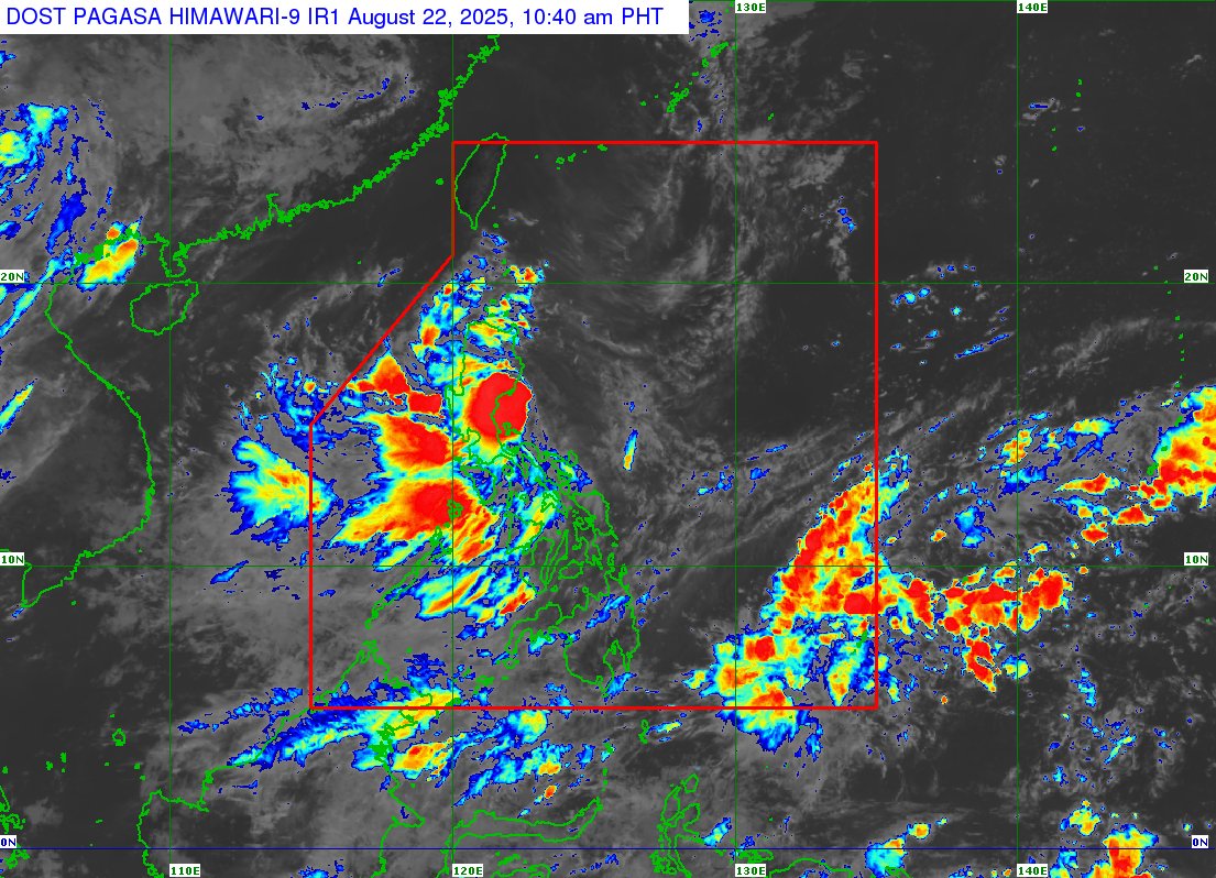
Itinaas na sa BLUE Alert Status ang NDRRMC batay sa Memorandum 214, s. 2025, epektibo 12 nn, ngayong araw, Agosto 22, 2025, dahil sa banta ng Tropical Depression #IsangPH.
Layunin nito na mapabilis ang koordinasyon ng mga ahensya at tanggapan para sa agarang disaster response.
PAGASA: (10:30AM) Yellow Rainfall Warning is raised over Metro Manila.
Flooding is possible in flood-prone areas.
All are advised to stay updated with the latest weather bulletins from @dost_pagasa#WeatherAdvisory#WeatherUpdate#IsangPH#PAGASA
#LibrengSakay sa MRT-3, LRT-1 at LRT-2
Kasunod ng suspensyon ng klase dahil sa inaasahang malakas na pag-ulan sa ilang lugar sa Metro Manila, iniutos ni Pangulong Ferdinand Marcos Jr., na magpatupad ng libreng sakay simula 12:00 ng tanghali ngayong araw, August 22, 2025.
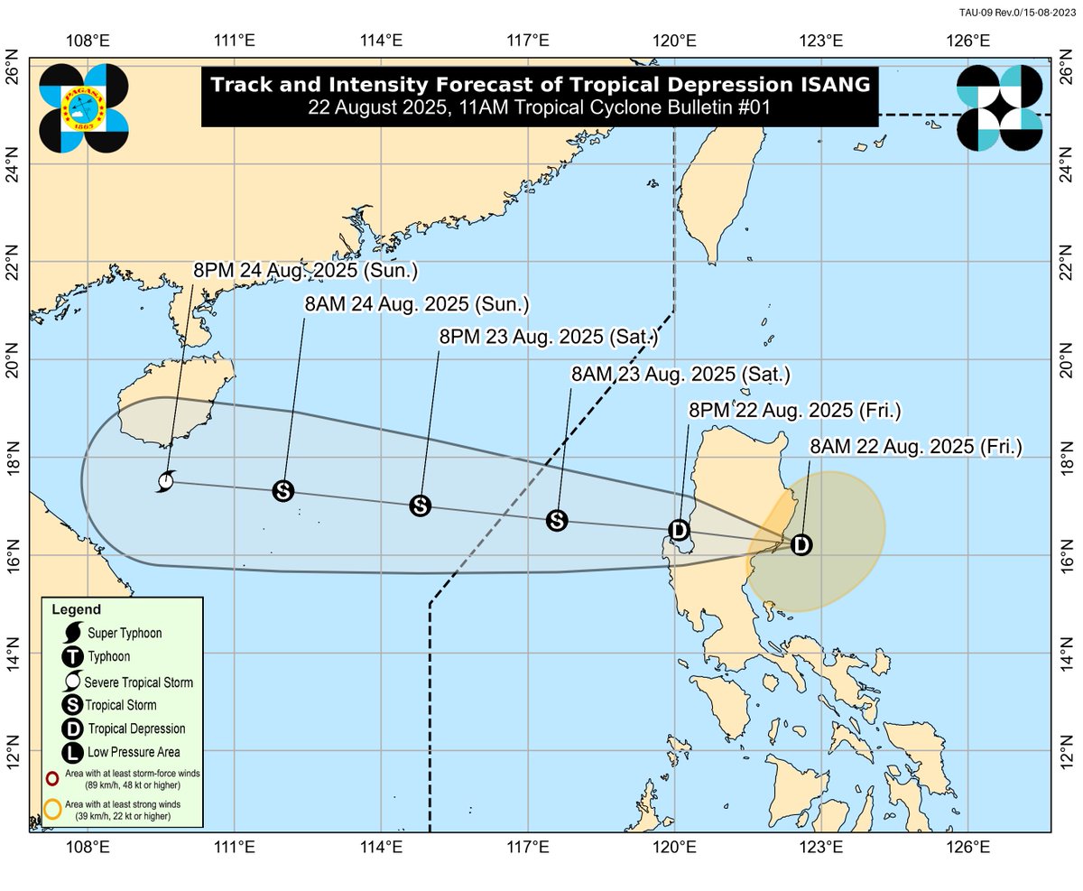
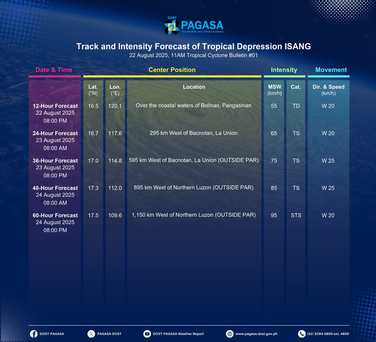
TROPICAL CYCLONE BULLETIN NR. 1
Tropical Depression #IsangPH
Issued at 11:00 AM, 22 August 2025
Valid for broadcast until the next bulletin at 2:00 PM today.
THE LOW PRESSURE AREA EAST OF AURORA HAS DEVELOPED INTO TROPICAL DEPRESSION ISANG AND MADE LANDFALL OVER CASIGURAN, AURORA
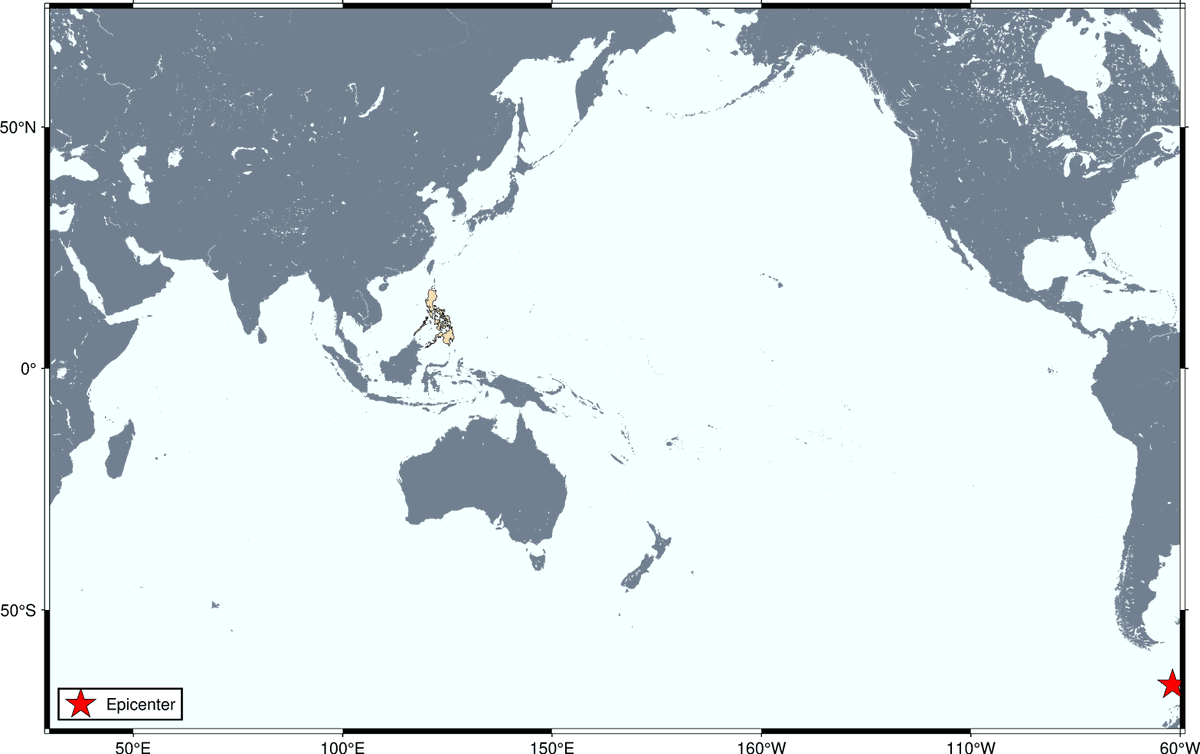
#TsunamiPH
ADVISORY: NO TSUNAMI THREAT TO THE PHILIPPINES
Tsunami Information No.1
Date and Time: 22 Aug 2025 - 10:16 AM
Magnitude = 7.5
Depth = 011 kilometers
Location = 60.19°S, 61.82°W - Drake Passage
https://t.co/8bZwy2yoei
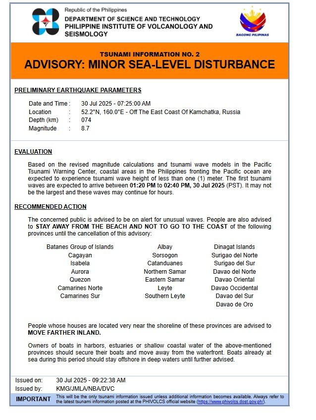
🚨 Tsunami Advisory
According to @phivolcs_dost, waves less than 1 meter may hit coastal areas in the Philippines fronting the Pacific Ocean between 1:20–2:40 PM PST, July 30.
🚫 Stay away from the shore.
🏃♂️ Move inland if near the beach.
Follow the instruction of authorities.
As of 8AM, July 24, 2025: #EmongPH (CO-MAY) has intensified into a Typhoon and remains inside the PAR.
Meanwhile, Tropical Storm #DantePH (FRANCISCO) is still being monitored within the PAR.
The, LPA 07i outside PAR has developed into a tropical depression.
#IntegratedStateMedia
LA MESA DAM UPDATE: As of 11:10 AM, the water level of La Mesa Dam is at 79.62 meters and is now BELOW OVERFLOW LEVEL.
Critical level is at 79.50 meters while its spilling level is at 80.15 meters.
#Habagat#DantePH#EmongPH#LaMesaDam
IN PHOTOS: President Ferdinand R. Marcos Jr., with DSWD Sec. Rex Gatchalian and local officials, visited evacuees in San Mateo, Rizal on July 24.
They distributed family food packs, essential aid, while showcasing mobile kitchen for hot meals.
📷: DSWD
#IntegratedStateMedia#ISM
Heavy Rainfall Warning No. 55 #NCR_PRSD
Weather System: Enhanced Southwest Monsoon (Habagat) and Typhoon EMONG
Issued at: 11:00 AM, 24 July 2025(Thursday)
ORANGE WARNING LEVEL: Zambales, Bataan, Batangas and Cavite.
ASSOCIATED HAZARD: FLOODING is still THREATENING.
YELLOW WARNING LEVEL: Tarlac, Pampanga, Bulacan, Metro Manila, Rizal, Laguna and Quezon.
ASSOCIATED HAZARD: FLOODING in flood-prone areas.
Meanwhile, light to moderate with occasional heavy rains affecting Nueva Ecija which may persist within 3 hours.
The public and the Disaster Risk Reduction and Management Offices concerned are advised to MONITOR the weather condition and watch for the next warning to be issued at 2:00 PM today.
For more information and queries, please call telephone numbers 8927-1335 and 8927-2877 or log on to https://t.co/59mTpZJq1n.
TINGNAN: Nag-deploy ng augmentation teams ang Makati Disaster Risk Reduction and Management Office (DRRMO) para tumulong sa search and rescue operations sa Quezon City at Malabon.
#Habagat#searchandrescue#DisasterResponse#ISM#IntegratedStateMedia
(Photos from Makati PIO)
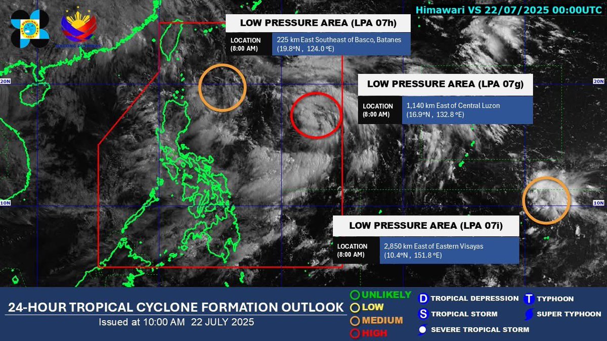
Low Pressure Area Update from @dost_pagasa as of 8 AM, July 22,
LPA 07g – Inside PAR, with high chance of becoming tropical depression within 24 hours; LPA 07h – Also inside PAR, with moderate chance of developing; LPA 07i – Outside PAR, also with moderate chance of developing.
Ayon kay DOE Asec. Mario Marasigan, maayos ang lagay ng power facilities at sapat ang supply ng kuryente sa kabila ng habagat. Nakatutok ang DOE sa distribusyon lalo na sa mga binaha.
Panoorin dito: https://t.co/fDg8dM0VcT
#BagongPilipinas#IntegratedStateMedia#ISM#Habagat
Heavy Rainfall Warning No. 39 #NCR_PRSD
Weather System: Southwest Monsoon (Habagat)
Issued at: 11:00 AM, 22 July 2025(Tuesday)
ORANGE WARNING LEVEL: Zambales, Bataan, Bulacan, Pampanga, Metro Manila, Cavite, Batangas and Rizal.
ASSOCIATED HAZARD: FLOODING is still THREATENING.
YELLOW WARNING LEVEL: Tarlac, Nueva Ecija and Laguna.
ASSOCIATED HAZARD: FLOODING in flood-prone areas.
Meanwhile, light to moderate with occasional heavy rains affecting Quezon which may persist within 3 hours.
The public and the Disaster Risk Reduction and Management Offices concerned are advised to MONITOR the weather condition and watch for the next warning to be issued at 2:00 PM today.
For more information and queries, please call telephone numbers 8927-1335 and 8927-2877 or log on to https://t.co/59mTpZJq1n.
TINGNAN: Patuloy ang isinasagawang rescue at evacuation operations ng City Disaster Risk Reduction and Management Office (CDRRMO) para sa mga residenteng apektado ng matinding pag-ulan sa Imus, Cavite.
📷: City Government of Imus
#IntegratedStateMedia#ISM#habagat