@BugateCate It could go both ways, can you imagine if after this storm pass and it led to chaos, the first thing that people will remember when they hear the storm's name is our VP. Or they could turn this into her getting revenge. Either way, Filipinos love superstitions and narratives
@BugateCate This is what's lingering on my mind as well I just thought I was the only one thinking about it. I don't want anything bad to happen on any person in the world but if somehow this storm devastates our country, 2028 election would be affected by it.
A LIFE THREATENING JUMPSCARE
First look at Cat 5 Super Typhoon Bavi on the Visible High Res of Himawari-9 satellite as it barrels through the Pacific Ocean during sunrise. It's expected to hit the Mariana Islands within 24-36 hours according to the latest JTWC forecast.
BREAKING NEWS: PAG-ASA upgrades Pre-#IndayPH / Bavi into a SUPER TYPHOON. This is still 3000 km away from the Philippines. It's moving westward at 20 kph and we can see a slight wobble to the westsouthwest. The first brunt of STY Bavi will be felt in Mariana Islands.
Dahil sa malakas na subtropical steering ridge o ang nagmamaneho sa mga weather systems katulad ni Bagyong Pre-#IndayPH / Bavi, kikilos ito pakanluran sa susunod na 36 oras ayon sa JTWC. Dahil dito, asahan din ang kaunting pagbaba ng mga tracks ng mga ahensya. Maghanda po tayo.
I-cocover po natin si Pre-#IndayPH / STS Bavi sa magiging kilos at bilis ng paglakas nito sa mga susunod na araw. Sa ngayon ay mataas ang tsansa na pumasok ito sa PAR habang mababa naman sa pagtama nito sa Mainland Luzon. Mag-antabay at mag-ingat po tayong lahat.
@adahbrown Watching MJ fly and stick his tongue out and make those one-hand fake passes will always be a bliss to watch. But in terms of dominance, I can't think of another player that could dominate the floor like LeBron. I think their skill set negate each other so pretty equal I guess.
@GayNathanX65807 The reason Metro Manila didn't receive the worst possible conditions is because of the sharp Northwest turn of Uwan before landfall. Also, nag-degrade yung structure niya possible due to its large size kaya hindi nagconsolidate. These were good news for people in Metro Manila.
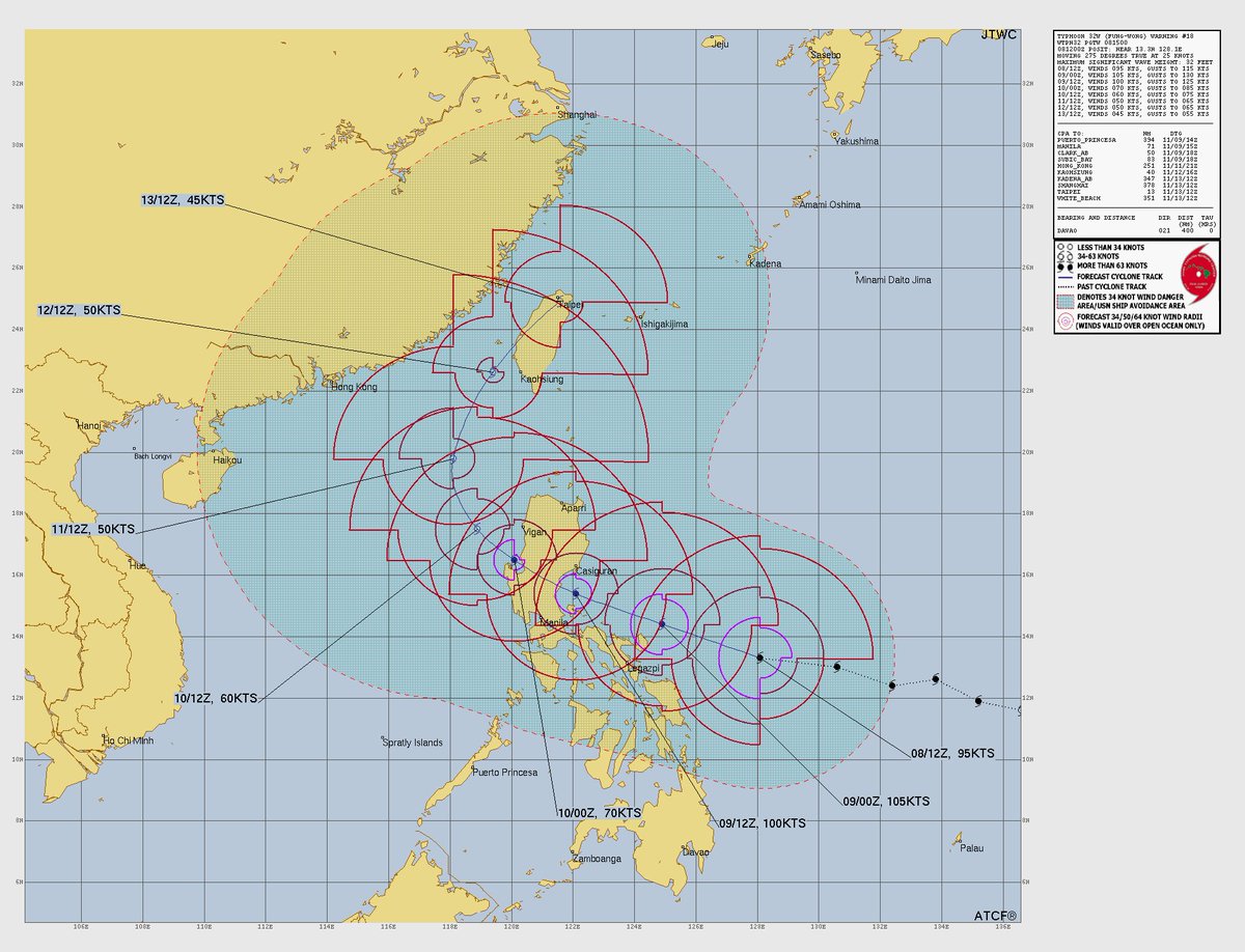
Bit of bad and good news for the Philippines. Typhoon #Fungwong#UwanPH is continuing to RAPIDLY intensify and deepen. According to the JTWC, it's now a 110 mph Cat 2 typhoon. Also, the track shifted slightly south, and now the 100 km/h wind radius is reaching to the NCR.
@GayNathanX65807 During the time of that post if you look at the forecast, nakikita mo po yung mga wind radius? Yung mga almost circle? 34, 50, 64 knot wind radius yan. Nakapasok ang Manila sa 50 knot or 100 km/h wind ng JTWC. Also Signal #3 of PAG-ASA translates to STS winds or 89-117 km/h.
We'll try to update as the conditions in our area continue to worsen but the latest JTWC update completely invalidates this as they upgraded Typhoon #Fungwong#UwanPH into a Cat 4 130 mph major typhoon.
Super Typhoon #Fungwong#UwanPH is on a WEAKENING trend given by ragged eyewall due to a bit of land interaction from the northern tip of Catanduanes. Also, it's battling off shear and it may be undergoing an eyewall replacement cycle. Nonetheless, this is still a major typhoon.
Latest PAG-ASA's estimate on Super Typhoon #Fungwong#UwanPH is still at 185 kph sustained with 230 kph gusts but recent satellite images and DVORAK analysis shows some weakening from this typhoon. However, this is still a large system that could bring heavy to torrential rains.
Super Typhoon #Fungwong#UwanPH is on a WEAKENING trend given by ragged eyewall due to a bit of land interaction from the northern tip of Catanduanes. Also, it's battling off shear and it may be undergoing an eyewall replacement cycle. Nonetheless, this is still a major typhoon.
PAG-ASA upgraded #Fungwong#UwanPH into a SUPER TYPHOON, and TCW Signal #5 is already issued in some parts of Bicol, including the fractures of Camarines Norte and Sur and Catanduanes and Polillo islands. It's the 2nd super typhoon that entered the PAR; the other was Nando.
Based on radar imagery from Windy, the ragged eyewall of Typhoon #Fungwong#UwanPH is already plowing through the Bicol Region. Expect the situation to deteriorate for the other places in Mainland Luzon, primarily Central Luzon starting from this morning.
@JonahNeil_X Isn't there a phrase "According to JTWC" in there? Unless my X glitches and I forgot to mention it then it's safe to say that the information came from the Joint Typhoon Warning Center. If you have no idea what it is here's the link to their website.
https://t.co/7HkzZql64K
@JonahNeil_X Then good for you. Again, what I'm posting here comes from agencies like JMA, JTWC, and PAG-ASA. Sometimes I also use NOAA for historical data. You can also use Windy, Cyclonicwx, and Tropical Tidbits for imageries and models. Stay safe out there!
I will start to wind down the updates starting from now as I also will get ready for the coming typhoon. I'll try to talk about some surface-level meteorology stuff and history soon and learn more in-depth terms and phenomena. Stay safe, everyone!
The last time NCR was placed under TCW Signal #4 was during Super Typhoon Goni/Rolly (2020) and Noru/Karding (2022, only northern part). These typhoons are miniscule compared to #UwanPH#Fungwong. There's a chance PAG-ASA will raise signal #4 to some Southern Luzon areas.
@ChipMonkSamuri@i_wagman Monitor the situation and call help if necessary. You can post or comment here on this thread if you're in a life threatening situation so we can help you call for rescuers. Ingat!
BREAKING NEWS: PAG-ASA upgrades Typhoon #Fungwong#UwanPH to 175 kph with gusts pushing to 215 kph. Note that it's moving very fast at 35 kph so landfall or close approach to Catanduanes and Bicol might be earlier than anticipated. Just 10 kph shy of Super Typhoon.