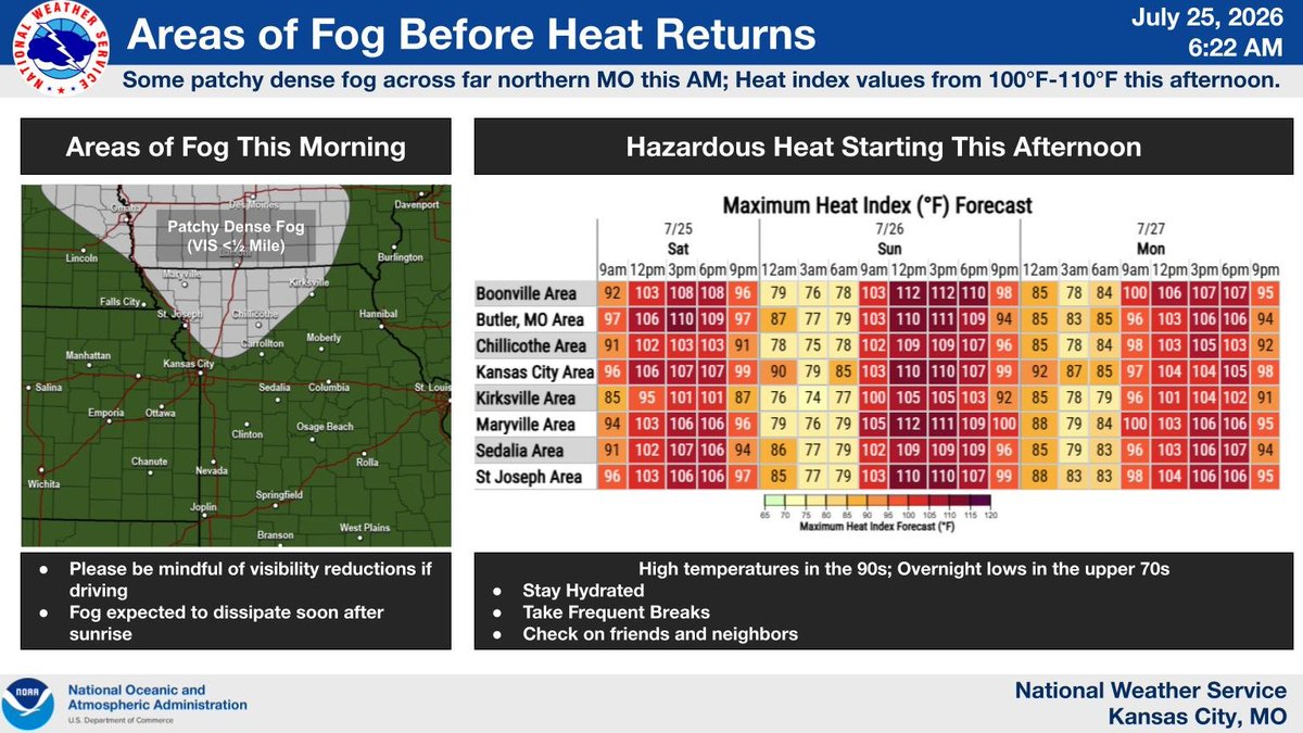
Some patchy areas of dense fog this AM across northern MO. Please be mindful if traveling. Fog evaporates after sunrise as temps heat up. Highs in the 90s with dew points in the upper 70 yield heat index values from 100°F - 110°F. Hazardous heat continues Sun & Mon.
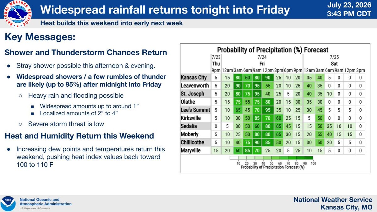
Showers & t-storms envelope the area this morning. Some flooding is possible as pockets of heavy rainfall are expected. Please be cautious when traveling reduced visibility & potential for hydroplaning. After rain exits this evening hazardous heat returns this weekend.
More widespread opportunities overspread the area tonight into Friday. This includes widespread amounts up to around an inch and localized amounts of 2 to 4 inches possible. This too results in the potential for flash flooding.
😎 Pleasant conditions generally continue today
🌧️ Chances for showers and a few rumbles of thunder return today and especially overnight into Friday
🥵 Heat and humidity build back into the area this weekend, generally peaking Sunday and Monday.
Smoke from wildfires in the Pacific Northwest will linger across the area for a few days, but cooler and less humid conditions expected over the next several days. Storm chances return later this week with heavy rain and flooding possible.
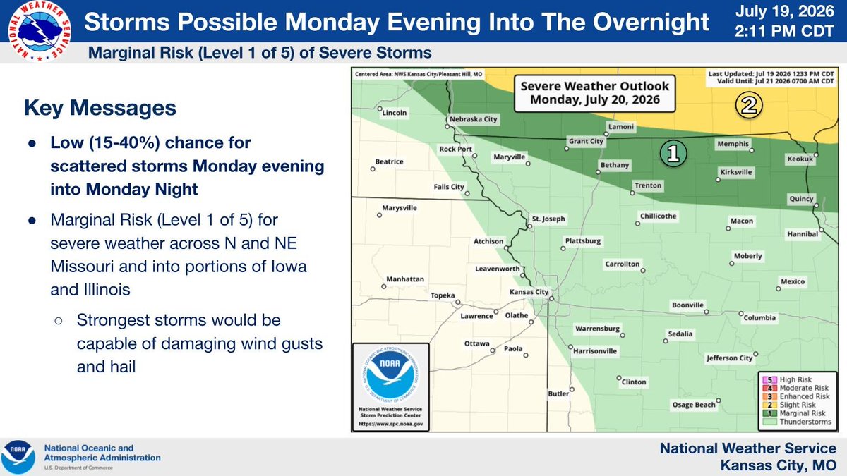
Storms are expected to move into northern and northeastern Missouri tonight into tomorrow morning. The best chances tend to be after midnight and through the overnight hours. The strongest storms may be capable of strong to damaging winds and hail. #mowx#kswx
A Heat Advisory is in effect today, with temperatures in the mid-upper 90s and heat indices of 105-110. Storms are possible tonight across northern MO. The Heat Advisory continues tomorrow for areas south of I-70. Relief from the heat and humidity arrives by mid-week. #mowx#kswx
EMERGENCY: A rare, catastrophic Flash Flood Emergency is active for Beaver County, UT. A massive debris flow from the Cottonwood burn scar has reportedly overtopped a diversion dam and is rushing down the Beaver River. If in Beaver City, UT, seek higher ground immediately!
🥵 Hot and humid today ... heat advisory across the area.
🌡️ Some heat lingers south of the KC area Tuesday.
⛈️ Storm chances tonight / overnight, mainly for N and NE Missouri
😎 Relief from heat and humidity by mid-week
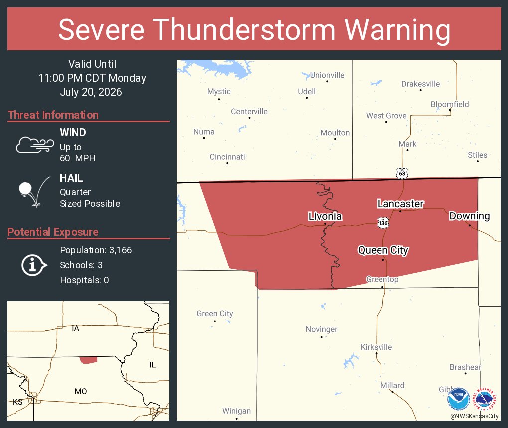
There is a low (15-40%) chance for scattered storms Monday evening into Monday night. The strongest storms may be capable of damaging wind gusts and hail. #mowx#kswx
Heat and humidity continue through Tuesday. A Heat Advisory is in effect for all of northern MO on Monday and areas south of I-70 on Tuesday. Scattered showers/storms this afternoon along and south of US-36. Locally heavy rainfall and gusty winds are possible. #mowx#kswx
🥵Heat continues today, peaks Monday with a Heat Advisory
⛈️Scattered showers and thunderstorms possible again today, especially near and south of Highway 36
Afternoon and evening storms are possible the next few days, which may be capable of producing gusty winds or locally heavy rainfall. Heat is expected to continue to build into Monday, with heat indices 105 to 110 F possible.
A few storms again possible today, with similar potential for heavy rainfall and gusty winds ... though most will be dry.
Heat and humidity continue to gradually build, looking to peak on Monday. Then some relief by the middle of next week.
Isolated to scattered thunderstorms are forecast between 1 and 7 PM today, with the best chances south of I-70. While severe thunderstorms are not expected, the storms could produce brief gusty winds and heavy rainfall. Heat and humidity will peak this weekend and Monday.
EMERGENCY: A confirmed tornado is on the ground and tracking north near San Antonio, TX. The storm is moving directly toward Fair Oaks Ranch, TX and Bulverde, TX. Take shelter in an interior room on the lowest floor immediately! Source: National Weather Service.