FLORIDA COASTAL FLOODING POTENTIAL UPDATE… As expected, Coastal Flood Warnings are now up along the east coast of Florida from Jupiter Inlet north. Also, Gale Warnings are in effect for the same areas. Coastal Flood Advisories are in effect south of Jupiter Inlet to the Keys. Large breaking waves are anticipated, along with moderate to severe beach erosion, gusty winds, and higher than normal tides on top of the king tides, particularly in the warning areas.
Beachgoers are strongly discouraged from entering the surf for the next several days due to the threat of dangerous breaking waves and rip currents. Boaters are encouraged to refrain from venturing offshore, and exercise extreme caution on inland lakes and waterways.
Low-lying areas along the coast could experience inundation from a combination of the king tides, the push of water onshore due to strong NE winds and large waves. Some roads along the coast could become impassable due to these conditions
This is a long duration event. Winds and seas will remain elevated for the next several days
COASTAL FLOODING/HIGH SURF UPDATE… As of 8am this morning, 10/23/26, Coastal Flood Advisories are in effect for the ENTIRE east coast of Florida from the St. Mary’s River to the Middle Keys. A Coastal Flood Watch is in effect for northeast and east-central Florida. The Coastal Flood Watch for northeast FL goes into effect tonight and goes through Monday night. For east-central Florida, the Coastal Flood Watch is in effect from late Saturday night through late Sunday night. Coastal flooding and moderate to major beach erosion can be expected this weekend, especially around the time of high tide. And add to that, the king tide cycle, featuring the highest astronomical tides of the year, will be upon us for the next week as these conditions will also be of long duration. This will increase the risks/potential impacts to the coastal zones.
Residents and visitors are strongly advised to stay out of the extremely dangerous surf this weekend. Offshore boating is strongly discouraged as well, as there are Gale Watches in effect for the northeast and east-central coasts. Dangerous seas, possibly as high as 20 feet, are expected.
Caution is advised on area lakes and waterways due to strong winds making for very choppy conditions. If recreational boating on inland waters, make sure to use personal floatation devices.
Elsewhere across Florida, it will be a breezy to windy weekend. Rain will be most likely along the east coast, with the highest potential for heavy rain across southeast FL. High temps this weekend will be in the 70s and 80s statewide, with lows ranging from the upper 40s/50s Panhandle, to 70s southeast and Keys. #FLwx
WINDY WEATHER AHEAD. Not much change to the forecast philosophy for the upcoming weekend and into next work week as we will see a tight pressure gradient set up across the state. This will lead to very windy conditions, especially along the east coast… along with hazardous seas, rough surf, and the possibility of coastal flooding and moderate to major beach erosion over an extended period of time.
Of course, all of this is happening on top of the highest tides of the year, king tides. Areas prone to coastal flooding in king tides will be especially prone given the long fetch of NE winds piling up water and surf.
Adding insult to injury is current forecast models call for locally heavy rain primarily along the southeast coast especially as we head through the weekend. Precip totals of 2-4” (locally higher amounts possible) on top of saturated grounds and coastal flooding prone areas will make for a heightened concern for inundation in areas.
CERA modeling from this morning (pictured below) shows the potential for water levels to be 6-7 feet above MSL (mean sea level) for the date, particularly in NE FL and Georgia where the continental shelf is much broader allowing water to pile up easier. This equates roughly to 1-3 feet above the predicted tide levels. This will not be a gloom and doom type situation or historic event by any stretch, however we will likely see issues with coastal flooding in these areas. Farther south (south of Cape Canaveral to South Florida), water level rises up to a foot above the projected king tide levels are possible. These levels will produce concerns for coastal flooding and moderate-major beach erosion, considering this will be a long duration event.
Currently, forecast models show sustained winds 25-35mph along the coast, with gusts 40-45 possible. Offshore sea heights are forecasted up to 20 feet possible with gale force gusts expected. We can expect to see Gale Warnings, likely Wind Advisories, along with Coastal Flooding headlines across many areas of the coast
We will keep you advised of any watches and warnings issued #FLwx
…WATCHING FOR STRONG WINDS, HAZARDOUS OCEAN CONDITIONS AND BEACH EROSION, THIS WEEKEND…
Current forecasts indicate gradient winds of 30kt and gusts to 40kt possible over the Atlantic coastal waters for this upcoming weekend and the start of the next work week. Along with hazardous seas, dangerous boating and surf conditions. There is also the potential of moderate to major beach erosion and possible coastal flooding with the king tides returning this weekend.
Will provide more detailed breakdown Thursday. #FLwx
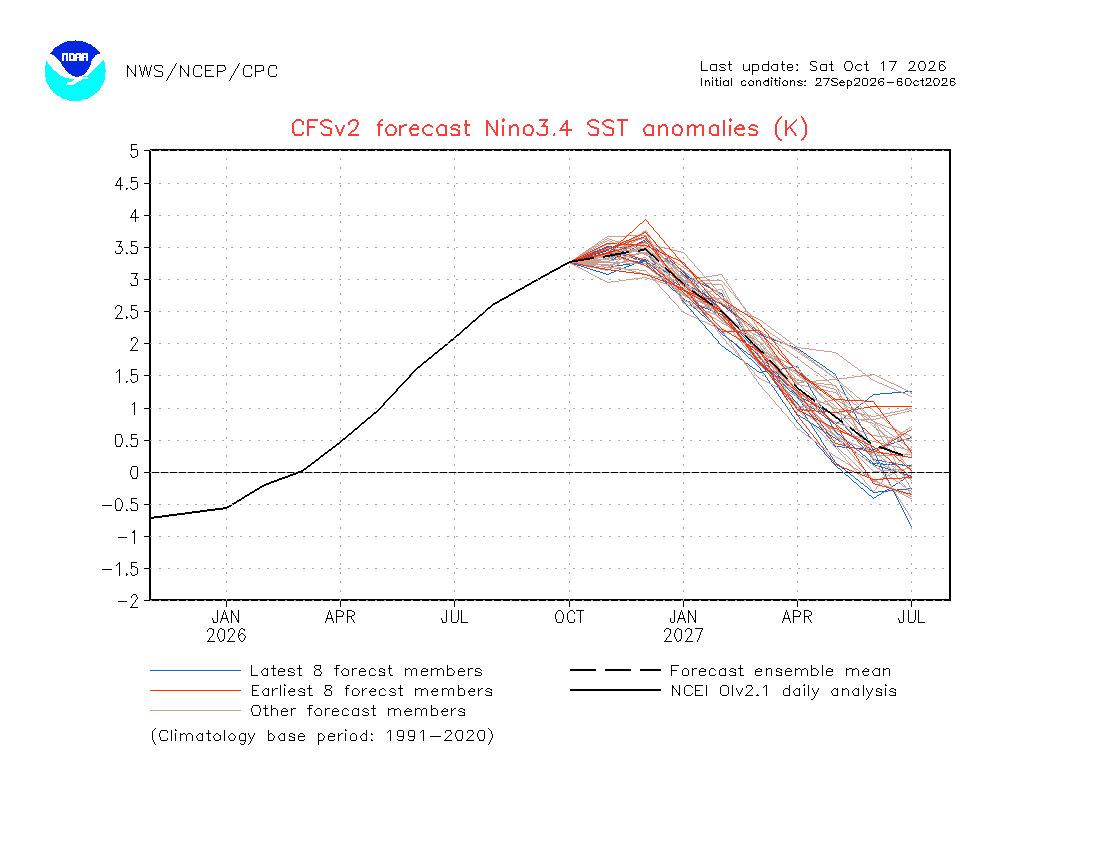
As we enter late fall and approach winter, it's important to highlight the potential for increased severe weather activity across the Southeast, particularly Florida, as a historically strong El Niño continues to develop.
When analyzing previous strong El Niños: 1965-66, 1982-83, 1997-98, 2015-16, 2023-24, all of those years featured F2/EF2+ tornadoes across all of Florida.
#flwx
🚩 🚩 GALE WARNING ⚠️ 🚩 🚩 Gale Warnings are in effect for the northern half of the waters surrounding Florida this morning as a strong front moves though. Elevated winds and seas are anticipated, with wind gusts up to 40kts and seas up to 18 feet.
Over land, windy conditions are expected with winds 20-30mph and gusts to 40-45mph, especially along the coast. Entering the surf zone is highly discouraged due to large breaking waves and strong rip currents.
There is a slight risk for excessive rainfall, as outlined by the @NWSWPC for southeastern Florida, where band is rain, heavy at times, may impact areas near and just inland from the coast, mainly from Fort Pierce south. Do not drive on flood covered roads. For your safety, “Turn around. Don’t drown.”
Hazardous boating and beach conditions will persist through the upcoming week with strong winds and large waves. And it will remain breezy to windy over land areas, as well.
Temperatures through the next 7 days will remain in the 70s north and 80s south. Lows in the 40s in interior parts of the Panhandle to 70s south coast and Keys
10/15/26:
We have confirmed an EF-0 tornado with 75 mph winds just east of Eastpoint, FL on October 9th, 2026 around 5:45 pm EDT. This was from an outer band of Hurricane Isaias.
The Public Information Statement about it can be found here: https://t.co/lUS8VJ9juZ
#flwx
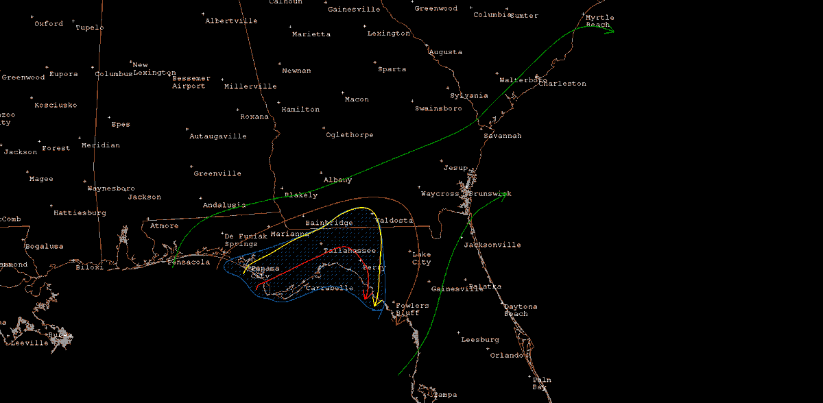
Beginning with the 12Z runs of the Euro on 10/15, a notable change in the evolution of the pattern across the southwestern Atlantic began to take shape. Now there appears to be a growing consensus in the models (deterministic and the ensemble means) of a low pressure taking shape somewhere in the SW Atlantic. What is not known at this point is exactly where, and this will have implications in our weather forecast here in Florida over the next 7 days. So let’s try to unpack this thing based on the current data available (based on the 00Z models). First up is a look at the 850mb differences between the GFS and Euro Ensemble means. The GFS ensemble mean does not like to close off a low pressure off the SE US coast, instead, after the frontal passage, it builds and maintains a consistent ridge in place… whereas the Euro (which has increasing model support) wants to develop a closed low off the NC coast #FLwx
As mentioned, with either solution… it will be windy across the state! Because of each model’s handling of the low pressure, there are differences in how much wind there will be. The Euro is closer to us, therefore the gradient will be tighter, therefore windier. With that, it also increases significant wave heights to 15 feet or higher across the waters. GFS keeps a weaker, albeit still tight, gradient across the region, and in turn keeps seas a little lower, but still very elevated. Regardless of which solution, dangerous boating conditions and rough surf will be an issue from this weekend and well into next work week. Winds at times could reach to or exceed 30kt, and gusts to gale force. Beach erosion and coastal flooding concerns around the time of the high tide cycles also. All of this said, severe weather is currently not anticipated for the next 7 days. We will keep you updated #FLwx
Because of the difference in locations of the lows, it makes a difference on how cool temps get and for how long. As shown above… the Euro keeps the low in a stagnant pattern, keeping cooler air flowing south for much longer than the GFS. In fact cooler temps could be the theme for the entirety of the next work week, should the Euro be correct. The GFS keeps a progressive pattern in place, with cooling limited mostly to the northern 1/3 of the state and for a very limited duration. #Flwx
10/15/26:
We have confirmed an EF-0 tornado with 75 mph winds just east of Eastpoint, FL on October 9th, 2026 around 5:45 pm EDT. This was from an outer band of Hurricane Isaias.
The Public Information Statement about it can be found here: https://t.co/lUS8VJ9juZ
#flwx
Here is a look at the QPF (Quantitative Precipitation Forecast) over the next 7 days and also a Day 5 “Marginal” risk of excessive rainfall. Courtesy: @NWSWPC#FLwx
The models are in excellent agreement on the next cold front moving into/through the Sunshine State late week and into the weekend. Behind this boundary, models are forecasting very gusty winds… especially along the coast. An extended period of strong winds is currently forecasted. A long fetch of N/NE/E winds is anticipated, and with this large ocean waves will impact areas along the east coast starting Saturday and lasting well into the next work week. Seas could approach 13-15 feet at times, especially in the Gulf Stream. This will produce dangerous ocean conditions and venturing into the surf or partaking in any offshore boating activities is not advised. Winds are currently forecast to reach 30kts with frequent gusts to gale force (greater than 34kt). Large breaking waves will produce a high risk for dangerous rip currents. Also, beach erosion looks very likely during the high tide cycles through at least Monday.
There will also be an increased risk of showers along the east coast, especially. Models have wide-ranging totals along the coast, as well as various solutions as to the areas most impacted. Tuesday, @NWSMelbourne highlighted the potential for locally heavy/excessive rainfall as we head through the weekend, especially along the coast. Again, it’s too early to speculate which areas along the coast will see maximized amounts, just to note that heavy rainfall is possible, which could lead to the potential for flooding, especially in areas that have seen heavy rainfall of late. Severe weather is NOT anticipated. We will keep you updated. #FLwx (Below are some of the Euro, EuroAI, GFS, GFS AI solutions regarding the wind)
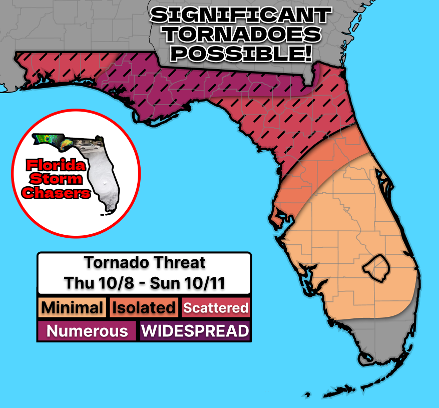
There it is! We now have a tornado report near Eastpoint, FL, associated with the outer bands of Hurricane Isaias. This report falls directly within our previously issued 15% tornado risk area. Data is still preliminary, and no survey is out just yet but @NWSTallahassee mentioned a statement could be out as soon as tomorrow morning!
#flwx #hurricaneisaias
...Hurricane Isaias (2026) Post Synoptic Analysis...
Recently, we've been seeing some posts regarding the lack of tornadoes that Florida experienced in accordance with the outer rain bands of Hurricane Isaias. This post is to explain what fail measures were in place and how our tornado probabilities verified!
(1/9)
#flwx #hurricaneisaias #tornado
On the morning of November 9, 2026, multiple sources issued their own tornado guidance regarding the threat of a few tornadoes.
Forecast guidance suggested an increasingly favorable environment for tornadic supercells, particularly near the Gulf Coast, where strengthening low-level wind shear and tropical moisture were expected to support rotating thunderstorms
However, considerable uncertainty remained regarding the northward progression of the warm front, the extent of inland destabilization, and whether the most favorable tornadic environment would reach the coastline.
(2/9)