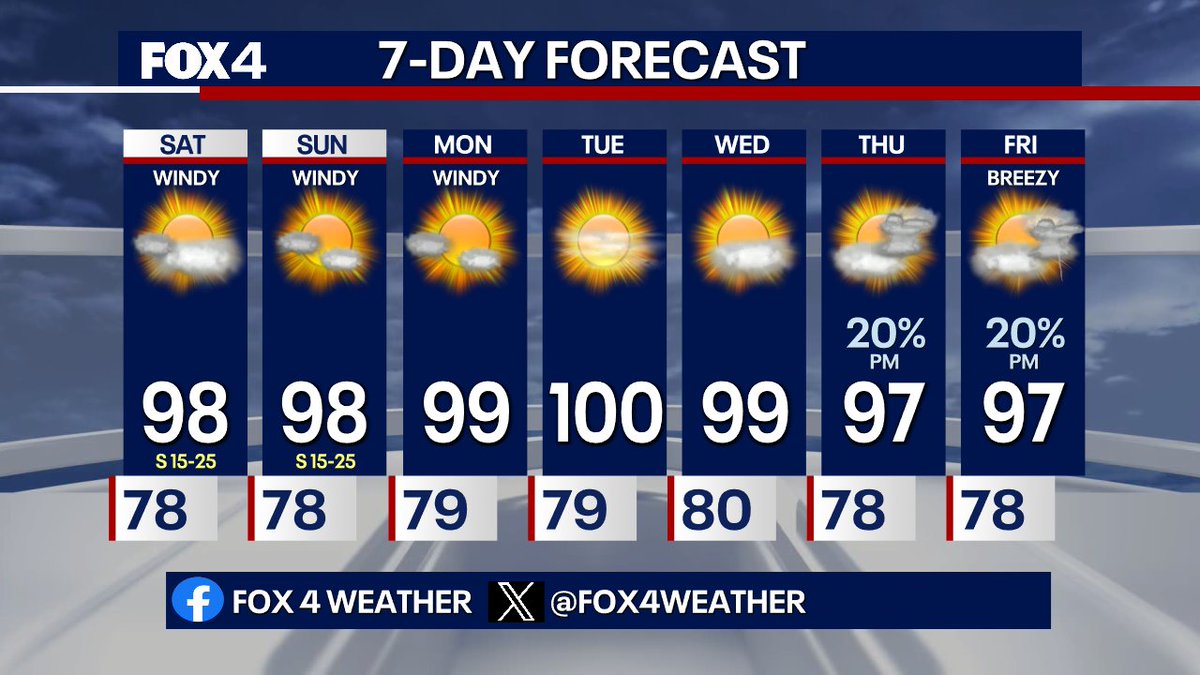
7 DAY FORECAST: Rinse and repeat for Sunday! Highs make it to the upper 90s despite some morning clouds, and the wind will still be around. Some Saharan dust moves in Monday and Tuesday, with temps near 100 all week. By the 4th, some small storm chances will arrive. #TXwx
It could be worse... On this day in 1980, DFW recorded its hottest temperature EVER when the mercury jumped to 113°! Today's temps will run about 20° cooler, with afternoon highs settling in the upper-90s.
Tropics Update: An area of low pressure is expected to form off the southeastern coast of the U.S. early next week. The National Hurricane Center has tagged it with a 20% chance for tropical development in the next 7 days.
7 DAY FORECAST: Big heat builds into the weekend as highs reach about as close as possible to 100 in the afternoon! Feel like numbers will be near 105 during the peak heat of the day, so stay hydrated! By the end of next week, some small storm chances could arrive. #TXwx
A warm and windy evening continues across North Texas as temperatures likely won't fall out of the 90s until 10pm or later! Winds will hang around at 15-25mph through the evening. However, no issues for any plans! #TXwx
A ridge of high pressure builds & settles to our east this weekend. This dries us out and warms us into the upper 90s to 100 degrees into next week. Today, one last piece of energy keeps a low rain chance in place, especially this morning. South winds bring Saharan dust Monday.
A few isolated showers may graze our Red River counties overnight/Friday, otherwise temps will inch upward over the next several days as a ridge of high pressure builds. Dry weather for much of N TX through Wednesday before we see a slight chance of storms return Thursday,
10:26pm: Monitoring strong to severe storms in West Texas and arcing northeast into Central OK. While we don't expect any severe weather in N TX, a few of these showers/storms may graze our Red River counties overnight.
(4PM) a few showers have popped up over Ellis county and also to the east of Lake Tawakoni. A weak disturbance lifting over has brought a bank of clouds and just enough lift to pop them off. That's pulling to the southeast, so no issues for the #JAPvsSWE#FIFAWorldCup match!