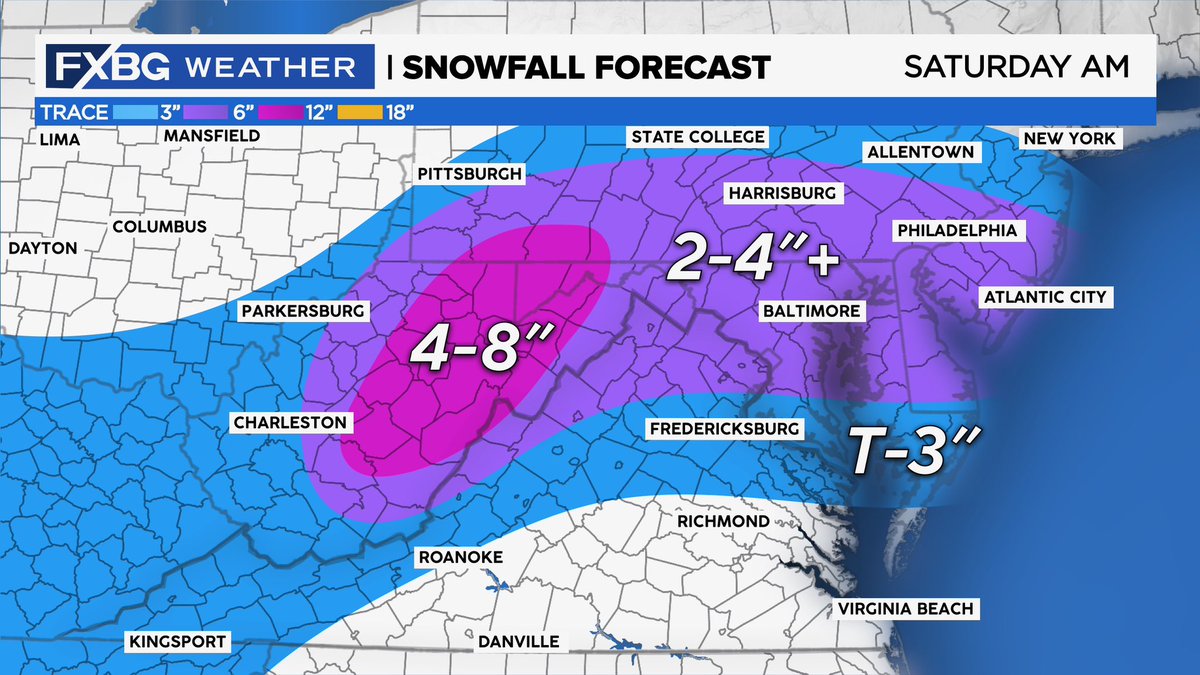
Modeling has continued to weaken this clipper system and push what moisture there is with the storm further north into MD and PA. So, snowfall totals will likely range on the low-end of those forecasted for many in our coverage area. #FXBGWeather
SNOWFALL FORECAST | rain and snow should start after midnight, changing to all snow by 2am. Areas north and west of Stafford have the best shot at seeing accumulating snowfall. Areas south of Stafford will see much less with only a Trace -1" likely.
TONIGHT | a mix of rain and snow around midnight, changing to all snow after 2am. A few hours of heavier snow is possible with more snow north and west. The plowable snow will be mostly north and west of Stafford county, much less snow south and east.
This would keep snow accumulation in the Burg on the LOW end of our map. Considering the trends this afternoon, we continue to expect plowable snow north of Stafford, but areas south of Stafford could see snowfall on the lower end.
FUTURE RADAR | here's a look at the latest GFS model showing the snow moving in overnight. Many models this evening have gone ahead and shifted the storm northward a bit. Should these be accurate, that would bring the rain/snow line much closer to the Fredericksburg area!
SNOWFALL FORECAST | we’ve updated our numbers a bit in our latest forecast. We expect a general 1-3” of snow across the region. Expect less snow south of Fredericksburg and more snow north of Fredericksburg.
In areas from Fredericksburg northward, we could see periods of HEAVY snow with some heavier bands setting up. Dynamics also lend themselves to the potential for even some thunder snow! ⚡️ Where bands set up, an additional 1-3” of snow could fall on top of these totals.
WEATHER HEADLINES | cloudy today, but snow moves in overnight. The snow could be heavy at times with a few inches of accumulation possible. More snow north and west. We’ll have an updated snowfall map out around midday with a few changes and updates!
SNOWFALL FORECAST | a clipper system will bring a period of widespread snow to the region Friday night and Saturday morning. A few inches of snow can be expected across the area with isolated 4"+ amounts possible, especially along the ridges. #FXBGWeather
We also expect the NWS to issue Winter Weather Advisories later today as well. Plan on potential impacts to weekend plans Friday night and Saturday. #FXBGWeather
𝐖𝐈𝐍𝐓𝐄𝐑 𝐒𝐓𝐎𝐑𝐌 𝐑𝐈𝐒𝐊 | we're turning up our winter storm meter to "𝐋𝐈𝐊𝐄𝐋𝐘" for Friday night and Saturday morning. A period of accumulating snow looks likely across our region. We'll have our snow map out later this afternoon.
THE NEXT 7 DAYS | we're continuing to keep our eyes on the potential for a period of light SNOW Friday night into Saturday morning from a clipper system that will move through the region. Generally, snowfall will be light, but a few locations may pick up a few inches of snow!
SNOW POTENTIAL | models continue to show the potential for a clipper system to bring a period of LIGHT snow to the region Friday night and Saturday morning. We’ll continue to track this system as we head into the weekend. #FXBGWeather
If that verifies, the potential for a light snow event exists Friday night into Saturday morning. We’ll continue to monitor guidance and refine this forecast - but for now - plan for the potential for a little light snow with possibly minor accumulations possible Friday night.
POTENTIAL LIGHT SNOW EVENT | a clipper system is forecasted to move through the area Friday night and models have been indicating that, while most clipper systems are moisture-starved, this one might end up being a little more robust. ❄️❄️❄️
THE NEXT 7 DAYS | tranquil weather with above-average temperatures for the next few days but then our eyes turn to the weekend which will bring an injection of colder air and the chance for some snow, too! ❄️ We'll have more details on the snow chances tomorrow!
All Fauquier County Public Schools will be closed Tuesday, February 13. Administrative offices will open at 12 p.m., and essential personnel should report at 11 a.m.