Flood Watch for Claiborne, Hancock, Hawkins & Others until 9:00 PM Mon. Flash flooding possible from heavy rain (1-3 in/hr). Watch creeks/low spots; move to higher ground if flooding starts.
Special Weather Statement for Avery, Madison, Yancey, Mitchell, Swain, Haywood, Buncombe & Others this morning. Dense fog may reduce vis suddenly over short distances. Use extra caution on I-26 and I-40. Slow down, increase distance, use low-beam headlights.
Dense Fog Advisory for Ashe, Alleghany, Smyth & Others until 9 AM EDT. Vis 1/4 mi or less in dense fog. Use low beams, slow down, allow extra time; use caution when driving.
Special Weather Statement for Ashe & Others tonight. Dense fog may quickly reduce vis to near zero, making driving difficult. Leave extra time, slow down in fog, and keep a longer distance between cars.
Special Weather Statement for Northwest Cocke, Cocke Smoky Mountains, Northwest Greene, Southeast Greene until 7:00 PM 6/2. Wind gusts up to 40 mph and 0.5 in hail possible. Radar-indicated storm. If outdoors, seek shelter indoors.
Special Weather Statement for Northwest Greene, Southeast Greene, Washington, and Unicoi until 6:30 PM 6/2. Wind gusts up to 50 mph and nickel-size hail possible. Radar-indicated storm. If outdoors, seek shelter inside a building.
Special Weather Statement for Alleghany, Surry, Smyth, Bland, Wythe, Pulaski, Grayson, Carroll, Floyd, Patrick & Others until 6:00 PM EDT. Wind gusts up to 40 mph. Strong storms may bring brief heavy rain/low visibility. Seek shelter indoors; slow down.
Special Weather Statement for Northwest Greene, Southeast Greene, Washington, and Unicoi until 5:45 PM 6/2. Wind gusts up to 50 mph and 0.5 in hail possible. Radar-indicated storm. If outdoors, seek shelter inside a building.
Special Weather Statement for Smyth, Wythe, Pulaski, Montgomery, Grayson, Carroll, Floyd, Patrick until 5:30 PM 6/2. Wind gusts up to 40 mph may knock down tree limbs and blow unsecured objects. If outdoors, seek shelter inside.
Special Weather Statement for Wise, Scott, Russell, Washington until 5:30 PM 6/2. Wind gusts up to 50 mph and 0.5 in hail possible. Radar-indicated storm may knock down tree limbs and blow unsecured items. Seek shelter indoors if outdoors.
Special Weather Statement for Tazewell, Smyth, Bland until 4:15 PM 6/2. Pea-size hail and wind gusts up to 30 mph possible. Locally heavy rain may cause reduced vis and ponding/standing water. Seek shelter indoors; slow down.
Special Weather Statement for Sullivan, Washington, NW Carter until 4:15 PM 6/2. Wind gusts up to 40 mph and penny-size hail possible. Gusty winds may knock down limbs and blow unsecured objects. If outdoors, seek shelter inside.
Special Weather Statement for Hawkins, Sullivan, Scott until 4:15 PM 6/2. Wind gusts up to 40 mph and pea-size hail possible. Radar indicated. Gusty winds may knock down limbs and blow unsecured items. If outdoors, seek shelter indoors.
Special Weather Statement for Sullivan, Scott, Russell, Washington until 4:15 PM 6/2. Pea-size hail possible with a strong thunderstorm. Minor hail damage to vegetation. If outdoors, seek shelter inside a building.
Flood Advisory for Greene, TN until 7:15 PM 6/1. Urban & small stream flooding from heavy rain is expected. Minor flooding in low-lying areas; rises in small streams. Turn around, don’t drown—avoid flooded roads.
Special Weather Statement for Whitley, Knox, Bell until 6:45 PM 5/31. Wind gusts up to 40 mph and pea-size hail possible. Gusty winds may knock down limbs; localized flooding possible. If outdoors, seek shelter; don’t drive through flooded roads.
Special Weather Statement for Whitley, Knox, Bell until 5:30 PM 5/31. Wind gusts up to 40 mph and pea-size hail possible. Torrential rain may cause localized flooding. Seek shelter indoors; don’t drive through flooded roads.
Flood Advisory for Bell, KY, Knox, KY & Whitley, KY until 12:15 PM ET. Flooding from excessive rainfall is expected. Minor flooding in low-lying/poor drainage areas. Turn around, don’t drown—avoid flooded roads.
Flash Flood Warning continues for Greene, TN until 10:00 AM EDT. Flash flooding from thunderstorms is ongoing; roads/underpasses may be flooded and impassable. Turn around, don’t drown—avoid flooded roads and low areas.
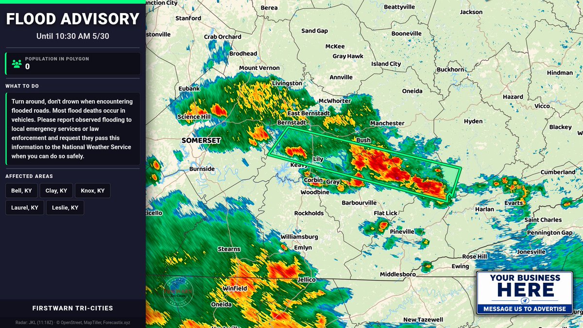
Flood Advisory for Bell, KY & Others until 10:30 AM EDT. Flooding from excessive rainfall is possible. Minor flooding may occur in low-lying/poor drainage areas. Turn around, don’t drown—avoid flooded roads.