Cloud Watcher / Wx Forecaster / Wind Enjoyer / Turbo Introvert
Simply here to lurk & learn on this peculiar place called WxTwitter
On hiatus from posting :)
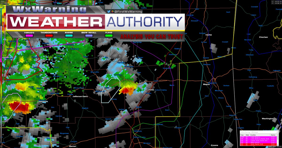
Rapidly exploding echo tops over the past 15 minutes to now slightly >40kft shows intense updraft development which can be a precursor to tornadogenesis, If you live in Hot Coffee, Taylorsville, or Summerland, stay on high alert! #tornado#severewx#severeweather#wx#mswx
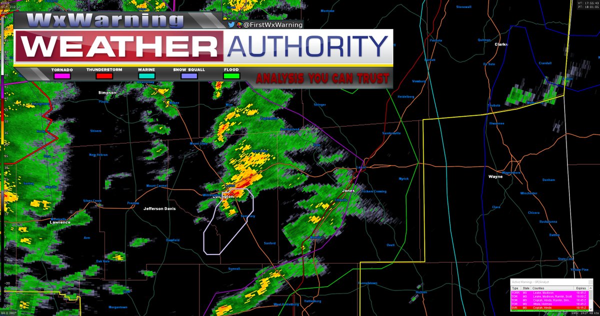
Keep an eye out for this storm in the open warm sector in Covington county #Mississipi out ahead of the main squall line. It appears to be developing its low level mesocyclone rapidly and could be producing a #tornado shortly #severewx#severeweather#wx#mswx
Keep an eye out for this storm in the open warm sector in Covington county #Mississipi out ahead of the main squall line. It appears to be developing its low level mesocyclone rapidly and could be producing a #tornado shortly #severewx#severeweather#wx#mswx
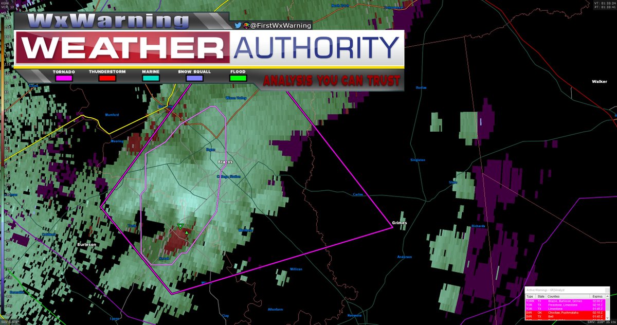
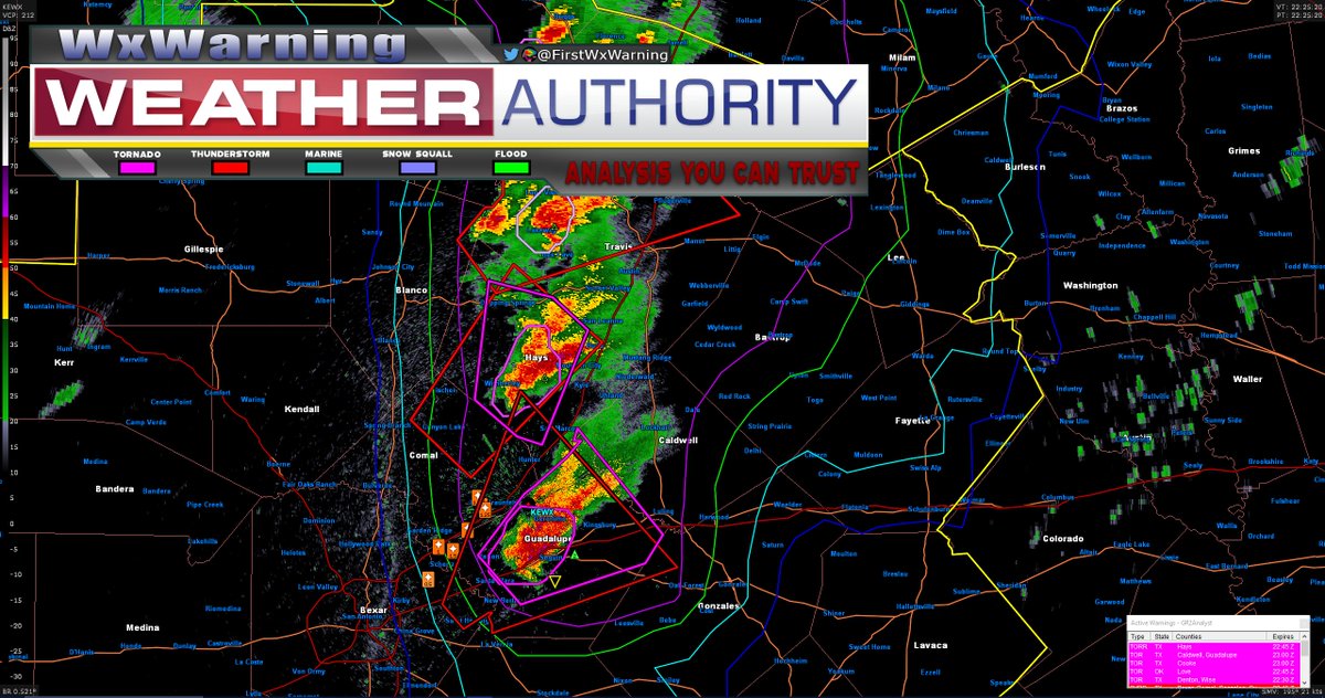
EM has just now confirmed a #tornado on the ground a couple miles to the SW of College Station #Texas The volatile atmosphere is still in place from earlier so there is no reason you shouldn't be in your tornado shelters now #severewx#severeweather#txwx#wx
Some of the dry line initiation has finally gone #tornado warned as these supercells have started moving into the highly sheared environment across central #Texas I wouldn't be surprised if more tornado warnings begin to pop up in the near future #severewx#severeweather#txwx
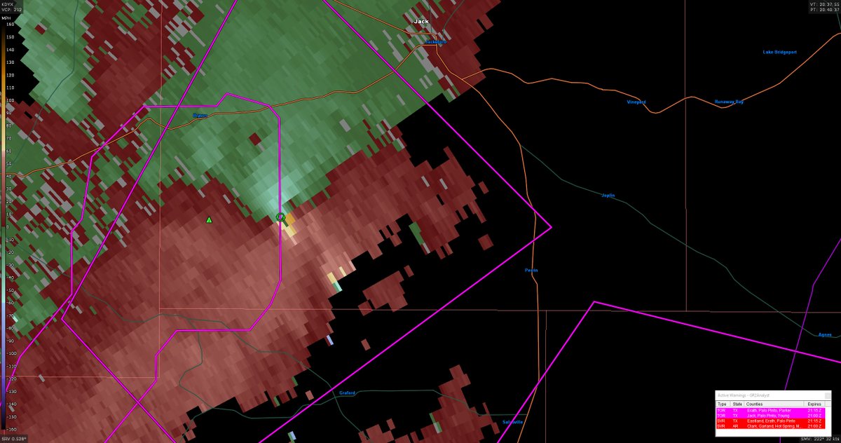
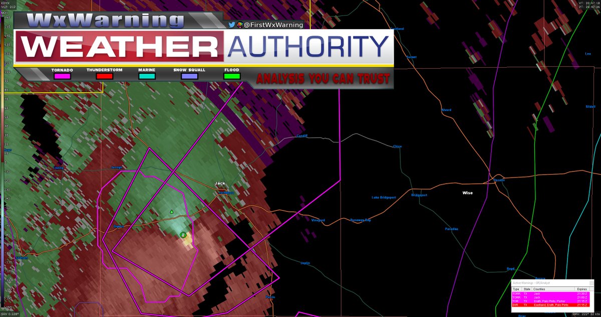
GTG velocity is now at ~135mph which is indicative of a strong tornado which is currently confirmed as still on the ground. Jacksboro you now have less than 15 minutes to finish heading to your basement or most interior room #tornado#severewx#severeweather#wx#txwx
Strong couplet w/ a possible #tornado on the ground heading towards Jacksboro #Texas Even though you are not directly in the warning polygon, you will likely start wanting to prepare your tornado precautions now #severewx#severeweather#wx#txwx
@Oakhurst_Wx Very well though out discussion!I 100% agree that many people are over looking the deep layer shear aspect of this setup Im thinking central Texas late afternoon/early evening transitioning to NE Texas closer to dynamic support as destabilization wanes have best tornado potential
[4/4] All this considered, I think if you translate the box that I outlined a bit to the S, you will end up with a pretty accurate assessment of what tomorrow's #tornado threat will likely look like
[1/4] Analogs for tomorrows severe weather setup seem to favor N #Texas for the greatest #tornado threat. I generally agree with the percentage probabilities, however it does appear to be slightly displaced too far to the N. This is likely due...#severewx#severeweather#txwx#wx
[3/4] This difference also manifests itself when looking at the SigTor parameter comparing both the analog mean (black contours) and NAM (red contours) You can see the nose of the Sig #Tornado probability is much closer to the Red River than what the current CAM guidance suggests
[3/3] Large hail will likely also be a threat with the initial supercells with cold temperatures aloft steepening the lapse rates along with around 80kts of deep layer shear. This could be supportive of cells with 2in or greater hail in conjunction with the tornadic threat.
[2/3] Near storm soundings do favor rapid upscale growth and cell splits which could be an inhibiting factor but a pronounced mid level EML should at least allow semi discrete development for several hours before the prevailing threat transitions to damaging winds across E Texas
Latest SREF is forecasting a stronger frontogenetic forcing band to lift through central SNE around lunch time This could bring some parts of the interior into the 2-3in range as opposed to earlier runs which kept the strongest forcing closer to the the coast #mawx#riwx#ctwx
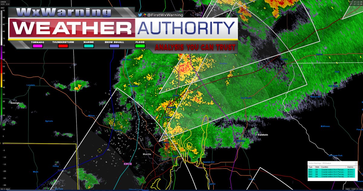
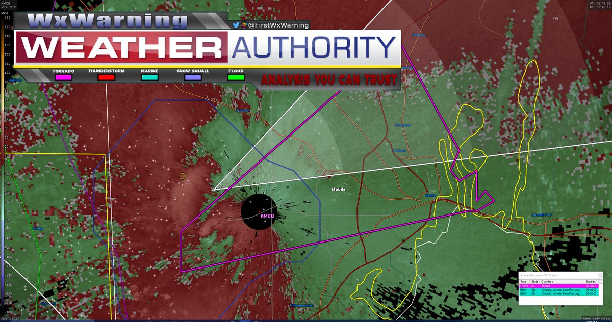
The #tornado warning for Mobile #Alabama has been CANCELLED as the tornado has now lifted. All tornadic indicators for this cell continue to downtrend. A cycle could happen and it looks like it briefly tried but I don't believe its very likely at this point #severewx#alwx#wx
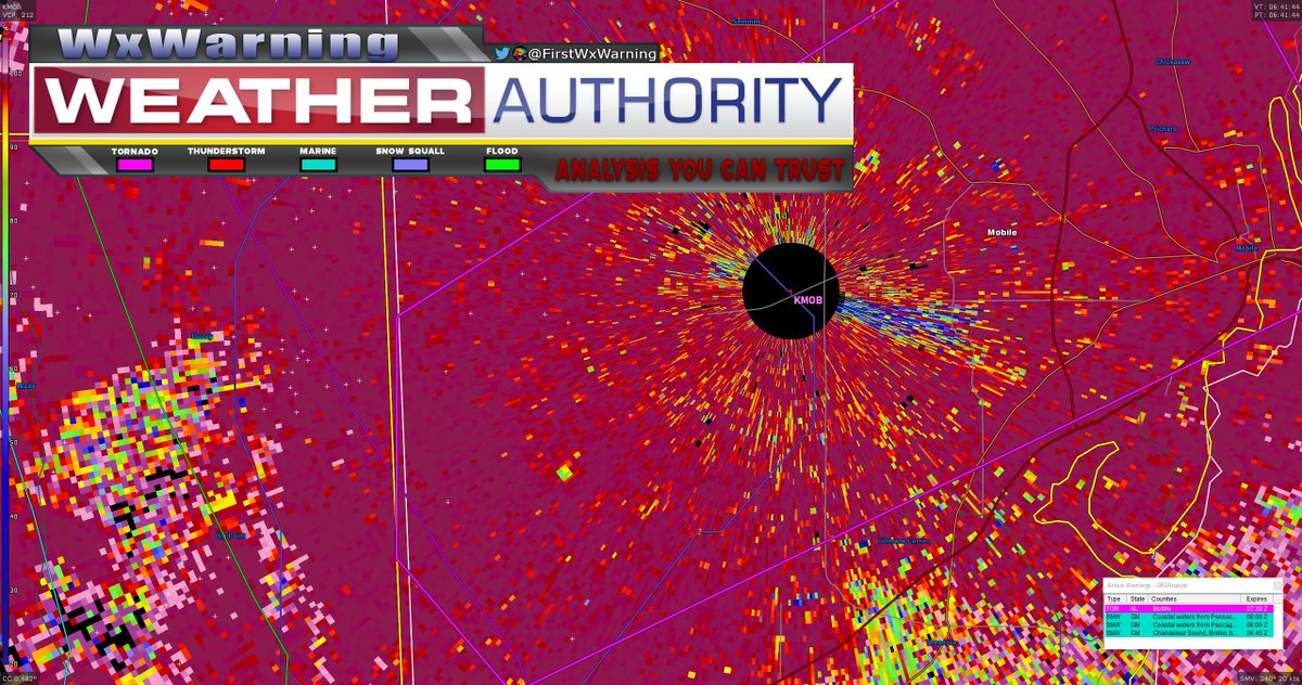
The tornadic couplet is somewhat difficult to distinguish given its proximity to the radar dome but it appears as though it is still on the ground and heading NE. I've circled the #tornado on the radar display #severewx#severeweather#alwx#Alabama#wx
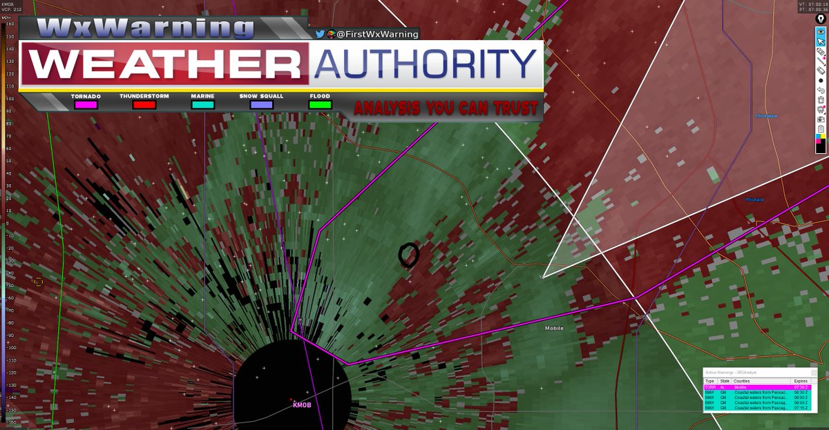
Likely #tornado just touched down SW of Mobile #Alabama given the recent tornado warning issuance and subsequent CC drop. Mobile needs to take their tornado precautions NOW #severewx#severeweather#wx#alwx


![FirstWxWarning's tweet photo. [1/4] Analogs for tomorrows severe weather setup seem to favor N #Texas for the greatest #tornado threat. I generally agree with the percentage probabilities, however it does appear to be slightly displaced too far to the N. This is likely due...#severewx #severeweather #txwx #wx https://t.co/V6ITJGtKry](https://pbs.twimg.com/media/FOVrAkAWUAAOz6S.png)
![FirstWxWarning's tweet photo. [1/3] Monday is looking like an interesting #severeweather setup for Central/East #Texas with supercells initiating along the surface dryline ~4pm CST. #tornado #severewx #wx #txwx https://t.co/xQVqjkcNIp](https://pbs.twimg.com/media/FOTJiBCXMAIwuNb.jpg)

![FirstWxWarning's tweet photo. [4/4] All this considered, I think if you translate the box that I outlined a bit to the S, you will end up with a pretty accurate assessment of what tomorrow's #tornado threat will likely look like https://t.co/9FDKKO3Nay](https://pbs.twimg.com/media/FOVutTKXoAU3331.png)
![FirstWxWarning's tweet photo. [3/4] This difference also manifests itself when looking at the SigTor parameter comparing both the analog mean (black contours) and NAM (red contours) You can see the nose of the Sig #Tornado probability is much closer to the Red River than what the current CAM guidance suggests https://t.co/D1xqBmC41m](https://pbs.twimg.com/media/FOVsp9eWYAIYvRj.png)
![FirstWxWarning's tweet photo. [2/3] Near storm soundings do favor rapid upscale growth and cell splits which could be an inhibiting factor but a pronounced mid level EML should at least allow semi discrete development for several hours before the prevailing threat transitions to damaging winds across E Texas https://t.co/fhMTZ49vMw](https://pbs.twimg.com/media/FOTJkA6X0AQpRhX.jpg)


