Likely subtropical cyclone off the coast of Libya in the Mediterranean Sea with winds near 50mph at this time. Storm expected to weaken a little before reaching land to the southeast by tomorrow.
Tropical Weather Outlook 13:00 UTC March 17
Tropical Storm Narelle intensifying quickly as it enters the Coral Sea, and is likely to impact northern Queensland as a major cyclone.
New Mediterranean storm likely to make landfall in Libya tomorrow.
🚨 SEVERE WEATHER OUTLOOK 🚨
SLIGHT RISK (2/5) for Western Greece.
MARGINAL RISK (1/5) in Greece and the UK.
Risks:
📌 Waterspouts / Brief Spin-ups
📌 Damaging Winds
📌 Small Hail & Graupel
#Greece#UK#Weather#Storm#Winds
🚨 SEVERE WEATHER OUTLOOK 🚨
MARGINAL RISK (1/5) for Western Greece, the Ionian Sea, the Southern Adriatic, and coastal Western Turkey.
Risks:
📌 Waterspouts / Brief Spin-ups
📌 Isolated Damaging Winds
📌 Small Hail & Graupel
#Greece#Turkey#Italy#Croatia#Weather#Storm
🚨 SEVERE WEATHER OUTLOOK 🚨
SLIGHT RISK (2/5) for the Northern Coast of Spain, Western Turkey, and Cyprus.
Risks:
📌 Damaging Wind Gusts (90-100 km/h)
📌 Isolated Tornadoes & Waterspouts
📌 Marginal/Small Hail
#Spain#Turkey#Cyprus#Weather#Tornado#Wind#Europe
@PlaysSaheb We consider for the risk of waterspout type tornadoes hitting land, however we've noticed we overdo it and are trying to course-correct. In addition, ASTORP guidance is not the most accurate in resolving smaller scale scenarios
🚨 SEVERE WEATHER OUTLOOK🚨
SLIGHT RISK (2/5) for the western coast of Greece, the Aegean Sea and western coastal Turkey.
Risks:
📌 Waterspouts/Tornadoes
📌 Large hail
📌 Isolated damaging winds
#Turkey#Greece#Weather#Tornado#Hail
🚨 SEVERE WEATHER OUTLOOK🚨
SLIGHT RISK (2/5) for the western coast of Greece, the Aegean Sea and western coastal Turkey.
Risks:
📌 Waterspouts/Tornadoes
📌 Large hail
📌 Isolated damaging winds
#Turkey#Greece#Weather#Tornado#Hail
@TempestWatch The risk is for the possibility of severe (roughly 60mph+) winds associated with convective showers/thunderstorms. Typically winds of such showers weaken inland due to land friction and other factors, so the risk is primarily for coastal areas
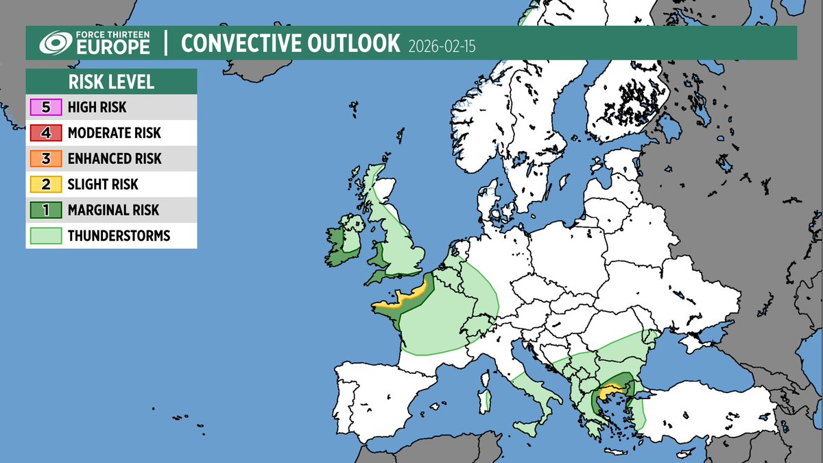
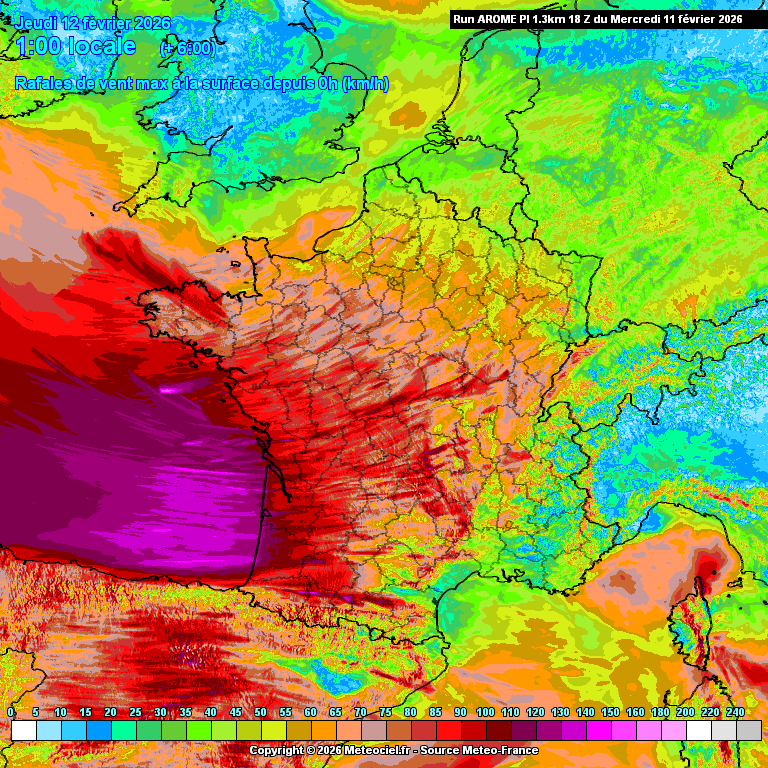
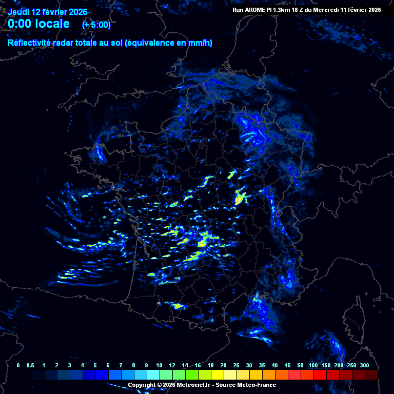
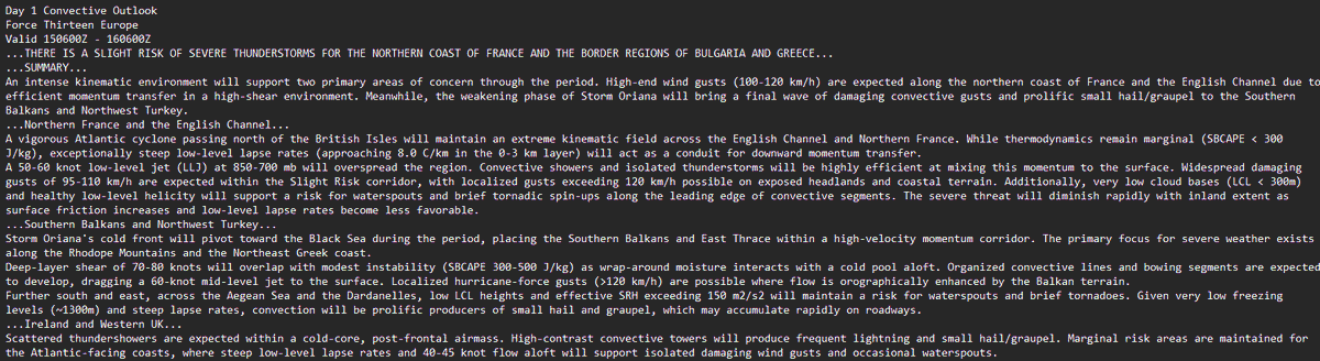
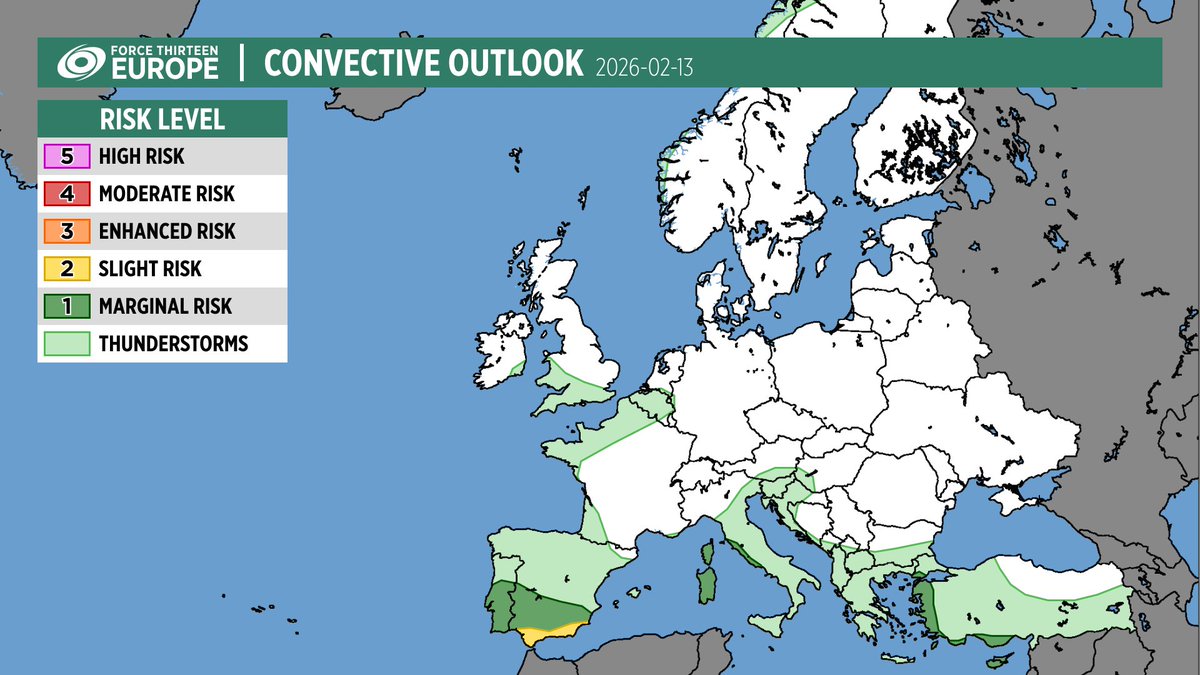
⛈️ CONVECTIVE OUTLOOK: Feb 15 ⛈️
SLIGHT RISK in place for:
🔸 Northern France & South UK Coast
🔸 NE Greece, S Bulgaria & NW Turkey
Primary Hazards:
💨 Damaging winds (100-120 km/h)
🌪️ Waterspouts & brief tornadoes
🧊 Prolific graupel/small hail
#StormOriana#Weather#Europe
Planning our schedule! 🗓️ Which is more helpful: a convective outlook posted the evening before, or a fresh update on the morning of? Let us know below! 👇 #Weather#Forecasting
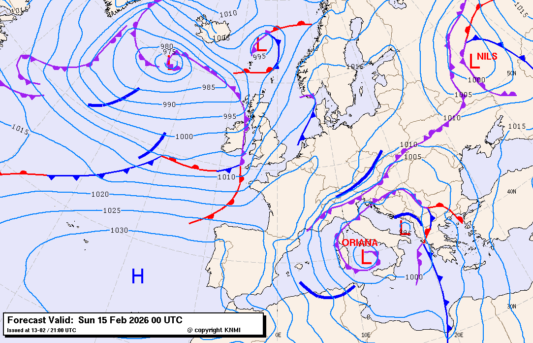
@anonymous57691 Hello. I'm not sure what you mean by "eye", extratropical systems do not have an eye. If you mean the center of the low, Oriana itself isnt likely to enter into there, but another weak low may form, as you can see on this chart. Courtesy KNMI
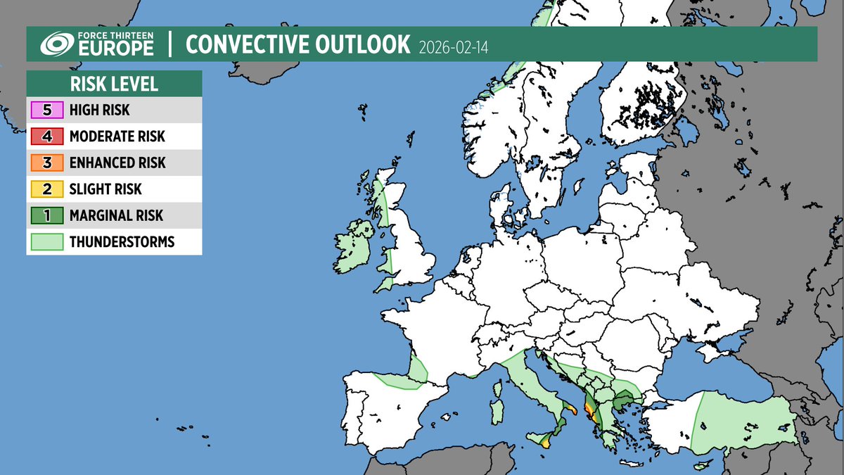
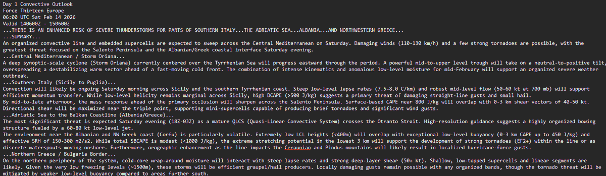
🚨 #StormOriana Convective Outlook 🚨
Significant severe weather threat for Feb 14 across Southern Italy, Albania, and NW Greece, with tornadoes and damaging winds the primary threat. Stay weather aware!
#Weather#Europe#Tornado#Albania#Greece#Italy
🚨 Severe Weather Outlook: Isolated thunderstorms across southern Europe today, with a small risk of a tornado / waterspout.
The main threat area is Portugal & Spain, where storms may produce damaging winds.
#SevereWeather#Thunderstorms#Tornado#Portugal#Spain
Watch out for potential of (strong) tornadoes and damaging, potentially hurricane force winds across France this evening into tonight in association with Storm Nils. #France#tornado
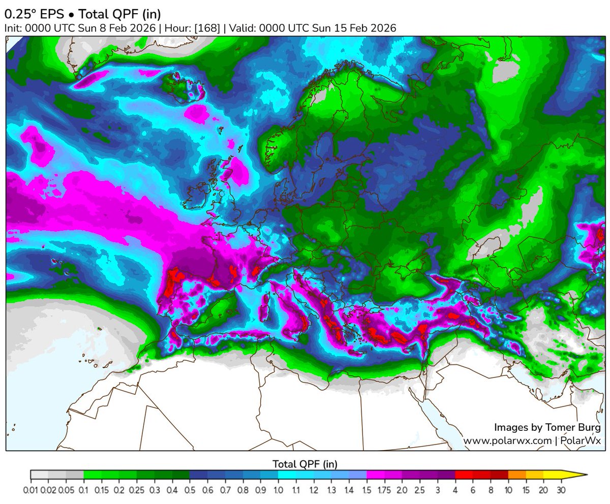
A washout across the Mediterranean & Western Europe 🌧️ 50 - 100 mm (2 - 4 in) more rain likely, locally higher. Flooding & thunderstorms threaten recovery - especially in Portugal after two damaging windstorms.
#Weather#Flooding#Portugal#Europe#Weather