Acaba de consumarse a maior traizón a Galiza en moito tempo. Rueda, Lorenzana e Vázquez actúan ao ditado de ALTRI. Que saiban que non llo imos permitir, hai unha xigantesca batalla legal e democrática por diante e imos gañar, vai gañar Galiza!
Te da miedo y risa al mismo tiempo?
Entonces, estás en el Entroido, una fiesta perversa, gamberra y ancestral!
Vamos de viaje por los #Carnavales más bizarros de #Galicia: genuino folk horror que puedes vivir en tus propias carnes durante estos días salvajes.
Te atreves a entrar?
El nivel de violencia al que se llega en el capitalismo es tan concreto y humillante para la clase trabajadora que hay pocas palabras para describirlo más allá de asco y espectaculo. «Sorteo de 28 viviendas públicas». No sois cómplices, sois los propios agentes y gestores de la
En los artículos que se publican en revistas científicas es obligatorio declarar conflictos de intereses. Tendría que ser obligatorio también en las cuentas de divulgación científica.
Una reflexión de #GranAngular:
Siguen saliendo muchísimos datos sobre el encarecimiento de la vivienda, pero ninguno termina de reflejar, de verdad, el impacto que han tenido estos cambios en el nivel micro; en la vida de las familias.
Vamos a probar con un experimento:
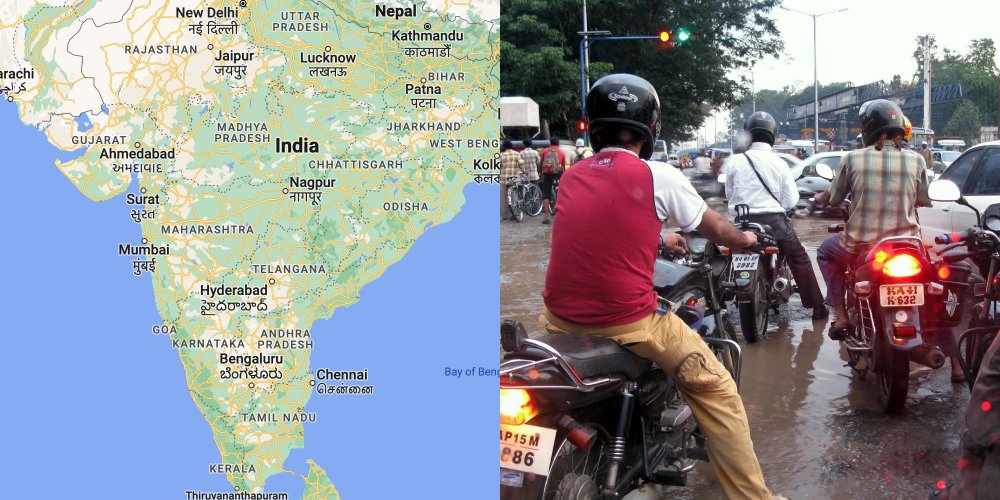
In 2008, Google Maps launched in India.
But we quickly ran into a problem:
Nobody used street names.
And street names were the foundation of Google Maps.
The team had to make some big adaptations.
15 years later, the changes have stood the test of time.
Here's how the team came up with creative solutions to adapt Google Maps to work in India:
–––
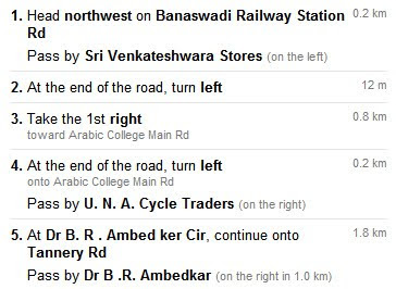
When Google Maps launched in India, turn by turn directions were unusable.
Because there were no road names, directions looked like this:
This was before real time, accurate GPS in phones had become mainstream.
In short, directions were pretty much useless in India.
–––
We could have left the product as it was.
We could have assumed it was good enough, would get better over time, or that eventually people would adapt.
But India was a massive potential market and we wanted the product to thrive.
The solution wasn’t just a case of acquiring and cataloging street names.
Many streets either didn’t have names, had multiple names, or weren’t known by their official names.
So we had to find an alternative.
We already knew that many communities around the world relied on landmarks (rather than street names) for navigating.
e.g. “Turn left at the park, head towards the water”
We knew this was also true in India.
But we had to confirm landmark based navigation would work.
And if it did, how we could make it work.
–––
So we dove in.
We started to explore how Google Maps could work if it oriented around landmarks.
But we needed to understand 2 key questions:
1. How did people use landmarks to navigate in India?
2. What types of landmarks were good for navigating?
This is where user research came in.
At the time, Google had robust support for user research.
There were research labs on campus with eye tracking technology and one-way mirrors.
There was a team dedicated to recruiting research participants.
But in this case, my friend and researcher extraordinaire, Olga (@okhroust) simply focused on how she could best answer these key questions.
She put together a creative and scrappy research plan.
And then she and Janet, the designer, hopped on a plane to India.
–––
What followed was nimble, on the ground field research to understand, first-hand, the answers to these questions.
They creatively explored various approaches including:
• Calling businesses and asking them for directions to their stores
• Asking people to draw diagrams of routes to familiar places
• Following people around as they navigated unfamiliar places
• Recruiting people to keep track of directions they gave or received + later interviewing them on their experiences
• Sharing early designs of landmark based directions and asking for feedback
Rather than relying on sophisticated technologies or being bounded by formal research methods, they creatively tried several different tactics to understand how locals navigated their way through India.
Olga and Janet found that people used landmarks to navigate in a few key ways:
• Orientation: “Head towards the water”
• Description of a turn: “Turn just past the Big Bazaar”
• Confirmation of the right path: “You'll see a petrol station on the right”
• Error correction: “If you get to the roundabout, you've gone too far”
Landmarks that were used for navigating included parks, monuments, shopping centers, notable buildings, stores, petrol stations, roundabouts, etc — basically anything that anyone would notice while on the road.
And so the team reworked turn-by-turn street directions to include navigational landmarks to help orient people, signal turns, confirm direction, and error correct.
The team worked through several iterations before landing on a final solution that emphasized landmarks, but also subtly included road names (when available):
–––
The research drove the product changes that helped transform Google Maps into the dominant navigational product for India.
A lot has changed in the last 15 years with the pervasiveness of location-enabled mobile phones, cheap mobile data, and generally how locals navigate in India.
But the use of landmarks to help people navigate through India has stood the test of time.
–––
What I love about this story and my 2 biggest takeaways are:
1. Research is a critical tool for ensuring you’re building a good product
2. Research can be as simple as just talking to people to answer your questions
tl;dr: If you are looking for answers, go talk to people.
For more on design + tips for early stage founders, follow @elizlaraki
🚨 SORTEO DOBLE 🚨
💥 Para compensar la cancelación del GP de Imola, sorteamos el pack camiseta + gorra de FERNANDO ALONSO.
✅ Seguir a @FormulaDirecta y @Ctinfo_17
🔁 RT a este tuit
☘️ ¡SUERTE! ☘️
#F1#Sorteo#Gratis
Imagina por un momento que eres un directivo en Meta, la empresa que agrupa Facebook, Instagram y WhatsApp. Hoy tienes la reunión mensual de análisis de la competencia, para observar y analizar los datos de tus principales rivales.
El primer gráfico que te enseñan es éste.
No entiendo por que los jóvenes estáis deprimidos si solo lleváis en crisis económica desde 2008, dos años de pandemia mundial y no podéis compraros ni un pajar iluminado con velas con 35 años bajo la amenaza de una guerra mundial.
Si puedes soñarlo, puedes hacerlo :-)
Non hai ningún dato máis sensible para medir a situación económica que este. Os mozos emigraron ou están no paro, ou traballan en precario…🤷🏻♂️🤷🏻♂️🤷🏻♂️
As políticas do @ppdegalicia só nos levan á miseria…
#GaliciaSenGoberno