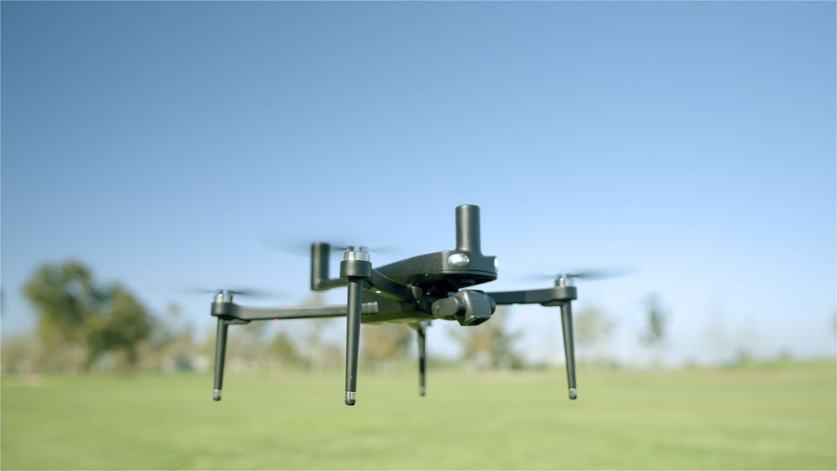
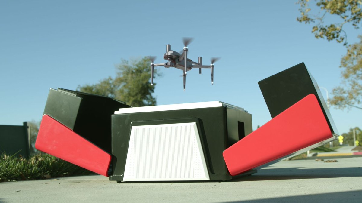
🚁 It’s LIVE -
GEO-SWARM just launched on Kickstarter.
A fully autonomous drone-in-a-box security system that deploys, patrols, docks, and recharges on its own.
Back the future of home security now:
https://t.co/OylrUDFzk5
We put the GEO-MEASURE and Trimble R12i head-to-head on the GEODNET RTK network - testing against real survey monuments in the Bay Area to see how close they really are.
Worth a watch if you're evaluating GNSS equipment or RTK correction services.
Solutions standing by.
Building the world's largest RTK network doesn't happen overnight. And neither does trust.
With every request we receive, our team is dedicated to helping customers deepen their understanding of our technology, feel confident in the products they've invested in, and resolve any challenges they encounter along the way.
GIP-13: StableHex is NOW LIVE.
Anyone can run a station, earn rewards, and help power precision location data worldwide.
Check out the incentives to join:
🔥 6x rewards: remote, zero-coverage areas (200 spots)
🔥 4x rewards: weak coverage zones (1,000 spots)
🔥 2x rewards: areas needing reinforcement (2,000 spots)
7-day uptime of ≥98% uptime = you're in.
Bonus multiplier is held and paid every 30 days.
99.5%+ = full bonus.
Drop below 90% = lose the spot
City streets. Open fields. Under the trees. Under dense canopy.
GEO-MEASURE held RTK Fixed through all of it - no base station, no setup, no compromise.
This is what professional RTK looks like when it just works.
In space, there is no centralized authority. On Earth, coordination has always had an authority behind it.
In my latest letter, I outline how blockchain enters as critical infrastructure.
https://t.co/EmZ5STvK94
From construction sites to open fields, accuracy matters.
GEO-MEASURE helps users collect high-precision location data for surveying, GIS,
mapping, agriculture, and site documentation.
When your work depends on exact points, centimeter-level RTK accuracy can make all the difference.
Get yours today.
$GEOD | @GEODNET has been one of the best performing robotics projects in this bad market.
In 2026:
Revenue → +154% ✅
Market Cap → +60% ✅
Price → +55% ✅
A project actually printing real revenue.
What do the on-chain numbers say?
Everything you need to know 👇
Grateful for the thoughtful analysis linked here by @Grid_Econ.
Real operators, real enterprise revenue, real-world use cases — drones, tractors, robots. A thorough breakdown of what GEODNET is actually building.
Big news! @GEODNET added to Coinbase's listing roadmap. Listing follows once market-maker support and technical infrastructure conditions are met.
Check out our recent cast study onGEODNET's tokenomics and design: https://t.co/gH6XKfRGt8
Coinbase adding $GEOD to its roadmap is a meaningful validation of GEODNET.
GEODNET is building the decentralized precision positioning layer the autonomous future actually needs.
A global network of 21,000+ user-operated RTK base stations across 160 countries already delivers centimeter-level GPS accuracy at scale.
That's the infrastructure powering robotics, drones, autonomous vehicles, precision agriculture, construction, and Physical AI.
This isn't vaporware or speculative infrastructure.
It generates real recurring revenue from enterprise customers who need reliable, high-accuracy location data.
The best part?
~80% of that data revenue is used to buy back and burn $GEOD.
As usage grows, supply shrinks.
A flywheel that directly aligns miners, token holders, and end users.
Miners earn GEOD for providing high-quality positioning data.
Businesses get a cheaper, more distributed alternative to traditional centralized RTK providers.
And the network has already become one of the largest precise positioning systems on the planet by node count.
Now running on Solana for better accessibility and lower costs, Coinbase placing $GEOD on the roadmap adds another layer of legitimacy and potential liquidity.
This is what real infrastructure adoption looks like:
• Proven hardware deployment
• Real paying customers
• Revenue-backed buybacks and burns
• Clear product-market fit
• Growing demand from robotics and autonomous systems
The robot economy needs a positioning layer. $GEOD is building it.
Every grape in this vineyard has a GPS coordinate.
@VineViewTech maps vineyards vine-by-vine using centimeter-accurate RTK from a handheld device. Powered by GEODNET.
What the positioning layer for Physical AI looks like in production.
In just 1 month, we'll be at @EsriUC 2026 🌍
It's the world's largest GIS conference, and we're excited to be part of it again. San Diego, here we come.
🗓 July 13–17 | Booth 526
San Diego Convention Center
Stay tuned for more details coming soon. #EsriUC2026#GIS
Hello Real World! Join us IRL in SF on June 18th for tier-one lab presentations on AI, biotech, neuroscience, longevity, robotics, makerspaces, human flourishing, art, and music. Make the physical world accessible to AI!
https://t.co/qxVZv5r2ru
I gave a presentation at the @allinsummit Liquidity Summit on June 2nd about a little known asset, solana:7JA5eZdCzztSfQbJvS8aVVxMFfd81Rs9VvwnocV1mKHu
My blog post about it is here - https://t.co/Ixv8VGZACR
And the YouTube video of my presentation is here
https://t.co/ct0r4jM1Ry
@GEODNET is live on peaqOS with https://t.co/DeR6AB2g8r
Any robot running peaqOS can utilise centimeter-precise positioning on demand
On any chain, paid autonomously, at scale
→ Delivery robot uses @official_naver for route
→ Uses GEODNET for precise navigation
→ Payments settled in USDT on @Solana via @WDK_tether
Check it out: https://t.co/KLTJ16PKhX