📌"ปรากฏการณ์ครั้งประวัติศาสตร์ ประเทศไทยเตรียมเปิดประตูสู่ยุคเศรษฐกิจอวกาศ จัด 3 งานใหญ่มหกรรมอวกาศระดับโลกแห่งปี 2026"
🔵เตรียมพบกับก้าวที่ยิ่งใหญ่ที่สุดของวงการอวกาศไทย กับการเป็นศูนย์กลางการจัดงานมหกรรมด้านเทคโนโลยีอวกาศระดับนานาชาติแห่งปี โดยการผนึกกำลังจัด 3 งานยักษ์ใหญ่ระดับโลกไว้ในคราวเดียวกัน ได้แก่ Thailand Space Expo 2026, APRSAF-32 และ Moon Village Association Workshop and Symposium ครั้งที่ 10 ซึ่งจะพลิกโฉมและยกระดับอุตสาหกรรมอวกาศไทยให้ก้าวไปสู่เวทีโลกอย่างเต็มภาคภูมิ
นี่ไม่ใช่เพียงการจัดนิทรรศการ แต่คือ "การประกาศจุดยืน" ว่าประเทศไทยพร้อมแล้วที่จะเป็นผู้นำด้านเทคโนโลยีและเศรษฐกิจอวกาศ (Space Economy) ในภูมิภาคเอเชียแปซิฟิก
👨🚀3 ปรากฏการณ์งานด้านอวกาศที่คุณต้องห้ามพลาด เพื่อตอกย้ำความยิ่งใหญ่ งานนี้ได้รวบรวมสุดยอดไฮไลต์จากทั่วทุกมุมโลกมาไว้ที่ประเทศไทย ประกอบด้วย:
1️⃣Thailand Space Expo 2026 ระหว่างวันที่ 28-31 ตุลาคม 2569 ณ ชั้น 7 ไอคอนฮอลล์ ไอคอนสยาม กรุงเทพฯ: มหกรรมแสดงเทคโนโลยีและนวัตกรรมอวกาศที่ยิ่งใหญ่ที่สุดในประเทศ พบกับการจัดแสดงชิ้นส่วนดาวเทียมของจริง นวัตกรรมล้ำยุคจากบริษัทอวกาศชั้นนำ และโอกาสทางธุรกิจใหม่ๆ ที่จะแสดงให้เห็นว่า "อวกาศไม่ใช่เรื่องไกลตัวอีกต่อไป" แต่เป็นโอกาสทองแห่งอนาคตสำหรับคนไทย
2️⃣APRSAF-32 (Asia-Pacific Regional Space Agency Forum) ระหว่างวันที่ 26 – 28 ตุลาคม 2569 ณ โรงแรมรอยัล ออคิด เชอราตัน ริเวอร์ไซด์ กรุงเทพฯ และระหว่างวันที่ 29 – 30 ตุลาคม 2569 ณ ชั้น 7 ไอคอนฮอลล์ ไอคอนสยาม กรุงเทพฯ: การประชุมสุดยอดผู้นำและหน่วยงานด้านอวกาศในระดับภูมิภาคเอเชียแปซิฟิก ครั้งที่ 32 เวทีสำคัญที่รวมตัวแทนจากองค์กรอวกาศระดับโลก (เช่น NASA, JAXA, ESA) มาร่วมกำหนดทิศทาง นโยบาย และความร่วมมือด้านอวกาศระดับนานาชาติที่จัดขึ้นในบ้านเรา
3️⃣Moon Village Association Workshop and Symposium ครั้งที่ 10 ระหว่างวันที่ 26 – 27 ตุลาคม 2569 ณ ชั้น 7 ไอคอนฮอลล์ ไอคอนสยาม กรุงเทพฯ: ก้าวข้ามขีดจำกัดของโลกสู่อนาคตบนดวงจันทร์ การประชุมระดับนานาชาติที่เจาะลึกถึงวิสัยทัศน์ โครงการสำรวจ และการเตรียมความพร้อมเพื่อสร้าง ถิ่นฐานบนดวงจันทร์ ร่วมสัมผัสแนวคิดสุดล้ำจากการร่วมมือของนักวิทยาศาสตร์และวิศวกรชั้นนำทั่วโลก
ทำไมคุณถึงต้องมาร่วมเป็นส่วนหนึ่งของประวัติศาสตร์นี้?
• สำหรับนักธุรกิจและสตาร์ทอัพ: เปิดประตูสู่ "New S-Curve" ค้นหาโอกาสทางเศรษฐกิจในอุตสาหกรรมอวกาศ (Space Economy) ที่กำลังเติบโตอย่างก้าวกระโดด พร้อมสร้างเครือข่ายกับผู้นำในอุตสาหกรรม
• สำหรับเยาวชนและนักศึกษา: นี่คือโอกาสครั้งเดียวในชีวิตที่จะได้สัมผัสแรงบันดาลใจจากผู้เชี่ยวชาญระดับโลก จุดประกายความฝันสู่อาชีพในวงการอวกาศ STEM และนวัตกรรม
• สำหรับบุคคลทั่วไป: ร่วมตื่นตาตื่นใจไปกับเทคโนโลยีแห่งอนาคต สัมผัสความก้าวหน้าทางวิทยาศาสตร์ที่กำลังจะเปลี่ยนโลก และร่วมภาคภูมิใจไปกับก้าวสำคัญของประเทศไทย
"อวกาศ... เริ่มต้นที่นี่"
อย่าปล่อยให้ปรากฏการณ์ครั้งสำคัญนี้ผ่านไป มาร่วมเป็นส่วนหนึ่งของการผลักดันประเทศไทยสู่ยุคเศรษฐกิจอวกาศ และร่วมสัมผัสประสบการณ์ไปพร้อมกันในงานมหกรรมด้านอวกาศที่ยิ่งใหญ่ที่สุดแห่งปี 2026
📲📧Please Contact:
•Thailand Space Expo 2026
-> Sponsor & Exhibition Contact: 02-1414593
-> Email: [email protected]
•APRSAF-32 -> Email: [email protected]
•MVA (Moon Village Association) -> Contact: 033-046307
-------------------------------------------------------------------------
📌A Monumental Milestone for Thailand
Gateway to the "Space Economy" Era
Discover 3 World-Class Space Events of 2026
🔵Get ready to witness the greatest leap in Thailand's space sector as the country becomes the epicenter for international space technology events. We are uniting three massive global space events in one unprecedented gathering: Thailand Space Expo 2026, APRSAF-32, and the 10th Moon Village Association Workshop and Symposium. This powerful synergy will transform and elevate the Thai space industry, proudly positioning it on the global stage.
This is more than just an exhibition; it is a bold declaration. Thailand is ready to emerge as a leader in space technology and the Space Economy within the Asia-Pacific region.
👨🚀3 Must-Attend Space Phenomena: To underscore the magnitude of this initiative, we are bringing together top highlights from across the globe right here in Thailand, including:
1️⃣Thailand Space Expo 2026 (October 28–31, 2026, at 7th Floor, ICON HALL, ICONSIAM, Bangkok) The nation's largest space technology and innovation expo. Experience actual satellite components, cutting-edge innovations from leading space companies, and emerging business opportunities. This event proves that "space is no longer out of reach"—it is a golden opportunity for the future of all Thais.
2️⃣APRSAF-32 (The 32nd Asia-Pacific Regional Space Agency Forum) (October 26–28, 2026, at Royal Orchid Sheraton Riverside Hotel, Bangkok, and October 29–30, 2026, at 7th Floor, ICON HALL, ICONSIAM, Bangkok) The premier summit for space leaders and agencies in the Asia-Pacific. This crucial platform brings together representatives from world-renowned space organizations (such as NASA, JAXA, and ESA) to collaboratively shape the future, establish policies, and foster international space cooperation right here in our home country.
3️⃣The 10th Moon Village Association Workshop and Symposium (October 26–27, 2026, at 7th Floor, ICON HALL, ICONSIAM, Bangkok) Pushing Earth's boundaries toward a lunar future. This international symposium delves into the visions, exploration missions, and preparations for establishing human settlements on the Moon. Experience groundbreaking concepts born from the collaboration of top-tier scientists and engineers worldwide.
Why You Must Be Part of This Historic Event?
• For Youth and Students: A once-in-a-lifetime opportunity to be inspired by global experts, igniting dreams of careers in the space industry, STEM fields, and innovation.
• For Entrepreneurs and Startups: Unlock the "New S-Curve" and discover economic opportunities in the exponentially growing Space Economy while networking with key industry leaders.
• For the General Public: Marvel at the technologies of tomorrow, experience scientific advancements that will change the world, and share in the pride of Thailand's monumental leap forward.
"Space... Begins Here."
Do not let this momentous occasion pass you by. Join us in propelling Thailand into the cosmos and experience the unimaginable at the greatest space exposition of 2026
📲📧Please Contact:
•Thailand Space Expo 2026
-> Sponsor & Exhibition Contact: 02-1414593
-> Email: [email protected]
•APRSAF-32 -> Email: [email protected]
•MVA (Moon Village Association) -> Contact: 033-046307
#GISTDA #อว #Mhesi #TSX2026 #APRSAF32 #MVA #SpaceEconomy #SpaceTechnology #THAILAND
GISTDA เผยภาพเส้นทาง Bangkok Pride 2026 จากดาวเทียม: ชวนส่อง “กรุงเทพมหานคร” กับบทบาทเมืองแห่งความหลากหลาย
.
ใกล้เข้าสู่ “เดือนมิถุนายน” เดือนแห่งความเท่าเทียมและความหลากหลายทางเพศ วันนี้สำนักงานพัฒนาเทคโนโลยีอวกาศและภูมิสารสนเทศ (องค์การมหาชน) หรือ GISTDA ขอนำเสนอภาพเส้นทางการเดินขบวนพาเหรด “Bangkok Pride Month 2026” เพื่อนับถอยหลังสู่เดือนแห่งความภาคภูมิใจของกลุ่ม “LGBTQIA+” ที่กำลังจะมาถึง
.
กิจกรรม “Pride (ไพรด์)” ถูกจัดขึ้นหลายพื้นที่ทั่วโลก รวมถึงในประเทศไทย ซึ่งถือเป็นอีกหนึ่งจุดหมายสำคัญของนักท่องเที่ยว โดยมีการเดินขบวนสุดยิ่งใหญ่สะท้อนความหลากหลายทางเพศ มีจุดประสงค์เพื่อแสดงถึงความภาคภูมิใจของกลุ่ม LGBTQIA+ เฉลิมฉลองความเท่าเทียม รวมถึงสร้างความตระหนักรู้ต่อการยอมรับในสังคม
.
“LGBTQIA+” หรือ กลุ่มผู้มีความหลากหลายทางเพศ เป็นกลุ่มที่เคยเผชิญกับการถูกเลือกปฏิบัติจากบริบทและขนบธรรมเนียมดั้งเดิม ทำให้ถูกตัดสินและผลักสู่ชายขอบสังคม เหตุการณ์ที่เป็นจุดเปลี่ยนเกิดขึ้นในเดือนมิถุนายน ค.ศ. 1969 ที่นครนิวยอร์ก สหรัฐอเมริกา เมื่อเกิดเหตุจลาจลระหว่างตำรวจและกลุ่มผู้มีความหลากหลายทางเพศนานเกือบหนึ่งสัปดาห์ ปีถัดมากลุ่ม LGBTQIA+ จึงรวมตัวเพื่อเรียกร้องความเท่าเทียมและรำลึกถึงเหตุการณ์ดังกล่าว หลังจากนั้นได้มีการจัดกิจกรรมช่วงเดือนมิถุนายนอย่างต่อเนื่อง และพัฒนาเป็นกิจกรรมไพร์ดที่ถูกจัดขึ้นทั่วโลก
.
การเดินขบวนไพร์ดของประเทศไทยมีการจัดขึ้นในหลายพื้นที่ โดยอีกงานไฮไลต์สำคัญคือ “Bangkok Pride Month 2026” ในวันที่ 31 พฤษภาคมนี้ ด้วยแนวคิด “Patch the World with Pride : การถักทอโลกด้วยความภาคภูมิใจ” ภายใต้ความร่วมมือระหว่างนฤมิตรไพร์ด กรุงเทพมหานคร รวมถึงการสนับสนุนจากหน่วยงานภาครัฐและเอกชน ปีนี้มีการขยายเส้นทางการเดินขบวนถึง 4.8 กิโลเมตร โดย GISTDA เปิดภาพแผนที่จากดาวเทียม THEOS-2 ซึ่งแสดงจุดรวมพล 6 จุด เริ่มต้นจากแยกนรารมย์ (คลองช่องนนทรี) ต่อเนื่องตลอดถนนสีลมเรื่อยไปจนถึงหน้าคณะรัฐศาสตร์ จุฬาฯ หน้าคณะอักษรศาสตร์ จุฬาฯ ห้างสรรพสินค้าสยามพารากอน และสิ้นสุดที่สนามเทพหัสดิน
.
“ถนนสีลม” หนึ่งในถนนสายสำคัญของกรุงเทพฯ เริ่มต้นจากแยกศาลาแดงและสิ้นสุดที่แยกบางรัก นอกจากบทบาทด้านคมนาคม ถนนแห่งนี้ยังเป็นย่านศูนย์กลางทางธุรกิจ (Central Business District: CBD) แห่งแรกของกรุงเทพฯ อีกทั้งถนนสีลมยังมีสถานบันเทิงกระจายอยู่ตลอดแนว ทำให้มีความคึกคักและได้รับความนิยมจากกลุ่มผู้มีความหลากหลายทางเพศ โดยเป็นสถานที่เดินขบวนไพร์ดครั้งแรกของไทยในปี พ.ศ. 2542 ซึ่งเป็นการนำเสนอแนวคิดใหม่ในบริบทสังคมไทยขณะนั้น นับเป็นอีกจุดเริ่มต้นในการเปิดพื้นที่การแสดงออกให้กลุ่มผู้มีความหลากหลายทางเพศ ก่อนจะกลับมาจัดอีกครั้งในปี พ.ศ. 2565 เพื่อผลักดันร่างกฎหมายสมรสเท่าเทียมและจัดต่อเนื่องมาจนถึงปัจจุบัน
.
ก่อนจะเป็นถนนสีลมพื้นที่แห่งนี้เคยเป็นท้องทุ่งนามาก่อน โดยมีกังหันลมสำหรับการจัดการน้ำเข้านา รวมถึงมีโรงสีข้าวอยู่หลายแห่งกลายเป็นที่มาของชื่อ “สีลม” ในปัจจุบัน และเมื่อเศรษฐกิจของกรุงเทพฯ เริ่มขยายตัว พื้นที่บริเวณนี้จึงมีคนหลายกลุ่มเข้ามาตั้งถิ่นฐาน ทั้งชาวไทยเชื้อสายจีน ชาวไทยเชื้อสายอินเดีย และชาวต่างชาติที่เข้ามาทำธุรกิจ ส่งผลให้สีลมเป็นอีกหนึ่งย่านที่แสดงความหลากหลายในสังคม
.
นอกจากย่านสีลม “กรุงเทพมหานคร” ยังเป็นพื้นที่ที่โอบรับความหลากหลายของคนหลายกลุ่มมาตั้งแต่อดีต เนื่องจากทำเลที่ตั้งของเมืองอยู่ใกล้ปากอ่าวไทย ทำให้ชาวต่างชาติหลายกลุ่มเดินทางเข้ามาติดต่อค้าขายและตั้งถิ่นฐาน ทำให้ปัจจุบันยังพบร่องรอยของชุมชนชาวต่างชาติกระจายอยู่ในหลายพื้นที่ อีกทั้งกรุงเทพฯ เป็นเมืองหลวงและศูนย์กลางทั้งด้านการปกครอง เศรษฐกิจ รวมถึงการคมนาคมของประเทศไทย ส่งผลให้ดึงดูดคนจากหลากหลายภูมิภาคเข้ามาอาศัยและทำงานอย่างต่อเนื่อง โดยปัจจุบันจากข้อมูลประชากรตามทะเบียนราษฎรในพื้นที่ กรุงเทพฯ มีคนอาศัยอยู่ประมาณ 5.5 ล้านคน ซึ่งยังไม่รวมประชากรแฝงที่มีมากกว่า 3.3 ล้านคน (ข้อมูลจากกรมการปกครอง กระทรวงมหาดไทย พ.ศ. 2568) ทำให้กลายเป็นเมืองที่แสดงความหลากหลายในหลายมิติด้านสังคม ดังนี้
.
มิติทางวัฒนธรรม: จากที่กล่าวข้างต้นว่า กรุงเทพฯ เป็นเมืองที่คนหลากหลายเชื้อชาติเข้ามาตั้งถิ่นฐานตั้งแต่อดีต ส่งผลให้เกิดชุมชนที่มีความหลากหลายทางศาสนา ยกตัวอย่าง “ย่านบางรัก” ที่สะท้อนความหลากหลายทางความเชื่ออย่างเห็นได้ชัด ซึ่งจะพบทั้งวัดหัวลำโพงของศาสนาพุทธ วัดพระแม่ศรีอุมาเทวี (วัดแขก) ของศาสนาพราหมณ์ - ฮินดู มัสยิดฮารูนของศาสนาอิสลาม และอาสนวิหารอัสสัมชัญของศาสนาคริสต์ สถานที่เหล่านี้แสดงรากเหง้าของชุมชนที่หลากหลายทั้งด้านเชื้อชาติและความเชื่อ โดยความแตกต่างทางวัฒนธรรมส่งเสริมให้กรุงเทพฯ กลายเป็นเมืองพหุวัฒนธรรม อีกทั้งยังเป็นปัจจัยดึงดูดนักท่องเที่ยวจากทั่วโลก
.
มิติทางความคิด: กรุงเทพมหานคร มีประชากรอาศัยอยู่เกือบ 9 ล้านคน ทำให้เมืองแห่งนี้มีผู้คนหลากหลายช่วงวัย ตั้งแต่เด็ก วัยเรียน วัยทำงาน จนถึงผู้สูงอายุ เนื่องจากกรุงเทพฯ เป็นศูนย์กลางทางเศรษฐกิจที่มีแหล่งงานจำนวนมาก อีกทั้งยังเป็นศูนย์กลางการศึกษาที่มีสถานศึกษาหลากหลายระดับ และเป็นพื้นที่อยู่อาศัยของผู้สูงอายุในหลายชุมชน ซึ่งความหลากหลายของหลายช่วงวัยเหล่านี้ นำไปสู่ความแตกต่างทางความคิดและการใช้ชีวิต สามารถสังเกตได้จากความพยายามพัฒนาโครงสร้างพื้นฐานที่ออกแบบให้รองรับคนทุกกลุ่ม เช่นการขนส่งมวลชน การปรับปรุงทางเท้า และการเพิ่มพื้นที่สาธารณะ โดยมุ่งหวังสู่การเป็นเมืองที่ทุกคนสามารถเข้าถึงสิ่งอำนวยความสะดวกได้อย่างเท่าเทียม
.
มิติด้านความหลากหลายทางเพศ: เนื่องจากประชากรที่อาศัยอยู่อย่างหนาแน่นและหลากหลาย ทั้งวัฒนธรรมและวิถีชีวิต ทำให้พื้นที่นี้มีกลุ่ม LGBTQIA+ เข้ามาอาศัยอยู่จำนวนมาก จากปัจจัยด้านสังคมที่เปิดกว้างทางความคิดและการยอมรับ ประเทศไทยจึงถูกมองว่าเป็นเมืองที่ก้าวหน้าในการเปิดรับความหลากหลายทางเพศ อีกทั้งยังมีการผ่านร่างกฎหมายสมรสเท่าเทียม ซึ่งเป็นการรับรองการแต่งงานของเพศเดียวกัน โดยเป็นชาติแรกในเอเชียตะวันออกเฉียงใต้ นอกจากนี้รัฐบาลยังพยายามผลักดันเศรษฐกิจสีรุ้งในหลายมิติ ทั้งด้านการท่องเที่ยว ความงาม รวมถึงอุตสาหกรรมบันเทิง เช่น ซีรีส์วายที่กำลังเป็นที่นิยม อีกทั้งยังสนับสนุนการจัดกิจกรรมไพร์ดอย่างต่อเนื่อง เพื่อเป็นส่วนหนึ่งในการปูทางสู่การรับเป็นเจ้าภาพ World Pride 2030
.
จากส่วนหนึ่งของมิติทางด้านสังคมเหล่านี้ แสดงภาพให้เห็นว่า “กรุงเทพมหานคร” ไม่ได้เป็นเพียงศูนย์กลางของประเทศไทยเท่านั้น แต่ยังเป็นเมืองที่โอบรับความหลากหลายทั้งด้านเชื้อชาติ ศาสนา วัฒนธรรม และอัตลักษณ์ของผู้คน ท่ามกลางบริบทของผู้คนหลากหลายกลุ่มและกำลังก้าวไปสู่สังคมที่การเปิดกว้างทางความคิด ส่งผลให้กรุงเทพฯ กลายเป็นอีกเมืองสำคัญของโลกที่สะท้อนพลังการอยู่ร่วมกันในสังคมพหุวัฒนธรรม รวมถึงความเท่าเทียมของผู้คนในปัจจุบัน
________
GISTDA Reveals Satellite Imagery of the Bangkok Pride 2026 Route: Exploring “Bangkok” as a City of Diversity.
.
June, the month of equality and gender diversity, approaches. Today, the Geo-Informatics and Space Technology Development Agency (Public Organization), or GISTDA, proudly presents the “Bangkok Pride Month 2026” parade route as part of a countdown to the upcoming Pride month — a celebration of LGBTQIA+ pride.
.
Pride parades are held in various areas around the world. Thailand is one of the most significant tourist destinations and hosts one of the largest Pride parades that promotes gender diversity. The event aims to celebrate LGBTQIA+ pride, promote inclusivity, and raise awareness of acceptance in society.
.
LGBTQIA+ individuals, or gender-diverse people, are a group that has historically been subjected to discrimination based on social context and traditional customs. They have been judged and pushed to the margins of society. The turning point occurred in June 1969 in New York, USA, when a riot broke out between police and members of the LGBTQIA+ community, lasting for nearly a week. The following year, LGBTQIA+ communities gathered to demand equality and commemorate the event. Since then, events have been organized annually in June and developed into pride parades around the world.
.
Pride parades in Thailand are held in various locations across the country. One of the significant highlights is “Bangkok Pride Month 2026” on 31 May, under the concept “Patch the World with Pride,” in collaboration with Naremite Pride, Bangkok, and the supporters from the government and private sector. This year, the parade route spans 4.8 kilometers. GISTDA presents a map from the THEOS-2 satellite showing six landmarks of the event — starting at Nararom Intersection (Khlong Chong Nonsi), continuing along Silom Road all the way to the front of the Faculty of Political Science, Chulalongkorn University, the front of the Faculty of Arts, Chulalongkorn University, Siam Paragon shopping mall, and ending at Thephasadin stadium.
.
Silom Road is one of the most significant roads in Bangkok, running from Sala Daeng Junction to Bang Rak Junction. Furthermore, the road is the first Central Business District (CBD) of Bangkok. Silom Road also has entertainment venues scattered along the entire stretch — contributing to its lively atmosphere and popularity among LGBTQIA+ communities. The area was the first in Thailand to host a Pride parade in 1999, representing new ideas in Thai society at the time. This marked the beginning of opening spaces for LGBTQIA+ expression. It was held again in 2022 to push forward the marriage equality bill, and has continued to be organized up to the present day.
.
In the past, Silom Road was an area of rice fields with windmills used for water management, which led to the presence of several rice mills in the area and became the origin of the name “Silom. As Bangkok’s economy expanded, the area became home to diverse communities, including Thai-Chinese, Thai-Indian, and foreign business communities. Today, Silom is one of the districts that reflects the diversity of urban society.
.
Furthermore, the Silom district in Bangkok has been an area that embraces diversity among people for a long time. Due to the location of the city near the Gulf of Thailand, it attracted traders for trade and business, and settlement. Currently, traces of a foreign community are still found spread in various areas. Furthermore, Bangkok is the capital and the center of administration, economy, and transportation in Thailand. It has attracted people from other regions to settle and work continuously. Currently, population data is based on household registration in this area. Bangkok has a registered population of 5.5 million people. This does not include the additional undocumented population, more than 3.3 million people (Data from the Department of Provincial Administration, Ministry of Interior, 2025). This makes Bangkok a city that exhibits diversity in many social dimensions, as follows:
.
Cultural dimension: As mentioned above, Bangkok is a city that has long been a place where people from various regions have settled. This has resulted in religious diversity in urban areas. A clear example is the Bang Rak district, which reflects religious diversity. This area includes Wat Hualamphong (Buddhist temple), Wat Phra Mae Sri Uma Devi (Hindu temple), Haroon Mosque (Islamic mosque), and Assumption Cathedral (Christian cathedral). These places reflect the roots of diverse communities across different regions and religions. Cultural differences contribute to Bangkok being a multicultural city. Furthermore, it is a factor that attracts tourists from around the world.
.
Cognitive dimension: With a population of nearly 9 million people, Bangkok has a diverse range of ages, from children and students to working adults and the elderly, because Bangkok is the economic center and offers many job opportunities. Furthermore, Bangkok is a center of education with schools at various levels and is home to an elderly population in many urban communities. Due to generational diversity, differences in cognitive and way of life are reflected to develop urban infrastructure — including improvements in public transportation, sidewalk accessibility, and the expansion of public spaces — with the goal of creating a city where everyone can access public facilities equally.
.
Gender diversity dimension: Due to its densely populated areas and cultural and way of life diversity, many LGBTQIA+ communities live in this area, supported by social factors that promote openness in mindset and acceptance. Thailand is considered a progressive country in terms of gender diversity. Furthermore, a marriage equality bill has been passed — recognizing same-sex marriage, making Thailand the first country in Southeast Asia to do so. The government continues to support efforts to promote the “rainbow economy,” including tourism, beauty, and the entertainment industry, such as the growing popularity of Y-series, both domestically and internationally. It also supports Pride parades as part of paving the way toward hosting World Pride 2030.
.
From these societal dimensions, Bangkok is shown not only as the center of Thailand but also as a city that embraces diversity in ethnicity, religion, culture, and identity. Amid the coexistence of diverse communities and a society that is becoming increasingly open-minded, Bangkok has emerged as one of the world’s significant cities that reflects the power of multicultural coexistence and equality among people.
.
#GISTDA #อว
#กรุงเทพมหานคร
#ดาวเทียม #THEOS2
#BangkokPrideMonth2026
#HappyPrideMonth #LGBTQIA+
แลนด์บริดจ์ “ระนอง-ชุมพร” ประตูเชื่อมสองทะเล จุดเปลี่ยนภูมิรัฐศาสตร์ไทยกับการเป็นพื้นที่ยุทธศาสตร์ใหม่บนแผนที่โลก
.
“แลนบริดจ์ (Landbridge)” หรือ “สะพานเศรษฐกิจ” เป็นการพัฒนาโครงสร้างพื้นฐานด้านคมนาคม เพื่อเชื่อมทะเลอ่าวไทยและอันดามัน ปัจจุบันประเทศไทยกำลังศึกษาถึงความเป็นไปได้ มีเป้าหมายเพื่อลดระยะทางการขนส่งสินค้าทางทะเลระหว่างมหาสมุทรอินเดียและแปซิฟิก
.
แนวคิดการสร้างเส้นทางเชื่อมต่อสองฝั่งทะเลไทยมีมาหลายยุคสมัย ในอดีตมีความพยายามขุดคลองบริเวณแม่น้ำกระบุรี ซึ่งเป็นจุดที่แคบที่สุดระหว่างสองฝั่งที่เรียกว่า “คอคอดกระ” แต่ด้วยข้อกังวลด้านความมั่นคงและสภาพภูมิประเทศทำให้โครงการยุติลง โดยครั้งล่าสุดที่มีการผลักดันแนวคิดนี้ เกิดขึ้นในปี พ.ศ.2544 จากการจัดตั้งคณะกรรมาธิการวิสามัญของวุฒิสภา เพื่อศึกษาความเป็นไปได้ของ “คลองไทย” ซึ่งปรับเขตการศึกษาลงมายังพื้นที่ 9A (จังหวัดกระบี่ - สงขลา)
.
ด้วยข้อจำกัดด้านความมั่นคงและความเสี่ยงต่อระบบนิเวศทางทะเลจากแนวคิดการขุดคลอง จึงปรับแนวทางสู่ “แลนบริดจ์” ซึ่งเป็นการสร้างโครงข่ายถนนและรางเชื่อมต่อท่าเรือน้ำลึกทั้งสองฝั่ง โดยถูกผลักดันอย่างต่อเนื่องหลายยุคสมัย แลนด์บริดจ์สายแรกเริ่มขึ้นในปี พ.ศ.2536 ภายใต้แผนการพัฒนาเซาเทิร์นซีบอร์ด (Southern Seaboard Development Plan: SSB) เส้นทางกระบี่ - ขนอม เพื่อรองรับการขยายตัวของการขนส่งสินค้า รวมถึงยกระดับศักยภาพทางเศรษฐกิจของภาคใต้ โดยแล้วเสร็จในปี พ.ศ.2546 แต่ด้วยบริเวณการสร้างท่าเรือของแลนด์บริดจ์สายดังกล่าวอาจส่งผลเสียต่อระบบนิเวศ จากผลการศึกษาในปี พ.ศ.2538 ภายหลังจึงได้ปรับตำแหน่งการศึกษาไปยังหลายเส้นทาง แต่ข้อจำกัดด้านเศรษฐกิจและสิ่งแวดล้อม ทำให้โครงการถูกยุติลงอีกครั้ง
.
ตั้งแต่ปี พ.ศ.2561 ประเทศไทยกลับมาศึกษาเส้นทางใหม่อีกครั้ง โดยให้ความสำคัญกับจังหวัดระนอง - ชุมพร ภายใต้แผนพัฒนาตามระเบียงเศรษฐกิจพิเศษภาคใต้ (Southern Econ omic Corridor: SEC) โดยเส้นทางที่กำลังมีแผนการศึกษาจะพัฒนาท่าเรือน้ำลึกบริเวณแหลมอ่าวอ่าง จังหวัดระนอง และแหลมริ่ว จังหวัดชุมพรรวมถึงการสร้างทางหลวงพิเศษ (มอเตอร์เวย์) MR8 และรถไฟรางคู่ เพื่อเชื่อมระหว่างท่าเรือน้ำลึกทั้งสองฝั่ง โดยทั้งหมดถูกออกแบบให้เป็น “ทางเลื่อนสำหรับถ่ายโอนสินค้า” มีระยะทางประมาณ 90 - 109 กิโลเมตร เพื่อผลักดันประเทศไทยสู่ศูนย์กลางด้านคมนาคมของภูมิภาคเอเชียตะวันออกเฉียงใต้
.
ภาคใต้ของประเทศไทยถือเป็นภูมิภาคที่ได้เปรียบด้านภูมิประเทศ เนื่องจากมีลักษณะเป็น “คาบสมุทร” โดยฝั่งตะวันตกติดทะเลอันดามันเชื่อมต่อกับมหาสมุทรอินเดีย และทางฝั่งตะวันออกติดทะเลอ่าวไทยเชื่อมต่อกับมหาสมุทรแปซิฟิก ทำให้มีศักยภาพในการพัฒนาด้านการขนส่งทางทะเล โดยเฉพาะจังหวัดระนองและชุมพร ซึ่งเป็นหนึ่งในช่วงที่มีระยะเชื่อมระหว่างสองทะเลที่สั้นที่สุดของคาบสมุทรไทย จึงมีความเหมาะสมด้านระยะทางในเชิงทฤษฎี สามารถรองรับการเติบโตด้านคมนาคม โดยอาจเชื่อมโยงระหว่างเขตระเบียงเศรษฐกิจภาคใต้ (SEC) และภาคตะวันออก (EEC) ได้ในอนาคต
.
ถ้ามองในมุมของการแข่งขันด้านเศรษฐกิจ คาดการณ์ว่า “แลนบริดจ์สายระนอง - ชุมพร” หากถูกพัฒนาให้เกิดขึ้นจริง อาจกลายเป็นจุดเปลี่ยนสำคัญของภูมิรัฐศาสตร์ไทยและภูมิภาคเอเชียตะวันออกเฉียงใต้ เนื่องจากประเทศไทยมีข้อได้เปรียบด้านทำเลที่ตั้ง ซึ่งถือเป็นจุดศูนย์กลางของภูมิภาค ทำให้สามารถเชื่อมต่อมหาสมุทรอินเดียและแปซิฟิกได้โดยตรง ช่วยลดระยะเวลาการเดินทาง และความแออัดของ “ช่องแคบมะละกา” ซึ่งเป็นเส้นเลือดใหญ่ของการขนส่งทางทะเล อีกทั้งยังเป็นจุดยุทธศาสตร์หลักของภูมิภาคเอเชีย ปัจจุบันมีเรือสัญจรมากกว่า 100,000 ลำต่อปี คิดเป็นหนึ่งในช่องแคบที่มีการเดินเรือหนาแน่นเป็นอันดับ 2 ของโลก นอกจากนี้ยังเป็นเส้นทางการลำเลียงน้ำมันของโลกถึง 35% ส่งผลให้ช่องแคบดังกล่าวมีความเสี่ยงต่อการเกิดอุบัติเหตุ จากความแออัดของการสัญจรที่เพิ่มสูงขึ้นอย่างต่อเนื่อง ทั้งนี้ความเป็นไปได้ทางเศรษฐกิจต้องผ่านการศึกษาเชิงลึกด้านต้นทุนการขนถ่าย ปริมาณสินค้า และการแข่งขันในภูมิภาคต่อไป
.
จากข้อได้เปรียบด้านภูมิประเทศ ส่งผลให้แลนด์บริดจ์ถูกมองว่า อาจเป็นปัจจัยสำคัญในการยกระดับบทบาทประเทศไทยต่อภูมิรัฐศาสตร์และการคมนาคมทางทะเลของโลก อย่างไรก็ตาม ตามแนวแผนการก่อสร้างยังเป็นพื้นที่ที่มีทรัพยากรธรรมชาติสำคัญ เช่น ป่าชายเลนบริเวณชายฝั่ง แนวปะการังกับหญ้าทะเล สัตว์น้ำ รวมถึงพื้นที่เกษตรกรรมและชุมชนประมงที่อยู่ตามแนวเส้นทาง จำเป็นต้องมีการประเมินอย่างละเอียดในขั้นต่อไป
.
กระบวนการประเมินดังกล่าว เทคโนโลยีอวกาศและภูมิสารสนเทศสามารถเข้ามามีบทบาท ตั้งแต่จัดทำแผนที่ เพื่อใช้วิเคราะห์เส้นทางด้วยข้อมูลจากดาวเทียมความละเอียดสูง จนถึงติดตามความเปลี่ยนแปลงของระบบนิเวศชายฝั่งและป่าด้วยเทคโนโลยีการรับรู้จากระยะไกล (Remote Sensing) รวมถึงวิเคราะห์ความเสียหายที่จะเกิดขึ้นอย่างต่อเนื่องระยะยาว เนื่องด้วยโครงการนี้อาจมีผลต่อสิ่งแวดล้อมและวิถีชีวิตของคนในพื้นที่ ดังนั้นต้องให้ความสำคัญตั้งแต่การสำรวจ การประเมินทั้งด้านสิ่งแวดล้อมและบริบททางสังคม ตลอดจนการติดตามความเปลี่ยนแปลงอย่างใกล้ชิด เพื่อให้การพัฒนามีประสิทธิภาพควบคู่กับการลดความเสี่ยงต่อสภาพแวดล้อมและชุมชนให้มากที่สุด
.
แลนด์บริดจ์ระนอง - ชุมพร อาจไม่ใช่แค่คำตอบของการเดินเรือทางทะเลเพียงอย่างเดียว แต่คือโครงการที่เกี่ยวพันทั้งด้านเศรษฐกิจ สิ่งแวดล้อม สังคม และภูมิรัฐศาสตร์ แม้เราจะมีข้อมูลเชิงพื้นที่จากดาวเทียมเป็นเครื่องมือสำคัญในการสนับสนุนการศึกษา แต่การตัดสินใจขั้นสุดท้ายควรมาจากกระบวนการที่รอบคอบ ครอบคลุมในทุกมิติควบคู่กับการรับฟังเสียงของชุมชนอย่างแท้จริง ซึ่งอาจเป็นบททดสอบของไทยกับการก้าวสู่ศูนย์กลางการคมนาคมของภูมิภาค โดยยังรักษาทรัพยากรธรรมชาติและวิถีชีวิตดั้งเดิมของคนในพื้นที่ไว้ รวมถึงสร้างความยั่งยืนให้พื้นที่ได้หรือไม่ นี่คือโจทย์ใหญ่ที่คนไทยต้องร่วมกันจับตามอง
_________
The “Ranong-Chumphon” landbridge: a gateway connecting two seas, is a turning point in Thailand’s geopolitics and a new strategic point on the global map.
.
“Landbridge” is a transportation infrastructure development project designed to connect the Gulf of Thailand and the Andaman Sea. Currently, Thailand is studying possibilities to reduce shipping distances between the Indian and Pacific Oceans.
.
The idea of building a connection between the two Thai seas has been discussed for centuries. In the past, efforts were made to construct a canal near the Kraburi River, located at the narrowest part of the peninsula known as the “Kra Isthmus”. However, due to concerns about national defence and geographical limitations, the project was eventually abandoned. More recently, renewed efforts to advance this concept began in 2001 with the establishment of a special Senate committee to study the feasibility of the “Thai Canal.” The study later shifted its focus to Route 9A — covering areas in Krabi and Songkhla provinces.
.
Due to concerns over national security and potential risks to marine ecosystems from canal construction, the concept was later adapted into a “Landbridge” involving the construction of roads and railways to connect ports on both coasts. The idea has continued to evolve over the years. The first landbridge initiative was launched in 1993 under the Southern Seaboard Development Plan: SSB (Krabi - Khanom) — to support the expansion of maritime transport and assess the economic potential of Southern Thailand. The project was completed in 2003. However, environmental studies conducted in 1995 indicated that the proposed port development along the route could negatively affect local ecosystems. As a result, the project later shifted its focus to alternative routes. Nevertheless, economic and environmental constraints eventually led to the project's abandonment.
.
Since 2019, Thailand has returned to studying the new route, giving importance to the Ranong - Chumphon province area under the Southern Economic Corridor (SEC). The project includes the development of ports around Ao Ang Cape in Ranong province and Rio Cape in Chumphon province, along with the construction of Motorway (MR8) and double-track railways to connect ports on the coast overall — designed to be the “moving walkway for transferring goods”. It has a total length of 90 - 109 kilometers, aiming to position Thailand as a transportation hub of Southeast Asia.
.
Due to its geographical nature as a peninsula, southern Thailand is bordered by the Andaman Sea on the west, which connects to the Indian Ocean, and the Gulf of Thailand on the east, which connects to the Pacific Ocean, giving the region strong potential for maritime transport development. The Ranong–Chumphon area is located in one of the narrowest parts of the Thai peninsula; therefore, it is geographically well-suited in terms of distance and infrastructure development. It can further support the growth of transportation infrastructure and may be integrated with the Southern Economic Corridor (SEC) and the Eastern Economic Corridor (EEC) projects in the future.
.
If viewed from the perspective of economic competition, the successful development of the “Ranong-Chumphon Landbridge” could become a turning point in Thailand’s geopolitics and in Southeast Asia. Thailand has a locational advantage as a central region that can connect the Indian and Pacific Oceans. It could reduce shipping distance and congestion in the Strait of Malacca. The Strait is a major maritime transport artery and a key strategic point in Asia. Currently, it handles more than 100,000 cargo ships per year — making it the second-busiest shipping route in the world. Furthermore, approximately 35% of global oil shipments pass through the strait. This makes the strait increasingly vulnerable to accidents due to growing traffic congestion. However, its economic feasibility requires further in-depth study of transportation costs, cargo volume, and regional competition.
.
From geographical advantages to the development landbridge, these factors may play a significant role in evaluating Thailand's position in geopolitics and global transportation. Nevertheless, areas along the proposed route contain important natural resources such as coastal mangrove forests, coral reefs, seagrass beds, aquatic life, as well as agricultural areas and fishing communities. These require a more detailed assessment in the next step.
.
Space technology and geoinformatics can play an important role in the evaluation process. By using satellite data and remote sensing, high-resolution mapping can be conducted to analyze routes and continuously monitor changes in coastal ecosystems and forests over the long term.
This project may affect the environment and the way of life of people in the surrounding areas. Therefore, it is essential to conduct environmental and social impact assessments, as well as continuous monitoring, to support efficient development and reduce risks to both the environment and local communities.
.
The Ranong-Chumphon Landbridge may not be the only key maritime transportation project; however, it is closely related to economic, environmental, social, and geopolitical dimensions. Satellite data can serve as a significant tool to support the study and analysis of the project. Nevertheless, the final decision should come from a careful and comprehensive process that considers all dimensions, together with genuinely listening to the voices of the local community — this may become a test for Thailand in its journey to becoming a regional transportation hub, while preserving natural resources, maintaining the traditional way of life of the local people, and ensuring long-term sustainability for the area. This is a major challenge that all Thais must collectively monitor.
.
#GISTDA #อว
#แลนด์บริดจ์ #SEC
#จังหวัดระนอง #จังหวัดชุมพร
เปิดตำนาน 3 เส้นทาง: พหลโยธิน-มิตรภาพ-พระราม 2 เส้นทางแห่งความคิดถึงในสายตาของดาวเทียม
.
“สุขสันต์วันสงกรานต์” เป็นประเพณีไทยที่มีมาอย่างยาวนาน คำว่า “สงกรานต์” มีรากศัพท์จากคำว่า “สํกฺรานฺติ” (สัง-กราน-ติ) ในภาษาสันสกฤตแปลว่า “การเคลื่อนย้าย” จัดระหว่างวันที่ 13 - 15 เมษายนของทุกปี ซึ่งเป็นช่วงดวงอาทิตย์เคลื่อนจากราศีมีนเข้าสู่ราศีเมษ อันเป็นการเข้าสู่ศักราชใหม่ตามคติจากพราหมณ์-ฮินดู เดิมวันที่ 15 เมษายนถือเป็นวันขึ้นปีใหม่ไทย จนกระทั่งในปี 2483 รัฐบาลจึงเปลี่ยนมาเป็นวันที่ 1 มกราคมตามแบบสากล
.
ประเพณีสงกรานต์ถูกจัดขึ้นทั้งในประเทศไทยและประเทศเพื่อนบ้าน โดยแต่ละพื้นที่จะมีชื่อเรียกแตกต่างกัน ในประเทศไทยถือเป็นวันหยุดราชการ หลายพื้นที่มีการจัดกิจกรรมที่หลากหลาย เช่น ขนทรายเข้าวัด สรงน้ำพระ รดน้ำดำหัวผู้สูงอายุและเล่นน้ำกันอย่างสนุกสนาน ซึ่งสถานที่ยอดนิยมอย่าง ถนนสีลม ถนนข้าวสาร (กรุงเทพมหานคร) และรอบคูเมืองเชียงใหม่ ล้วนเป็นหมุดหมายสำคัญของนักท่องเที่ยว ขณะเดียวกันเป็นช่วงเวลาที่ผู้คนถือโอกาสนี้กลับภูมิลำเนาใช้เวลากับครอบครัว
.
วันนี้ GISTDA ขอนำเสนอภาพถ่ายจากดาวเทียมของเส้นทางที่ทำให้นึกถึงความรัก ความอบอุ่นและการรอคอยด้วยความมุ่งมั่นผ่าน 3 เส้นทางหลัก คือ
.
ทางปิ๊กบ้านเฮา…“ถนนพหลโยธิน” หรือทางหลวงแผ่นดินหมายเลข 1 เริ่มต้นจากกิโลเมตรที่ 0 อนุสาวรีย์ชัยสมรภูมิ กรุงเทพมหานคร พาดผ่านหลายจังหวัดทั้งในภาคกลางถึงภาคเหนือ สิ้นสุดที่ด่านพรมแดนแม่สาย จังหวัดเชียงรายมีความยาว 994.749 กิโลเมตร เดิมมีชื่อว่า “ถนนประชาธิปัตย์” ก่อสร้างตั้งแต่ปี 2479 เพื่อวางแผนเป็นเส้นทางยุทธศาสตร์ด้านความมั่นคงทางทหาร ก่อนเปลี่ยนชื่อเป็นถนนพหลโยธินปี 2493 และพัฒนาโครงข่ายเชื่อมต่อภาคกลางกับภาคเหนือในเวลาต่อมา ส่งผลให้ถนนพหลโยธินมีความสำคัญทั้งทางด้านคมนาคมและเศรษฐกิจเชื่อมต่อการค้าระหว่างประเทศไทย - เมียนมา
.
ทางเมือเฮือนเฮา..“ถนนมิตรภาพ” หรือทางหลวงแผ่นดินหมายเลข 2 เริ่มต้นที่แยกจากถนนพหลโยธิน บริเวณอำเภอเมือง จังหวัดสระบุรี ก่อนสิ้นสุดที่จังหวัดหนองคายมีความยาว 509 กิโลเมตร มีการอนุมัติโครงการจากรัฐบาลตั้งแต่ปี 2493 โดยระยะแรกเริ่มจากจังหวัดสระบุรี - นครราชสีมา และระยะที่สองจังหวัดนครราชสีมา - หนองคาย ก่อนได้รับการสนับสนุนการก่อสร้างจากสหรัฐอเมริกาในปี 2498 จึงเป็นที่มาของชื่อ “ถนนมิตรภาพ” เปิดให้บริการอย่างเต็มรูปแบบในปี 2508 ถนนมิตรภาพเป็นเส้นทางบุกเบิกที่เปลี่ยนโครงสร้างการคมนาคมของภาคตะวันออกเฉียงเหนือไปตลอดกาล เนื่องด้วยในอดีตพื้นที่แห่งนี้มีความห่างไกลจากศูนย์กลาง อีกทั้งปัจจุบันยังทำหน้าที่เชื่อมต่อการค้าระหว่างประเทศไทย ลาว และจีน จึงมีโครงการเพื่อพัฒนาถนนสายนี้หลายโครงการ เช่น โครงการมอเตอร์เวย์ (บางปะอิน-นครราชสีมา) เพื่อขยายศักยภาพในการรองรับรถยนต์และลดระยะเวลาการขนส่งสินค้าในอนาคต
.
ทางหลบเรินโหม๋เรา…“ถนนพระราม 2” หรือทางหลวงแผ่นดินหมายเลข 35 (ดาวคะนอง-วังมะนาว) เริ่มต้นจากแยกสุขสวัสดิ์ เขตจอมทอง กรุงเทพมหานคร พาดผ่านจังหวัดสมุทรสาคร สมุทรสงคราม และบรรจบกับถนนเพชรเกษมบริเวณทางแยกต่างระดับวังมะนาว อำเภอปากท่อ จังหวัดราชบุรี เริ่มก่อสร้างตั้งแต่ปี 2513 เพื่อลดระยะเวลาการเดินทางและลดความหนาแน่นของถนนสายหลักอย่าง “ถนนเพชรเกษม” ถนนพระราม 2 คือ โครงข่ายสำคัญในการขนส่งผลผลิตทางการเกษตรและเชื่อมต่อท่าเรือสินค้าทางทะเลภาคใต้ ตลอดจนนำการเติบโตด้านการพัฒนาอสังหาริมทรัพย์ของย่านฝั่งธนบุรีและจังหวัดใกล้เคียงอย่างรวดเร็ว แต่ปัจจุบันถนนพระราม 2 ถูกวิจารณ์เรื่องระยะเวลาการก่อสร้าง เพราะยังมีการก่อสร้างและปรับปรุงอย่างต่อเนื่อง
.
การเดินทางช่วงเทศกาลสงกรานต์ต้องใช้ความระมัดระวังและสติในการขับขี่ เนื่องจากมีจำนวนรถบนท้องถนนเพิ่มขึ้น ความเร็วในการขับขี่สูง รวมถึงระยะเวลาการเดินทางที่ยาวนาน ก่อให้เกิดความเหนื่อยล้าและส่งผลอุบัติเหตุบนท้องถนนหลายกรณี จนต้องมีการเฝ้าระวังจากเจ้าหน้าที่อย่างใกล้ชิด ซึ่งส่งผลกระทบต่อความปลอดภัยของชีวิตและทรัพย์สิน อีกทั้งทำให้การจราจรในภาพรวมล่าช้าลงไปอีก
.
ดาวเทียมสามารถมองเห็นทุกสถานการณ์บนโลก ในอนาคตดาวเทียมสำรวจโลก (Earth Observation Satellites) โคจรอยู่บนวงต่ำ (Low Earth Orbit) มีศักยภาพในการถ่ายภาพรายละเอียดสูงและระบุวัตถุบนโลกได้อย่างแม่นยำ ไม่ได้มีบทบาทเพียงการสำรวจทรัพยากรธรรมชาติเเท่านั้น แต่ยังเข้ามามีบทบาทช่วยติดตามความหนาแน่นของการจราจร วิเคราะห์ทิศทางการเคลื่อนตัวของพาหนะ และสร้างแผนที่ที่มีการจราจรหนาแน่นเป็นประจำ เพื่อสนับสนุนการวางแผนจัดการจราจรในช่วงเทศกาล สามารถประยุกต์ข้อมูลจากดาวเทียมร่วมกับ AI เพื่อวิเคราะห์รูปแบบการเดินทาง ความหนาแน่นของการจราจร รวมถึงระบุตำแหน่งจุดชำรุดของพื้นถนน เพื่อนำไปสู่การวางแผนซ่อมแซมได้อย่างมีประสิทธิภาพเป็นอีกหนึ่งทางเลือกในการวางแผนการเดินทางของประชาชนและการจัดการเจ้าหน้าที่ในอนาคต
_________
Unveiling the legend of three routes: Phahonyothin–Mittraphap–Rama II — routes of nostalgia as seen through satellite eyes.
.
Happy Thai New Year — Songkran is a long-standing tradition in Thailand. The term comes from the Sanskrit word saṃkrānti (sang-kran-ti), meaning “transformation”. It is held from 13 to 15 April every year, as the sun moves from Pisces to Aries. It is a New Year festival according to Hindu tradition. In the past, 15 April was considered the Thai New Year. In 1940, the Thai government changed the official New Year to 1 January in accordance with international standards.
.
The Songkran festival is held in Thailand and neighboring countries. In other regions, it is known by a different name. In Thailand, it is a public holiday. Different regions have various activities, including carrying sand to temples, bathing Buddha statues, pouring water over elders’ heads as a sign of respect, and having fun playing in the water. Famous locations such as Silom Road, Khao San Road in Bangkok, as well as the moat area of Chiang Mai, are major destinations for tourists. During this time, many people also take the opportunity to return to their hometowns and spend time with their families.
.
Today, GISTDA presents satellite imagery that captures the nostalgia and significance of three main roads, seamlessly linking them with the traditions of Songkran:
.
The route to the northern region — Phahonyothin Road. Highway 1 starts at Kilometer 0 at Victory Monument, Bangkok, passes through many provinces from central to northern Thailand, and ends at the Mae Sai Border Checkpoint in Chiang Rai province. It has a total length of 994.749 kilometers. In the past, its name was Prachatipat Road, which was built in 1950. Subsequent development of road networks connecting central and northern Thailand made Phahonyothin Road crucial in terms of both transportation and the economy, facilitating trade between Thailand and Myanmar.
.
The route to the northeastern region — Mittraphap Road. Highway 2 starts at Phahonyothin Road in Mueang District, Saraburi Province, and ends in Nong Khai Province. It has a total length of kilometers. This project was approved by the government in 1950. The first phase starts from Saraburi to Nakhon Ratchasima, and the second phase is from Nakhon Ratchasima to Nong Khai. Before it was supported by the U.S. in 1955, it became the origin of the name Mittraphap Road. It officially opened in 1965 — Mittraphap Road pioneered the transformation of transportation infrastructure in Thailand’s northeastern region. Historically, this area was far from central Thailand. Recently, it has served as a trade corridor connecting Thailand, Laos, and China. Therefore, several development projects have been initiated for this road, such as the Bang Pa-in–Nakhon Ratchasima Motorway, to increase traffic capacity and reduce freight transport time in the future.
.
The route to the southern region—Rama II Road (Highway 35, Dao Khanong–Wang Manao section) starts at the Suk Sawat junction in Chom Thong District, Bangkok, passes through Samut Sakhon and Samut Songkhram Provinces, and merges with Phetkasem Road at the Wang Manao interchange in Ratchaburi Province. It was built in 1970 to reduce travel time and ease traffic congestion on major roads such as Phetkasem Road. Rama II Road serves as a transportation network for agricultural products and connects to the Southern Maritime Cargo Port. It has also driven rapid growth in real estate development in the Thonburi area and surrounding provinces. However, Rama II Road has been criticized for its prolonged construction timeline, as development and maintenance works are still ongoing.
.
Traveling during the Songkran festival requires caution, as traffic volumes, speeds, and travel times increase. This leads to driver fatigue and more road accidents, requiring close monitoring by authorities. This affects public safety and further causes traffic delays.
.
Satellites offer a new perspective for observing conditions on Earth. As technology advances, Earth Observation Satellites (EOS) in low Earth orbit will be able to capture high-resolution images and accurately identify objects on Earth's surface. Beyond natural resource exploration, their evolving role includes monitoring traffic density, analyzing vehicle movement patterns, and mapping areas of regular congestion to support traffic management during festivals like Songkran. With AI integration, satellite data can help analyze travel trends, assess traffic density, and identify road damage for more efficient repair planning—offering new alternatives for public travel planning and traffic management in the future.
.
#GISTDA #อว
#สงกรานต์69 #ดาวเทียม
จากข้อมูลสู่ขุมพลัง…เจาะลึก “โครงสร้างทางธรณีวิทยา” แนวทางการสำรวจน้ำมันและบทบาทของเทคโนโลยีดาวเทียม
.
ในยุคการแข่งขันด้านเศรษฐกิจ และเทคโนโลยี ทรัพยากรธรรมชาติจึงเข้ามามีบทบาทสำคัญ เช่น น้ำมันดิบ ถ่านหิน ก๊าซธรรมชาติ เพื่อแปรรูปมาเป็นพลังงานในภาคอุตสาหกรรม โดยเฉพาะ “น้ำมัน” ซึ่งนำมาใช้ประโยชน์ตั้งแต่การผลิต การขนส่ง รวมถึงใช้ในชีวิตประจำวัน
.
น้ำมัน (Refined Petroleum Products) เป็นผลิตภัณฑ์ที่ได้จากการกลั่นน้ำมันดิบ โดยมีองค์ประกอบหลักเป็นสารในกลุ่มไฮโดรคาร์บอน ซึ่งประกอบด้วยคาร์บอนและไฮโดรเจน รวมถึงสารประกอบอื่นในปริมาณเล็กน้อย ผลิตภัณฑ์เหล่านี้ถูกนำไปใช้เป็นเชื้อเพลิงในภาคพลังงาน การคมนาคมขนส่ง และการผลิตกระแสไฟฟ้า ส่งผลให้ความต้องการสำรวจและผลิตน้ำมันดิบเพิ่มสูงขึ้นอย่างต่อเนื่อง
.
ปิโตรเลียมมีแหล่งกำเนิดจากการสะสมและย่อยสลายของซากสิ่งมีชีวิตภายใต้สภาวะไร้ออกซิเจน เมื่อถูกทับถมเป็นเวลานาน สารอินทรีย์จะเปลี่ยนสภาพเป็นคีโรเจน หากมีการสะสมอยู่ในปริมาณมากพอที่จะให้กําเนิดปิโตรเลียมได้ เรียกว่า หินต้นกำเนิด (Source Rock) เมื่อหินต้นกำเนิดได้รับพลังงานความร้อนและความดันที่เหมาะสม คีโรเจนจะเกิดกระบวนการแปรสภาพกลายเป็นปิโตรเลียม จากนั้นจะเคลื่อนที่ผ่านรอยแตก รอยแยกและรูพรุนของชั้นหินไปสะสมในชั้นหินกักเก็บ (Reservoir) เช่น หินทรายหรือหินคาร์บอเนต โดยมีชั้นหินปิดทับ (Cap Rock) เพื่อกักเก็บปิโตรเลียมไว้ โดยทั่วไปมักพบโครงสร้างทางธรณีวิทยาที่เหมาะจะเป็นโครงสร้างปิดกั้น (Trap) และสะสมตัวของปิโตรเลียม เช่น โครงสร้างรูปโค้งประทุนคว่ำ (Anticline Trap) โครงสร้างรูปรอยเลื่อนของชั้นหิน (Fault Trap) โครงสร้างรูปโดม (Domal Trap) เป็นต้น ทำหน้าที่ป้องกันการรั่วไหลของปิโตรเลียมและลดการสัมผัสกับออกซิเจน อันช่วยชะลอกระบวนการย่อยสลาย ทั้งนี้ กระบวนการกำเนิด การเคลื่อนที่ และการสะสมตัวของปิโตรเลียมต้องเกิดขึ้นอย่างต่อเนื่องและสอดคล้องกัน หากขาดปัจจัยใดปัจจัยหนึ่ง จะไม่สามารถก่อให้เกิดแหล่งปิโตรเลียมที่มีศักยภาพในเชิงเศรษฐกิจได้
.
ประเทศไทยมีการสำรวจแหล่งพลังงานธรรมชาติใต้ดิน เช่น น้ำมันดิบและก๊าซธรรมชาติ แหล่งปิโตรเลียมในประเทศไทยกระจายตัวอยู่พื้นที่แอ่งสะสมตะกอน เชื่อมโยงกับรอยเลื่อนของชั้นหินยุคเทอเชียร์รีในภาคเหนือ (แหล่งฝาง) ภาคกลาง (แหล่งสิริกิติ์ วิเชียรบุรี สุพรรณบุรี และกำแพงแสน) และอ่าวไทย โดยค้นพบน้ำมันครั้งแรกปี พ.ศ. 2461 บริเวณอำเภอฝาง จังหวัดเชียงใหม่ หลังจากนั้นจึงเริ่มสำรวจอย่างจริงจัง โดยแหล่งน้ำมันบนบกที่ขนาดใหญ่และสำคัญที่สุดคือ “แหล่งสิริกิติ์” บริเวณรอยต่อ 3 จังหวัด ได้แก่ จังหวัดกำแพงเพชร สุโขทัย และพิษณุโลก จากข้อมูลเดือนมกราคม 2569 ของกรมเชื้อเพลิงธรรมชาติ กระทรวงพลังงานรายงานว่า แหล่งสิริกิติ์มีศักยภาพในการผลิตน้ำมันดิบ 23,321.90 บาร์เรลต่อวัน แต่ปริมาณน้ำมันที่พบในไทยมากกว่า 70% กระจายอยู่ในพื้นที่อ่าวไทย
.
“ประเทศไทยมีการค้นพบน้ำมัน แต่ทำไมปริมาณไม่เพียงพอต่อการใช้งาน” เพราะขนาดแหล่งน้ำมันดิบของไทยส่วนใหญ่เป็นแหล่งขนาดเล็กถึงปานกลาง ลักษณะที่พบคือ น้ำมันดิบจะกระจายตัวอยู่ตามรอยแยกหรือแตกของหินเรียกว่า “กระเปาะ” ยากต่อการสำรวจและขุดเจาะ เพราะมีกระบวนการหลายขั้นตอนและปริมาณน้ำมันดิบใต้ดินที่น้อย โดยเฉลี่ยแล้วประเทศไทยมีการผลิตจากทุกแหล่งทั้งหมดในประเทศเพียงแค่ 101,345.72 บาร์เรลต่อวัน คิดเป็น 10% ของปริมาณความต้องการของคนทั้งประเทศ จำเป็นต้องนำเข้าน้ำมันดิบเพื่อนำมากลั่นในโรงกลั่นน้ำมันภายในประเทศเพิ่มเติม
.
ด้วยวิวัฒนาการทางเทคโนโลยี ดาวเทียมจึงเข้ามามีบทบาทในการสำรวจแหล่งกำเนิดปิโตรเลียมมากขึ้น โดยนำเทคโนโลยีการสำรวจระยะไกล หรือ (Remote Sensing) มาประยุกต์ใช้ในการค้นหา เพื่อประเมินพื้นที่และศักยภาพ พร้อมระบุแหล่งสะสมปิโตรเลียมใต้ดินเบื้องต้นผ่านการวิเคราะห์ร่วมกับระบบภูมิสารสนเทศ (GIS) จากการตรวจับสัญญาณดาวเทียมที่แสดงพื้นผิวของโลกในวงกว้าง แต่ละพื้นที่จะมีการดูดกลืนค่าแสงต่างกันทำให้เห็นความต่างของพื้นที่สามารถแสดงข้อมูล เช่น ลักษณะภูมิประเทศ แหล่งน้ำ พืชพรรณ สามารถนำมาวิเคราะห์เพื่อเป็นข้อมูลสนับสนุนการสำรวจ ดังนี้
1) การวิเคราะห์ลักษณะภูมิประเทศ สามารถใช้ข้อมูล DEM จากดาวเทียมและข้อมูลภาพ LiDAR แสดงเป็นแบบจำลองภูมิประเทศ 3 มิติ แสดงรูปร่าง ความสูงของภูมิประเทศ ทิศทางน้ำ เพื่อให้วิศวกรและนักธรณีวิทยาสามารถค้นหา ประเมินตำแหน่งที่เหมาะสมในการขุดเจาะ วางแผนโครงสร้างพื้นฐาน เช่น ตำแหน่งที่ตั้งของโรงกลั่น ท่อขนส่งน้ำมัน เป็นต้น
2) การสร้างแผนที่โครงสร้างทางธรณีวิทยา ภาพจากดาวเทียมที่มีความละเอียดสูงตรวจจับได้จากการสะท้อนคลื่นที่ตาของดาวเทียมมองเห็น (VNIR) ร่วมกับคลื่น (SWIR) ซึ่งสามารถตีความแนวรอยเลื่อน แอ่งตะกอน การเปลี่ยนแปลงของหิน รวมถึงกำหนดลักษณะเฉพาะของหินแต่ละประเภทมาเป็นตัวแปรเพื่อจำแนก อาจนำอัตราการระบายน้ำ สิ่งปกคลุมดินและสภาพแวดล้อมมาร่วมวิเคราะห์ ซึ่งบ่งชี้โครงสร้างทางธรณีวิทยาที่อาจเป็นแหล่งที่มีปิโตรเลียมสะสมอยู่
3) การตรวจจับการรั่วซึมของปิโตรเลียม จากการการระเหยของไฮโดรคาร์บอนที่ซึมออกมาเหนือผิวดินหรือน้ำ รวมถึงติดตามความผิดปกติของพืชพรรณที่มีผลจากไฮโดรคาร์บอนที่ซึมมายังผิวดิน อาจทำให้พืชมีความผิดปกติ ผ่านการใช้ข้อมูลดาวเทียมติดตามความเปลี่ยนแปลงของค่าดัชนีพืชพรรณ (NDVI)
.
จริงอยู่ว่าดาวเทียมอาจไม่สามารถฉายภาพของแหล่งปิโตรเลียมได้โดยตรงแต่ปฏิเสธไม่ได้ว่า เทคโนโลยีอวกาศคือ ขุมกำลังสำคัญที่ทำให้คาดการณ์ได้ในเบื้องต้น คัดกรองพื้นที่เป้าหมายที่มีศักยภาพจากโครงสร้างธรณีที่น่าสนใจ ซึ่งอาจเป็นแหล่งสะสมปิโตรเลียม รวมถึงแร่ธาตุสำคัญเพื่อสนับสนุนข้อมูลการสำรวจภาคสนามโดยคลื่นไหวสะเทือนและการขุดเจาะในลำดับถัดไป ครอบคลุมถึงประเมินผลกระทบของสิ่งแวดล้อมจากการขุดเจาะปิโตรเลียม การรั่วไหลของสารพิษ การทรุดตัวของดิน ทำให้สามารถทำงานได้รวดเร็วและแม่นยำมากยิ่งขึ้น ลดความเสี่ยงในการลงทุน ช่วยให้การบริหารจัดการทรัพยากรให้เกิดประสิทธิภาพสูงสุด
__________
Unlocking Energy Potential: Analyzing Geological Structures and the Integration of Satellite Tech in Petroleum Exploration
.
In an era defined by economic and technological competition, natural resources—such as crude oil, coal, and natural gas—have become pivotal in fueling the industrial sector. Crude oil, in particular, remains a cornerstone of global operations, essential for everything from manufacturing and logistics to daily consumer life.
.
Refined petroleum products, derived from the distillation of crude oil, are primarily composed of hydrocarbons—organic compounds consisting of hydrogen and carbon—alongside trace amounts of other elements.
.
These products serve as the backbone of the global economy, acting as critical fuel sources for the energy sector, transportation, and power generation. Consequently, the world continues to see a steady surge in demand for crude oil exploration and production to sustain these vital industries.
.
Petroleum originates from the accumulation and decomposition of organic remains under anaerobic conditions. Over prolonged burial, organic matter transforms into kerogen, and when present in sufficient quantities to generate petroleum, the host formation is termed source rock. Under adequate heat and pressure, kerogen undergoes thermal conversion into petroleum, which then migrates through fractures, fissures, and porous rock until it accumulates within reservoir rocks — typically sandstone or carbonate — sealed above by an impermeable cap rock. Petroleum accumulations are commonly associated with geological trap structures, including anticline traps, fault traps, and domal traps, which prevent hydrocarbon leakage and limit oxygen exposure, thereby retarding degradation. Critically, the processes of generation, migration, and accumulation must occur in a continuous and coordinated sequence — the absence of any single element precludes the formation of an economically viable petroleum reservoir.
.
Thailand has been exploring underground natural energy resources, including crude oil and natural gas. The country's petroleum deposits are distributed across sedimentary basins linked to Tertiary-era fault lines in the North (Fang field), Central region (Sirikit, Wichian Buri, Suphan Buri, and Kamphaeng Saen oil fields), and the Gulf of Thailand. Oil was first discovered in 1918 in Fang District, Chiang Mai Province, marking the beginning of serious exploration efforts. The largest and most significant onshore oil field is the Sirikit Oil Field, located at the junction of three provinces — Kamphaeng Phet, Sukhothai, and Phitsanulok. According to January 2026 data from the Department of Mineral Fuels under the Ministry of Energy, the Sirikit Oil Field has a crude oil production capacity of 23,321.90 barrels per day. Nevertheless, more than 70% of Thailand's total oil reserves are distributed across the Gulf of Thailand.
.
Thailand has discovered oil, but why isn't production sufficient to meet domestic needs? The answer lies in the nature of its reserves — most of Thailand's crude oil fields are small to medium in scale. The oil is typically dispersed across fractured rock formations known as "pockets," making exploration and drilling both technically complex and costly. With multi-stage extraction processes and limited underground reserves, Thailand's total national production averages just 101,345.72 barrels per day — covering only 10% of the country's demand. The remainder must be met through crude oil imports for refining at domestic facilities.
.
As technology advances, satellites are playing an increasingly vital role in petroleum exploration. Remote sensing technology is now applied to identify and assess potential sites, with preliminary underground petroleum deposits mapped through integration with Geographic Information Systems (GIS). By capturing satellite signals reflecting Earth's surface across wide areas — where each zone absorbs light differently — analysts can distinguish terrain features, water sources, and vegetation patterns to support exploration in three key ways:
1) Terrain Analysis — Satellite-derived DEM data combined with LiDAR imagery generates 3D terrain models displaying landform shapes, elevation, and drainage direction. Engineers and geologists use this to identify optimal drilling locations and plan infrastructure such as refinery sites and pipeline routes.
2) Geological Structure Mapping — High-resolution satellite imagery using Visible Near-Infrared (VNIR) and Shortwave Infrared (SWIR) bands can interpret fault lines, sedimentary basins, and rock composition changes. Combined with drainage rates, land cover, and environmental data, these variables help classify rock types and identify geological structures with petroleum accumulation potential.
3) Petroleum Seepage Detection — Hydrocarbon vapors seeping above ground or water surfaces can be remotely detected. Satellites also monitor vegetation anomalies caused by subsurface hydrocarbon migration — which may stress or alter plant health — through analysis of the Normalized Difference Vegetation Index (NDVI).
.
While satellites cannot directly image petroleum reservoirs, space technology is undeniably a vital powerhouse for preliminary forecasting. It identifies high-potential target areas based on geological structures likely to contain petroleum or essential minerals, providing critical data to support subsequent seismic surveys and drilling operations. Furthermore, these technologies evaluate environmental impacts—ranging from oil spills to land subsidence—ensuring faster, more precise operations. Ultimately, this integration mitigates investment risks and optimizes resource management for maximum efficiency.
.
#GISTDA #อว
#น้ำมัน #พลังงงานไทย
#ดาวเทียม #ภูมิสารสนเทศ
ทักทายโลกจากห้วงอวกาศ
.
NASA เผยภาพประวัติศาสตร์หน้าใหม่ของโลก จากภารกิจ Artemis II ที่ถูกถ่ายจากนักบินอวกาศ เผยให้เห็นความงดงามของโลกท่ามกลางความมืดของอวกาศ ขณะยาน Orion กำลังเดินทางมุ่งหน้าสู่ดวงจันทร์
.
Cr. NASA - National Aeronautics and Space Administration
.
#GISTDA#อว
#NASA #NASAArtemis
#Artemis #ArtemisII
ถอดรหัส Artemis Program vs Artemis Accords ต่างกันอย่างไร ?
.
ในยุคที่มนุษยชาติกำลังนับถอยหลังสู่การกลับไปเยือนดวงจันทร์อีกครั้ง "อวกาศ" ไม่ใช่เรื่องไกลตัว หรือเป็นเพียงความฝันในภาพยนตร์ไซไฟอีกต่อไป แต่คือ "เศรษฐกิจใหม่" (Space Economy) และเวทีการทูตระดับโลกที่ทุกประเทศต่างมุ่งหวังที่จะมีส่วนร่วม คำถามที่หลายคนอาจจะยังสงสัยคือ โครงการยักษ์ใหญ่อย่าง Artemis Program และ Artemis Accords ของ NASA นั้นแตกต่างกันอย่างไร? และที่สำคัญ ประเทศไทยของเราอยู่ตรงจุดไหนในสมการระดับจักรวาลนี้? วันนี้เราจะมาเจาะลึกถึงความก้าวหน้า ความพร้อม และความโดดเด่นของ GISTDA (สำนักงานพัฒนาเทคโนโลยีอวกาศและภูมิสารสนเทศ) ที่กำลังพลิกโฉมประเทศไทยจาก "ผู้ใช้งาน" สู่ "ผู้ร่วมสร้าง" ในเวทีอวกาศระดับนานาชาติ
.
Artemis Accords และ Artemis Program ต่างกันอย่างไร?
เพื่อให้เข้าใจบริบทของการแข่งขันด้านอวกาศในโลกปัจจุบัน เราต้องแยกความหมายและบทบาทของสองคำนี้ออกจากกันอย่างชัดเจน
.
📷 Artemis Program (โครงการอาร์เทมิส) คือ "ตัวโครงการปฏิบัติการทางอวกาศ" ที่นำโดยองค์การ NASA ของสหรัฐอเมริกา โดยมีเป้าหมายเชิงประจักษ์ในการส่งมนุษย์ (รวมถึงผู้หญิงและคนผิวสีคนแรก) กลับไปเหยียบดวงจันทร์ โครงการนี้ครอบคลุมตั้งแต่การสร้างจรวด SLS, ยานอวกาศ Orion, การสร้างสถานีฐานบนผิวดวงจันทร์ (Lunar Base) และสถานีอวกาศโคจรรอบดวงจันทร์ (Gateway) เพื่อใช้เป็นจุดแวะพักในการเรียนรู้และทดสอบเทคโนโลยี ก่อนที่จะก้าวไปสู่เป้าหมายที่ยิ่งใหญ่กว่าในอนาคต นั่นคือการส่งมนุษย์เดินทางต่อไปยังดาวอังคาร
📷 Artemis Accords (ข้อตกลงอาร์เทมิส) คือ "กรอบความร่วมมือและกติกาสากล" ทางการทูตและกฎหมาย ว่าด้วยหลักการสำรวจและใช้ประโยชน์จากอวกาศ ดวงจันทร์ ดาวอังคาร และดาวเคราะห์น้อยอย่างสันติ โปร่งใส และยั่งยืน การลงนามในข้อตกลงนี้ ไม่ได้หมายความว่าประเทศนั้นๆ จะต้องสร้างจรวดไปดวงจันทร์ด้วยตนเอง แต่เป็นการแสดงจุดยืนร่วมกันในประชาคมโลก ว่าจะปฏิบัติตามกติกาที่ยอมรับร่วมกัน เช่น การช่วยเหลือบรรเทาภัยนักบินอวกาศ การเปิดเผยข้อมูลทางวิทยาศาสตร์ต่อสาธารณะ การปกป้องแหล่งมรดกทางประวัติศาสตร์บนดวงจันทร์ และการจัดการขยะอวกาศอย่างมีความรับผิดชอบ
.
ณ วันนี้ ประเทศไทยไม่ได้เป็นเพียงผู้ชมที่เฝ้ามองดวงดาวอีกต่อไป ความพร้อมและบทบาทของเราในเวทีอวกาศสากลมีความโดดเด่นและน่าจับตามองในหลายมิติ ดังนี้
1. การก้าวเข้าสู่สมาชิก Artemis Accords อย่างเป็นทางการ
เมื่อวันที่ 16 ธันวาคม 2567 ที่ผ่านมา ประเทศไทยได้สร้างประวัติศาสตร์หน้าใหม่ด้วยการลงนามเข้าร่วม Artemis Accords ทำให้เรากลายเป็นสมาชิกลำดับที่ 51 ของโลก และเป็นประเทศที่ 2 ในภูมิภาคอาเซียน (รองจากสิงคโปร์) ซึ่งการลงนามครั้งนี้เปรียบเสมือนการเปิดประตูบานใหญ่สู่การถ่ายทอดองค์ความรู้ เทคโนโลยีขั้นสูง และการร่วมลงทุนกับกลุ่มชาติตะวันตก
2. นโยบายการทูตอวกาศแบบสมดุล (Space Diplomacy)
ความโดดเด่นอย่างหนึ่งของยุทธศาสตร์ชาติไทยคือ นอกจากการร่วมมือกับฝั่งสหรัฐฯ ผ่าน Artemis Accords แล้ว ก่อนหน้านี้ไทยยังได้ร่วมลงนามในโครงการสถานีวิจัยนานาชาติบนดวงจันทร์ (ILRS) ซึ่งริเริ่มโดยประเทศจีนและรัสเซียด้วย ท่าทีนี้สะท้อนให้เห็นถึงความพร้อมและความชาญฉลาดด้านการทูตเชิงยุทธศาสตร์ ที่ไทยสามารถวางตัวเป็น "พันธมิตรในการพัฒนาวิทยาศาสตร์เพื่อสันติ" กับทุกขั้วมหาอำนาจได้อย่างสมดุล เปิดรับผลประโยชน์สูงสุดเข้าสู่ประเทศ
3. การเปลี่ยนผ่านจาก "ผู้ใช้" สู่ "ผู้สร้าง"
ไทยกำลังเปลี่ยนผ่านยุทธศาสตร์จากการเป็นเพียงประเทศที่ซื้อเทคโนโลยีหรือเป็นแค่ผู้ใช้ข้อมูลดาวเทียม มาเป็นผู้ร่วมวิจัยและพัฒนา (Co-developer) สร้างโอกาสให้กลุ่มนักวิจัย สตาร์ทอัพ และผู้ประกอบการไทยสามารถเข้าไปอยู่ในห่วงโซ่อุปทาน (Supply Chain) ของอุตสาหกรรมอวกาศและอิเล็กทรอนิกส์ขั้นสูงระดับโลกได้
.
ความโดดเด่นของ GISTDA และการเชื่อมโยงกับเหตุการณ์ปัจจุบัน
ในฐานะ National Focal Point หรือหน่วยงานหลักของชาติในการขับเคลื่อนภารกิจอวกาศ GISTDA มีบทบาทอย่างมาก โดยมีความก้าวหน้าที่สอดรับกับเมกะเทรนด์และเหตุการณ์ปัจจุบันอย่างเป็นรูปธรรม ดังนี้
1. โปรเจกต์แห่งอนาคต "Spaceport Thailand"
สอดรับกับกระแสการเติบโตของการปล่อยดาวเทียมเชิงพาณิชย์และธุรกิจอวกาศระดับโลก ปัจจุบัน GISTDA กำลังผลักดันและศึกษาความเป็นไปได้ในการจัดตั้ง "ท่าอวกาศยาน" (Spaceport) ในประเทศไทย โดยดึงข้อได้เปรียบทางภูมิศาสตร์ที่เราตั้งอยู่ใกล้เส้นศูนย์สูตร (ซึ่งช่วยประหยัดเชื้อเพลิงจรวดในการปล่อย) และมีพื้นที่แนวชายฝั่งที่เหมาะสม โครงการนี้หากเป็นรูปเป็นร่าง จะดึงดูดเม็ดเงินลงทุนต่างชาติและพลิกโฉมเศรษฐกิจไทยอย่างมหาศาล
2. การแสดงศักยภาพในงาน "Thailand Space Expo 2025"
ในเดือนตุลาคม 2568 GISTDA จัดงานมหกรรมอวกาศที่ยิ่งใหญ่ที่สุดในเอเชียตะวันออกเฉียงใต้ ภายใต้แนวคิด "United in Space: Building a Global Collaborative Future" งานนี้ไม่เพียงแต่จัดแสดงเทคโนโลยี แต่ยังเป็นเวทีจับคู่ธุรกิจ (Business Matching) ที่รวมนักลงทุนจากทั่วโลก สะท้อนวิสัยทัศน์ที่มุ่งมั่นจะให้ไทยเป็นศูนย์กลาง (Hub) ด้านเทคโนโลยีอวกาศของภูมิภาคเอเชียตะวันออกเฉียงใต้
3. การใช้ข้อมูลดาวเทียม THEOS-2 รับมือวิกฤตโลกปัจจุบัน
ความก้าวหน้าของ GISTDA ไม่ได้อยู่แค่เรื่องไกลตัวบนท้องฟ้า แต่ถูกนำมาเชื่อมโยงกับชีวิตประจำวันและปัญหาปัจจุบันอย่างลึกซึ้ง ซึ่งนำข้อมูลจากดาวเทียม THEOS-2 มาบูรณาการเพื่อการจัดการภัยพิบัติและสิ่งแวดล้อม ,การบริหารจัดการปัญหาน้ำท่วม-น้ำแล้งแบบ Near Real-time และการประเมินพื้นที่จุดความร้อน (Hotspot) เพื่อรับมือกับวิกฤตฝุ่นควัน PM 2.5 ที่เป็นวาระแห่งชาติ ,การยกระดับเกษตรกรรม โดยการใช้แอปพลิเคชันอย่าง Dragonfly เพื่อเสริมศักยภาพเกษตรกรไทยก้าวสู่ Smart Farming รวมถึงการใช้เทคโนโลยีจากภาพถ่ายดาวเทียมเพื่อเตรียมความพร้อมสำหรับการประเมินและติดตามคาร์บอนเครดิต ตอบโจทย์การเปลี่ยนแปลงสภาพภูมิอากาศ (Climate Change) เป็นต้น
4. การส่งเสริมคนรุ่นใหม่และ Startup Ecosystem
GISTDA เชื่อมโยงความก้าวหน้าเข้ากับทรัพยากรมนุษย์ ผ่านการจัดกิจกรรมระดับประเทศอย่าง GeoHackathon และ Dragonfly Challenge เพื่อเปิดพื้นที่ให้เยาวชน นักพัฒนา และสตาร์ทอัพไทย ได้นำข้อมูลจากดาวเทียมมาสร้างสรรค์เป็นโซลูชันและนวัตกรรมใหม่ๆ ที่ตอบโจทย์การใช้งานจริงและสร้างรายได้
.
ความแตกต่างระหว่างโครงการอาร์เทมิสและข้อตกลงอาร์เทมิส คือภาพสะท้อนของการผสมผสานระหว่าง "ความทะเยอทะยานทางวิทยาศาสตร์" และ "กติกาความร่วมมือของมวลมนุษยชาติ" สำหรับประเทศไทยแล้ว การตัดสินใจก้าวเข้าสู่สมรภูมิอวกาศในยุคปัจจุบัน ไม่ใช่การแข่งขันเพื่อนำธงชาติไปปักบนดวงจันทร์เพื่ออวดอ้างบารมี แต่คือการดึงเอาเทคโนโลยี นวัตกรรม และโอกาสทางเศรษฐกิจอันมหาศาลกลับลงมาสู่พื้นโลกเพื่อยกระดับคุณภาพชีวิตของประชาชน ซึ่ง GISTDA ในวันนี้ได้ดำเนินการเป็นผู้นำทางการทูตอวกาศ ผลักดันระบบนิเวศอุตสาหกรรมผ่านวิสัยทัศน์ Spaceport และประยุกต์ใช้เทคโนโลยีขั้นสูงเพื่อแก้ปัญหาปากท้องและสิ่งแวดล้อม เป็นเครื่องพิสูจน์แล้วว่า "อวกาศ" ไม่ใช่เรื่องไกลตัวอีกต่อไป แต่คือ "กุญแจสำคัญ" ที่จะปลดล็อกศักยภาพของประเทศไทย ให้ก้าวไปสู่อนาคตที่ยั่งยืน ก้าวล้ำ และแข็งแกร่งบนเวทีโลกได้อย่างเต็มภาคภูมิ
__________
Decoding the Difference: Artemis Program vs. Artemis Accords
.
In an era when humanity is counting down to its return to the Moon, "space" is no longer a distant concept or merely a dream from science fiction films. It has become a "Space Economy" and a global diplomatic arena that every nation is eager to participate in. A question many may still wonder about is: how exactly do the Artemis Program and the Artemis Accords — two of NASA's landmark initiatives — differ from one another? And more importantly, where does Thailand stand in this cosmic equation? Today, we take a deep dive into the progress, readiness, and growing prominence of GISTDA (the Geo-Informatics and Space Technology Development Agency), which is transforming Thailand from a mere "user" into a true "co-creator" on the international space stage.
.
How are the Artemis Accords and the Artemis Program different?
To understand the context of the space race in today's world, we need to clearly distinguish the meaning and role of these two terms from one another.
.
The Artemis Program is a spaceflight initiative led by NASA with the primary goal of returning humans—including the first woman and the first person of color—to the lunar surface. This program encompasses the development of the SLS rocket, the Orion spacecraft, the Lunar Base, and the Gateway (a lunar-orbiting space station). These assets will serve as a hub for learning and technology testing, providing a stepping stone toward a more ambitious future goal: sending humans to Mars.
.
The Artemis Accords are a diplomatic and legal "framework for international cooperation" regarding the principles for the peaceful, transparent, and sustainable exploration and utilization of outer space, the Moon, Mars, and asteroids. Signing these accords does not imply that a nation must build its own rockets to reach the Moon. Rather, it is a collective stance within the global community to adhere to mutually accepted rules. These include commitments such as providing emergency assistance to astronauts, releasing scientific data to the public, protecting historic heritage sites on the Moon, and managing space debris responsibly.
.
Today, Thailand has moved beyond being just an observer of the stars. Our capabilities and contributions to the global space stage are now significant and multifaceted in the following ways:
.
1. Officially Joining the Artemis Accords
On December 16, 2024, Thailand marked a historic milestone by signing the Artemis Accords, becoming the 51st member globally and the second in the ASEAN region (following Singapore). This signing serves as a gateway to the transfer of advanced knowledge and technology, as well as joint investment opportunities with Western nations.
.
2. Balanced Space Diplomacy
A standout feature of Thailand’s national strategy is its "Balanced Space Diplomacy." In addition to collaborating with the United States via the Artemis Accords, Thailand previously signed onto the International Lunar Research Station (ILRS) project led by China and Russia. This stance reflects strategic diplomatic intelligence, positioning Thailand as a "partner in peaceful scientific development" that maintains balance with all global superpowers to maximize national benefits.
.
3. Transitioning from "User" to "Creator"
Thailand is shifting its strategy from being a mere purchaser of technology or a satellite data consumer to becoming a Co-developer. This transition creates opportunities for Thai researchers, startups, and entrepreneurs to integrate into the global supply chain of the space industry and advanced electronics.
.
GISTDA's Distinction and Its Connection to Current Global Trends
As the National Focal Point — the country's lead agency driving the space mission — GISTDA plays a significant role, with progress that concretely aligns with global megatrends and current events, as follows:
.
1. The Future Project: "Spaceport Thailand"
In line with the growth of commercial satellite launches and the global space industry, GISTDA is currently pushing forward and studying the feasibility of establishing a "Spaceport" in Thailand. This initiative leverages Thailand's geographical advantage of being located near the equator (which reduces rocket fuel consumption during launches) and its suitable coastal areas. If realized, this project would attract massive foreign investment and profoundly transform the Thai economy.
.
2. Showcasing Potential at "Thailand Space Expo 2025"
In October 2025, GISTDA organized the largest space exhibition in Southeast Asia under the theme "United in Space: Building a Global Collaborative Future." The event was not only a technology showcase but also a business-matching platform bringing together investors from around the world, reflecting a determined vision to position Thailand as the space technology hub of Southeast Asia.
.
3. Using THEOS-2 Satellite Data to Address Current Global Crises
GISTDA's advancements are not confined to distant skies — they are deeply connected to everyday life and pressing issues. Data from the THEOS-2 satellite is integrated for disaster and environmental management, near real-time flood and drought management, and assessment of hotspot areas to address the PM 2.5 dust haze crisis, which is a national agenda. It is also used to advance agriculture through applications such as Dragonfly to empower Thai farmers toward Smart Farming, as well as to apply satellite imagery technology in preparation for carbon credit assessment and monitoring — addressing the challenge of climate change.
.
4. Empowering the New Generation and the Startup Ecosystem
GISTDA connects its progress to human capital development through national-level events such as GeoHackathon and Dragonfly Challenge, opening opportunities for youth, developers, and Thai startups to harness satellite data in creating innovative solutions that address real-world needs and generate economic value.
.
The distinction between the Artemis Program and the Artemis Accords reflects a fusion of "scientific ambition" and "the framework of cooperation for all of humanity." For Thailand, the decision to step into the space arena today is not about racing to plant a flag on the Moon as a display of prestige — it is about bringing technology, innovation, and enormous economic opportunity back down to Earth to elevate the quality of life for its people. GISTDA today, serving as a leader in space diplomacy, driving an industrial ecosystem through the Spaceport vision, and applying advanced technology to solve everyday and environmental challenges, has already proven that "space" is no longer a distant concept — it is the key that will unlock Thailand's potential and propel the nation toward a future that is sustainable, cutting-edge, and confidently strong on the global stage.
.
อ่านบทความอื่น ๆ ได้ที่ https://t.co/Pa0FZcJyi5
#GISTDA #อว #ArtemisAccords #NASA #SpaceEconomy #moon #เศรษฐกิจอวกาศ #เทคโนโลยี #อวกาศ
[2] ช่องแคบมะละกา “ทางเชื่อมโลกตะวันตกและโลกตะวันออก” ตั้งอยู่ทวีปเอเชียบริเวณคาบสมุทรมลายูคั่นระหว่างเกาะสุมาตรา ทำหน้าที่เชื่อมทะเลจีนใต้ มหาสมุทรแปซิฟิกและมหาสมุทรอินเดีย ส่วนที่แคบที่สุดมีความกว้างที่ 2.7 กิโลเมตร อีกทั้งยังเป็นทางผ่านของการขนส่งสินค้าทางทะเลที่มีความสำคัญต่อประเทศไทย ถือเป็นช่องแคบยุทธศาสตร์ด้านภูมิรัฐศาสตร์ รวมถึงด้านเศรษฐกิจของเอเชียตะวันออกและตะวันออกเฉียงใต้ เพราะเป็นเส้นทางที่มีการสัญจรทางทะเลหนาแน่นเป็นอันดับ 2 ของโลก รองรับเรือเกือบ 100,000 ลำต่อปี และเป็นเส้นทางการลำเลียงน้ำมันถึง 35% ของโลก รวมถึงก๊าซธรรมชาติจากกลุ่มประเทศอาหรับ ช่องแคบมะละกามีท่าเรือสำคัญตั้งอยู่หลายแห่ง เช่น ท่าเรือสิงคโปร์ ท่าเรือพอร์ตกลัง และท่าเรือมะละกา และเป็นศูนย์กลางที่เชื่อมตลาดประเทศฝั่งเอเชียเข้ากับยุโรป
.
ช่องแคบบับเอลมันเดบ “ประตูหลังของทะเลแดง” ตั้งอยู่รอยต่อระหว่างทวีปแอฟริกาและเอเชีย คั่นกลางระหว่างประเทศจิบูตี เอริเธีย และเยเมนส่วนที่แคบที่สุดกว้างประมาณ 26 เมตร ทำหน้าที่เชื่อมทะเลเมดิเตอเรเนียน ทะเลแดงออกสู่ทะเลอาหรับผ่านคลองที่ขุดขึ้นอย่างคลองสุเอซ เมื่อมีการขุดคลองสุเอซทำให้ช่องแคบแห่งนี้มีเรือสัญจรมากขึ้น เนื่องจากกลายเป็นประตูกลายเป็นด่านแรกในการขนส่งสินค้าจากทวีปเอเชียสู่ทวีปยุโรป โดยเฉลี่ย 1 วันมีเรือบรรทุกน้ำมันจากกลุ่มประเทศอาหรับประมาณ 6-8 ล้านบาร์เรล รวมถึงสินค้าอื่น ๆ ผ่านช่องแคบนี้ ทำให้ช่องแคบบับเอลมันเดบหากถูกควบคุมคลองสุเอซจะหยุดชะงักโดยทันที
.
คลองสุเอซ “ทางลัดสำคัญของโลก” ตั้งอยู่ประเทศอียิบต์ ซึ่งมีจุดเริ่มต้นที่พอร์ตซาอิตและสิ้นสุดที่พอร์ตสุเอซ ถือเป็นอีกหนึ่งคลองที่ถูกมนุษย์สร้างขึ้น มีความยาว 193.3 กิโลเมตร ซึ่งเป็นคลองขุดโดยมนุษย์ที่ยาวที่สุดในโลก มีความกว้าง 300-350 เมตร โดยขุดครั้งแรกปี 1859 ใช้เวลาขุด 10 ปี ก่อนเปิดให้บริการปี 1869 อยู่ระหว่างทวีปแอฟริกากับเอเชีย ทำหน้าที่เชื่อมมหาสมุทรแอตแลนติกและมหาสมุทรอินเดียผ่านทะเลเมดิเตอร์เรเนียนกับทะเลแดง คลองสุเอซช่วยลดระยะทางจากการอ้อมทวีปแอฟริกาบริเวณแหมกู๊ดโฮปที่เดิมใช้เวลา 8-10 วัน เหลือเพียง 11-16 ชั่วโมง โดยคลองสุเอซรองรับเรือประมาณ 25,000 ลำต่อปี คิดเป็น 12-14% ของการค้าโลก เป็นเส้นทางหลักในการขนส่งน้ำมัน ก๊าซธรรมชาติ รวมถึงสินค้าอุปโภคและบริโภคของทวีปยุโรป
.
คลองปานามา “เส้นเลือดใหญ่แห่งทวีปอเมริกา” ตั้งอยู่บริเวณตอนกลางของประเทศปานามาในอเมริกากลาง ทำหน้าที่เชื่อมมหาสมุทรแอตแลนติกและมหาสมุทรแปซิฟิกฝั่งตะวันออก มีความยาว 82 กิโลเมตร มีความกว้างน้อยที่สุด 91 เมตร โดยขุดครั้งแรกปี 1904 ก่อนแล้วเสร็จปี 1914 คลองปานามาช่วยลดระยะทางอ้อมทวีปอเมริกาใต้บริเวณแหลมฮอร์น เดิมใช้เวลาเกือบ 2 สัปดาห์ เหลือเพียง 10 ชั่วโมง โดยเป็นโครงการที่ท้าทายด้านวิศวกรรม รวมถึงการก่อสร้าง เนื่องด้วยการออกแบบและสร้างประตูกั้นน้ำถึง 12 ประตูเพื่อปรับระดับน้ำสำหรับการเดินเรือที่มีความแตกต่างของ 2 มหาสมุทร ทุกปีคลองปานามารองรับเรือเกือบ 15,000 ลำ สำหรับการขนส่งสินค้า เช่น รถยนต์ และพลังงานธรรมชาติของทวีปอเมริกา
.
เมื่อช่องแคบเหล่านี้คือ “เส้นเลือดใหญ่” ที่หล่อเลี้ยงเศรษฐกิจโลก การดูแลความปลอดภัยของเรือนับแสนลำจึงต้องอาศัยวิสัยทัศน์ที่กว้างไกลกว่าเดิม ปัจจุบันเทคโนโลยีอวกาศจึงเข้ามามีบทบาทสำคัญในการจัดการจราจรทางทะเล
.
ดาวเทียมในปัจจุบันไม่ได้ทำหน้าที่แค่ถ่ายภาพพื้นผิวโลก แต่ยังใช้คลื่นสัญญาณส่งลงมากระทบวัตถุบนผิวน้ำเพื่อสะท้อนกลับ ทำให้เราสามารถติดตามการเคลื่อนไหวและระบุพิกัดของเรือสินค้าต่างๆ ได้แบบ เรียลไทม์ เทคโนโลยีอวกาศจึงเปรียบเสมือน “ดวงตา” ที่คอยสอดส่องและควบคุมความปลอดภัย ยกระดับการสัญจรทางทะเลของโลกให้ราบรื่นและมีประสิทธิภาพมากยิ่งขึ้น
__________
.
The Strait of Malacca, “the Gateway Between East and West” — a vital waterway located in Asia along the Malay Peninsula, separating it from the Indonesian island of Sumatra. The strait serves as a critical connection between the South China Sea, the Pacific Ocean, and the Indian Ocean, with its narrowest point measuring just 2.7 kilometers wide. The waterway holds immense strategic importance — both geopolitically and economically — for East and Southeast Asia, including Thailand, where it serves as a key maritime shipping corridor. It ranks as the second busiest shipping lane in the world, handling nearly 100,000 vessels annually. The strait also carries approximately 35% of the world's oil shipments, along with significant volumes of natural gas from Arab nations. Several major ports are situated along the strait, including the Port of Singapore, Port Klang, and the Port of Malacca, cementing its role as a central hub connecting Asian markets with Europe.
.
The Bab-el-Mandeb Strait, “the Back Door of the Red Sea” — a critical maritime corridor at the intersection of Africa and Asia. Separating Djibouti and Eritrea from Yemen, this narrow passage—spanning roughly 26 kilometers at its tightest point—serves as the indispensable link between the Mediterranean and the Arabian Sea. Since the Suez Canal’s inception, the strait has evolved into a global trade artery, facilitating the daily transit of 6 to 8 million barrels of oil and vast quantities of dry cargo. Its strategic value is absolute: any disruption to the Bab el-Mandeb would effectively paralyze the Suez Canal, severing the primary energy and trade lifeline between Asia and Europe.
.
The Suez Canal, “the World’s Vital Shortcut” — spanning 193.3 kilometers across the Egyptian desert, the Suez Canal remains the world’s longest man-made waterway and a cornerstone of global logistics. Stretching from Port Said to Port Suez, this 350-meter-wide "shortcut" serves as the ultimate bridge between Africa and Asia. By linking the Mediterranean and Red Seas, the canal offers a direct passage between the Atlantic and Indian Oceans, slashing transit times from 10 days—the traditional route via the Cape of Good Hope—to a mere 11 to 16 hours. Today, the canal facilitates 12-14% of global trade, with approximately 25,000 vessels annually hauling essential oil, natural gas, and consumer goods to Western markets.
.
The Panama Canal, “the Lifeblood of the Americas” — serving as the primary maritime artery of the Western Hemisphere, the Panama Canal remains a cornerstone of global trade. Stretching 82 kilometers across Central Panama, this engineering marvel links the Atlantic and Pacific Oceans, effectively bypassing the perilous Cape Horn. By utilizing a sophisticated system of 12 locks to navigate varying water levels, the canal slashes transit times from nearly two weeks to a mere 10 hours. Today, it facilitates the passage of approximately 15,000 vessels annually, funneling essential commodities and automobiles across the globe.
.
As the primary lifelines of the global economy, these straits demand unprecedented oversight. With hundreds of thousands of vessels navigating these narrow corridors, space-based surveillance has shifted from a luxury to a necessity in securing modern maritime traffic.
.
Beyond mere imagery, modern satellites are leveraging advanced signal reflection to track cargo vessels in real-time. This orbital surveillance serves as a digital 'eye' in the sky, optimizing maritime traffic flow and bolstering global supply chain security.
.
#GISTDA #อว
#ช่องแคบ #ภาพถ่ายดาวเทียม
[1] รอยต่อทางภูมิประเทศ: จาก “ช่องแคบ”' ธรรมชาติ สู่เส้นเลือดใหญ่ทางภูมิศาสตร์ที่เชื่อมโลก สำรวจ 6 ช่องแคบสำคัญผ่านดวงตาจากอวกาศ
.
ช่องแคบเป็นเหมือน "เส้นเลือดใหญ่" การค้าโลก แม้จะเป็นเพียงพื้นที่เส้นทางน้ำ แต่ความสำคัญของมันนั้นมหาศาลทั้งในเชิงเศรษฐกิจ การเมืองและความมั่นคง เป็นทางลัดช่วยลดระยะเวลาประหยัดต้นทุนพลังงานการขนส่ง เป็นต้น ถือเป็นหนึ่งเครื่องมือทางภูมิศาสตร์ที่ถูกสร้างโดยธรรมชาติ แต่เป็นกลไกควบคุมทางเศรษฐกิจของทั้งโลกได้ เนื่องจากเป็นเส้นทางเชื่อมโลกมาตั้งแต่อดีตจนถึงปัจจุบัน
.
ช่องแคบ (Strait) “สเตรท” ลักษณะภูมิประเทศที่เป็นพื้นที่ทางทะเลทอดอยู่ระหว่าง 2 พื้นทวีปหรือเกาะ โดยในบางแห่งช่องแคบเป็นจุดเชื่อมรอยต่อของมหาสมุทร สาเหตุนี้ทำให้ช่องแคบเป็นพื้นที่ทรงอิทธิพลต่อภูมิรัฐศาสตร์ของโลก เพราะมีผลต่อปัจจัยเชิงพื้นที่ อีกทั้งได้รับปัจจัยจากมนุษย์ที่กำหนดนโยบายทางทะเล การสัญจรทางทะเลมีมาตั้งแต่อดีตเพราะเรือสามารถบรรทุกสิ่งของได้มากทั้งสินค้าอุปโภค บริโภค รวมถึงพลังงานธรรมชาติ เช่น น้ำมัน ก๊าซธรรมชาติ และแร่ธาตุสำคัญต่างๆ ในภาคอุตสาหกรรม เป็นต้น วันนี้แอดมินจะพาไปสำรวจ 6 ช่องแคบสำคัญผ่านดวงตาจากอวกาศ ซึ่งถือเป็นยุทธศาสตร์ที่สำคัญของโลกกันครับ
.
ช่องแคบฮอร์มุซ “ประตูน้ำมันจากตะวันออกกลาง” ตั้งอยู่ทวีปเอเชียคั่นระหว่างแหลมมุซันดัม ประเทศโอมาน สหรัฐอาหรับเอมิเรตส์ และอิร่าน ทำหน้าที่เชื่อมอ่าวเปอร์เซีย และอ่าวโอมานกว้างประมาณ 39 กิโลเมตรเป็นทางออกสู่มหาสมุทรอินเดียทางเดียวของกลุ่มประเทศผู้ค้าน้ำมันในเอเชียตะวันตกเฉียงใต้ (ตะวันออกกลาง) โดยเฉลี่ย 1 วันมีเรือบรรทุกน้ำมันประมาณ 17 ล้านบาร์เรล คิดเป็น 20% ของปริมาณน้ำมันโลก ยังมีการส่งออกก๊าซธรรมชาติเหลว คิดเป็น 1 ใน 4 ของโลกทำให้ช่องแคบฮอร์มุซมีผลต่อความมั่นคงด้านพลังงาน โดยเฉพาะประเทศที่พึ่งพาพลังงานจากกลุ่มประเทศอาหรับ ในทวีปเอเชียจะได้รับผลกระทบโดยตรง และประเทศไทยเองพึ่งพาน้ำมันกว่า 50% ทั้งนี้ ด้วยสถานการณ์ในปัจจุบันได้สร้างผลกระทบต่อเศรษฐกิจไทยทำให้ต้นทุนด้านพลังงานสูงขึ้นจากการขนส่งทางทะเล
.
ช่องแคบอังกฤษ “ประตูตะวันตกของทวีปยุโรป” ตั้งอยู่ทวีปยุโรปคั่นระหว่างประเทศอังกฤษ และประเทศฝรั่งเศส ทำหน้าที่เชื่อมต่อทะเลเหนือและมหาสมุทรแอตแลนติก อีกทั้งเป็นเส้นทางเชื่อมเกาะบริเตนใหญ่และแผ่นดินใหญ่ของยุโรป ส่วนที่แคบที่สุดอยู่บริเวณช่องแคบโดเวอร์มีความกว้างที่ 34 กิโลเมตร ช่องแคบอังกฤษมีความสำคัญมาตั้งแต่อดีต เป็นเส้นทางเชื่อมต่อไปยังอเมริกาผ่านมหาสมุทรแอตแลนติก ปัจจุบันถือเป็นช่องแคบที่มีเรือสัญจรมากที่สุดในโลก รองรับเรือประมาณ 500 ลำต่อวัน โดยการสัญจรในบริเวณนี้ต้องอาศัยความชำนาญ รวมถึงความระมัดระวังเพราะสภาพอากาศที่แปรปรวน คลื่นลมแรง และแรงดันน้ำสูง มีผลมาจากภูมิประเทศที่ตั้งอยู่ในมหาสมุทรแอตแลนติกประกอบกับกระแสน้ำอุ่นก่อให้เกิดความชื้น รวมถึงลมตะวันตกทำให้เกิดฝน อีกทั้งชายฝั่งยุโรปบริเวณช่องแคบอังกฤษถือเป็นแหล่งเพาะปลูกที่สำคัญ
__________
Geographic Arteries: A Satellite Perspective on the Six Straits That Define Global Commerce.
.
From natural straits to vital arteries of global trade, these geographical junctions connect the world. This study examines six significant straits from a space-based perspective.
.
Far more than mere waterways, the world’s primary straits function as the indispensable arteries of global commerce. These natural conduits serve as high-stakes geopolitical levers, offering critical shortcuts that drastically reduce transit times and fuel consumption. While carved by nature, they operate as a man-made mechanism for economic dominance, remaining the most vital links in the global supply chain from antiquity to the modern era.
.
A strait is a vital geographical feature — a narrow body of water that lies between two continents or islands. In many cases, straits serve as critical links between major oceans, elevating their importance in global geopolitics. These waterways shape not only physical geography but also maritime policies driven by human activity. Maritime navigation has existed since ancient times, as ships offer an efficient means of transporting large volumes of goods—from everyday consumer products to natural resources such as oil, natural gas, and essential industrial minerals. Today, we explore six of the world’s most strategically significant straits through a space-based perspective, revealing their crucial role in shaping global trade, security, and connectivity.
.
The Strait of Hormuz, “The Strategic Maritime Gateways” — Situated between the rugged cliffs of Oman’s Cape Musandam and the Iranian coastline, the Strait of Hormuz remains the world’s most sensitive maritime artery. As the sole exit for Persian Gulf crude, this narrow passage facilitates the transit of 17 million barrels daily—accounting for 20% of global oil supply and a quarter of worldwide LNG exports. For energy-dependent nations like Thailand, which relies on the Middle East for over 50% of its oil, the strait is more than a geographic landmark; it is a critical vulnerability. Current regional tensions are already manifesting in the Thai economy through surging logistics costs and heightened energy inflation.
.
The English Channel, “the Western Gateway of Europe” — located in Europe, serves as a natural boundary separating England and France. It connects the North Sea with the Atlantic Ocean and functions as a key maritime route linking Great Britain to the European mainland. Its narrowest point, the Dover Strait, spans just 34 kilometers wide. Historically, the English Channel has played a significant role as a gateway to the Americas via the Atlantic Ocean. Today, it holds the title of the world's busiest strait, handling approximately 500 vessels per day. However, navigation through this waterway demands considerable skill and caution. Mariners must contend with unpredictable weather conditions, strong winds, and powerful water currents — challenges that stem from its position in the Atlantic Ocean, where warm ocean currents bring high humidity and prevailing westerly winds generate frequent rainfall. Beyond its maritime significance, the European coastline along the English Channel is also recognized as a vital agricultural region, contributing to the economic importance of the area on both sides of the strait.
.
#GISTDA #อว
#ช่องแคบ #ภาพถ่ายดาวเทียม


![GISTDA's tweet photo. [2] ช่องแคบมะละกา “ทางเชื่อมโลกตะวันตกและโลกตะวันออก” ตั้งอยู่ทวีปเอเชียบริเวณคาบสมุทรมลายูคั่นระหว่างเกาะสุมาตรา ทำหน้าที่เชื่อมทะเลจีนใต้ มหาสมุทรแปซิฟิกและมหาสมุทรอินเดีย ส่วนที่แคบที่สุดมีความกว้างที่ 2.7 กิโลเมตร อีกทั้งยังเป็นทางผ่านของการขนส่งสินค้าทางทะเลที่มีความสำคัญต่อประเทศไทย ถือเป็นช่องแคบยุทธศาสตร์ด้านภูมิรัฐศาสตร์ รวมถึงด้านเศรษฐกิจของเอเชียตะวันออกและตะวันออกเฉียงใต้ เพราะเป็นเส้นทางที่มีการสัญจรทางทะเลหนาแน่นเป็นอันดับ 2 ของโลก รองรับเรือเกือบ 100,000 ลำต่อปี และเป็นเส้นทางการลำเลียงน้ำมันถึง 35% ของโลก รวมถึงก๊าซธรรมชาติจากกลุ่มประเทศอาหรับ ช่องแคบมะละกามีท่าเรือสำคัญตั้งอยู่หลายแห่ง เช่น ท่าเรือสิงคโปร์ ท่าเรือพอร์ตกลัง และท่าเรือมะละกา และเป็นศูนย์กลางที่เชื่อมตลาดประเทศฝั่งเอเชียเข้ากับยุโรป
.
ช่องแคบบับเอลมันเดบ “ประตูหลังของทะเลแดง” ตั้งอยู่รอยต่อระหว่างทวีปแอฟริกาและเอเชีย คั่นกลางระหว่างประเทศจิบูตี เอริเธีย และเยเมนส่วนที่แคบที่สุดกว้างประมาณ 26 เมตร ทำหน้าที่เชื่อมทะเลเมดิเตอเรเนียน ทะเลแดงออกสู่ทะเลอาหรับผ่านคลองที่ขุดขึ้นอย่างคลองสุเอซ เมื่อมีการขุดคลองสุเอซทำให้ช่องแคบแห่งนี้มีเรือสัญจรมากขึ้น เนื่องจากกลายเป็นประตูกลายเป็นด่านแรกในการขนส่งสินค้าจากทวีปเอเชียสู่ทวีปยุโรป โดยเฉลี่ย 1 วันมีเรือบรรทุกน้ำมันจากกลุ่มประเทศอาหรับประมาณ 6-8 ล้านบาร์เรล รวมถึงสินค้าอื่น ๆ ผ่านช่องแคบนี้ ทำให้ช่องแคบบับเอลมันเดบหากถูกควบคุมคลองสุเอซจะหยุดชะงักโดยทันที
.
คลองสุเอซ “ทางลัดสำคัญของโลก” ตั้งอยู่ประเทศอียิบต์ ซึ่งมีจุดเริ่มต้นที่พอร์ตซาอิตและสิ้นสุดที่พอร์ตสุเอซ ถือเป็นอีกหนึ่งคลองที่ถูกมนุษย์สร้างขึ้น มีความยาว 193.3 กิโลเมตร ซึ่งเป็นคลองขุดโดยมนุษย์ที่ยาวที่สุดในโลก มีความกว้าง 300-350 เมตร โดยขุดครั้งแรกปี 1859 ใช้เวลาขุด 10 ปี ก่อนเปิดให้บริการปี 1869 อยู่ระหว่างทวีปแอฟริกากับเอเชีย ทำหน้าที่เชื่อมมหาสมุทรแอตแลนติกและมหาสมุทรอินเดียผ่านทะเลเมดิเตอร์เรเนียนกับทะเลแดง คลองสุเอซช่วยลดระยะทางจากการอ้อมทวีปแอฟริกาบริเวณแหมกู๊ดโฮปที่เดิมใช้เวลา 8-10 วัน เหลือเพียง 11-16 ชั่วโมง โดยคลองสุเอซรองรับเรือประมาณ 25,000 ลำต่อปี คิดเป็น 12-14% ของการค้าโลก เป็นเส้นทางหลักในการขนส่งน้ำมัน ก๊าซธรรมชาติ รวมถึงสินค้าอุปโภคและบริโภคของทวีปยุโรป
.
คลองปานามา “เส้นเลือดใหญ่แห่งทวีปอเมริกา” ตั้งอยู่บริเวณตอนกลางของประเทศปานามาในอเมริกากลาง ทำหน้าที่เชื่อมมหาสมุทรแอตแลนติกและมหาสมุทรแปซิฟิกฝั่งตะวันออก มีความยาว 82 กิโลเมตร มีความกว้างน้อยที่สุด 91 เมตร โดยขุดครั้งแรกปี 1904 ก่อนแล้วเสร็จปี 1914 คลองปานามาช่วยลดระยะทางอ้อมทวีปอเมริกาใต้บริเวณแหลมฮอร์น เดิมใช้เวลาเกือบ 2 สัปดาห์ เหลือเพียง 10 ชั่วโมง โดยเป็นโครงการที่ท้าทายด้านวิศวกรรม รวมถึงการก่อสร้าง เนื่องด้วยการออกแบบและสร้างประตูกั้นน้ำถึง 12 ประตูเพื่อปรับระดับน้ำสำหรับการเดินเรือที่มีความแตกต่างของ 2 มหาสมุทร ทุกปีคลองปานามารองรับเรือเกือบ 15,000 ลำ สำหรับการขนส่งสินค้า เช่น รถยนต์ และพลังงานธรรมชาติของทวีปอเมริกา
.
เมื่อช่องแคบเหล่านี้คือ “เส้นเลือดใหญ่” ที่หล่อเลี้ยงเศรษฐกิจโลก การดูแลความปลอดภัยของเรือนับแสนลำจึงต้องอาศัยวิสัยทัศน์ที่กว้างไกลกว่าเดิม ปัจจุบันเทคโนโลยีอวกาศจึงเข้ามามีบทบาทสำคัญในการจัดการจราจรทางทะเล
.
ดาวเทียมในปัจจุบันไม่ได้ทำหน้าที่แค่ถ่ายภาพพื้นผิวโลก แต่ยังใช้คลื่นสัญญาณส่งลงมากระทบวัตถุบนผิวน้ำเพื่อสะท้อนกลับ ทำให้เราสามารถติดตามการเคลื่อนไหวและระบุพิกัดของเรือสินค้าต่างๆ ได้แบบ เรียลไทม์ เทคโนโลยีอวกาศจึงเปรียบเสมือน “ดวงตา” ที่คอยสอดส่องและควบคุมความปลอดภัย ยกระดับการสัญจรทางทะเลของโลกให้ราบรื่นและมีประสิทธิภาพมากยิ่งขึ้น
__________
.
The Strait of Malacca, “the Gateway Between East and West” — a vital waterway located in Asia along the Malay Peninsula, separating it from the Indonesian island of Sumatra. The strait serves as a critical connection between the South China Sea, the Pacific Ocean, and the Indian Ocean, with its narrowest point measuring just 2.7 kilometers wide. The waterway holds immense strategic importance — both geopolitically and economically — for East and Southeast Asia, including Thailand, where it serves as a key maritime shipping corridor. It ranks as the second busiest shipping lane in the world, handling nearly 100,000 vessels annually. The strait also carries approximately 35% of the world's oil shipments, along with significant volumes of natural gas from Arab nations. Several major ports are situated along the strait, including the Port of Singapore, Port Klang, and the Port of Malacca, cementing its role as a central hub connecting Asian markets with Europe.
.
The Bab-el-Mandeb Strait, “the Back Door of the Red Sea” — a critical maritime corridor at the intersection of Africa and Asia. Separating Djibouti and Eritrea from Yemen, this narrow passage—spanning roughly 26 kilometers at its tightest point—serves as the indispensable link between the Mediterranean and the Arabian Sea. Since the Suez Canal’s inception, the strait has evolved into a global trade artery, facilitating the daily transit of 6 to 8 million barrels of oil and vast quantities of dry cargo. Its strategic value is absolute: any disruption to the Bab el-Mandeb would effectively paralyze the Suez Canal, severing the primary energy and trade lifeline between Asia and Europe.
.
The Suez Canal, “the World’s Vital Shortcut” — spanning 193.3 kilometers across the Egyptian desert, the Suez Canal remains the world’s longest man-made waterway and a cornerstone of global logistics. Stretching from Port Said to Port Suez, this 350-meter-wide "shortcut" serves as the ultimate bridge between Africa and Asia. By linking the Mediterranean and Red Seas, the canal offers a direct passage between the Atlantic and Indian Oceans, slashing transit times from 10 days—the traditional route via the Cape of Good Hope—to a mere 11 to 16 hours. Today, the canal facilitates 12-14% of global trade, with approximately 25,000 vessels annually hauling essential oil, natural gas, and consumer goods to Western markets.
.
The Panama Canal, “the Lifeblood of the Americas” — serving as the primary maritime artery of the Western Hemisphere, the Panama Canal remains a cornerstone of global trade. Stretching 82 kilometers across Central Panama, this engineering marvel links the Atlantic and Pacific Oceans, effectively bypassing the perilous Cape Horn. By utilizing a sophisticated system of 12 locks to navigate varying water levels, the canal slashes transit times from nearly two weeks to a mere 10 hours. Today, it facilitates the passage of approximately 15,000 vessels annually, funneling essential commodities and automobiles across the globe.
.
As the primary lifelines of the global economy, these straits demand unprecedented oversight. With hundreds of thousands of vessels navigating these narrow corridors, space-based surveillance has shifted from a luxury to a necessity in securing modern maritime traffic.
.
Beyond mere imagery, modern satellites are leveraging advanced signal reflection to track cargo vessels in real-time. This orbital surveillance serves as a digital 'eye' in the sky, optimizing maritime traffic flow and bolstering global supply chain security.
.
#GISTDA #อว
#ช่องแคบ #ภาพถ่ายดาวเทียม](https://pbs.twimg.com/media/HEYa5TracAAp2sz.jpg)
![GISTDA's tweet photo. [2] ช่องแคบมะละกา “ทางเชื่อมโลกตะวันตกและโลกตะวันออก” ตั้งอยู่ทวีปเอเชียบริเวณคาบสมุทรมลายูคั่นระหว่างเกาะสุมาตรา ทำหน้าที่เชื่อมทะเลจีนใต้ มหาสมุทรแปซิฟิกและมหาสมุทรอินเดีย ส่วนที่แคบที่สุดมีความกว้างที่ 2.7 กิโลเมตร อีกทั้งยังเป็นทางผ่านของการขนส่งสินค้าทางทะเลที่มีความสำคัญต่อประเทศไทย ถือเป็นช่องแคบยุทธศาสตร์ด้านภูมิรัฐศาสตร์ รวมถึงด้านเศรษฐกิจของเอเชียตะวันออกและตะวันออกเฉียงใต้ เพราะเป็นเส้นทางที่มีการสัญจรทางทะเลหนาแน่นเป็นอันดับ 2 ของโลก รองรับเรือเกือบ 100,000 ลำต่อปี และเป็นเส้นทางการลำเลียงน้ำมันถึง 35% ของโลก รวมถึงก๊าซธรรมชาติจากกลุ่มประเทศอาหรับ ช่องแคบมะละกามีท่าเรือสำคัญตั้งอยู่หลายแห่ง เช่น ท่าเรือสิงคโปร์ ท่าเรือพอร์ตกลัง และท่าเรือมะละกา และเป็นศูนย์กลางที่เชื่อมตลาดประเทศฝั่งเอเชียเข้ากับยุโรป
.
ช่องแคบบับเอลมันเดบ “ประตูหลังของทะเลแดง” ตั้งอยู่รอยต่อระหว่างทวีปแอฟริกาและเอเชีย คั่นกลางระหว่างประเทศจิบูตี เอริเธีย และเยเมนส่วนที่แคบที่สุดกว้างประมาณ 26 เมตร ทำหน้าที่เชื่อมทะเลเมดิเตอเรเนียน ทะเลแดงออกสู่ทะเลอาหรับผ่านคลองที่ขุดขึ้นอย่างคลองสุเอซ เมื่อมีการขุดคลองสุเอซทำให้ช่องแคบแห่งนี้มีเรือสัญจรมากขึ้น เนื่องจากกลายเป็นประตูกลายเป็นด่านแรกในการขนส่งสินค้าจากทวีปเอเชียสู่ทวีปยุโรป โดยเฉลี่ย 1 วันมีเรือบรรทุกน้ำมันจากกลุ่มประเทศอาหรับประมาณ 6-8 ล้านบาร์เรล รวมถึงสินค้าอื่น ๆ ผ่านช่องแคบนี้ ทำให้ช่องแคบบับเอลมันเดบหากถูกควบคุมคลองสุเอซจะหยุดชะงักโดยทันที
.
คลองสุเอซ “ทางลัดสำคัญของโลก” ตั้งอยู่ประเทศอียิบต์ ซึ่งมีจุดเริ่มต้นที่พอร์ตซาอิตและสิ้นสุดที่พอร์ตสุเอซ ถือเป็นอีกหนึ่งคลองที่ถูกมนุษย์สร้างขึ้น มีความยาว 193.3 กิโลเมตร ซึ่งเป็นคลองขุดโดยมนุษย์ที่ยาวที่สุดในโลก มีความกว้าง 300-350 เมตร โดยขุดครั้งแรกปี 1859 ใช้เวลาขุด 10 ปี ก่อนเปิดให้บริการปี 1869 อยู่ระหว่างทวีปแอฟริกากับเอเชีย ทำหน้าที่เชื่อมมหาสมุทรแอตแลนติกและมหาสมุทรอินเดียผ่านทะเลเมดิเตอร์เรเนียนกับทะเลแดง คลองสุเอซช่วยลดระยะทางจากการอ้อมทวีปแอฟริกาบริเวณแหมกู๊ดโฮปที่เดิมใช้เวลา 8-10 วัน เหลือเพียง 11-16 ชั่วโมง โดยคลองสุเอซรองรับเรือประมาณ 25,000 ลำต่อปี คิดเป็น 12-14% ของการค้าโลก เป็นเส้นทางหลักในการขนส่งน้ำมัน ก๊าซธรรมชาติ รวมถึงสินค้าอุปโภคและบริโภคของทวีปยุโรป
.
คลองปานามา “เส้นเลือดใหญ่แห่งทวีปอเมริกา” ตั้งอยู่บริเวณตอนกลางของประเทศปานามาในอเมริกากลาง ทำหน้าที่เชื่อมมหาสมุทรแอตแลนติกและมหาสมุทรแปซิฟิกฝั่งตะวันออก มีความยาว 82 กิโลเมตร มีความกว้างน้อยที่สุด 91 เมตร โดยขุดครั้งแรกปี 1904 ก่อนแล้วเสร็จปี 1914 คลองปานามาช่วยลดระยะทางอ้อมทวีปอเมริกาใต้บริเวณแหลมฮอร์น เดิมใช้เวลาเกือบ 2 สัปดาห์ เหลือเพียง 10 ชั่วโมง โดยเป็นโครงการที่ท้าทายด้านวิศวกรรม รวมถึงการก่อสร้าง เนื่องด้วยการออกแบบและสร้างประตูกั้นน้ำถึง 12 ประตูเพื่อปรับระดับน้ำสำหรับการเดินเรือที่มีความแตกต่างของ 2 มหาสมุทร ทุกปีคลองปานามารองรับเรือเกือบ 15,000 ลำ สำหรับการขนส่งสินค้า เช่น รถยนต์ และพลังงานธรรมชาติของทวีปอเมริกา
.
เมื่อช่องแคบเหล่านี้คือ “เส้นเลือดใหญ่” ที่หล่อเลี้ยงเศรษฐกิจโลก การดูแลความปลอดภัยของเรือนับแสนลำจึงต้องอาศัยวิสัยทัศน์ที่กว้างไกลกว่าเดิม ปัจจุบันเทคโนโลยีอวกาศจึงเข้ามามีบทบาทสำคัญในการจัดการจราจรทางทะเล
.
ดาวเทียมในปัจจุบันไม่ได้ทำหน้าที่แค่ถ่ายภาพพื้นผิวโลก แต่ยังใช้คลื่นสัญญาณส่งลงมากระทบวัตถุบนผิวน้ำเพื่อสะท้อนกลับ ทำให้เราสามารถติดตามการเคลื่อนไหวและระบุพิกัดของเรือสินค้าต่างๆ ได้แบบ เรียลไทม์ เทคโนโลยีอวกาศจึงเปรียบเสมือน “ดวงตา” ที่คอยสอดส่องและควบคุมความปลอดภัย ยกระดับการสัญจรทางทะเลของโลกให้ราบรื่นและมีประสิทธิภาพมากยิ่งขึ้น
__________
.
The Strait of Malacca, “the Gateway Between East and West” — a vital waterway located in Asia along the Malay Peninsula, separating it from the Indonesian island of Sumatra. The strait serves as a critical connection between the South China Sea, the Pacific Ocean, and the Indian Ocean, with its narrowest point measuring just 2.7 kilometers wide. The waterway holds immense strategic importance — both geopolitically and economically — for East and Southeast Asia, including Thailand, where it serves as a key maritime shipping corridor. It ranks as the second busiest shipping lane in the world, handling nearly 100,000 vessels annually. The strait also carries approximately 35% of the world's oil shipments, along with significant volumes of natural gas from Arab nations. Several major ports are situated along the strait, including the Port of Singapore, Port Klang, and the Port of Malacca, cementing its role as a central hub connecting Asian markets with Europe.
.
The Bab-el-Mandeb Strait, “the Back Door of the Red Sea” — a critical maritime corridor at the intersection of Africa and Asia. Separating Djibouti and Eritrea from Yemen, this narrow passage—spanning roughly 26 kilometers at its tightest point—serves as the indispensable link between the Mediterranean and the Arabian Sea. Since the Suez Canal’s inception, the strait has evolved into a global trade artery, facilitating the daily transit of 6 to 8 million barrels of oil and vast quantities of dry cargo. Its strategic value is absolute: any disruption to the Bab el-Mandeb would effectively paralyze the Suez Canal, severing the primary energy and trade lifeline between Asia and Europe.
.
The Suez Canal, “the World’s Vital Shortcut” — spanning 193.3 kilometers across the Egyptian desert, the Suez Canal remains the world’s longest man-made waterway and a cornerstone of global logistics. Stretching from Port Said to Port Suez, this 350-meter-wide "shortcut" serves as the ultimate bridge between Africa and Asia. By linking the Mediterranean and Red Seas, the canal offers a direct passage between the Atlantic and Indian Oceans, slashing transit times from 10 days—the traditional route via the Cape of Good Hope—to a mere 11 to 16 hours. Today, the canal facilitates 12-14% of global trade, with approximately 25,000 vessels annually hauling essential oil, natural gas, and consumer goods to Western markets.
.
The Panama Canal, “the Lifeblood of the Americas” — serving as the primary maritime artery of the Western Hemisphere, the Panama Canal remains a cornerstone of global trade. Stretching 82 kilometers across Central Panama, this engineering marvel links the Atlantic and Pacific Oceans, effectively bypassing the perilous Cape Horn. By utilizing a sophisticated system of 12 locks to navigate varying water levels, the canal slashes transit times from nearly two weeks to a mere 10 hours. Today, it facilitates the passage of approximately 15,000 vessels annually, funneling essential commodities and automobiles across the globe.
.
As the primary lifelines of the global economy, these straits demand unprecedented oversight. With hundreds of thousands of vessels navigating these narrow corridors, space-based surveillance has shifted from a luxury to a necessity in securing modern maritime traffic.
.
Beyond mere imagery, modern satellites are leveraging advanced signal reflection to track cargo vessels in real-time. This orbital surveillance serves as a digital 'eye' in the sky, optimizing maritime traffic flow and bolstering global supply chain security.
.
#GISTDA #อว
#ช่องแคบ #ภาพถ่ายดาวเทียม](https://pbs.twimg.com/media/HEYa5ToacAA93Zr.jpg)
![GISTDA's tweet photo. [2] ช่องแคบมะละกา “ทางเชื่อมโลกตะวันตกและโลกตะวันออก” ตั้งอยู่ทวีปเอเชียบริเวณคาบสมุทรมลายูคั่นระหว่างเกาะสุมาตรา ทำหน้าที่เชื่อมทะเลจีนใต้ มหาสมุทรแปซิฟิกและมหาสมุทรอินเดีย ส่วนที่แคบที่สุดมีความกว้างที่ 2.7 กิโลเมตร อีกทั้งยังเป็นทางผ่านของการขนส่งสินค้าทางทะเลที่มีความสำคัญต่อประเทศไทย ถือเป็นช่องแคบยุทธศาสตร์ด้านภูมิรัฐศาสตร์ รวมถึงด้านเศรษฐกิจของเอเชียตะวันออกและตะวันออกเฉียงใต้ เพราะเป็นเส้นทางที่มีการสัญจรทางทะเลหนาแน่นเป็นอันดับ 2 ของโลก รองรับเรือเกือบ 100,000 ลำต่อปี และเป็นเส้นทางการลำเลียงน้ำมันถึง 35% ของโลก รวมถึงก๊าซธรรมชาติจากกลุ่มประเทศอาหรับ ช่องแคบมะละกามีท่าเรือสำคัญตั้งอยู่หลายแห่ง เช่น ท่าเรือสิงคโปร์ ท่าเรือพอร์ตกลัง และท่าเรือมะละกา และเป็นศูนย์กลางที่เชื่อมตลาดประเทศฝั่งเอเชียเข้ากับยุโรป
.
ช่องแคบบับเอลมันเดบ “ประตูหลังของทะเลแดง” ตั้งอยู่รอยต่อระหว่างทวีปแอฟริกาและเอเชีย คั่นกลางระหว่างประเทศจิบูตี เอริเธีย และเยเมนส่วนที่แคบที่สุดกว้างประมาณ 26 เมตร ทำหน้าที่เชื่อมทะเลเมดิเตอเรเนียน ทะเลแดงออกสู่ทะเลอาหรับผ่านคลองที่ขุดขึ้นอย่างคลองสุเอซ เมื่อมีการขุดคลองสุเอซทำให้ช่องแคบแห่งนี้มีเรือสัญจรมากขึ้น เนื่องจากกลายเป็นประตูกลายเป็นด่านแรกในการขนส่งสินค้าจากทวีปเอเชียสู่ทวีปยุโรป โดยเฉลี่ย 1 วันมีเรือบรรทุกน้ำมันจากกลุ่มประเทศอาหรับประมาณ 6-8 ล้านบาร์เรล รวมถึงสินค้าอื่น ๆ ผ่านช่องแคบนี้ ทำให้ช่องแคบบับเอลมันเดบหากถูกควบคุมคลองสุเอซจะหยุดชะงักโดยทันที
.
คลองสุเอซ “ทางลัดสำคัญของโลก” ตั้งอยู่ประเทศอียิบต์ ซึ่งมีจุดเริ่มต้นที่พอร์ตซาอิตและสิ้นสุดที่พอร์ตสุเอซ ถือเป็นอีกหนึ่งคลองที่ถูกมนุษย์สร้างขึ้น มีความยาว 193.3 กิโลเมตร ซึ่งเป็นคลองขุดโดยมนุษย์ที่ยาวที่สุดในโลก มีความกว้าง 300-350 เมตร โดยขุดครั้งแรกปี 1859 ใช้เวลาขุด 10 ปี ก่อนเปิดให้บริการปี 1869 อยู่ระหว่างทวีปแอฟริกากับเอเชีย ทำหน้าที่เชื่อมมหาสมุทรแอตแลนติกและมหาสมุทรอินเดียผ่านทะเลเมดิเตอร์เรเนียนกับทะเลแดง คลองสุเอซช่วยลดระยะทางจากการอ้อมทวีปแอฟริกาบริเวณแหมกู๊ดโฮปที่เดิมใช้เวลา 8-10 วัน เหลือเพียง 11-16 ชั่วโมง โดยคลองสุเอซรองรับเรือประมาณ 25,000 ลำต่อปี คิดเป็น 12-14% ของการค้าโลก เป็นเส้นทางหลักในการขนส่งน้ำมัน ก๊าซธรรมชาติ รวมถึงสินค้าอุปโภคและบริโภคของทวีปยุโรป
.
คลองปานามา “เส้นเลือดใหญ่แห่งทวีปอเมริกา” ตั้งอยู่บริเวณตอนกลางของประเทศปานามาในอเมริกากลาง ทำหน้าที่เชื่อมมหาสมุทรแอตแลนติกและมหาสมุทรแปซิฟิกฝั่งตะวันออก มีความยาว 82 กิโลเมตร มีความกว้างน้อยที่สุด 91 เมตร โดยขุดครั้งแรกปี 1904 ก่อนแล้วเสร็จปี 1914 คลองปานามาช่วยลดระยะทางอ้อมทวีปอเมริกาใต้บริเวณแหลมฮอร์น เดิมใช้เวลาเกือบ 2 สัปดาห์ เหลือเพียง 10 ชั่วโมง โดยเป็นโครงการที่ท้าทายด้านวิศวกรรม รวมถึงการก่อสร้าง เนื่องด้วยการออกแบบและสร้างประตูกั้นน้ำถึง 12 ประตูเพื่อปรับระดับน้ำสำหรับการเดินเรือที่มีความแตกต่างของ 2 มหาสมุทร ทุกปีคลองปานามารองรับเรือเกือบ 15,000 ลำ สำหรับการขนส่งสินค้า เช่น รถยนต์ และพลังงานธรรมชาติของทวีปอเมริกา
.
เมื่อช่องแคบเหล่านี้คือ “เส้นเลือดใหญ่” ที่หล่อเลี้ยงเศรษฐกิจโลก การดูแลความปลอดภัยของเรือนับแสนลำจึงต้องอาศัยวิสัยทัศน์ที่กว้างไกลกว่าเดิม ปัจจุบันเทคโนโลยีอวกาศจึงเข้ามามีบทบาทสำคัญในการจัดการจราจรทางทะเล
.
ดาวเทียมในปัจจุบันไม่ได้ทำหน้าที่แค่ถ่ายภาพพื้นผิวโลก แต่ยังใช้คลื่นสัญญาณส่งลงมากระทบวัตถุบนผิวน้ำเพื่อสะท้อนกลับ ทำให้เราสามารถติดตามการเคลื่อนไหวและระบุพิกัดของเรือสินค้าต่างๆ ได้แบบ เรียลไทม์ เทคโนโลยีอวกาศจึงเปรียบเสมือน “ดวงตา” ที่คอยสอดส่องและควบคุมความปลอดภัย ยกระดับการสัญจรทางทะเลของโลกให้ราบรื่นและมีประสิทธิภาพมากยิ่งขึ้น
__________
.
The Strait of Malacca, “the Gateway Between East and West” — a vital waterway located in Asia along the Malay Peninsula, separating it from the Indonesian island of Sumatra. The strait serves as a critical connection between the South China Sea, the Pacific Ocean, and the Indian Ocean, with its narrowest point measuring just 2.7 kilometers wide. The waterway holds immense strategic importance — both geopolitically and economically — for East and Southeast Asia, including Thailand, where it serves as a key maritime shipping corridor. It ranks as the second busiest shipping lane in the world, handling nearly 100,000 vessels annually. The strait also carries approximately 35% of the world's oil shipments, along with significant volumes of natural gas from Arab nations. Several major ports are situated along the strait, including the Port of Singapore, Port Klang, and the Port of Malacca, cementing its role as a central hub connecting Asian markets with Europe.
.
The Bab-el-Mandeb Strait, “the Back Door of the Red Sea” — a critical maritime corridor at the intersection of Africa and Asia. Separating Djibouti and Eritrea from Yemen, this narrow passage—spanning roughly 26 kilometers at its tightest point—serves as the indispensable link between the Mediterranean and the Arabian Sea. Since the Suez Canal’s inception, the strait has evolved into a global trade artery, facilitating the daily transit of 6 to 8 million barrels of oil and vast quantities of dry cargo. Its strategic value is absolute: any disruption to the Bab el-Mandeb would effectively paralyze the Suez Canal, severing the primary energy and trade lifeline between Asia and Europe.
.
The Suez Canal, “the World’s Vital Shortcut” — spanning 193.3 kilometers across the Egyptian desert, the Suez Canal remains the world’s longest man-made waterway and a cornerstone of global logistics. Stretching from Port Said to Port Suez, this 350-meter-wide "shortcut" serves as the ultimate bridge between Africa and Asia. By linking the Mediterranean and Red Seas, the canal offers a direct passage between the Atlantic and Indian Oceans, slashing transit times from 10 days—the traditional route via the Cape of Good Hope—to a mere 11 to 16 hours. Today, the canal facilitates 12-14% of global trade, with approximately 25,000 vessels annually hauling essential oil, natural gas, and consumer goods to Western markets.
.
The Panama Canal, “the Lifeblood of the Americas” — serving as the primary maritime artery of the Western Hemisphere, the Panama Canal remains a cornerstone of global trade. Stretching 82 kilometers across Central Panama, this engineering marvel links the Atlantic and Pacific Oceans, effectively bypassing the perilous Cape Horn. By utilizing a sophisticated system of 12 locks to navigate varying water levels, the canal slashes transit times from nearly two weeks to a mere 10 hours. Today, it facilitates the passage of approximately 15,000 vessels annually, funneling essential commodities and automobiles across the globe.
.
As the primary lifelines of the global economy, these straits demand unprecedented oversight. With hundreds of thousands of vessels navigating these narrow corridors, space-based surveillance has shifted from a luxury to a necessity in securing modern maritime traffic.
.
Beyond mere imagery, modern satellites are leveraging advanced signal reflection to track cargo vessels in real-time. This orbital surveillance serves as a digital 'eye' in the sky, optimizing maritime traffic flow and bolstering global supply chain security.
.
#GISTDA #อว
#ช่องแคบ #ภาพถ่ายดาวเทียม](https://pbs.twimg.com/media/HEYa5TnakAAPXhh.jpg)

![GISTDA's tweet photo. [1] รอยต่อทางภูมิประเทศ: จาก “ช่องแคบ”' ธรรมชาติ สู่เส้นเลือดใหญ่ทางภูมิศาสตร์ที่เชื่อมโลก สำรวจ 6 ช่องแคบสำคัญผ่านดวงตาจากอวกาศ
.
ช่องแคบเป็นเหมือน "เส้นเลือดใหญ่" การค้าโลก แม้จะเป็นเพียงพื้นที่เส้นทางน้ำ แต่ความสำคัญของมันนั้นมหาศาลทั้งในเชิงเศรษฐกิจ การเมืองและความมั่นคง เป็นทางลัดช่วยลดระยะเวลาประหยัดต้นทุนพลังงานการขนส่ง เป็นต้น ถือเป็นหนึ่งเครื่องมือทางภูมิศาสตร์ที่ถูกสร้างโดยธรรมชาติ แต่เป็นกลไกควบคุมทางเศรษฐกิจของทั้งโลกได้ เนื่องจากเป็นเส้นทางเชื่อมโลกมาตั้งแต่อดีตจนถึงปัจจุบัน
.
ช่องแคบ (Strait) “สเตรท” ลักษณะภูมิประเทศที่เป็นพื้นที่ทางทะเลทอดอยู่ระหว่าง 2 พื้นทวีปหรือเกาะ โดยในบางแห่งช่องแคบเป็นจุดเชื่อมรอยต่อของมหาสมุทร สาเหตุนี้ทำให้ช่องแคบเป็นพื้นที่ทรงอิทธิพลต่อภูมิรัฐศาสตร์ของโลก เพราะมีผลต่อปัจจัยเชิงพื้นที่ อีกทั้งได้รับปัจจัยจากมนุษย์ที่กำหนดนโยบายทางทะเล การสัญจรทางทะเลมีมาตั้งแต่อดีตเพราะเรือสามารถบรรทุกสิ่งของได้มากทั้งสินค้าอุปโภค บริโภค รวมถึงพลังงานธรรมชาติ เช่น น้ำมัน ก๊าซธรรมชาติ และแร่ธาตุสำคัญต่างๆ ในภาคอุตสาหกรรม เป็นต้น วันนี้แอดมินจะพาไปสำรวจ 6 ช่องแคบสำคัญผ่านดวงตาจากอวกาศ ซึ่งถือเป็นยุทธศาสตร์ที่สำคัญของโลกกันครับ
.
ช่องแคบฮอร์มุซ “ประตูน้ำมันจากตะวันออกกลาง” ตั้งอยู่ทวีปเอเชียคั่นระหว่างแหลมมุซันดัม ประเทศโอมาน สหรัฐอาหรับเอมิเรตส์ และอิร่าน ทำหน้าที่เชื่อมอ่าวเปอร์เซีย และอ่าวโอมานกว้างประมาณ 39 กิโลเมตรเป็นทางออกสู่มหาสมุทรอินเดียทางเดียวของกลุ่มประเทศผู้ค้าน้ำมันในเอเชียตะวันตกเฉียงใต้ (ตะวันออกกลาง) โดยเฉลี่ย 1 วันมีเรือบรรทุกน้ำมันประมาณ 17 ล้านบาร์เรล คิดเป็น 20% ของปริมาณน้ำมันโลก ยังมีการส่งออกก๊าซธรรมชาติเหลว คิดเป็น 1 ใน 4 ของโลกทำให้ช่องแคบฮอร์มุซมีผลต่อความมั่นคงด้านพลังงาน โดยเฉพาะประเทศที่พึ่งพาพลังงานจากกลุ่มประเทศอาหรับ ในทวีปเอเชียจะได้รับผลกระทบโดยตรง และประเทศไทยเองพึ่งพาน้ำมันกว่า 50% ทั้งนี้ ด้วยสถานการณ์ในปัจจุบันได้สร้างผลกระทบต่อเศรษฐกิจไทยทำให้ต้นทุนด้านพลังงานสูงขึ้นจากการขนส่งทางทะเล
.
ช่องแคบอังกฤษ “ประตูตะวันตกของทวีปยุโรป” ตั้งอยู่ทวีปยุโรปคั่นระหว่างประเทศอังกฤษ และประเทศฝรั่งเศส ทำหน้าที่เชื่อมต่อทะเลเหนือและมหาสมุทรแอตแลนติก อีกทั้งเป็นเส้นทางเชื่อมเกาะบริเตนใหญ่และแผ่นดินใหญ่ของยุโรป ส่วนที่แคบที่สุดอยู่บริเวณช่องแคบโดเวอร์มีความกว้างที่ 34 กิโลเมตร ช่องแคบอังกฤษมีความสำคัญมาตั้งแต่อดีต เป็นเส้นทางเชื่อมต่อไปยังอเมริกาผ่านมหาสมุทรแอตแลนติก ปัจจุบันถือเป็นช่องแคบที่มีเรือสัญจรมากที่สุดในโลก รองรับเรือประมาณ 500 ลำต่อวัน โดยการสัญจรในบริเวณนี้ต้องอาศัยความชำนาญ รวมถึงความระมัดระวังเพราะสภาพอากาศที่แปรปรวน คลื่นลมแรง และแรงดันน้ำสูง มีผลมาจากภูมิประเทศที่ตั้งอยู่ในมหาสมุทรแอตแลนติกประกอบกับกระแสน้ำอุ่นก่อให้เกิดความชื้น รวมถึงลมตะวันตกทำให้เกิดฝน อีกทั้งชายฝั่งยุโรปบริเวณช่องแคบอังกฤษถือเป็นแหล่งเพาะปลูกที่สำคัญ
__________
Geographic Arteries: A Satellite Perspective on the Six Straits That Define Global Commerce.
.
From natural straits to vital arteries of global trade, these geographical junctions connect the world. This study examines six significant straits from a space-based perspective.
.
Far more than mere waterways, the world’s primary straits function as the indispensable arteries of global commerce. These natural conduits serve as high-stakes geopolitical levers, offering critical shortcuts that drastically reduce transit times and fuel consumption. While carved by nature, they operate as a man-made mechanism for economic dominance, remaining the most vital links in the global supply chain from antiquity to the modern era.
.
A strait is a vital geographical feature — a narrow body of water that lies between two continents or islands. In many cases, straits serve as critical links between major oceans, elevating their importance in global geopolitics. These waterways shape not only physical geography but also maritime policies driven by human activity. Maritime navigation has existed since ancient times, as ships offer an efficient means of transporting large volumes of goods—from everyday consumer products to natural resources such as oil, natural gas, and essential industrial minerals. Today, we explore six of the world’s most strategically significant straits through a space-based perspective, revealing their crucial role in shaping global trade, security, and connectivity.
.
The Strait of Hormuz, “The Strategic Maritime Gateways” — Situated between the rugged cliffs of Oman’s Cape Musandam and the Iranian coastline, the Strait of Hormuz remains the world’s most sensitive maritime artery. As the sole exit for Persian Gulf crude, this narrow passage facilitates the transit of 17 million barrels daily—accounting for 20% of global oil supply and a quarter of worldwide LNG exports. For energy-dependent nations like Thailand, which relies on the Middle East for over 50% of its oil, the strait is more than a geographic landmark; it is a critical vulnerability. Current regional tensions are already manifesting in the Thai economy through surging logistics costs and heightened energy inflation.
.
The English Channel, “the Western Gateway of Europe” — located in Europe, serves as a natural boundary separating England and France. It connects the North Sea with the Atlantic Ocean and functions as a key maritime route linking Great Britain to the European mainland. Its narrowest point, the Dover Strait, spans just 34 kilometers wide. Historically, the English Channel has played a significant role as a gateway to the Americas via the Atlantic Ocean. Today, it holds the title of the world's busiest strait, handling approximately 500 vessels per day. However, navigation through this waterway demands considerable skill and caution. Mariners must contend with unpredictable weather conditions, strong winds, and powerful water currents — challenges that stem from its position in the Atlantic Ocean, where warm ocean currents bring high humidity and prevailing westerly winds generate frequent rainfall. Beyond its maritime significance, the European coastline along the English Channel is also recognized as a vital agricultural region, contributing to the economic importance of the area on both sides of the strait.
.
#GISTDA #อว
#ช่องแคบ #ภาพถ่ายดาวเทียม](https://pbs.twimg.com/media/HEYaP7HaIAABAB0.jpg)
![GISTDA's tweet photo. [1] รอยต่อทางภูมิประเทศ: จาก “ช่องแคบ”' ธรรมชาติ สู่เส้นเลือดใหญ่ทางภูมิศาสตร์ที่เชื่อมโลก สำรวจ 6 ช่องแคบสำคัญผ่านดวงตาจากอวกาศ
.
ช่องแคบเป็นเหมือน "เส้นเลือดใหญ่" การค้าโลก แม้จะเป็นเพียงพื้นที่เส้นทางน้ำ แต่ความสำคัญของมันนั้นมหาศาลทั้งในเชิงเศรษฐกิจ การเมืองและความมั่นคง เป็นทางลัดช่วยลดระยะเวลาประหยัดต้นทุนพลังงานการขนส่ง เป็นต้น ถือเป็นหนึ่งเครื่องมือทางภูมิศาสตร์ที่ถูกสร้างโดยธรรมชาติ แต่เป็นกลไกควบคุมทางเศรษฐกิจของทั้งโลกได้ เนื่องจากเป็นเส้นทางเชื่อมโลกมาตั้งแต่อดีตจนถึงปัจจุบัน
.
ช่องแคบ (Strait) “สเตรท” ลักษณะภูมิประเทศที่เป็นพื้นที่ทางทะเลทอดอยู่ระหว่าง 2 พื้นทวีปหรือเกาะ โดยในบางแห่งช่องแคบเป็นจุดเชื่อมรอยต่อของมหาสมุทร สาเหตุนี้ทำให้ช่องแคบเป็นพื้นที่ทรงอิทธิพลต่อภูมิรัฐศาสตร์ของโลก เพราะมีผลต่อปัจจัยเชิงพื้นที่ อีกทั้งได้รับปัจจัยจากมนุษย์ที่กำหนดนโยบายทางทะเล การสัญจรทางทะเลมีมาตั้งแต่อดีตเพราะเรือสามารถบรรทุกสิ่งของได้มากทั้งสินค้าอุปโภค บริโภค รวมถึงพลังงานธรรมชาติ เช่น น้ำมัน ก๊าซธรรมชาติ และแร่ธาตุสำคัญต่างๆ ในภาคอุตสาหกรรม เป็นต้น วันนี้แอดมินจะพาไปสำรวจ 6 ช่องแคบสำคัญผ่านดวงตาจากอวกาศ ซึ่งถือเป็นยุทธศาสตร์ที่สำคัญของโลกกันครับ
.
ช่องแคบฮอร์มุซ “ประตูน้ำมันจากตะวันออกกลาง” ตั้งอยู่ทวีปเอเชียคั่นระหว่างแหลมมุซันดัม ประเทศโอมาน สหรัฐอาหรับเอมิเรตส์ และอิร่าน ทำหน้าที่เชื่อมอ่าวเปอร์เซีย และอ่าวโอมานกว้างประมาณ 39 กิโลเมตรเป็นทางออกสู่มหาสมุทรอินเดียทางเดียวของกลุ่มประเทศผู้ค้าน้ำมันในเอเชียตะวันตกเฉียงใต้ (ตะวันออกกลาง) โดยเฉลี่ย 1 วันมีเรือบรรทุกน้ำมันประมาณ 17 ล้านบาร์เรล คิดเป็น 20% ของปริมาณน้ำมันโลก ยังมีการส่งออกก๊าซธรรมชาติเหลว คิดเป็น 1 ใน 4 ของโลกทำให้ช่องแคบฮอร์มุซมีผลต่อความมั่นคงด้านพลังงาน โดยเฉพาะประเทศที่พึ่งพาพลังงานจากกลุ่มประเทศอาหรับ ในทวีปเอเชียจะได้รับผลกระทบโดยตรง และประเทศไทยเองพึ่งพาน้ำมันกว่า 50% ทั้งนี้ ด้วยสถานการณ์ในปัจจุบันได้สร้างผลกระทบต่อเศรษฐกิจไทยทำให้ต้นทุนด้านพลังงานสูงขึ้นจากการขนส่งทางทะเล
.
ช่องแคบอังกฤษ “ประตูตะวันตกของทวีปยุโรป” ตั้งอยู่ทวีปยุโรปคั่นระหว่างประเทศอังกฤษ และประเทศฝรั่งเศส ทำหน้าที่เชื่อมต่อทะเลเหนือและมหาสมุทรแอตแลนติก อีกทั้งเป็นเส้นทางเชื่อมเกาะบริเตนใหญ่และแผ่นดินใหญ่ของยุโรป ส่วนที่แคบที่สุดอยู่บริเวณช่องแคบโดเวอร์มีความกว้างที่ 34 กิโลเมตร ช่องแคบอังกฤษมีความสำคัญมาตั้งแต่อดีต เป็นเส้นทางเชื่อมต่อไปยังอเมริกาผ่านมหาสมุทรแอตแลนติก ปัจจุบันถือเป็นช่องแคบที่มีเรือสัญจรมากที่สุดในโลก รองรับเรือประมาณ 500 ลำต่อวัน โดยการสัญจรในบริเวณนี้ต้องอาศัยความชำนาญ รวมถึงความระมัดระวังเพราะสภาพอากาศที่แปรปรวน คลื่นลมแรง และแรงดันน้ำสูง มีผลมาจากภูมิประเทศที่ตั้งอยู่ในมหาสมุทรแอตแลนติกประกอบกับกระแสน้ำอุ่นก่อให้เกิดความชื้น รวมถึงลมตะวันตกทำให้เกิดฝน อีกทั้งชายฝั่งยุโรปบริเวณช่องแคบอังกฤษถือเป็นแหล่งเพาะปลูกที่สำคัญ
__________
Geographic Arteries: A Satellite Perspective on the Six Straits That Define Global Commerce.
.
From natural straits to vital arteries of global trade, these geographical junctions connect the world. This study examines six significant straits from a space-based perspective.
.
Far more than mere waterways, the world’s primary straits function as the indispensable arteries of global commerce. These natural conduits serve as high-stakes geopolitical levers, offering critical shortcuts that drastically reduce transit times and fuel consumption. While carved by nature, they operate as a man-made mechanism for economic dominance, remaining the most vital links in the global supply chain from antiquity to the modern era.
.
A strait is a vital geographical feature — a narrow body of water that lies between two continents or islands. In many cases, straits serve as critical links between major oceans, elevating their importance in global geopolitics. These waterways shape not only physical geography but also maritime policies driven by human activity. Maritime navigation has existed since ancient times, as ships offer an efficient means of transporting large volumes of goods—from everyday consumer products to natural resources such as oil, natural gas, and essential industrial minerals. Today, we explore six of the world’s most strategically significant straits through a space-based perspective, revealing their crucial role in shaping global trade, security, and connectivity.
.
The Strait of Hormuz, “The Strategic Maritime Gateways” — Situated between the rugged cliffs of Oman’s Cape Musandam and the Iranian coastline, the Strait of Hormuz remains the world’s most sensitive maritime artery. As the sole exit for Persian Gulf crude, this narrow passage facilitates the transit of 17 million barrels daily—accounting for 20% of global oil supply and a quarter of worldwide LNG exports. For energy-dependent nations like Thailand, which relies on the Middle East for over 50% of its oil, the strait is more than a geographic landmark; it is a critical vulnerability. Current regional tensions are already manifesting in the Thai economy through surging logistics costs and heightened energy inflation.
.
The English Channel, “the Western Gateway of Europe” — located in Europe, serves as a natural boundary separating England and France. It connects the North Sea with the Atlantic Ocean and functions as a key maritime route linking Great Britain to the European mainland. Its narrowest point, the Dover Strait, spans just 34 kilometers wide. Historically, the English Channel has played a significant role as a gateway to the Americas via the Atlantic Ocean. Today, it holds the title of the world's busiest strait, handling approximately 500 vessels per day. However, navigation through this waterway demands considerable skill and caution. Mariners must contend with unpredictable weather conditions, strong winds, and powerful water currents — challenges that stem from its position in the Atlantic Ocean, where warm ocean currents bring high humidity and prevailing westerly winds generate frequent rainfall. Beyond its maritime significance, the European coastline along the English Channel is also recognized as a vital agricultural region, contributing to the economic importance of the area on both sides of the strait.
.
#GISTDA #อว
#ช่องแคบ #ภาพถ่ายดาวเทียม](https://pbs.twimg.com/media/HEYaOrwacAA6aoz.jpg)


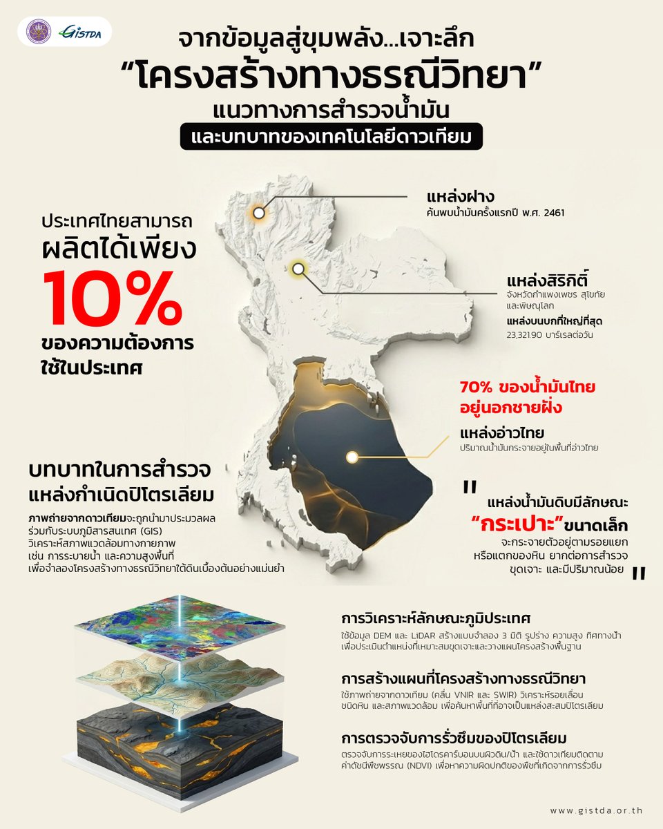


![GISTDA's tweet photo. [2] ช่องแคบมะละกา “ทางเชื่อมโลกตะวันตกและโลกตะวันออก” ตั้งอยู่ทวีปเอเชียบริเวณคาบสมุทรมลายูคั่นระหว่างเกาะสุมาตรา ทำหน้าที่เชื่อมทะเลจีนใต้ มหาสมุทรแปซิฟิกและมหาสมุทรอินเดีย ส่วนที่แคบที่สุดมีความกว้างที่ 2.7 กิโลเมตร อีกทั้งยังเป็นทางผ่านของการขนส่งสินค้าทางทะเลที่มีความสำคัญต่อประเทศไทย ถือเป็นช่องแคบยุทธศาสตร์ด้านภูมิรัฐศาสตร์ รวมถึงด้านเศรษฐกิจของเอเชียตะวันออกและตะวันออกเฉียงใต้ เพราะเป็นเส้นทางที่มีการสัญจรทางทะเลหนาแน่นเป็นอันดับ 2 ของโลก รองรับเรือเกือบ 100,000 ลำต่อปี และเป็นเส้นทางการลำเลียงน้ำมันถึง 35% ของโลก รวมถึงก๊าซธรรมชาติจากกลุ่มประเทศอาหรับ ช่องแคบมะละกามีท่าเรือสำคัญตั้งอยู่หลายแห่ง เช่น ท่าเรือสิงคโปร์ ท่าเรือพอร์ตกลัง และท่าเรือมะละกา และเป็นศูนย์กลางที่เชื่อมตลาดประเทศฝั่งเอเชียเข้ากับยุโรป
.
ช่องแคบบับเอลมันเดบ “ประตูหลังของทะเลแดง” ตั้งอยู่รอยต่อระหว่างทวีปแอฟริกาและเอเชีย คั่นกลางระหว่างประเทศจิบูตี เอริเธีย และเยเมนส่วนที่แคบที่สุดกว้างประมาณ 26 เมตร ทำหน้าที่เชื่อมทะเลเมดิเตอเรเนียน ทะเลแดงออกสู่ทะเลอาหรับผ่านคลองที่ขุดขึ้นอย่างคลองสุเอซ เมื่อมีการขุดคลองสุเอซทำให้ช่องแคบแห่งนี้มีเรือสัญจรมากขึ้น เนื่องจากกลายเป็นประตูกลายเป็นด่านแรกในการขนส่งสินค้าจากทวีปเอเชียสู่ทวีปยุโรป โดยเฉลี่ย 1 วันมีเรือบรรทุกน้ำมันจากกลุ่มประเทศอาหรับประมาณ 6-8 ล้านบาร์เรล รวมถึงสินค้าอื่น ๆ ผ่านช่องแคบนี้ ทำให้ช่องแคบบับเอลมันเดบหากถูกควบคุมคลองสุเอซจะหยุดชะงักโดยทันที
.
คลองสุเอซ “ทางลัดสำคัญของโลก” ตั้งอยู่ประเทศอียิบต์ ซึ่งมีจุดเริ่มต้นที่พอร์ตซาอิตและสิ้นสุดที่พอร์ตสุเอซ ถือเป็นอีกหนึ่งคลองที่ถูกมนุษย์สร้างขึ้น มีความยาว 193.3 กิโลเมตร ซึ่งเป็นคลองขุดโดยมนุษย์ที่ยาวที่สุดในโลก มีความกว้าง 300-350 เมตร โดยขุดครั้งแรกปี 1859 ใช้เวลาขุด 10 ปี ก่อนเปิดให้บริการปี 1869 อยู่ระหว่างทวีปแอฟริกากับเอเชีย ทำหน้าที่เชื่อมมหาสมุทรแอตแลนติกและมหาสมุทรอินเดียผ่านทะเลเมดิเตอร์เรเนียนกับทะเลแดง คลองสุเอซช่วยลดระยะทางจากการอ้อมทวีปแอฟริกาบริเวณแหมกู๊ดโฮปที่เดิมใช้เวลา 8-10 วัน เหลือเพียง 11-16 ชั่วโมง โดยคลองสุเอซรองรับเรือประมาณ 25,000 ลำต่อปี คิดเป็น 12-14% ของการค้าโลก เป็นเส้นทางหลักในการขนส่งน้ำมัน ก๊าซธรรมชาติ รวมถึงสินค้าอุปโภคและบริโภคของทวีปยุโรป
.
คลองปานามา “เส้นเลือดใหญ่แห่งทวีปอเมริกา” ตั้งอยู่บริเวณตอนกลางของประเทศปานามาในอเมริกากลาง ทำหน้าที่เชื่อมมหาสมุทรแอตแลนติกและมหาสมุทรแปซิฟิกฝั่งตะวันออก มีความยาว 82 กิโลเมตร มีความกว้างน้อยที่สุด 91 เมตร โดยขุดครั้งแรกปี 1904 ก่อนแล้วเสร็จปี 1914 คลองปานามาช่วยลดระยะทางอ้อมทวีปอเมริกาใต้บริเวณแหลมฮอร์น เดิมใช้เวลาเกือบ 2 สัปดาห์ เหลือเพียง 10 ชั่วโมง โดยเป็นโครงการที่ท้าทายด้านวิศวกรรม รวมถึงการก่อสร้าง เนื่องด้วยการออกแบบและสร้างประตูกั้นน้ำถึง 12 ประตูเพื่อปรับระดับน้ำสำหรับการเดินเรือที่มีความแตกต่างของ 2 มหาสมุทร ทุกปีคลองปานามารองรับเรือเกือบ 15,000 ลำ สำหรับการขนส่งสินค้า เช่น รถยนต์ และพลังงานธรรมชาติของทวีปอเมริกา
.
เมื่อช่องแคบเหล่านี้คือ “เส้นเลือดใหญ่” ที่หล่อเลี้ยงเศรษฐกิจโลก การดูแลความปลอดภัยของเรือนับแสนลำจึงต้องอาศัยวิสัยทัศน์ที่กว้างไกลกว่าเดิม ปัจจุบันเทคโนโลยีอวกาศจึงเข้ามามีบทบาทสำคัญในการจัดการจราจรทางทะเล
.
ดาวเทียมในปัจจุบันไม่ได้ทำหน้าที่แค่ถ่ายภาพพื้นผิวโลก แต่ยังใช้คลื่นสัญญาณส่งลงมากระทบวัตถุบนผิวน้ำเพื่อสะท้อนกลับ ทำให้เราสามารถติดตามการเคลื่อนไหวและระบุพิกัดของเรือสินค้าต่างๆ ได้แบบ เรียลไทม์ เทคโนโลยีอวกาศจึงเปรียบเสมือน “ดวงตา” ที่คอยสอดส่องและควบคุมความปลอดภัย ยกระดับการสัญจรทางทะเลของโลกให้ราบรื่นและมีประสิทธิภาพมากยิ่งขึ้น
__________
.
The Strait of Malacca, “the Gateway Between East and West” — a vital waterway located in Asia along the Malay Peninsula, separating it from the Indonesian island of Sumatra. The strait serves as a critical connection between the South China Sea, the Pacific Ocean, and the Indian Ocean, with its narrowest point measuring just 2.7 kilometers wide. The waterway holds immense strategic importance — both geopolitically and economically — for East and Southeast Asia, including Thailand, where it serves as a key maritime shipping corridor. It ranks as the second busiest shipping lane in the world, handling nearly 100,000 vessels annually. The strait also carries approximately 35% of the world's oil shipments, along with significant volumes of natural gas from Arab nations. Several major ports are situated along the strait, including the Port of Singapore, Port Klang, and the Port of Malacca, cementing its role as a central hub connecting Asian markets with Europe.
.
The Bab-el-Mandeb Strait, “the Back Door of the Red Sea” — a critical maritime corridor at the intersection of Africa and Asia. Separating Djibouti and Eritrea from Yemen, this narrow passage—spanning roughly 26 kilometers at its tightest point—serves as the indispensable link between the Mediterranean and the Arabian Sea. Since the Suez Canal’s inception, the strait has evolved into a global trade artery, facilitating the daily transit of 6 to 8 million barrels of oil and vast quantities of dry cargo. Its strategic value is absolute: any disruption to the Bab el-Mandeb would effectively paralyze the Suez Canal, severing the primary energy and trade lifeline between Asia and Europe.
.
The Suez Canal, “the World’s Vital Shortcut” — spanning 193.3 kilometers across the Egyptian desert, the Suez Canal remains the world’s longest man-made waterway and a cornerstone of global logistics. Stretching from Port Said to Port Suez, this 350-meter-wide "shortcut" serves as the ultimate bridge between Africa and Asia. By linking the Mediterranean and Red Seas, the canal offers a direct passage between the Atlantic and Indian Oceans, slashing transit times from 10 days—the traditional route via the Cape of Good Hope—to a mere 11 to 16 hours. Today, the canal facilitates 12-14% of global trade, with approximately 25,000 vessels annually hauling essential oil, natural gas, and consumer goods to Western markets.
.
The Panama Canal, “the Lifeblood of the Americas” — serving as the primary maritime artery of the Western Hemisphere, the Panama Canal remains a cornerstone of global trade. Stretching 82 kilometers across Central Panama, this engineering marvel links the Atlantic and Pacific Oceans, effectively bypassing the perilous Cape Horn. By utilizing a sophisticated system of 12 locks to navigate varying water levels, the canal slashes transit times from nearly two weeks to a mere 10 hours. Today, it facilitates the passage of approximately 15,000 vessels annually, funneling essential commodities and automobiles across the globe.
.
As the primary lifelines of the global economy, these straits demand unprecedented oversight. With hundreds of thousands of vessels navigating these narrow corridors, space-based surveillance has shifted from a luxury to a necessity in securing modern maritime traffic.
.
Beyond mere imagery, modern satellites are leveraging advanced signal reflection to track cargo vessels in real-time. This orbital surveillance serves as a digital 'eye' in the sky, optimizing maritime traffic flow and bolstering global supply chain security.
.
#GISTDA #อว
#ช่องแคบ #ภาพถ่ายดาวเทียม](https://pbs.twimg.com/media/HEYa5Txa8AANUU5.jpg)
![GISTDA's tweet photo. [1] รอยต่อทางภูมิประเทศ: จาก “ช่องแคบ”' ธรรมชาติ สู่เส้นเลือดใหญ่ทางภูมิศาสตร์ที่เชื่อมโลก สำรวจ 6 ช่องแคบสำคัญผ่านดวงตาจากอวกาศ
.
ช่องแคบเป็นเหมือน "เส้นเลือดใหญ่" การค้าโลก แม้จะเป็นเพียงพื้นที่เส้นทางน้ำ แต่ความสำคัญของมันนั้นมหาศาลทั้งในเชิงเศรษฐกิจ การเมืองและความมั่นคง เป็นทางลัดช่วยลดระยะเวลาประหยัดต้นทุนพลังงานการขนส่ง เป็นต้น ถือเป็นหนึ่งเครื่องมือทางภูมิศาสตร์ที่ถูกสร้างโดยธรรมชาติ แต่เป็นกลไกควบคุมทางเศรษฐกิจของทั้งโลกได้ เนื่องจากเป็นเส้นทางเชื่อมโลกมาตั้งแต่อดีตจนถึงปัจจุบัน
.
ช่องแคบ (Strait) “สเตรท” ลักษณะภูมิประเทศที่เป็นพื้นที่ทางทะเลทอดอยู่ระหว่าง 2 พื้นทวีปหรือเกาะ โดยในบางแห่งช่องแคบเป็นจุดเชื่อมรอยต่อของมหาสมุทร สาเหตุนี้ทำให้ช่องแคบเป็นพื้นที่ทรงอิทธิพลต่อภูมิรัฐศาสตร์ของโลก เพราะมีผลต่อปัจจัยเชิงพื้นที่ อีกทั้งได้รับปัจจัยจากมนุษย์ที่กำหนดนโยบายทางทะเล การสัญจรทางทะเลมีมาตั้งแต่อดีตเพราะเรือสามารถบรรทุกสิ่งของได้มากทั้งสินค้าอุปโภค บริโภค รวมถึงพลังงานธรรมชาติ เช่น น้ำมัน ก๊าซธรรมชาติ และแร่ธาตุสำคัญต่างๆ ในภาคอุตสาหกรรม เป็นต้น วันนี้แอดมินจะพาไปสำรวจ 6 ช่องแคบสำคัญผ่านดวงตาจากอวกาศ ซึ่งถือเป็นยุทธศาสตร์ที่สำคัญของโลกกันครับ
.
ช่องแคบฮอร์มุซ “ประตูน้ำมันจากตะวันออกกลาง” ตั้งอยู่ทวีปเอเชียคั่นระหว่างแหลมมุซันดัม ประเทศโอมาน สหรัฐอาหรับเอมิเรตส์ และอิร่าน ทำหน้าที่เชื่อมอ่าวเปอร์เซีย และอ่าวโอมานกว้างประมาณ 39 กิโลเมตรเป็นทางออกสู่มหาสมุทรอินเดียทางเดียวของกลุ่มประเทศผู้ค้าน้ำมันในเอเชียตะวันตกเฉียงใต้ (ตะวันออกกลาง) โดยเฉลี่ย 1 วันมีเรือบรรทุกน้ำมันประมาณ 17 ล้านบาร์เรล คิดเป็น 20% ของปริมาณน้ำมันโลก ยังมีการส่งออกก๊าซธรรมชาติเหลว คิดเป็น 1 ใน 4 ของโลกทำให้ช่องแคบฮอร์มุซมีผลต่อความมั่นคงด้านพลังงาน โดยเฉพาะประเทศที่พึ่งพาพลังงานจากกลุ่มประเทศอาหรับ ในทวีปเอเชียจะได้รับผลกระทบโดยตรง และประเทศไทยเองพึ่งพาน้ำมันกว่า 50% ทั้งนี้ ด้วยสถานการณ์ในปัจจุบันได้สร้างผลกระทบต่อเศรษฐกิจไทยทำให้ต้นทุนด้านพลังงานสูงขึ้นจากการขนส่งทางทะเล
.
ช่องแคบอังกฤษ “ประตูตะวันตกของทวีปยุโรป” ตั้งอยู่ทวีปยุโรปคั่นระหว่างประเทศอังกฤษ และประเทศฝรั่งเศส ทำหน้าที่เชื่อมต่อทะเลเหนือและมหาสมุทรแอตแลนติก อีกทั้งเป็นเส้นทางเชื่อมเกาะบริเตนใหญ่และแผ่นดินใหญ่ของยุโรป ส่วนที่แคบที่สุดอยู่บริเวณช่องแคบโดเวอร์มีความกว้างที่ 34 กิโลเมตร ช่องแคบอังกฤษมีความสำคัญมาตั้งแต่อดีต เป็นเส้นทางเชื่อมต่อไปยังอเมริกาผ่านมหาสมุทรแอตแลนติก ปัจจุบันถือเป็นช่องแคบที่มีเรือสัญจรมากที่สุดในโลก รองรับเรือประมาณ 500 ลำต่อวัน โดยการสัญจรในบริเวณนี้ต้องอาศัยความชำนาญ รวมถึงความระมัดระวังเพราะสภาพอากาศที่แปรปรวน คลื่นลมแรง และแรงดันน้ำสูง มีผลมาจากภูมิประเทศที่ตั้งอยู่ในมหาสมุทรแอตแลนติกประกอบกับกระแสน้ำอุ่นก่อให้เกิดความชื้น รวมถึงลมตะวันตกทำให้เกิดฝน อีกทั้งชายฝั่งยุโรปบริเวณช่องแคบอังกฤษถือเป็นแหล่งเพาะปลูกที่สำคัญ
__________
Geographic Arteries: A Satellite Perspective on the Six Straits That Define Global Commerce.
.
From natural straits to vital arteries of global trade, these geographical junctions connect the world. This study examines six significant straits from a space-based perspective.
.
Far more than mere waterways, the world’s primary straits function as the indispensable arteries of global commerce. These natural conduits serve as high-stakes geopolitical levers, offering critical shortcuts that drastically reduce transit times and fuel consumption. While carved by nature, they operate as a man-made mechanism for economic dominance, remaining the most vital links in the global supply chain from antiquity to the modern era.
.
A strait is a vital geographical feature — a narrow body of water that lies between two continents or islands. In many cases, straits serve as critical links between major oceans, elevating their importance in global geopolitics. These waterways shape not only physical geography but also maritime policies driven by human activity. Maritime navigation has existed since ancient times, as ships offer an efficient means of transporting large volumes of goods—from everyday consumer products to natural resources such as oil, natural gas, and essential industrial minerals. Today, we explore six of the world’s most strategically significant straits through a space-based perspective, revealing their crucial role in shaping global trade, security, and connectivity.
.
The Strait of Hormuz, “The Strategic Maritime Gateways” — Situated between the rugged cliffs of Oman’s Cape Musandam and the Iranian coastline, the Strait of Hormuz remains the world’s most sensitive maritime artery. As the sole exit for Persian Gulf crude, this narrow passage facilitates the transit of 17 million barrels daily—accounting for 20% of global oil supply and a quarter of worldwide LNG exports. For energy-dependent nations like Thailand, which relies on the Middle East for over 50% of its oil, the strait is more than a geographic landmark; it is a critical vulnerability. Current regional tensions are already manifesting in the Thai economy through surging logistics costs and heightened energy inflation.
.
The English Channel, “the Western Gateway of Europe” — located in Europe, serves as a natural boundary separating England and France. It connects the North Sea with the Atlantic Ocean and functions as a key maritime route linking Great Britain to the European mainland. Its narrowest point, the Dover Strait, spans just 34 kilometers wide. Historically, the English Channel has played a significant role as a gateway to the Americas via the Atlantic Ocean. Today, it holds the title of the world's busiest strait, handling approximately 500 vessels per day. However, navigation through this waterway demands considerable skill and caution. Mariners must contend with unpredictable weather conditions, strong winds, and powerful water currents — challenges that stem from its position in the Atlantic Ocean, where warm ocean currents bring high humidity and prevailing westerly winds generate frequent rainfall. Beyond its maritime significance, the European coastline along the English Channel is also recognized as a vital agricultural region, contributing to the economic importance of the area on both sides of the strait.
.
#GISTDA #อว
#ช่องแคบ #ภาพถ่ายดาวเทียม](https://pbs.twimg.com/media/HEYaQ_7aoAAPx8s.jpg)


