Hüseyin Topan, Onur Erişik, Murat Oruç, TUFUAB Veri Havuzuna Ait Göktürk-1 Bindirmeli Pankromatik Seviye 2A Görüntülerinin Algılayıcıya Bağımlı Yöneltme Yöntemi İle 3B Konum Doğruluğunun Araştırılması, TUFUAB XIII. Teknik Semp., Zonguldak, 18-20.06.2025.
https://t.co/f02jbFIHQ6
It is time to publish Geo3o1 v.6, a Matlab tool for georeferencing accuracy assessment of optical tri-stereo images using their state-of-the-art sensor dependent orientation models of Pléiades 1A/1B and Göktürk-1.
https://t.co/LIa31m7rqf
Yeni makale/new article: Hüseyin Topan (@htopan), First experience of 3D georeferencing accuracy assessment of SPOT 6 stereo panchromatic primary images by sensor-dependent orientation model, Remote Sensing Letters, 14(12): 1294-1302, https://t.co/SNACnA8gZb
Today is the 14th birthday of GeoSpot, created by @htopan. GeoSpot is the premise of Geo3o1, the state of the art sensor dependent orientation model. So far, GeoSpot&Geo3o1 have been used to analyse SPOT 5/6 6, Pléiades 1A & Göktürk 1 pan stereo/triplet images. To be continued😉
The name, motto and logo of GeoEtrim (GeoEtrim, geospatially yours) have been registered by the Turkish Patent and Trademark Office under the number of 2022 208339 in 23rd June 2023.
Dear community, I have modified @GeoEtrim's Geo3o1 tool for SPOT 6/7 and can be used for Pléiades Neo. If you have those satellite's stereo image(s) in primary (sensor) level, and points with ±~1/3-1/5 GSD accuracy, we can evaluate them wrt 3D georeferencing accuracy.
The https://t.co/j5x0ngNBtf file has been added into the https://t.co/8HCuMeep2W C# version's repository. If you have problem about importing the GDAL library while setting up the software, please watch this video: https://t.co/dFBKVJd24c
The full text of "Topan, H., Cam, A., Erdoğan, B., Görmüş, K.S., Pléiades 1A Pankromatik Üçlü Bindirmeli Şerit Görüntülerinin 3B Konum Doğruluğunun Algılayıcıya Bağımlı Yöneltme Yöntemi İle Değerlendirilmesi", VIII. @uzalcbs 2022 is available by https://t.co/ilxmebgsQr
It's suprising me to see this cover of JARS. It was a long-term period research since 2014, and it is pretty that one of it's iconic figure covering Zonguldak and Karadeniz with GCP/ICPs was selected as cover image. Thanks to the editor-in-chief and the staff. @SPIEtweets
Yeni makale: Hüseyin Topan "Geo3o1: a tool for 3D georeferencing accuracy assessment of tri-stereo images by state-of-the-art sensor dependent orientation model," Journal of Applied Remote Sensing 16(4), 047502 (14 November 2022). https://t.co/T67BG5juVl
As a non-profit organisation, https://t.co/SyF8ym67gp will not serve because of the financial difficulties. New web site will be announced as soon as possible. The users can reach the tools via https://t.co/8HCuMeep2W.
@ekremgecici, @htopan, GeoEtrim Qt&C++ 2021 Sürümüne Temel Özelliklerin Kazandırılması, TMMOB Harita ve Kadastro Mühendisleri Odası, 18. Türkiye Harita Bilimsel ve Teknik Kurultayı, 26-29 Mayıs 2021, Ankara.
✏️https://t.co/AFpVt7uEtr
📺https://t.co/BgWhPKT0QI
14 yıl olmuş @TMMOBHKMO Türkiye Harita Bilimsel ve Teknik Kurultayına bildiri gönder(e)meyeli... Bu sene nasip oldu, umarım sonrakilere de en az bir bildiri ile katılabilirim. YL öğrencim @ekremgecici'nin tezinin bir bölümünü içeren sunumumuza bekleriz. https://t.co/fdf5KwXxfE
GeoEtrim's #cplusplus project in @Qtproject has been updated (https://t.co/RZPUebrTox), thanks to @ekremgecici, @SametDO61352143 and Osman Semih Eyimaya. Now, we strive to import #GDAL library for image reading. Contributions are welcome to this #opensource project.🤗
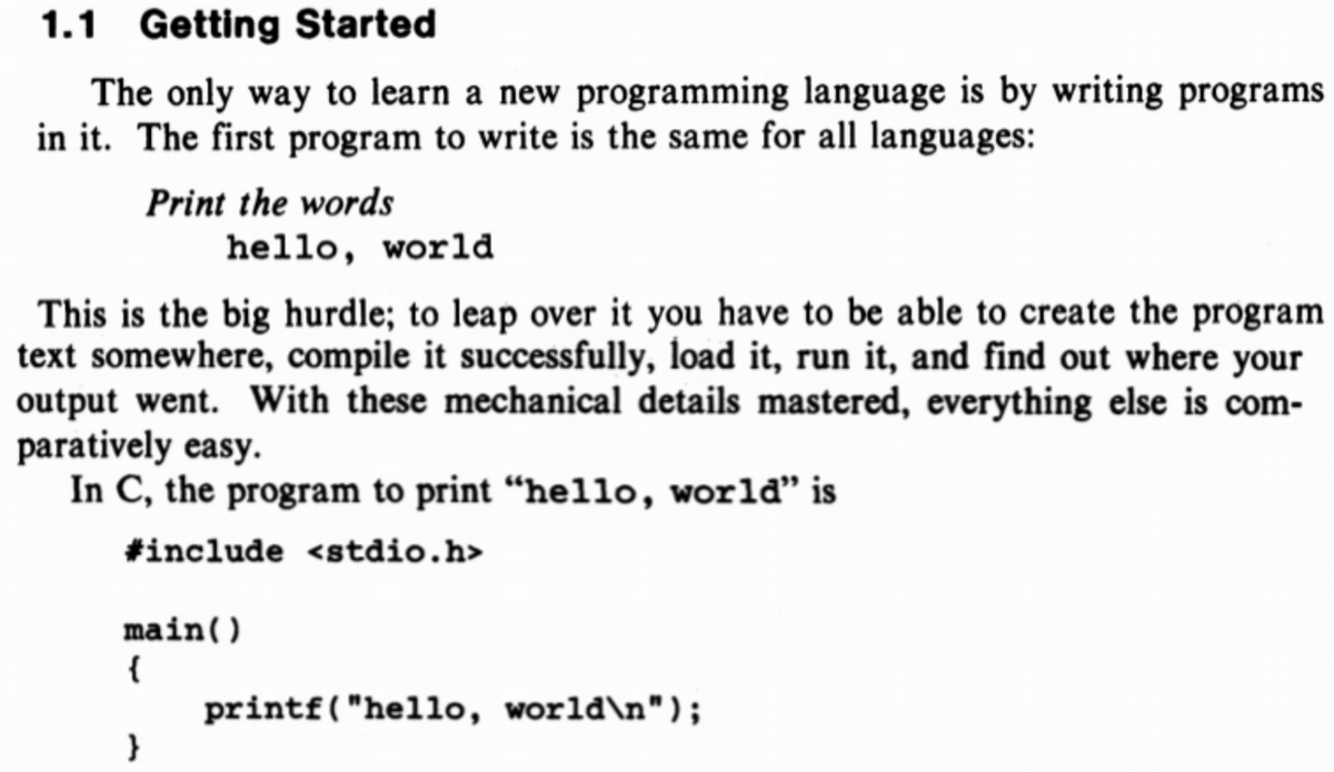
Today’s the day that “hello world” said “hello world!”
The term was coined in a textbook published #otd in 1978: “C Programming Language,” written by Brian Kernighan and Dennis Ritchie.
https://t.co/1Lv0pyEho2
#tdih#helloworld