Love to see powerful visuals built on top of GeoTrellis. Especially examples that leverage the expertise of several great companies and organizations.
@orbital_insight@openstreetmap @planetlabs
We partnered with @orbital_insight to compare building coverage in OpenStreetMap with data they extracted from @planetlabs imagery in cities around Cambodia. Pretty nifty tool you can play with here: https://t.co/aD6X0H5NiD.
More at Orbital's blog here: https://t.co/1ELwhO6sQQ
We are excited to see a closer integration between GeoTrellis and @databricks.
Check out the blog DB just published: https://t.co/XGEl3MJsvY
We are working together to make it easier to get started with GeoTrellis and the ecosystem of big data geo tools leveraging @ApacheSpark
🎉Very excited to announce the release of GeoTrellis 3.0 🎉
We are focused on making it easier to work with Cloud Optimized GeoTIFFs (#cogs) and are working towards closer #STAC integration.
Read about the changes here:
https://t.co/RTAllBr6r5
Let us know what you think!
I'm sure every industry has powerful people behind the scenes making things happen, but holy cow @opencholmes is on another level. @USGS announced they're going to be publishing Landsat data in STAC & COGs! h/t @mcraddock for tipping me off. https://t.co/ndAb10b5Zl
Thanks for getting these videos up so quickly! And thanks again to all of the organizers. It was a great conference.
Two GeoTrellis related talks from State of the Map US:
https://t.co/H4YfppTv58
https://t.co/3U7N5uz1vx
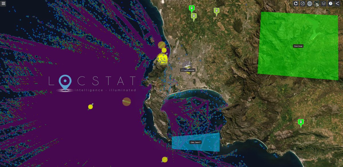
The context that #location brings to a data-set is essential to get rich insights. Locstat ('Location Status'😉) brings together Graph, Event & #Geospatial Processing into our solutions. Here is a screenshot of Locstat's 'Common Operating Picture' interface. @CesiumJS@geotrellis
Just got two speaker tickets for @sotmus. @echeipesh and @rosszb will both be presenting @azavea's work with @openstreetmap: including #vectortile analysis & generation and expanding our work with #SDG 9.1.1 Looking forward to seeing some of yall there!
https://t.co/fqAYwbWPRZ
Love to share job postings that mention GeoTrellis. This one seems great:
https://t.co/WZm6FkDVMp
> The applicant will [...] develop interoperable geospatial decision support platforms for smart city energy applications as well as environmental crisis and disaster management
@MykolaKozyr@mouthofmorrison@azavea@bingmaps@openstreetmap@jharpster @MapOfTheWeek Bing does have tons of buildings in Austin. It's just in purple, so that means its in both Bing and OSM.
And it was mentioned on the main thread that there is a ring around many metro areas because there is higher resolution imagery available, and that is the interstitial zone.
Yooo big news! @azavea just published a countrywide comparison of @bingmaps 100M building footprint dataset with an extract of all of @openstreetmap's data for the U.S. Thanks to @jharpster and the team that open sourced this data! Go have fun with it: https://t.co/KRizO9l1pY.
This visualization and analysis was made possible because of open source; open tools, open data.
With special shoutout to @Mapbox
https://t.co/Lerz6GVieu
https://t.co/PNkVgtg3uB
https://t.co/RlGPzRlRF3
#GIS#opensource#vectortiles
Last year, @bingmaps released 125 million U.S. building footprints derived from #MachineLearning models. @openstreetmap currently has about 38 million buildings in the U.S.. Check out this visualization from our @geotrellis team to see how they compare https://t.co/r6pJRfPVw4
Pleased to announce support for #wms and #wcs in GeoTrellis + @rasterfoundry.
Tested, reliable standards are essential for geospatial interoperability.
Thank you @nrcan for supporting the effort, it'd been on the roadmap for too long!
https://t.co/3VAFdBboK8
@opengeospatial
Exciting to see this develop, glad that @azavea was able to support and could send a couple folks from the @rasterfoundry team to contribute. James S built a quick prototype tms viewer for STAC items with geotrellis server.