Things that flat earthers deny or hand wave away as faked that conclusively falsify a flat non rotating flat earth with a firmament.
1. Foucault Pendulums proves the earth is rotating.
The plane of oscillation of the pendulum rotates at a rate depending on latitude (15°/hour × sin(latitude)).
At the poles it completes a full circle in approximately 24 hours; at the equator, zero.
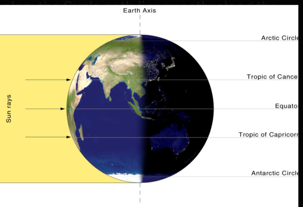
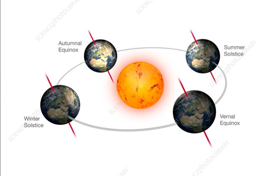
2. 24 hrs of a visible sun at the South and North Poles at the equinox simultaneously, rotating in opposite directions.
At the equinoxes, the Sun circles the horizon at both poles but in opposite directions.
A flat Earth sun circling above a disk cannot produce opposite apparent rotations plus simultaneous 24 hrs of a visible sun at both the edges (ice wall) and the middle (north pole) at the same time.
3. 24 hrs of sun in Antarctica for the entire summer, equal and opposite to the 24 hrs of sun in the Arctic region for their entire summer.
4. Circumpolar stars which are different stars in the south compared to the north.
Sigma Octantis / Southern Cross never visible from far north of the equator, Polaris never visible from far south of the equator.
5. The Moon appears flipped in the south compared to the north.
In the Southern Hemisphere the Moon appears "upside down" relative to Northern views, and the terminator (day/night line) tilts the opposite way.
Consistent with a globe, flat earth tries to explain it by saying the moon is a projection from a movie studio on earth where the firmament is the screen.
6. Photographs from outer space of the shape of the earth. If it was flat, we would see it very clearly, but we don't.
7. Circumnavigation of Antarctica, world record races.
Multiple independent voyages and races (yacht races) have sailed around Antarctica in reasonable times/distances (10,000–15,000+ nautical miles depending on route), not the 50,000+ km "ice wall" perimeter required by some flat models.
Flat Earthers dismiss these as faked.
8. Longer daylight hours the further you head south during summer in the southern hemisphere, totally impossible if the sun is rotating always away from the south.
Example Tasmania has longer daylight hours than Queensland.
9. Airplane flight paths and great circle routes.
Sydney–Santiago routes fly south near Antarctica (not straight across a flat map's vast southern ocean) so that the distance travelled is actually less, less surface area the more south you travel.
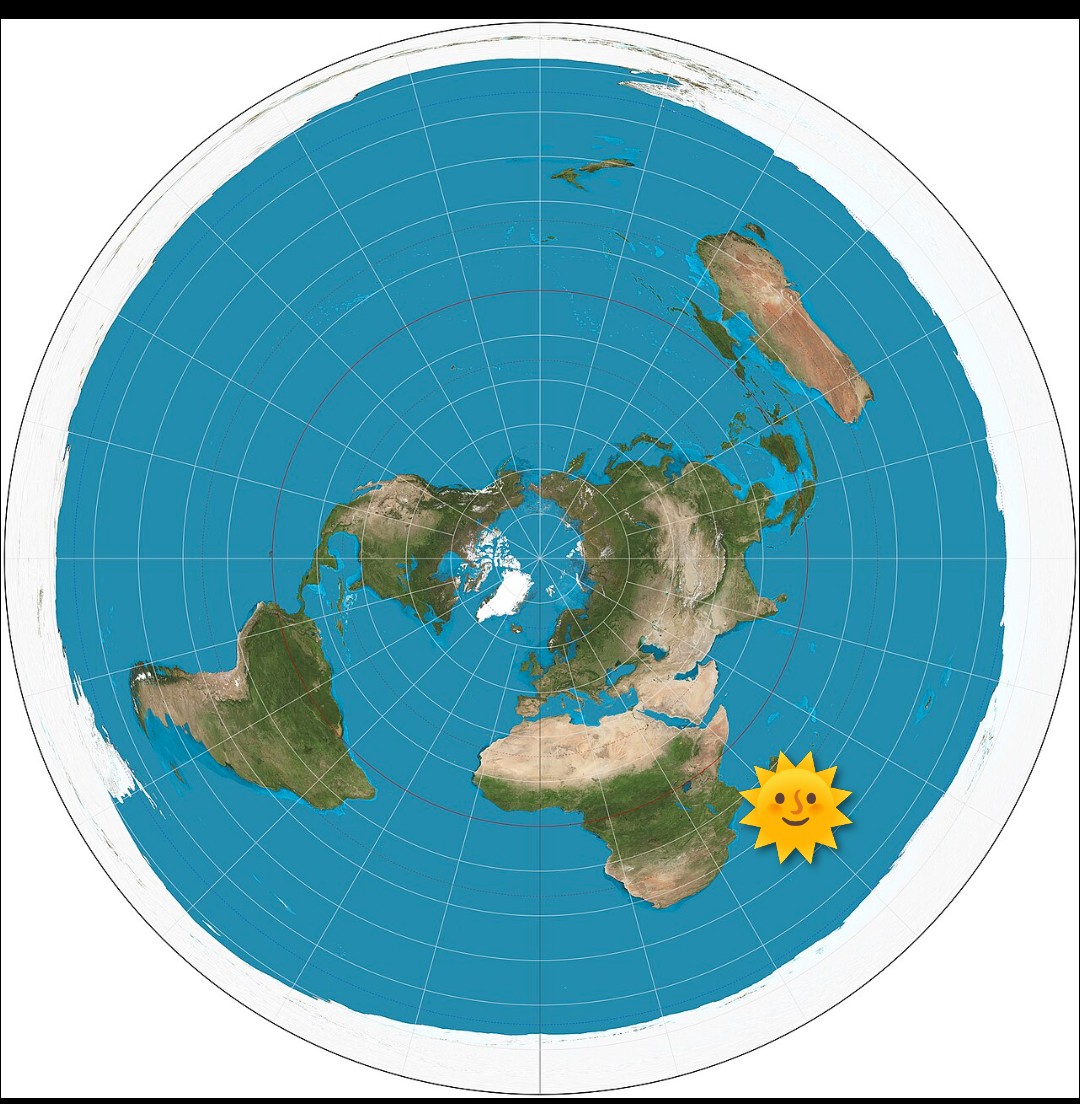
10. Distance measurements from the north pole to the equator do not match any radius of a circle measurements, falsifying any chance it's a flat plane.
Measured great circle distance approximately 10,000 km from the north pole to the equator.
On any flat disk model with the centre at the North Pole, the circumference at the equator would be 2π × radius = approximately 62,800 km.
But actual equatorial circumference is appropriately = 40,000 km, falsifying any flat earth circular map.
It's a globe, always was and always will be.
@butthurt1313 https://t.co/b8p9kDOVpp
Water isn't horizontal.
If it's horizontal you'd be able to see this bright rocket plume.
But we can't until it crosses the geometric horizon.
@did8hurtu That's funny, a guy posting stuff who has no idea how a vanishing point works and can't explain why there's more daylight hours the further you travel away from the Tropic of Capricorn towards the south.
https://t.co/Dk1xexSXh0
In the Australian Summer at the summer solstice, this is the sunrise and sunset times from December 22nd, 2025 in the cities of Ayr, Queensland and Launceston, Tasmania.
As you can see the longitude lines are virtually identical. However latitude is about 22 degrees apart.
Launceston, Tasmania (~41.4°S, 147.1°E)
Sunrise: 5:34 AM
Sunset: 8:45 PM
Daylight length: 15 hours, 10 minutes, 51 seconds
Ayr, Queensland (~19.6°S, 147.4°E)
Sunrise: 5:29 AM
Sunset: 6:48 PM
Daylight length: 13 hours, 19 minutes, 2 seconds
Ayr is closer to the tropic of Capricorn, that is the line where at noon the sun would be directly above you if your location is on that line.
At this sunset time, the actual sun solar noon position is above Madagascar.
The question for flat earthers is how is it possible to actually see the sun for longer when those people living in Launceston, Tasmania are further away from the sun.
Flat earthers believe that the reason the sun sets is because it has a vanishing point based on perspective.
So explain why it is that those that are closer to the sun lose sight of it earlier than those that are further away?
It gets better than that, at the equinox the actual sun is visible from the geographical south pole and the geographical north pole, simultaneously for a few days, and it's above the horizon for 24hrs from both locations.
Impossible on a flat map without illuminating everything, everywhere.
@BruisedFerret@selbsman1 You're assuming flat and doing basic trigonometry to measure what the angle is for A and then comparing to actual observations taken B? Result being B in reality?
In the Australian Summer at the summer solstice, this is the sunrise and sunset times from December 22nd, 2025 in the cities of Ayr, Queensland and Launceston, Tasmania.
As you can see the longitude lines are virtually identical. However latitude is about 22 degrees apart.
Launceston, Tasmania (~41.4°S, 147.1°E)
Sunrise: 5:34 AM
Sunset: 8:45 PM
Daylight length: 15 hours, 10 minutes, 51 seconds
Ayr, Queensland (~19.6°S, 147.4°E)
Sunrise: 5:29 AM
Sunset: 6:48 PM
Daylight length: 13 hours, 19 minutes, 2 seconds
Ayr is closer to the tropic of Capricorn, that is the line where at noon the sun would be directly above you if your location is on that line.
At this sunset time, the actual sun solar noon position is above Madagascar.
The question for flat earthers is how is it possible to actually see the sun for longer when those people living in Launceston, Tasmania are further away from the sun.
Flat earthers believe that the reason the sun sets is because it has a vanishing point based on perspective.
So explain why it is that those that are closer to the sun lose sight of it earlier than those that are further away?
Geographic south pole filmed at the equinox in March.
Things to note, the sun elevation above the horizontal doesn't dip below the horizon and height above the horizontal doesn't change.
This is only possible on a spinning ball when you are right at the bottom or at the top of the ball.
If you were watching this on a flat plane, this would work ok if you were at the centre of the disc, but on the edge of the disc, not a chance.
In the Australian Summer at the summer solstice, this is the sunrise and sunset times from December 22nd, 2025 in the cities of Ayr, Queensland and Launceston, Tasmania.
As you can see the longitude lines are virtually identical. However latitude is about 22 degrees apart.
Launceston, Tasmania (~41.4°S, 147.1°E)
Sunrise: 5:34 AM
Sunset: 8:45 PM
Daylight length: 15 hours, 10 minutes, 51 seconds
Ayr, Queensland (~19.6°S, 147.4°E)
Sunrise: 5:29 AM
Sunset: 6:48 PM
Daylight length: 13 hours, 19 minutes, 2 seconds
Ayr is closer to the tropic of Capricorn, that is the line where at noon the sun would be directly above you if your location is on that line.
At this sunset time, the actual sun solar noon position is above Madagascar.
The question for flat earthers is how is it possible to actually see the sun for longer when those people living in Launceston, Tasmania are further away from the sun.
Flat earthers believe that the reason the sun sets is because it has a vanishing point based on perspective.
So explain why it is that those that are closer to the sun lose sight of it earlier than those that are further away?
@benwehrman You do realise that in the Australian summer, the states closest to the south on the same longitude, see the actual sun longer than those closer to the tropic of Capricorn?
How do you explain that with your fantasy map of the world.