When #Kirk reaches Europe it will no longer be a hurricane, but the storm could still bring strong winds to parts of Spain, Portugal, France, Belgium, and the UK next week.
This map shows the latest ICON wind gusts forecast plus the latest forecast path from the NHC:
Major Hurricane #Kirk (cat 4) is now in the Atlantic. It will continue moving towards Europe. 🧐 By mid-week, it is expected to weaken into a post-tropical storm and reach France (see wind gust map for the next 5 days).
We are back Geographers! Year 11 are about to study Hurricanes just as two make landfall in North America at the same time last Thursday! Impacts so far include a burst dam causing even more catastrophic flooding. Our thoughts and prayers are with all affected 🙏🏼
Mind blowing to see two hurricanes, #HurricaneJohn on the left (west coast of Mexico), and #HurricaneHelene (Big Bend region of Florida) on the right, both making landfall at nearly the same time. #Helene#John
One of our A Level students is investigating the Impacts of the New Sea Wall development in West Kirby. Can you spend a few minutes to give your views?
Anonymous responses and only used in coursework. Thanks https://t.co/NkDUjyBVuM
One of our A Level students is investigating public opinion of the coastal management along #Hoylake Beach. We would be grateful if you could take a few minutes to respond to this https://t.co/FdOBrJdRi9
All responses are anonymous and will only be used for the investigation.
One of our A Level students is investigating public opinion of the coastal management along #Hoylake Beach. We would be grateful if you could take a few minutes to respond to this https://t.co/FdOBrJdRi9
All responses are anonymous and will only be used for the investigation.
The northern Noto Peninsula has seen some incredible uplift following the January 1st M7.6 earthquake.
Japan in total gained 4km² of new landmass.
4m of uplift which dried up 15 ports.
Beaches have widened by up to 250m seaward in Wajima!
📹 ANNnewsCH
One of our A Level students is investigating the Impacts of the New Sea Wall development in West Kirby. Can you spend a few minutes to give your views?
Anonymous responses and only used in coursework. Thanks https://t.co/NkDUjyBVuM
A strong northerly wind means it will feel a lot colder than temperatures suggest on Monday, especially along northern and eastern coasts ❄️
How cold will it feel out there for you tomorrow? 📉
SNOW LEOPARD POSTER COMPETITION! 🐆
TWO majestic snow leopards are set to make their new home at the zoo this spring, and YOUR artwork could be featured alongside them! 😍
We want you to create a spectacular snow leopard poster that inspires people to take action on climate change. Draw or paint a snow leopard (or leopards!) and select one of the pledges listed below to add to your poster.
Exciting prizes await...
- Your poster showcased in our NEW snow leopard habitat and featured in Nat Geo Kids magazine!
- A trip for you and your family to Chester Zoo.
- £50 to enjoy food and beverages at the zoo.
- Adorable snow leopard plush toys!
Hurry, you only have until February 10, 2024! Click the link in the comments for all the details on how to take part! 👇
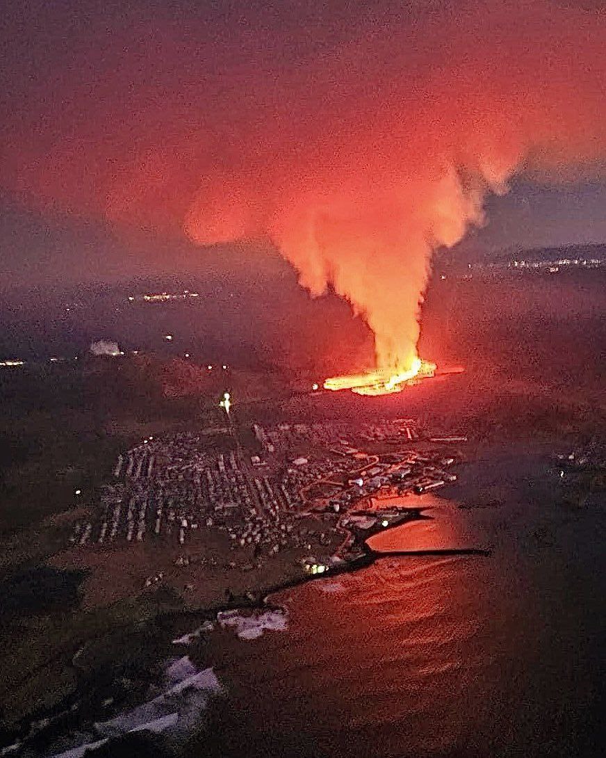
Eruption in #Iceland: Summary of Informaiton I've gathered so far....
🔸 Grindavík was evacuated around 3 am, two days ahead of the scheduled deadline, due to significant seismic and magmatic activity, ensuring the town was fully evacuated before the eruption began.
🔸 The Blue Lagoon hotel also evacuated its activity areas, with successful execution, as confirmed by Helga Árnadóttir, the manager of sales, operations, and services at the attraction, noting minimal occupancy in the hotel.
🔸 Residents, awakened by sirens, left their homes promptly during the evacuation, facing inconveniences and expressing exhaustion from the continuous seismic events.
🔸 The Icelandic Met Office issued warnings based on seismic activity, indicating the likelihood of an imminent lava eruption, supported by data showing changes in pressure and real-time GPS station readings.
🔸 The eruption, though smaller than the previous one, prompted the evacuation of Grindavík, showcasing the proactive approach of authorities in decision-making.
🔸 The lava, flowing towards Grindavík, was approximately 450 meters from the town's northernmost houses, according to the Icelandic Meteorological Office.
🔸 A plea was made to sightseers to refrain from approaching the eruption site, allowing authorities to focus on mitigating potential damage and saving critical resources.
🔸 The lava is dangerously close to consuming a building, identified as a greenhouse run by the company ORF biotechnique, visible on RÚV's webcams.
🔸 Volcanologist Ármann Höskuldsson expressed hope for a short eruption but noted similarities with the previous one, anticipating potential recurrence for the next ten to twelve years.
🔸 Anti-lava defenses north of Grindavík were under construction, with the first phase well advanced, though not yet reaching their full size, emphasizing the ongoing efforts to mitigate potential damage.
Photo: Coast Guard
https://t.co/gsg8Estld2