Flood Advisory extended from 6/14/2026 9:08 AM to 10:00 AM CDT for Grayson County, TX.
IMPACTS: Minor flooding in low-lying and poor drainage areas.
ADDITIONAL DETAILS:
While the heaviest rain has exited to the southeast, lingering rain over the next hour or two may exacerbate any current or imminent minor flooding in the advisory area. Between 1 and 2 inches of rain have fallen so far.
Additional rainfall amounts up to 1 inch are expected over the area. This additional rain will result in minor flooding.
Image depicts radar coverage of rain over Grayson county and flood advisory area.
The best defense is a good offense!
Before you leave for an outdoor event, check the forecast at https://t.co/UhFgw9iswF. Hazardous weather can change your plans in an instant, so stay informed and be ready to pivot. #dfwwx#txwx
Flood Advisory from 6/14/2026 7:19 AM to 9:15 AM CDT for Grayson County, TX.
IMPACTS: Minor flooding in low-lying and poor drainage areas.
Minor flooding is ongoing or expected to begin shortly in the advisory area. Between 1 and 2 inches of rain have fallen.
Additional rainfall amounts of 1 to 2 inches are expected over the area. This additional rain will result in minor flooding.
Image depicts rainfall radar over Grayson county and extent of flood advisory.
☔️Heavy Rain expected Today (06/14) and tomorrow (06/15)☔️
Rain chances continue today as scattered showers and storms gradually shift southward along a passing cold front this morning into this afternoon. Strong wind gusts, as well as occasional lightning and heavy rain (flash flooding) will be the main threats!
Storm chances continue on Monday with locally heavy rain, frequent lightning, and gusty winds as the main hazards during this time.
Stay weather aware. Never try and cross flooded roads. Have multiple ways to receive warnings.
Images depict rain chances for Sunday (today), Monday, and this weeks forecast.
Diminishing thunderstorms northwest of the Metroplex this morning will lend way to mostly sunny skies this afternoon. Heat indices are expected to remain below advisory criteria, but may still reach 100 - 105 degrees during the afternoon. Continue to take heat precautions! #dfwwx
☀️Weekend Weather Update 06/13-06/14☀️
Heat index values today (Saturday) should remain below advisory criteria, but may still reach 100 to 105 degrees during the afternoon. Take heat precautions if spending time outdoors.
Rain chances return on Sunday as scattered showers and storms are expected to form along a passing cold front. Strong wind gusts, as well as occasional lightning are the main hazards.
Stay weather aware. Take breaks from the heat, stay hydrated, wear sunscreen.
Images depict high temperatures on Saturday, heat safety tips, and rain chances on Sunday.
Flood Advisory from 6/12/2026 11:38 AM to 1:30 PM CDT for Grayson County, TX.
IMPACTS: Minor flooding in low-lying and poor drainage areas.
Minor flooding is ongoing or expected to begin shortly in the advisory area. Between 1 and 2 inches of rain have fallen.
Additional rainfall amounts of 1 to 2 inches are expected over the area. This additional rain will result in minor flooding.
Image depicts radar coverage of storms over Grayson County.
☔️Upcoming Storms June 12-14☔️
Scattered storms are possible from this morning into the afternoon, some of which may produce frequent lightning and strong downburst wind gusts.
On Saturday we could see afternoon heat index values between 99 and 105 degrees. Stay hydrated, take frequent breaks, and limiting strenuous activity during outside activities.
Rain and thunderstorm chances will increase Sunday into Monday as a cold front moves into the area. Some storms could produce strong downburst wind gusts and frequent lightning, along with locally heavy rainfall and flooding.
Images depict storm chances on Friday, heat risk on Saturday, and storm chances on Sunday.
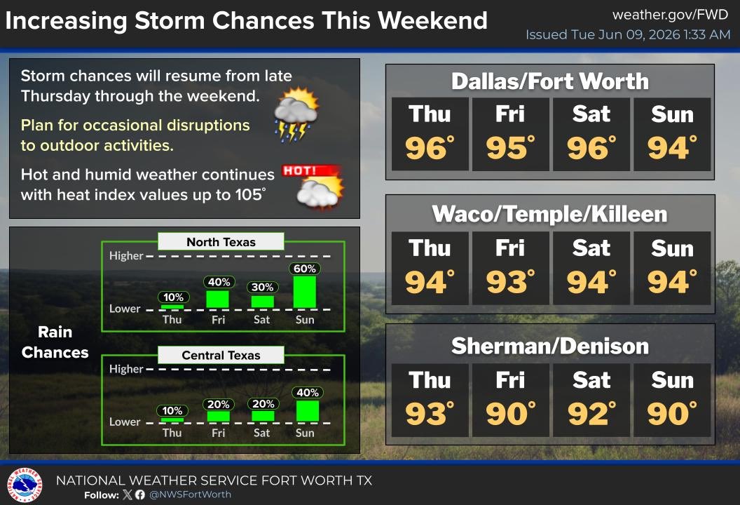
Rain chances will increase across North and Central Texas Sunday into Monday as a cold front moves through. Some storms could produce strong wind gusts, frequent lightning, and heavy rain. Plan for disruptions to outdoor activities due to nearby storms during this time period.
🌡️Heat index values will climb to hazardous levels across parts of Texas.
💧Stay hydrated
☀️Limit outdoor activity during peak heat
👕Wear light clothing
👥Check on vulnerable neighbors
Find more heat safety tips: https://t.co/1QXhc6kZrx
#txwx
🚧Traffic Alert Grayson County🚧
Upcoming nightly full closure of the US 75 SB mainlanes beginning at 8 p.m. until 5 a.m. on June 15 until June 16.
The US 75 SB motorists will be detoured at Exit 65, SB exit to Loy Lake Road, Sherman. Motorist will follow the marked detour.
🚧Traffic Alert Grayson County🚧
Upcoming nightly full closure of the US 75 SB frontage road beginning at 8 p.m. until 5 a.m. on June 12 until June 13.
The US 75 SB frontage road motorists will be detoured at Cornerstone Drive. Motorists will follow the marked detour.
🚧Traffic Alert Grayson County🚧
Upcoming nightly full closure of the US 75 NB frontage road beginning at 8 p.m. until 5 a.m. on June 11 until June 12.
The US 75 NB frontage road motorists will be detoured at Taylor Street. Motorists will follow the marked detour.
🚧Traffic Alert Grayson County🚧
Nightly full closure of the US 82 WB frontage roads beginning at 6 p.m. on the following days; June 11, June 12, and June 15 until 5 a.m. on June 12, June 13, and June 16. US 82 WBFR will be detoured around closed intersection at US 75 and US 82.
Just 6 inches of moving water can sweep a vehicle away — even a pickup truck or SUV. Before severe weather hits, know what to do to stay safe on Texas roads. Get the latest flood safety tips at the #TxDOTNewsroom: https://t.co/fO1tiMcJG6
Seasonably hot, humid, and mostly rain-free weather continues midweek. There is a ~10% chance for showers and storms in parts of Central Texas today and tomorrow, but most areas will remain dry. Heat index values will range from the upper 90s to near 105.
☀️Summer is here and bringing heat with it this week. Heat index values are expected to be greater than 100°F.
☀️ Limit your time outdoors (when possible)
☀️ Take breaks often
☀️ Stay hydrated
☀️ Wear light-colored and breathable clothing
For more heat safety tips visit https://t.co/US5JUEkBoB.
Images depict heat safety tips and upcoming storm chances this weekend.