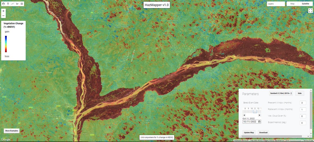
October flood woes along the #Niger and #Benue Rivers is clearly visible using #Sentinel2 imagery and the @HazMapper#rdNDVI algorithm. Contiguous red areas = loss of vegetation during #NigeriaFloods inundation. Explore yourself with the direct URL at https://t.co/4ndauu4vDv;
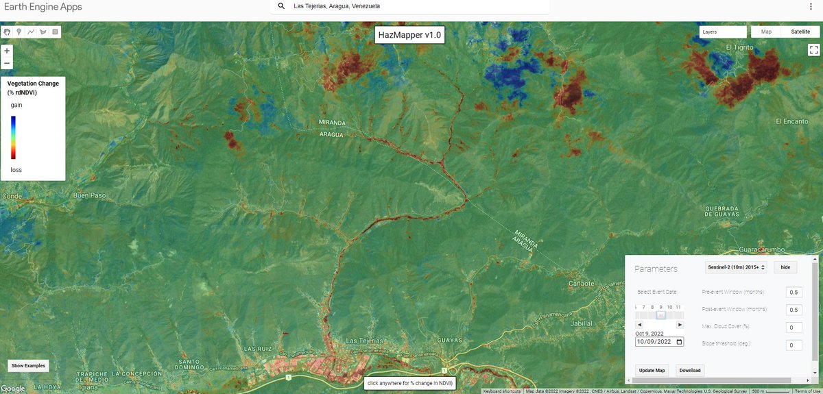
For those following the Oct 8-9 Las Tejerías landslide disaster in Venezuela, the @HazMapper +rdNDVI output clearly shows the shallow landslides and debris flows. Explore in HazMapper at https://t.co/D6GRyjqaGm; and see @davepetley blog post-https://t.co/gcvgcauPgU
@stress_driven Hey Kerry, very cool image! And awesome images throughout that report. We may offer a WMS link in the future, though a few details to work out, mainly regarding how long the image services stay active without being reinitiated. Cheers.
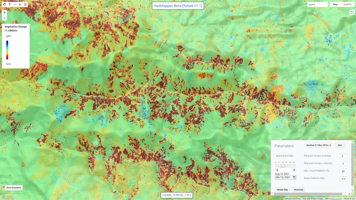
A quick comparison of mapping landslides (August 2021 Nippes EQ in #Haiti) in the original HazMapper compared to the beta v1.1 which includes moving from TOA to SR Sentinel data and some additional cloud filtering techniques.
#googleearthengine#gee#bigdata#naturalhazards
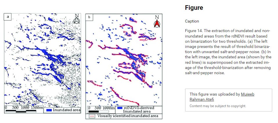
The rdNDVI metric is also useful for identifying vegetative stress from #flooding. Very cool to see researchers implement HazMapper for a flooding study in Afghanistan! Recent article from Atefi and Miura. Good stuff!!
https://t.co/n76jDxXh9u
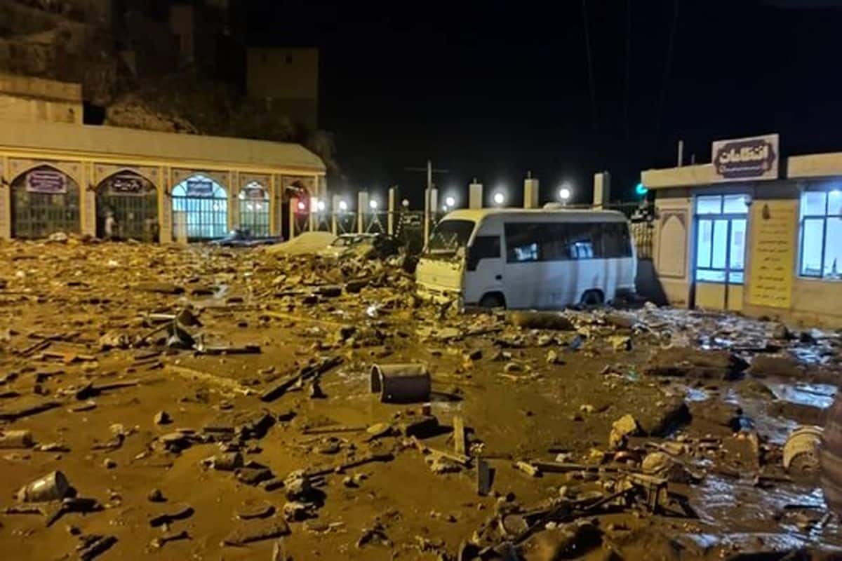
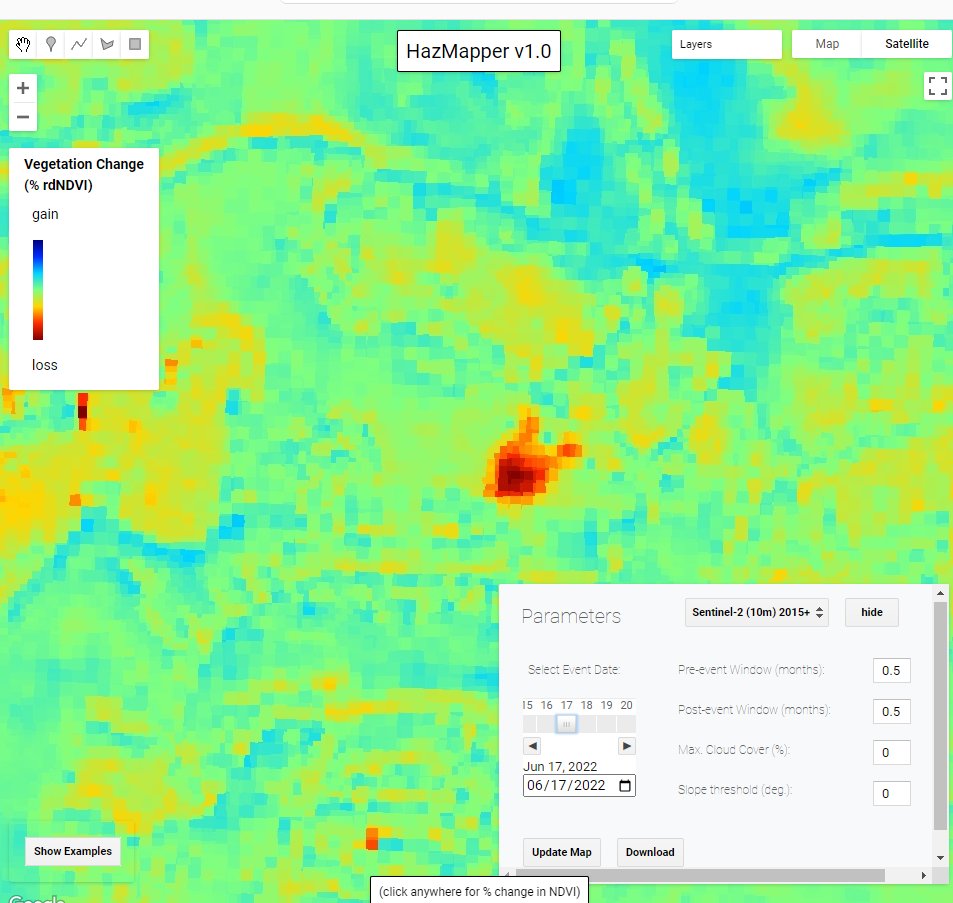
Lots of #debrisflows initiating on the high topography around Emamzadeh Davod last week.
A cloud is right over town in the latest #Sentinal2 image but still can see the track via link below. You'll see many more panning to the NW
https://t.co/6om6MTQLbo;
The 27 July 2022 Imamzadeh Dawood mudflow disaster in the mountains near Tehran is one of a number of recent landslides in Iran over the last week or so. At least 100 people have been killed or are missing:- https://t.co/iH28F3Sjaf
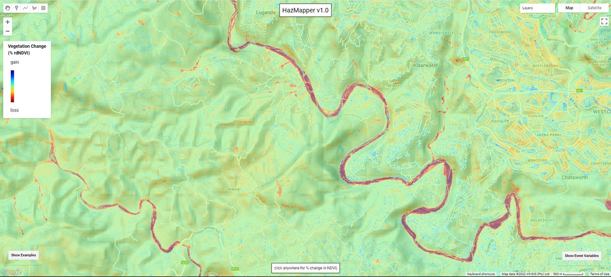
HazMapper Weekly Update #22 - April 2022 flooding and minor landsliding along the Mlazi (uMalzi) River, on the suburban fringe of Durban, South Africa.
Check out the @HazMapper pre-post GIF of the August 7, 2021, rainfall-induced landslide on Mt. Silabaku, Taiwan, and the resulting debris flow along the Yusui Stream. Inspiration from the new paper in the journal #Landslides by Che-Ming Yang and coauthors https://t.co/3zH0W19LZK
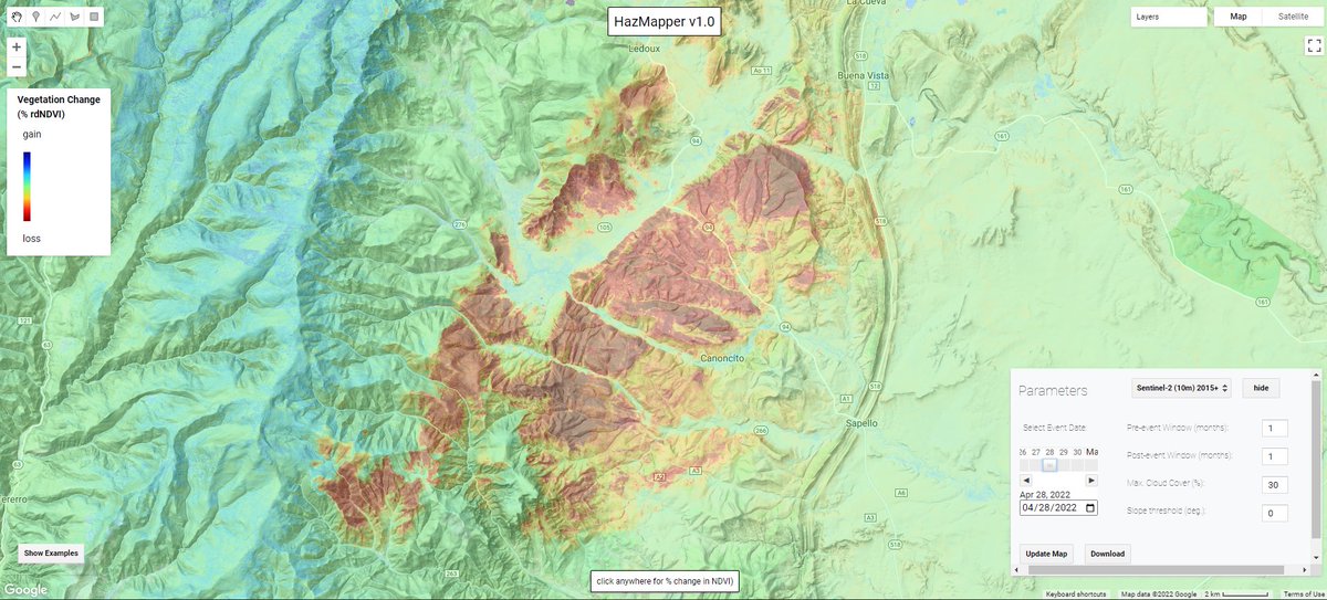
Another large fire in New Mexico, this time the 100,000+ acre combined #CalfCanyonFire and #HermitsPeakFire, seen here as of April 28th #rdNDVI vegetation change map (reds = veg loss due to fire). Explore in @HazMapper at direct URL: https://t.co/NxF1tUfEYi; @inciweb@SantafeNF
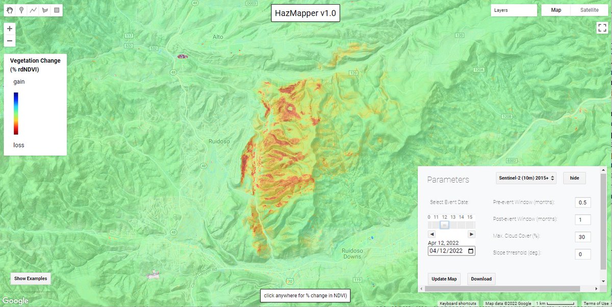
@HazMapper fire intensity proxy (#ndvi) map for the #McBrideFire near #Ruidoso, #NewMexico as of April 12, 2022, using #Sentinel2 imagery and #EarthEngine. The fire has caused several fatalities and destroyed more than 200 homes. Direct Hazmapper URL:https://t.co/n2BN5bn420;
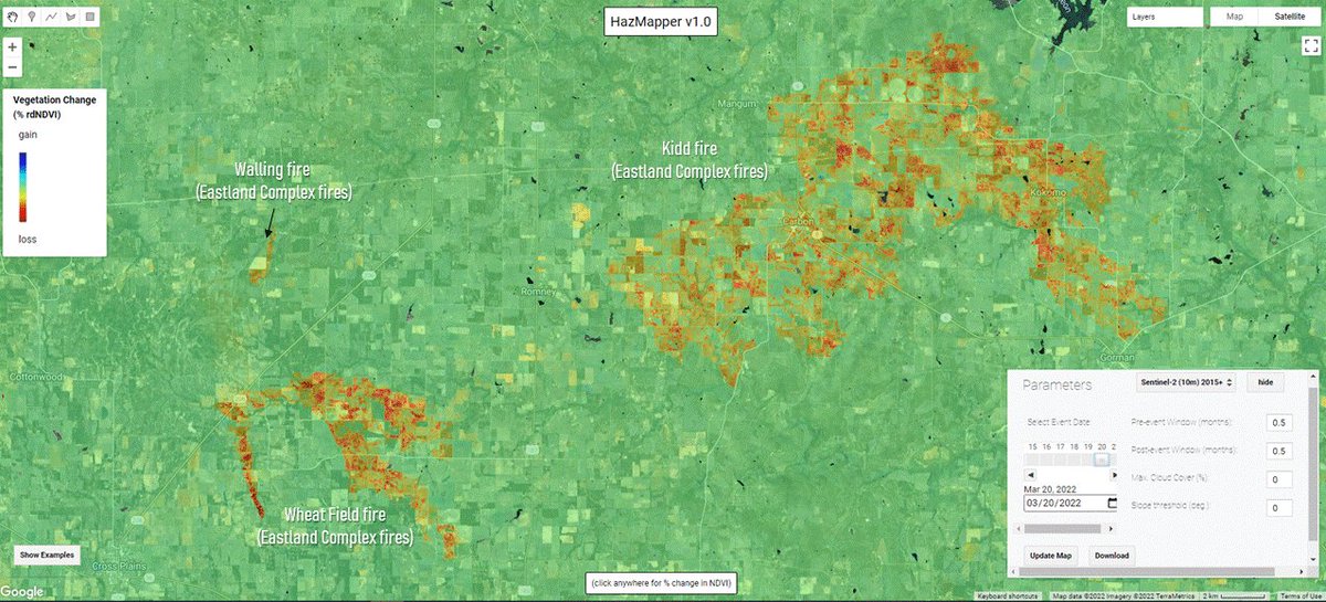
@HazMapper#NDVI change-detection result for the ongoing March #wildfires in central #Texas that are part of the #EastlandComplex. Fires are located between the cities of Cross Plains and Gorman. Warm colors = vegetation loss due to fire activity. @inciweb@TDEM
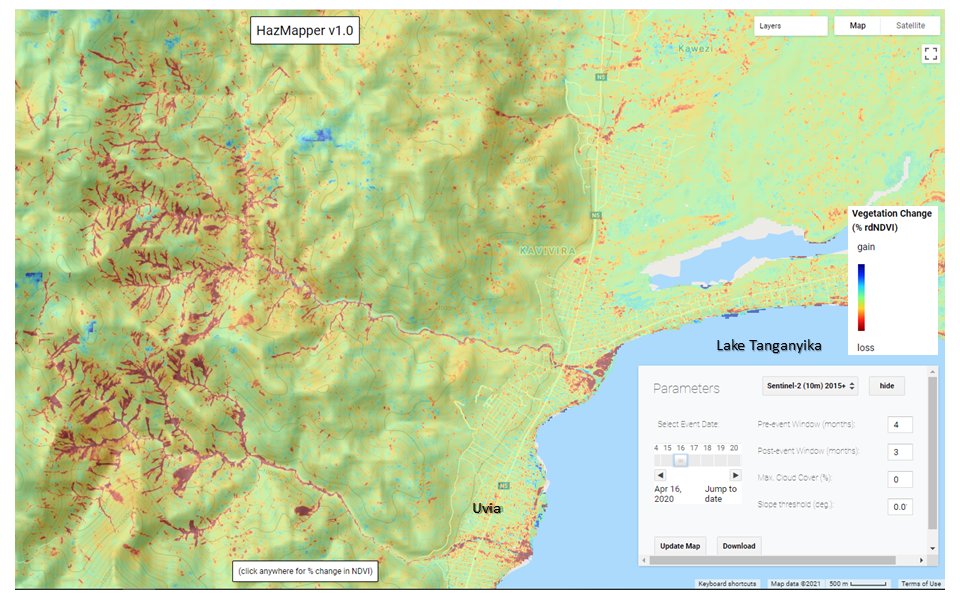
April 2020, heavy rains triggered hundreds of landslides along the rift-flank mountains west of Lake Tanganyika. Resulting debris flows and floods caused substantial damage in #Uvia#DRC. @HazMapper#rdNDVI image is a nice example of #SourceToSink sediment transport.
One year on from significant #landslide and debris flow events in Quang Tri Province, #Vietnam caused by the consecutive passage of multiple tropical cyclones.
Explore with @HazMapper URL: https://t.co/TXDsjQ7xqY;
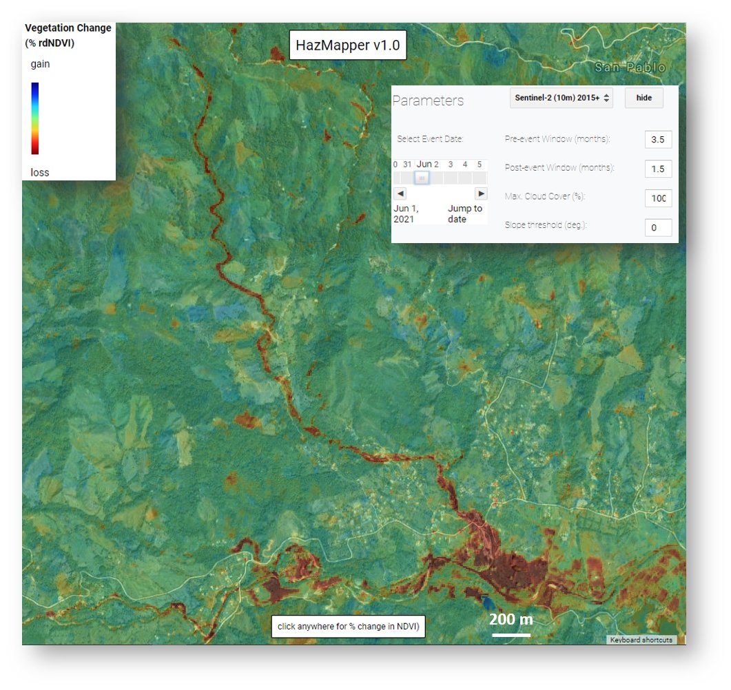
June 2021 #DebrisFlow and flooding near Santa Rosa de Osos, Antioquia, #Columbia. Red colors show vegetation loss due to transport and deposition of material on debris fan where the village is situated. #NaturalHazards#GEE#sentinel2
June 2021 #DebrisFlow and flooding near Santa Rosa de Osos, Antioquia, #Columbia. Red colors show vegetation loss due to transport and deposition of material on debris fan where the village is situated. #NaturalHazards#GEE#sentinel2
@HazMapper#rdNDVI result for May 2021 Mt. Nyiragongo lava flows, #DRCongo. Unfortunately, these resulted in the loss of life and destruction of > 1000 homes north of #Goma.
Explore with the direct URL: https://t.co/8jMq32Co8I;
And here is the direct URL for the @HazMapper#rdNDVI change result for the June 2020 outburst flood in the vicinity of #Melamchi#Nepal.
https://t.co/H1HB4SVgc8;
In June 2021, a ~500 m wide landslide temporarily blocked the Melamchi River of Nepal. The #Outburst flood caused significant damage and loss of life ~25 km downstream in the town of #Melamchi; @nepalflyinglabs.
Explore the event via @HazMapper direct URL https://t.co/moZgyf1MV4
Here is the direct URL for the @HazMapper#rdNDVI change result for the June 2020 river-blocking landslide near Melamchigaon village, #Nepal.
https://t.co/wUDl7XZdi3