This sight will be used to share "Emergency Management" notifications and updates. We will strive to forward current information regarding local emergencies
High wind and rain event over the next 12-24 hours. Secure loose items that are outside. The ground is saturated with more rain to come. Power outages are a possibility along with localized flooding
forecasted wind gusts 45-50 mph or greater.
The power is out to much of town due to one of the feeder lines being compromised. We don’t currently have a restoration time because the weather conditions are unsafe for operations. More updates to come when they become available
All Town departments are making preparations for the storm. Be prepared with your emergency supplies and have a plan to keep yourselves safe
https://t.co/NW05NIwKAY
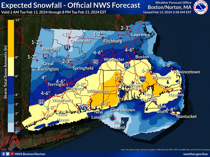
[High Impact Winter Storm] A major winter storm will bring heavy snow with blizzard conditions and power outages possible. High confidence in 10 to 20 inches of snow across eastern MA/RI, but more uncertainty across western MA/CT dependent on the western extent of heavy snow.
Confidence is "HIGH" that we will have a major Nor-Easter heading our way Sunday early evening and through Monday. Snow predictions are 16-24", moderate coastal impacts and strong gusting winds that may produce Blizzard conditions. please take time now to prepare
The Hull Fire and Police Departments, along with other Police and Fire agencies, will be conducting joint training exercises at the Memorial Middle School on April 24th and 25th. You may notice a large number of public safety personnel in the area. This is only an exercise.
FINAL UPDATE 911 OUTAGE:
All 911 systems for Hull, Hingham, Cohasset and Norwell are fully restored we are receiving 911 calls from all communities into the SSRECC.
URGENT MESSAGE
The State wide 911 system is down due to an issue on the North Shore. If you need police fire or EMS please call this number direct in the regional dispatch Center in Hingham,
781-740-0277
We will issue an update as soon as more information is available
moderate coastal flooding around town today with snow total predictions lower than yesterday, gusty winds expected with possible power outages, NO COMMUTER PARKING at Pemberton Pier in ALL LOTS and STREET SPACES due to flooding concerns, still a chance for Flooding on Wed
Storm system with high gusty winds S-SE 50+, possibly 1-2" of rain, very high tides Friday night and Saturday around midday. Duration is short but impacts may be moderate, flood prone areas will likely be affected. Travel may be difficult Saturday due to tides and flooding
Date and time change: HMLP will now be running town wide generator test on 12/15 from 330pm to 530 pm. Power will be cycled on and off throughout town during the test. Please direct questions to the Hull Municipal Light Plant. Take care to protect sensitive electronic equipment
As the sun rises over the Atlantic this morning, @NOAA's #GOESEast 🛰️ is continuing to monitor #HurricaneLee, churning northeast of Puerto Rico. #Lee is currently a major Category 3 storm and will produce hazardous surf and rip currents along beaches from the Virgin Islands to the southeastern U.S. today.
Latest: https://t.co/g8o6QiSK83
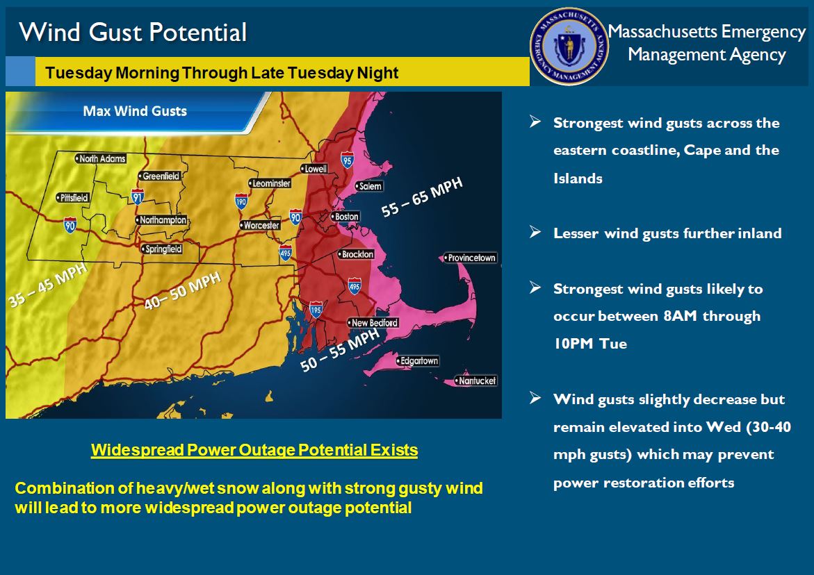
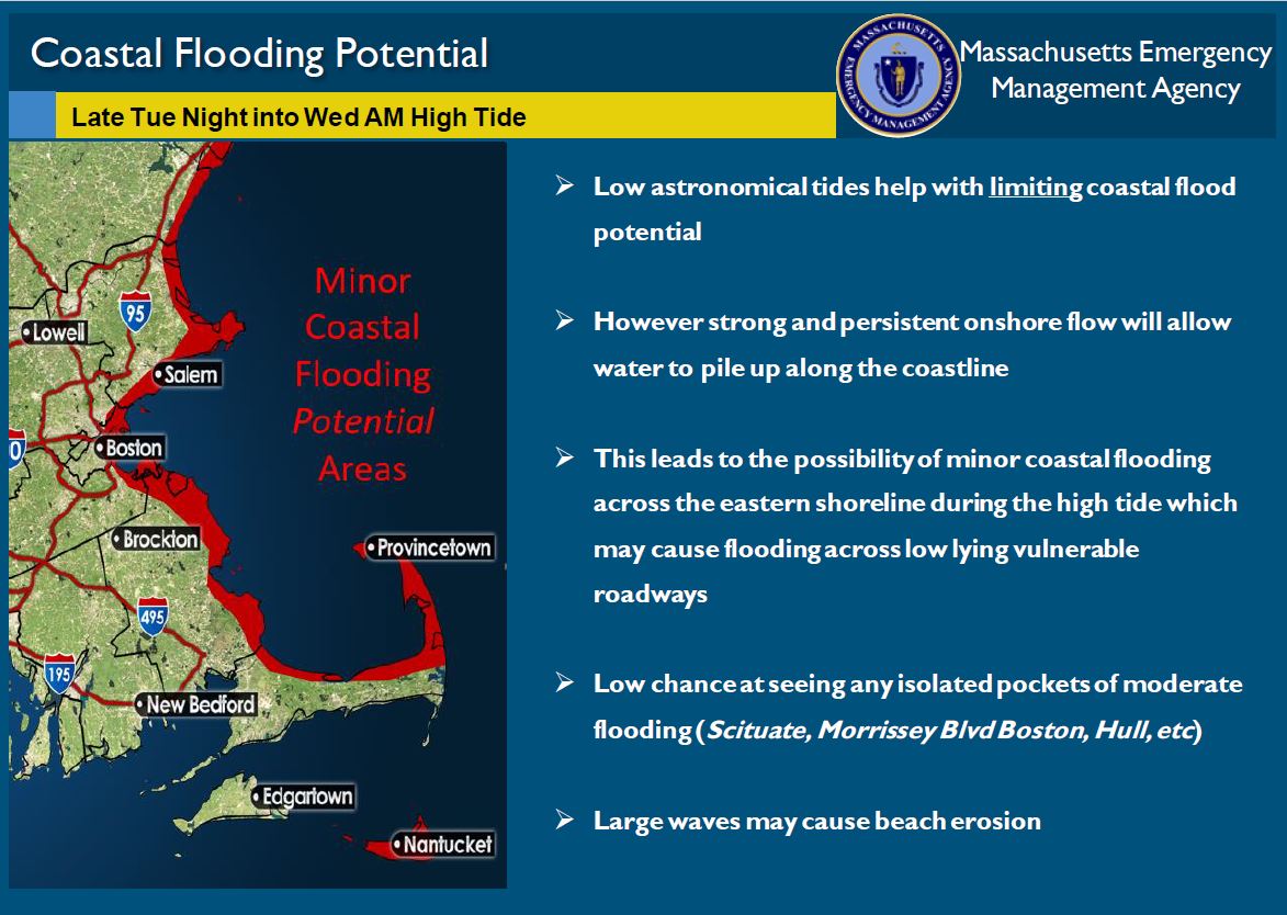
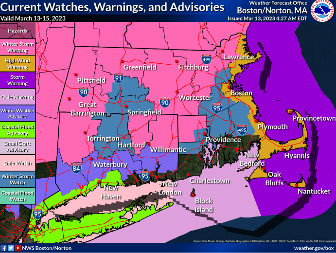
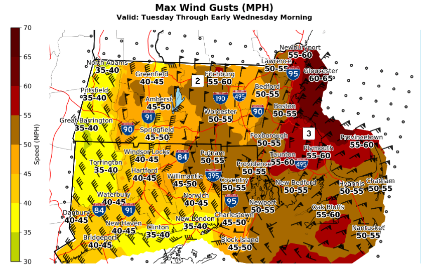
Strong Nor'easter to impact Tues 3/14 through Wed 3/15.
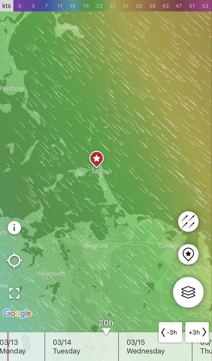
Strong Gusty winds will be present with some expected flooding in low lying areas along with Beach erosion. Potential for power outages.
STORM IMPACT UPDATE:
Per MBTA & Hull Harbor Master ferry service for Hull and Hingham cancelled for Tuesday 3/14
If there are changes we will update accordingly.
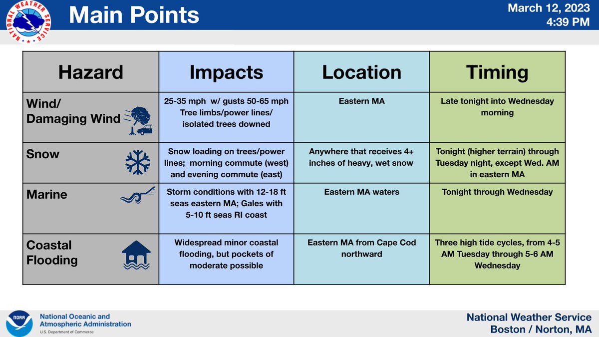
HIGH WIND WARNING FROM 8 AM TUES TO 8 AM EDT WED. Northeast winds 30 to 40 mph with gusts up to 65 mph expected. Damaging winds may blow down trees and power lines. Risk for power outages. Travel will be difficult, Peak of the winds expected Tuesday afternoon through the night
Powerful coastal storm will bring several impacts late tonight thru early Wed. Greatest impacts are wet snow weighing on trees & powerlines & damaging wind gusts. Coastal flooding near the Tue PM high tide.
Latest snow & wind gust forecast, weather headlines & Key Points:
Storm snow totals 1-3" with a “Coastal Flood Watch" for the wednesday morning tide, surge is still at 2-3' our winds will be 30-45 w gust to 60-65 starting early Tuesday morning.
The surge is important to watch, flooding is probable in flood prone areas
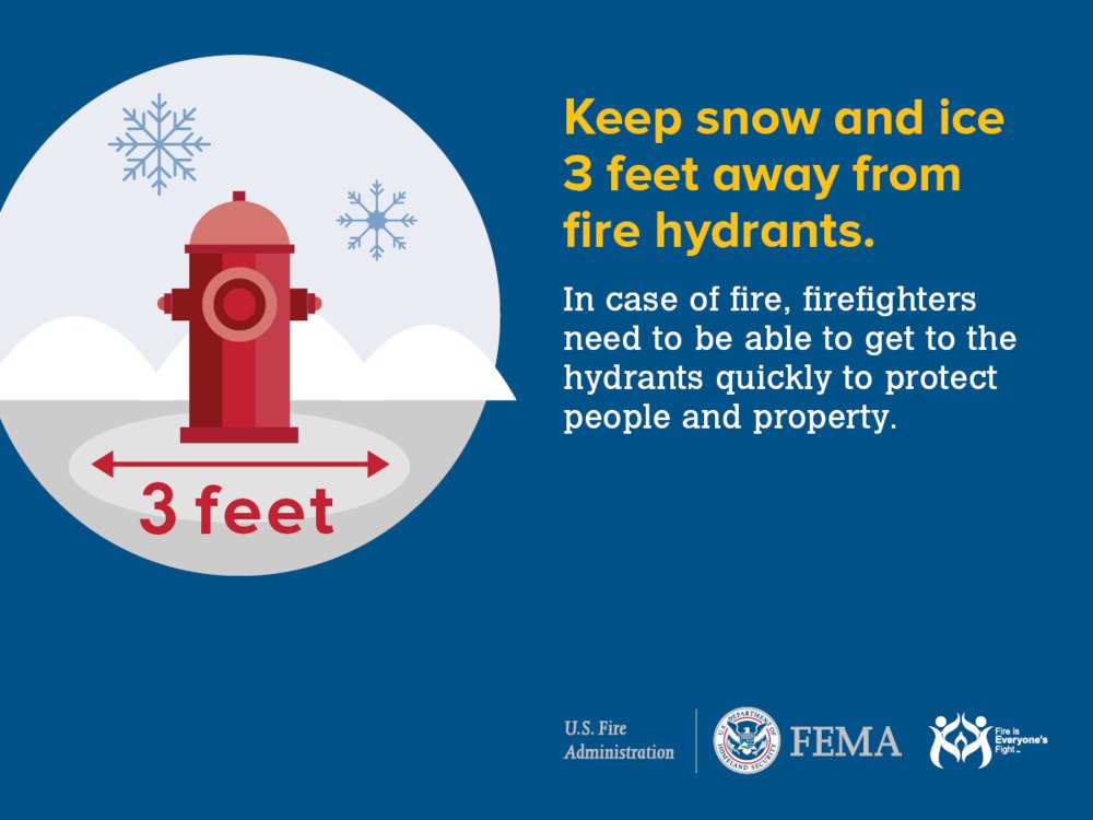
Fire Hydrant Winter Safety
The Hull Fire Department is reminding everyone to clear the snow and ice at least 3 feet away from fire hydrants if you are willing and safely able to do so. This will allow firefighters rapid access to protect people and property.




![NWSBoston's tweet photo. [High Impact Winter Storm] A major winter storm will bring heavy snow with blizzard conditions and power outages possible. High confidence in 10 to 20 inches of snow across eastern MA/RI, but more uncertainty across western MA/CT dependent on the western extent of heavy snow. https://t.co/PKCOYSg87M](https://pbs.twimg.com/media/HBr5NjzWUAEONbZ.jpg)