Short range models continue to show a very dicey commute home this evening around WNC. Rain will switch to heavy snow between 3-5pm for most around the area with locations farther west seeing that switchover occurring sooner. A quick 1"-3" is certainly possible from this as the burst moves through, then as the evening progresses we will switch to Northwest Flow Snow.
Below you can see the projected radar around 4pm for WNC per the NAM 3km. I have also included a cursor that indicates the projected snowfall rate per hour. You can see that this line could potentially have rates of 2"+ per hour. This is very heavy snowfall. Please be mindful that heavy rates like this could accumulate on the roads, even though soil temps are high. It would be wise to be heading home around 2-3pm today.
Winds will really ramp up as the afternoon progresses and we will likely see gust over 35mph even in the Asheville area. Blowing snow and high winds will create difficult driving conditions, especially north of I-40. It would be best to stay in this evening if possible.
Power outages can't be ruled out with snowfall and high winds. Please be prepared to go a day or so without power as crews work to restore in temps below 20 degrees.
Low temperatures tomorrow morning look to fall close to 20 degrees or below. Wind chills will be below zero and all around it looks to be a very nasty day as well. My best advice for this storm is to be in by 3pm today, the weather is going to turn unfavorable after that and there could be some road closures if snow falls heavy enough. Check https://t.co/bV8FfHocbu for live views as the snow falls!
March 16th 7:20am A Tornado warning has been issued for parts of Madison & Yancey Counties. Please seek shelter immediately! This is radar indicated, nothing confirmed on the ground, but this storm needs to be taken seroiusly!
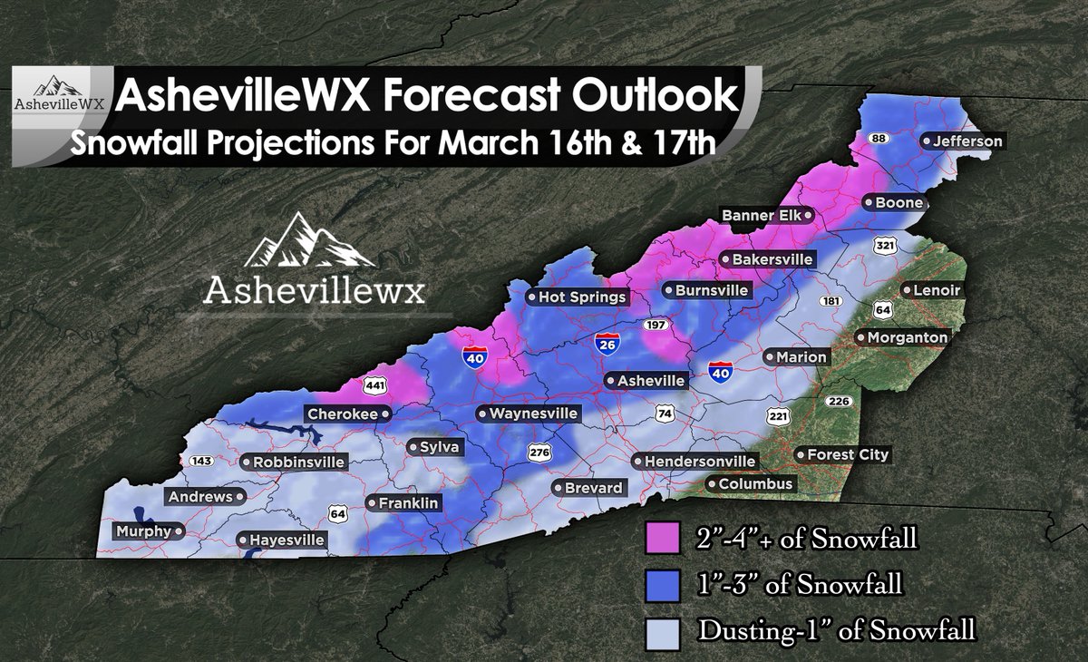
Heavy rain will change to snow tomorrow afternoon(2-6pm) for most all of WNC, and that could cause some issues around the area. Surface temperatures are warm so accumulation will be difficult, but most models are showing heavy enough rates for some accumulation. Here is my projected snowfall map through Tuesday for WNC. I think many will see 1"-3" on grassy surfaces with a slush on the roadways. Others will see a dusting, with isolated higher elevation locations seeing over 4" of snowfall.
High wind gusts are certain through Tuesday morning and that means isolated power outages will be possible. Be prepared to lose power for 24 hours or so, just in case. Temperatures will plummet into the mid 20's early Tuesday morning so be mindful of this. Plants that have bloomed out will likely be killed without some type of protection and that still may not help.
For a more in depth analysis regarding this system, go to the video that is also just posted. I will do another update tomorrow if there is more information to provide!
Check https://t.co/bV8FfHocbu for live looks around WNC!
Strong storms will push into WNC early tomorrow morning, then a switch to heavy snow is possible during the afternoon hours. This could affect your afternoon commute around the area. Here is everything you need to know to get you prepared for the approaching system.
I am watching a strong front will bring the chance for severe storms & snow to WNC tomorrow. Storms will move through between 5am & Noon, then as the rain continues temperatures will crash and most locations will transition to snowfall. Models project that most everyone will switchover around WNC by 4-5pm and many locations will see accumulation. Then Northwest flow snowfall will persists through the day on Tuesday. There is a lot to unpack with this front, so I'll post a video later today.
Along with snowfall, I am worried about the cold temperatures that will follow. Most models have the area in the low 20's on both Tuesday and Wednesday morning. This will have a huge impact on trees that have bloomed out. Below you can see the most recent NAM 3km snowfall projections. It agrees with the GFS, but the European model is only showing a dusting. Check back soon for my snowfall map and a video update to get you ready for this system.
Heavy rain will move through WNC early tomorrow morning, bringing with it much needed precipitation. Some models though have the precip switching over to snowfall, especially in the higher elevations as it exits. Below check out the projected radar between 9-10am tomorrow morning per the Nam 3km model. You can see as heavy rain really gets going, the column of air cools and many switch over to sleet or snow.
Timing: This front looks to move in with an initial round of Thunderstorms early tomorrow morning between 1-3am. Then, another line of precipitation will push through between 8am-noon. This will be the time frame in which I think some wintry weather will be possible.
Total Snow?: Some models indicate a dusting is possible around the Asheville area, but I am hesitant. Ground temps are very warm and it will really take a heavy burst of snow to accumulate, but it could happen. Closer to the NC/TN border, I could see a few inches of snowfall accumulation before the sun rises. Locations like Mars Hill could see a surprise 1"-2" quick inches from a heavy burst as the sun begins to rise tomorrow morning. Be mindful of this uncertainty.
Freezing Temperatures: Many trees have bloomed out, and I am concerned about a frost on Friday morning for many in the area. Temperatures will dip in to low 30's and upper 20's and with winds dying down a frost is certainly possible. Please take precautions with tender vegetation.
Total Precipitation: We are in a pretty significant drought here in WNC and while this system won't burst it, it will provide a bit of aid. I am seeing most locations picking up .3"-.6" of rainfall from the system as it moves through.
Road Concerns?: Higher elevations above 3000' could have issues tomorrow morning since they are likely to switch to snow before the sun rises. Around Asheville I think the switch over will occur as the sun is rising so there will be less chance for anything to accumulate, especially on the roadways.
Looking Ahead: Frost is possible on Friday morning, please take those precautions for tender plants. Temps will rebound on Friday afternoon into upper 50's and low 60's. Looking ahead to the weekend and high temps will push close to 70 degrees each day with only a few chances for showers late Sunday afternoon/evening. Enjoy!
Go Heels! So happy to share this experience with my dad this year! The Heels went 9-0 at the games we were at. Hoping to bring that luck next week to the ACC tournament.
Snow showers have started for many across WNC, and I expect them to pick up as the afternoon progresses. Several valley locations look to see a dusting to 1" of accumulation from this while locations above 3500' could see 4"-6"+ through Monday afternoon. Here is my latest video update to get you ready for the system that is moving in!