A rare, heavy rainstorm occurred near Evergreen, CO last night. Data from a Personal Weather Station, below, suggests a ~0.1% ("1 in 1000-yr") Annual Exceedance Probability event at the 1-hr duration and possibly ~0.01% at 2-hr. #cowx#coflood
There's a 1-hour QPF of 5.6 inches in Colorado today from the RRFS FV3 system. Storm total amount of 9 inches. This would be a 1 in 10,000 year intensity. The FV3 core appears to have many issues w/QPF, so use caution given upcoming changes w/NCEP. #cowx
@COFloodUpdates Re: White River, here's the historical snapshot of daily flow. Closest analog for this year is 2002 and 2012, both of which were top 5 #cofire years. But even those years had much higher spring runoff volume. #cowx#coflood
Today in #cowx, almost all NWP showed a 10-30F bust in 2-m dewpoint temp at 6-hr lead time at DIA. Even at 1-2 hour lead time, there were consistent 5-10F busts. It's a hard-knock life as a met.
Heavy rainfall moved through the Denver Metro this afternoon (Mon, Jun 1st). This @mhfdfws ALERT gauge in Aurora picked up 2.05 inches/30-minutes & 2.44 inches/1-hour. Both intensities are a 1% Annual Exceedance Probablity. #cowx#COflood#mhfdrain
Re: "Rio Grande goes dry every year", kind of. Here's the 1896-2026 flow data at Otowi Bridge (sw of Taos). While the river frequently sees low flows, it's extremely rare 'til about late June. Plus, this year's daily avg peak is 831cfs, which is 20% below previous low. #nmwx
@COFloodUpdates@NRCS_CO Expanding out to the longer ~109 year @USGS record reveals the same thing: Apr 2026 was the lowest recorded volume on the North Platte River @ Northgate. The next closest years (1995, 1981) both had >1,000 cfs peaks during May/June. We shall see if that occurs this year. #cowx
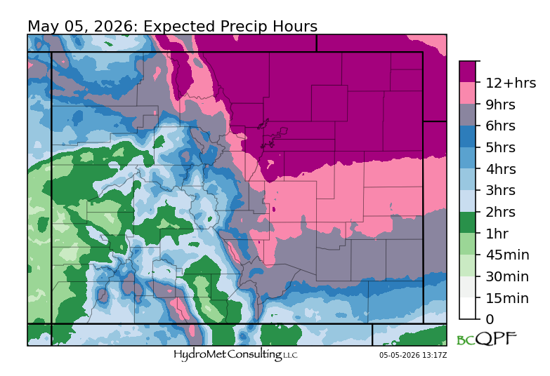
@COFloodUpdates Cache La Poudre basin again the target for highest storm total precip with this storm, almost exactly same location as the May 5-6 event! #cowx
Precipitation chances increase today after a week of drier #cowx. Heavier rainfall is possible over the Northeast Plains alongside a severe threat, while NW Colorado should see an extended period of PM precip.
Quick analysis of snow depth versus elevation shows near linear dependence until about 7-8k feet, beyond which snow depth decreased again. We often see that same elevation range emerge as the "winner" in heavy rainstorms too, such as the 2013 Front Range flood. #cowx
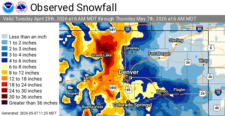
❄️❄️This late season winter storm brought significant snowfall to the region: The Denver metro averaged between 4 and 8 inches with the highest totals located on the south and west sides of the metro! The mountains saw 1 to 2 feet of snow with Estes Park recording over 30 inches!
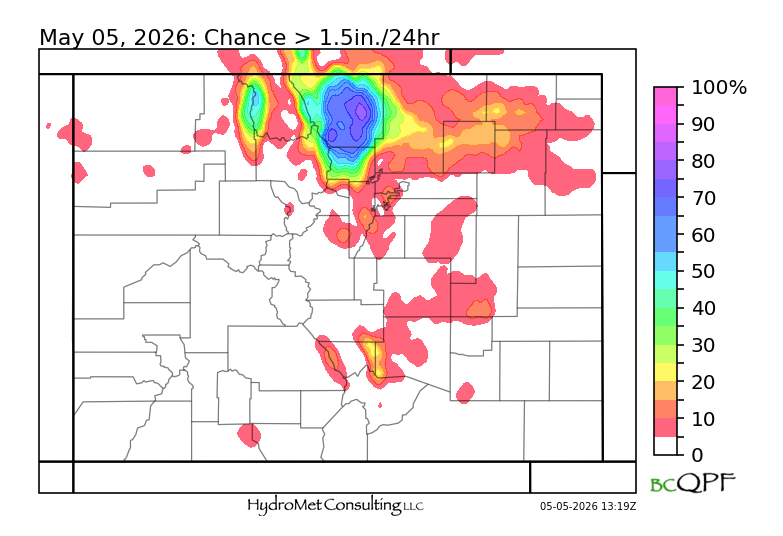
Some interesting guidance from our large CAMs wx model ensemble on today's #cowx and #wywx snow-storm. First, there's a very large gradient in "Precip hours" highlighting preferred terrain-dynamics combos. Second, probability of exceeding 1.5in liquid in 24 hours has distinct mesoscale bullseye in Cache La Poudre basin.
Hey #cowx and #wxtwitter, we are searching for a summer intern (meteorologist) to help advance our hydro-meteorological forecast operations and other R&D projects.
Check out the attached posting, and please share with others that may be interested!
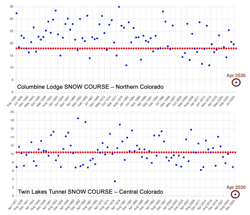
Plenty has been said about the incredibly low Colorado snowpack for early April. Most data has used the <45-year @USDA_NRCS SNOTEL record. Looking much further back at several >85-year SNOW COURSE sites reveals the same thing: unprecedented low values. #cowx
If you are a meteorologist, hydrologist or just a casual weather/water geek, consider giving to the CoCoRaHS 2025 Year-End Fundraiser! It's one of the best volunteer-driven networks ever created with 1,000s of high quality measurements per day. #CoCoRaHS#cowx https://t.co/cR8ch3xIfk
(1/3) The recent San Juan River flow at Pagosa Springs has been near unprecedented levels for October. This shows the 1935-present daily avg. data. The peak flow during this event was at least 5x higher than the snowpack-related peak earlier in the year. #cowx#coflood
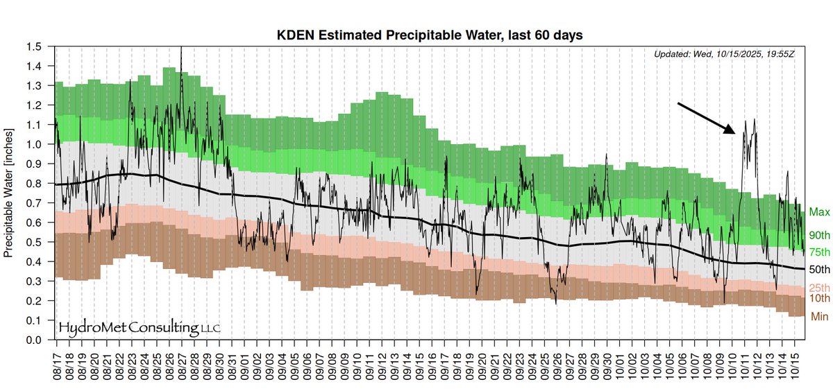
(3/3) The driver of this recent event was moisture of subtropical origin that spiked Precipitable Water (PW) levels far beyond anything measured over past ~70 years in Oct. This shows the estimated Denver PW, which was on the fringe of the main moisture surge. #cowx#coflood
(2/3) The peak from the past storm was likely the highest since a major flood in 1911. However, the double peak nature of this storm is notable. Here's a USGS paper that discusses the 1911 event, which focused on the adjacent Animas River. #cowx#coflood
https://t.co/iV3fhlOadG