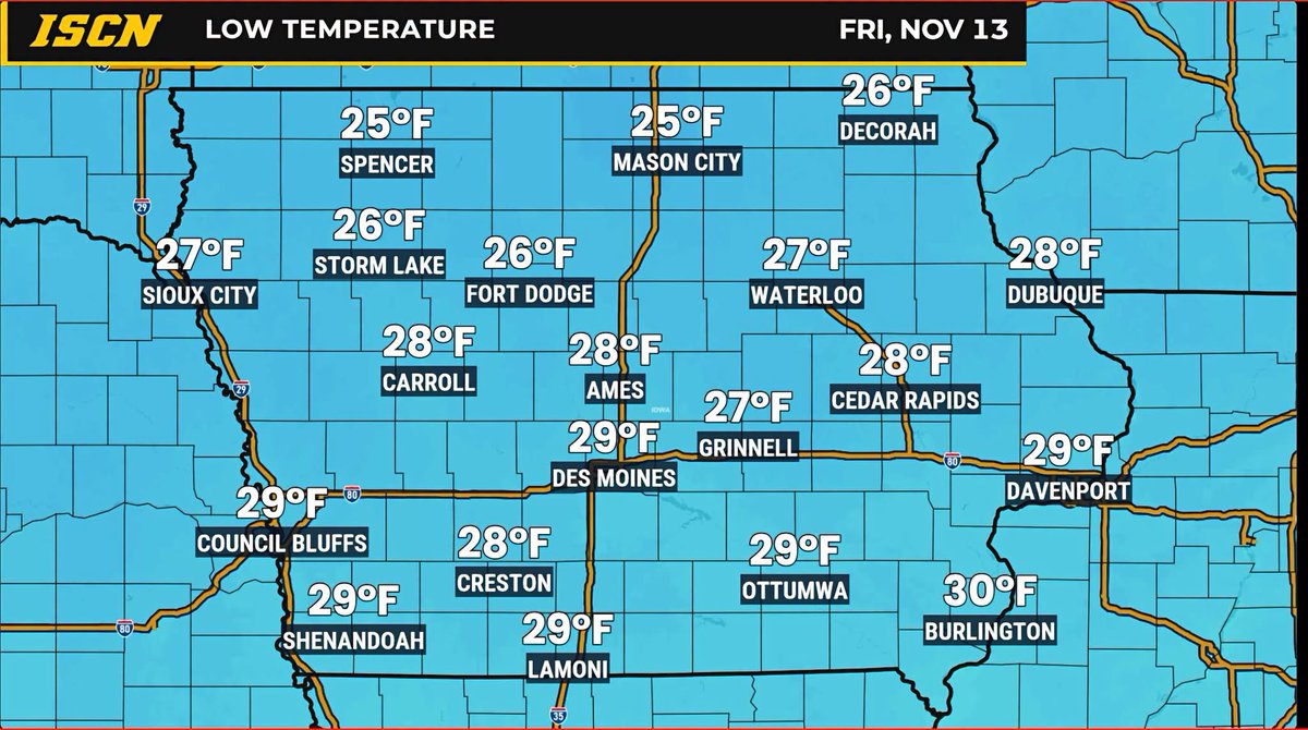
Get those coats ready! Some of the coldest temperatures we've seen so far this fall are expected Friday morning as a much colder air mass settles across Iowa.
Morning low temperatures will fall into the 20s across much of the state, with some locations in northern and northwestern Iowa potentially dipping into the upper teens.
For many communities, this could be the coldest morning of the fall season so far! The chilly weather will stick around through the weekend, with afternoon highs generally in the upper 30s and 40s. Saturday morning could be even colder in some areas, especially where skies clear and winds become light.
The good news? A gradual warming trend is expected early next week.
Stay ahead of Iowa's changing weather! Download the FREE ISCN Weather app for the latest forecasts and weather updates, or watch our 24/7 weather channel anytime at https://t.co/g5019NBJXh!
Morning thunderstorms, gusty northwest winds, and a big cooldown are all part of Iowa's weather story today! Highs drop into the 40s Thursday and Friday, with overnight lows in the 20s. What about the weekend?
Read our latest forecast at https://t.co/g5019NBc7J
https://t.co/pDk3kVqJ3Z
🥶 GET READY FOR A COLD FRIDAY MORNING!
We're watching the potential for widespread temperatures below feezing across Iowa by Friday morning!
Many communities could wake up to temperatures in the upper 20s and lower 30s, with some northern locations potentially even colder.
Clear skies, lighter winds, and a Canadian air mass could set the stage for one of the colder mornings we've experienced so far this fall.
#iawx #iowa #weather
IOWA, ENJOY THIS WHILE IT LASTS!
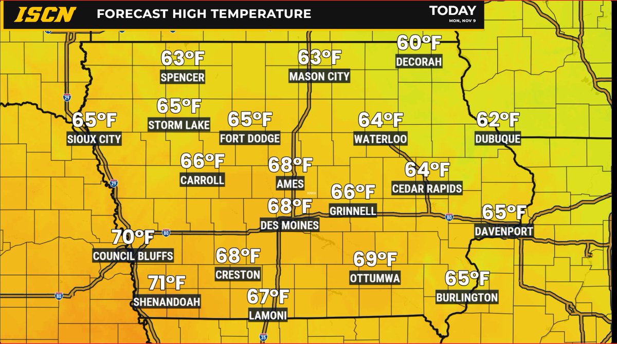
We're talking temperatures well into the 60s across much of Iowa today, with a few spots potentially reaching 70°! Not too shabby for November 9!
But don't get too comfortable! A BIG change in our weather is coming later this week, with temperatures expected to tumble 20 degrees or more in some areas.
So, how much longer will this November warmth stick around, and just how cold will it get? We've got the full breakdown in our latest Iowa weather forecast, including rain chances, the approaching cooldown, and what to expect heading into the weekend!
Read the latest forecast at https://t.co/bOXIdOYLNd
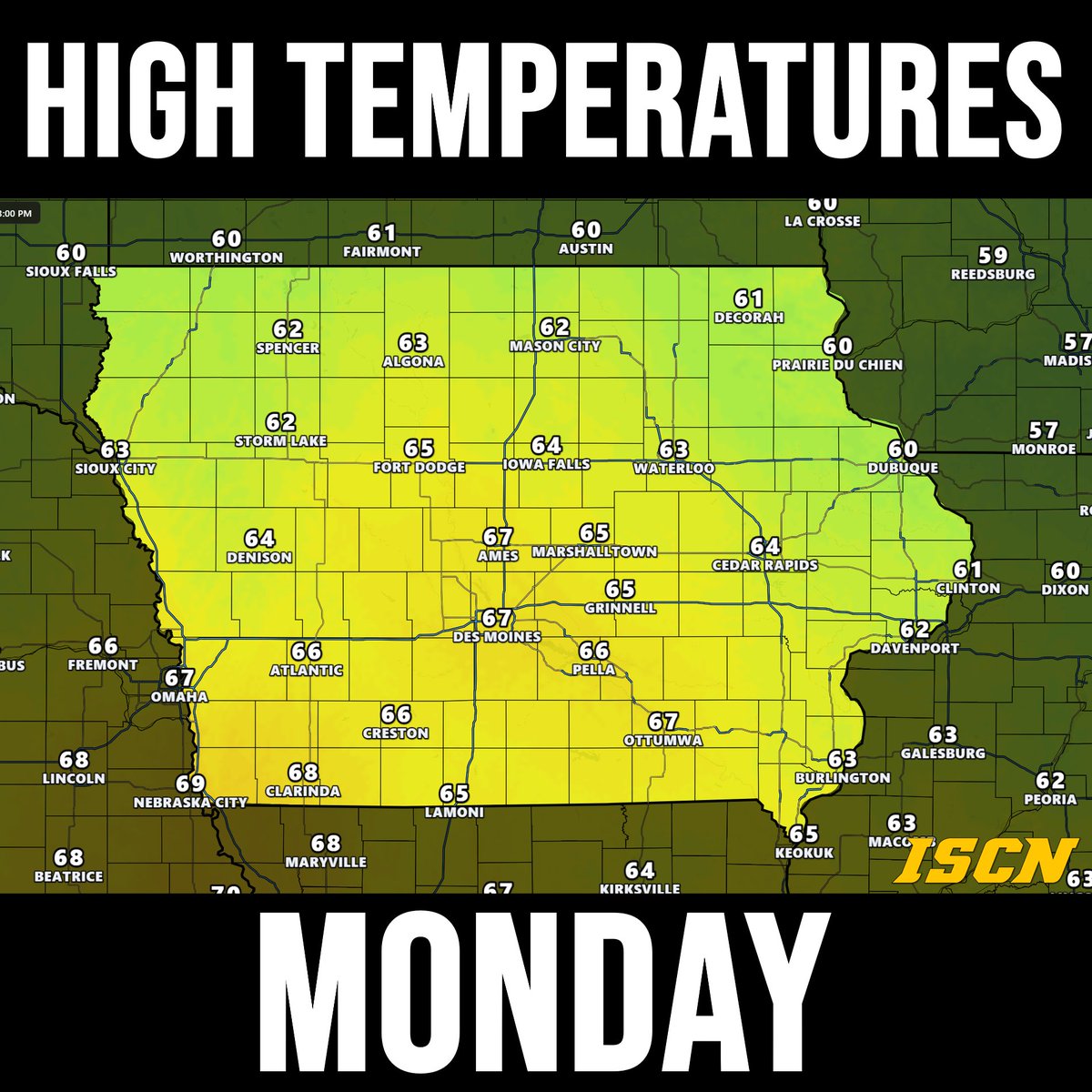
Monday is shaping up to be one of the nicest days of the week across Iowa! Highs will climb into the 60s, with some areas of western and southwestern Iowa potentially reaching the upper 60s to low 70s. Expect a mix of sunshine and clouds with a bit of a breeze.
Tuesday will remain mild, but BIG changes arrive during the second half of the week!
It's looking like Iowa could enjoy another taste of unusually mild weather early next week!
Monday is shaping up to be one of the warmest days, with widespread 60s expected across much of the state. Some communities in southern and western Iowa could even approach 70°!
That's pretty impressive for the second week of November. The best part? We're looking at mostly dry conditions through the weekend and into early next week.
#iawx #iowa #weather
It's a chilly start to Friday across Iowa, with areas of fog, patchy drizzle, and stubborn low clouds lingering across central and southern portions of the state.
The good news? Sunshine has already returned to parts of northeast and eastern Iowa! Meanwhile, areas farther west and south are still dealing with plenty of cloud cover, but we should see some gradual improvement as the day goes on.
Afternoon temperatures will generally top out in the 40s statewide, with the sunnier locations having a better chance of warming a few degrees more. Lighter winds will also make things feel a little more comfortable compared to the past few days.
And there's even better news heading into the weekend! A warming trend is on the way, with temperatures climbing into the 50s Saturday and widespread 60s possible by Sunday and Monday!
Stay ahead of changing conditions with the FREE ISCN Weather app, available for iPhone and Android. Watch our live Iowa weather channel anytime at https://t.co/nHUkhTBOpq
#iawx #iowa #weather
INTRODUCING https://t.co/V3Mkqgionf — IOWA'S NEW 24/7 WEATHER CHANNEL!
Iowa weather doesn't stop, and neither do we! We're excited to officially announce the launch of https://t.co/gUXXfvPjIW, bringing local Iowa weather directly to you 24 hours a day, 7 days a week, no matter where you are!
Whether you're at home, at work, or on the go, https://t.co/gUXXfvPjIW gives you around-the-clock access to weather information from across the state. From current conditions and local forecasts to live weather cameras and the latest weather updates, our new channel is designed to keep Iowans informed and connected to the weather that impacts their daily lives.
This marks an exciting new chapter for ISCN as we continue expanding our commitment to providing Iowans with reliable, locally focused weather information. We're bringing together the weather information you depend on into one convenient destination that's available whenever you need it.
And we're just getting started! https://t.co/gUXXfvPjIW is only the beginning of what we have planned. We've been working behind the scenes on something else exciting, and another BIG reveal is coming soon! Stay tuned, because this chapter is just starting!
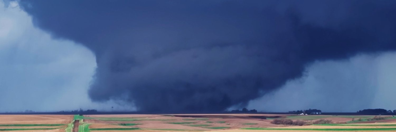
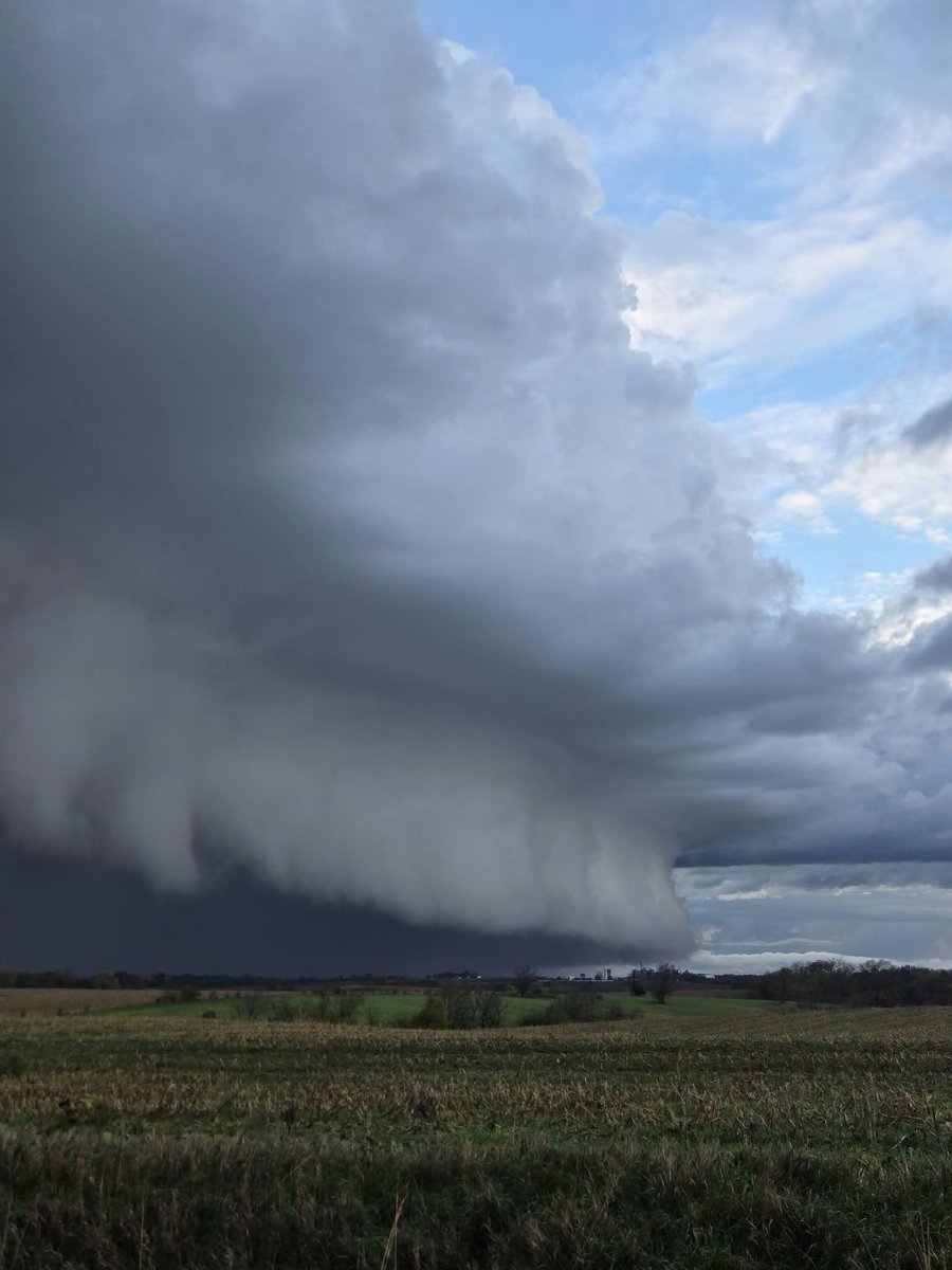
Check out this video shared with us by Brad DePrenger showing what appears to be a brief tornado spin-up near Otley, Iowa, just northwest of Pella, shortly before 2 PM Tuesday afternoon (November 3). @NWSDesMoines
A split temperature day across Iowa! As of 11 AM, temperatures ahead of the cold front are in the mid-60s, while areas behind the front have cooled into the low to mid-50s.
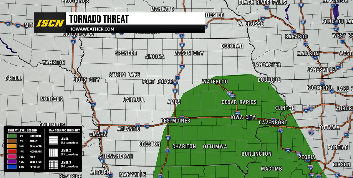
The Storm Prediction Center has expanded the Marginal Risk (Level 1 of 5) for severe weather farther north across portions of Iowa in its latest update issued at 10:26 AM Tuesday. While the overall severe weather threat remains low, a few brief tornadoes and isolated damaging wind gusts will be possible as thunderstorms develop and move through the region this afternoon and into the evening.
A strong storm system continues to move northeastward, with an area of low pressure expected to track into eastern Iowa later today. Strong winds in the lower levels of the atmosphere will create conditions favorable for some thunderstorms to briefly rotate. Although instability remains limited, the strength of the wind fields could be enough to support isolated severe storms, including the possibility of a brief tornado.
The northward expansion of the severe weather risk means additional areas of Iowa will need to monitor storm development closely, particularly across southern, central, and eastern portions of the state. This does not mean severe weather is guaranteed, but it does indicate that the potential for isolated severe storms extends farther north than previously anticipated.
Our team will continue monitoring the latest radar trends and storm development throughout the afternoon and evening. Make sure you have multiple ways to receive weather warnings, especially as storms move northeastward across the state.
(SPC UPDATE AT 10:26 AM TUESDAY)
The Storm Prediction Center has placed portions of southeast Iowa under a Marginal Risk (Level 1 of 5) for severe thunderstorms on Tuesday, November 3. While the overall severe weather threat remains low, a few storms could become strong enough to produce isolated damaging wind gusts and a brief tornado or two.
A storm system moving through the Midwest tonight will bring additional rounds of showers and thunderstorms to Iowa on Tuesday. The atmosphere will feature unusually high moisture levels for early November, along with strong wind shear that could allow some thunderstorms to develop rotation. However, limited instability and widespread cloud cover should help keep the overall severe weather threat isolated.
The greatest concern will be across southern and southeastern Iowa, particularly areas south of Interstate 80. The potential for stronger storms extends through the daytime hours Tuesday, with the early afternoon appearing to be a period of particular interest across southern Iowa.
This is not expected to be a widespread severe weather outbreak, but the potential for a brief tornado should not be overlooked. We'll continue monitoring the latest forecast trends and provide updates as the system moves through Iowa.
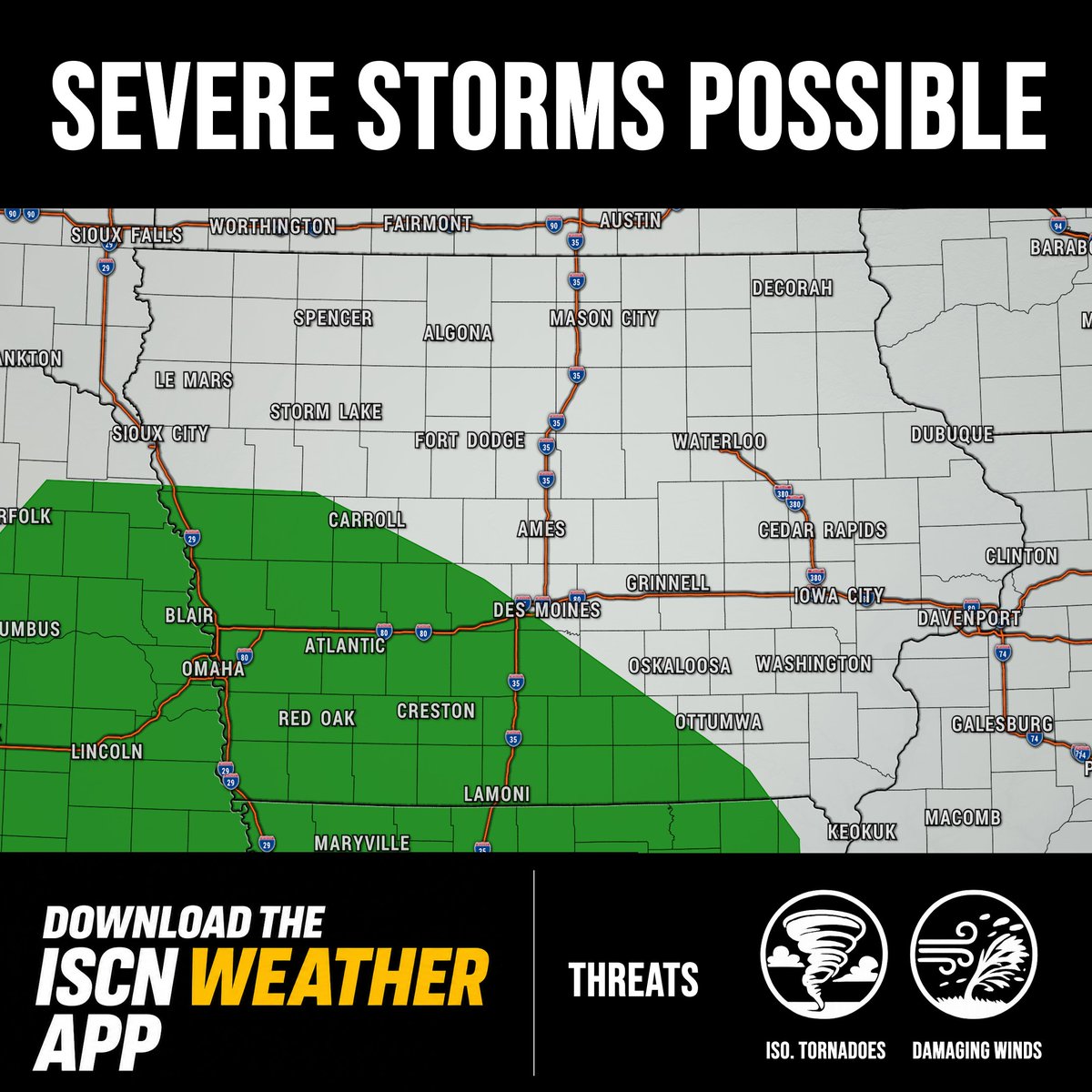
A strong storm system will move into Iowa on Monday, bringing widespread rain, gusty winds, and the potential for a few strong to severe thunderstorms, particularly across southern Iowa.
The primary concern will be damaging wind gusts, although a brief tornado or two cannot be ruled out. Strong wind shear will be in place, but the overall severe weather threat will depend heavily on how much instability can develop. Persistent cloud cover and morning rainfall could limit the threat.
Rain and thunderstorms will spread across Iowa late tonight into Monday morning, with the potential for stronger storms Monday afternoon and evening. Some storms could continue after dark.
While a widespread severe weather outbreak is not expected in Iowa, this is a system worth watching closely. We'll continue monitoring the latest data and provide updates as the threat becomes clearer.
Download the FREE ISCN Weather app for the latest Iowa weather updates, live radar, severe weather alerts, and forecasts right at your fingertips.
#iawx #iowa #severeweather
The Storm Prediction Center has introduced a Level 1 out of 5 (Marginal Risk) for severe thunderstorms across portions of northwest Iowa on Wednesday, October 28.
Thunderstorms may develop late Wednesday afternoon into the evening as a strong weather system moves into the region. While widespread severe weather is not expected, a few storms could become strong to severe.
Isolated large hail and damaging wind gusts will be the primary concerns. However, the severe weather threat remains conditional, as cloud cover and limited daytime heating could prevent storms from becoming severe.
We'll continue monitoring the latest forecast trends and provide updates as Wednesday's system approaches.
#iawx #iowa #severeweather
Could rain put a damper on Halloween plans across Iowa? Multiple rounds of showers and thunderstorms are possible this week, including a system that could impact trick-or-treating Saturday evening. #iawx#iowa#halloween
Latest weather forecast can be found at https://t.co/2icDyvTcmC
Temperatures will climb well into the 70s through Friday, with a few spots potentially reaching 80°! However, changes are on the way as gusty winds develop Friday, followed by increasing rain chances this weekend. 🌧️ A cold front will bring cooler, more seasonable temperatures by Sunday and Monday.
We've broken down what to expect, including when rain could arrive in your area! #iawx #iowa #weather
https://t.co/iGyOdpqQtI
Winds have started out on the gusty side for some this morning. We will likely see additional wind gusts throughout the day today. Wind gusts out of the south around 20 to 30 mph will be possible through early evening.