Many of you have reached out to us asking about the plans for this year’s INChaserCon. We appreciate all the interest & support, but we have encountered some road blocks & have decided to cancel this year’s event. We do hope to bring the event back in the future, thank you!
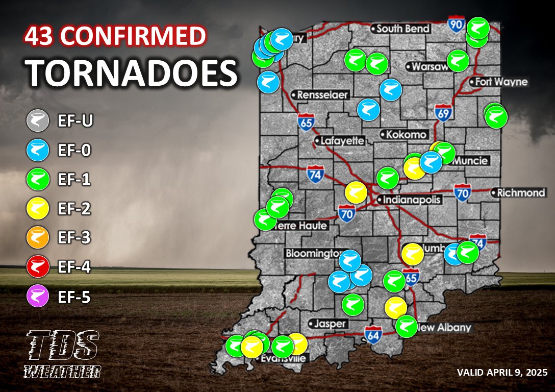
🌪️ The National Weather Service has confirmed a total of 43 tornadoes in Indiana in a span of just 19 days! Here are the 4 event totals:
March 15: 8
March 19: 7
March 30: 7
April 4: 21
A truly impressive start to the severe weather season, already double the annual average of 22 tornadoes. #INwx #Indy #Indiana #weather #tornado #tornadoes
⚠️Confidence is increasing on a strong and large storm in the northern Gulf of Mexico this week. With the designation of Invest Area #97L, we now have #hurricane model data coming in. The latest:
📈 Trends toward a more powerful storm
📍 Data is clustering potential landfall between Mobile, #Alabama and Tampa Bay, #Florida
📉 Trends for less wind shear
♨️ HOT Gulf waters available
🌀 Major Hurricane possible
📱Track the developing #Helene in the TDS Weather mobile app for FREE from the App Store and Google Play! We have you covered with forecasts, radar, NHC cones, tropical spaghetti models and more.
#LAwx #ALwx #MSwx #GAwx #FLwx #weather #tropicalwx #tropicalupdate #tropicalstorm
Many of you have reached out to us asking about the plans for this year’s INChaserCon. We appreciate all the interest & support, but we have encountered some road blocks & have decided to cancel this year’s event. We do hope to bring the event back in the future, thank you!
The NWS is hosting a central Indiana severe weather symposium at nearly the same time if you’re interested. More information can be found here.
https://t.co/85Ii9nyb9o
Have you downloaded the new TDS Weather mobile app yet!? It's FREE in the App Store and Google Play, and features the following:
📍 Location-based watches and warnings
🧍 Push alerts from our meteorologists
📡 Satellite and radar
🌡️ Current conditions, hourly, and daily forecasts
⛈️ SPC severe weather outlooks
🌀 Hurricane forecasts
...and more!
Apple: https://t.co/Cyh4rSPaoz
Google Play: https://t.co/zUfMvojENV
#INwx #ILwx #OHwx #MIwx #WIwx #weather #severewx #tornado #tornadoes #AGwx #hurricane #lightning #app
We are getting some great feedback on the NEW TDS Weather app! Here is what you can look forward to when you download it! #ILwx#INwx#OHwx#MIwx#WIwx
https://t.co/BwrGjVQFKx
Meet the new TDS Weather mobile app! From current conditions, to radar, push alerts for watches and warnings, to forecasts from our meteorologists, SPC outlooks, lighting alerts, and more, this is the only weather app you need and it’s FREE! Download now from the App Store and Google Play.
#INwx #ILwx #OHwx #MIwx #WIwx #weather #severewx #snow #AGwx #turf #lightning
We're extremely excited to announce that the 𝗧𝗗𝗦 𝗪𝗲𝗮𝘁𝗵𝗲𝗿 𝗺𝗼𝗯𝗶𝗹𝗲 𝗮𝗽𝗽 𝗶𝘀 𝗻𝗼𝘄 𝗟𝗜𝗩𝗘 in the App Store and will be available on Google Play in the next few days!
The TDS Weather mobile app features:
📍 Location-based watches and warnings
🧍 Push alerts from our meteorologists
📡 Satellite and radar
🌡️ Current conditions, hourly, and daily forecasts
⛈️ SPC severe weather outlooks
...and more!
Download for FREE now and give it a try!
#INwx #ILwx #OHwx #MIwx #WIwx #weather #app #new #severewx
There are a couple areas of strong to severe storms outlined across the region over the next several.
Tomorrow, a Marginal risk is in place across northeastern Ohio. Strong to damaging winds and hail will be the main threats.
On Thursday, the SPC has outlined portions of Ohio in a 15% risk of severe weather. Strong to damaging winds, hail, & perhaps an isolated tornado are possible. #OHwx #severewx
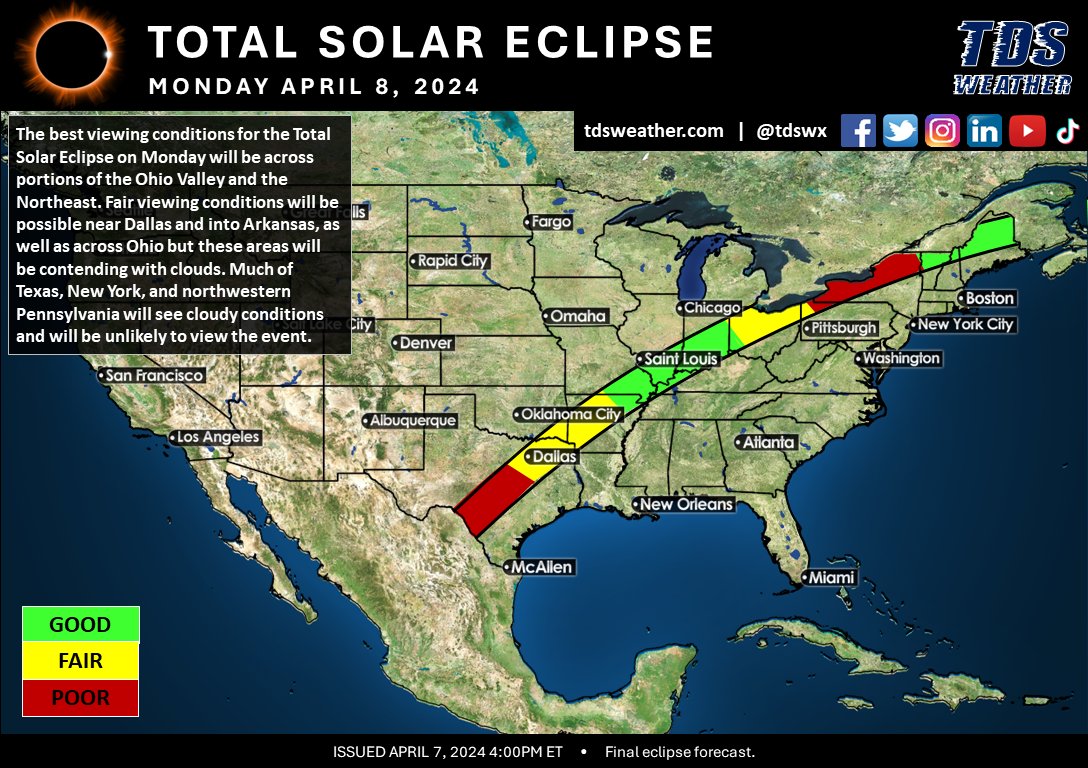
The highly-anticipated 2024 Total Solar Eclipse is finally upon us! Tomorrow, Monday April 8, 2024, fifteen U.S states will experience this once-in-a-lifetime event. The best places to view the eclipse based on the path of totality and expected weather conditions, plus tips for viewing this special event here: https://t.co/Q2QaRlWCr3
#TSE #TSE24 #TSE2024 #Eclipse #SolarEclipse #TotalSolarEclipse #weather #clouds #TXwx #ARwx #OKwx #TNwx #KYwx #MOwx #ILwx #INwx #OHwx #MIwx #NYwx #PAwx #VTwx #NHwx #MEwx
Would love to hear everyone’s stories. This event made me want to be a meteorologist. I saw the damage in Monticello at age 5 1/2 and still have memories. #INwx
Hi everyone! @IDHS is collecting stories and memories of the 1974 SuperOutbreak as part of a special 50th anniversary story map project. If you would like to contribute, please visit https://t.co/IViZqimi3d
#tornado#weather#SuperOutbreak#severewx
🚨Confidence is climbing for an impactful winter storm Monday night through Wednesday morning!🚨
The best chance for a swath of 6" or more snowfall currently looks to be across northern Missouri, eastern Iowa, stretching to Madison WI and Chicago IL, and into western and northern Michigan.
#INwx #ILwx #OHwx #MIwx #WIwx #MOwx #IAwx #snow #winter #weather #winterstorm
New video up!!
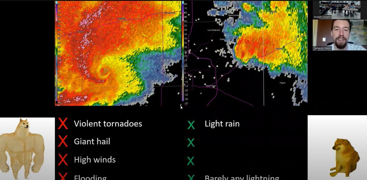
Geared for chasers; I share some tips and tricks for predicting mini-supercells, long-track tornadoes, and what a cell merger could do to your storm. Thank you @INChaserCon !!
https://t.co/pwdlvoaPUU