INNOVIM harnesses the power of science and technology to empower federal agencies to understand the world and create a brighter, safer future for our nation.
It would take more than nine years for light to travel the length of this pillar of gas and dust in the Eagle Nebula. Eventually the ultraviolet light from the offscreen stars that leave it silhouetted against the nebula will erode the pillar completely. Credit: Hubble/NASA, ESA.
Water vapor imagery is mesmerizing to watch, and today's view of the Pacific via @NOAA's #GOESWest 🛰️ is no exception. In this visualization, deep atmospheric moisture appears green/white, while drier air is depicted as yellow/orange. #FullDiskFriday
Learn more:
https://t.co/0bKRP1dHsf
JUST IN: Today, NOAA shared first images of the Western Hemisphere from NOAA's new GOES-19 satellite.
The satellite constantly views the same area of the planet, tracking weather conditions & hazards as they happen.
https://t.co/lKYmyJVMQP
@NOAASatellites
Summer 2023’s record-high water temperatures caused bleaching and coral death in Florida. In 2024, though global temperatures continued to break records, ocean temperatures in the Straits of Florida eased, buying restoration efforts some time. https://t.co/WJN3rzWt1k
This animation shows changes in vegetation across various regions in the Northern Hemisphere, including North America, captured by NOAA’s JPSS satellites from April to mid-September 2024.
See how the greenery subtly shifts as we approach the #AutumnEquinox. 🔎🌳
A cloud so unique it has a name ☁️
Rugged terrain near Middlemarch on New Zealand’s South Island gives rise to a distinctive, elongated lenticular cloud formation. Locally, the cloud is called “Taieri Pet.” https://t.co/Tf8sPGUWQy
🌀 #20YearsAgo on Sep 16: Hurricane Ivan slammed into Gulf Shores, Alabama. Destruction from Ivan claimed dozens of lives and caused billions of dollars in damage in the U.S. Due to the destruction Ivan wrought, the @WMO retired the name in 2005. https://t.co/6bfYpoDLCD
The aurora borealis casts a brilliant glowing streak across part of the Northern Hemisphere in this early morning image composite captured by the #VIIRS Day-Night band from NOAA’s JPSS satellites on September 17, 2024. ✨
Image credit: @NOAA/@CIRA_CSU
For 14 years, our custom Moon Maps have identified spectacular lunar sites to view each International #ObserveTheMoon Night.
New this year: an interactive, mobile-friendly version!
Click on each lunar feature for more information and close-ups: https://t.co/EZnX5fOK1Z
These images, captured by #VIIRS onboard the #NOAA21 satellite on Aug. 30 and Sept. 9, 2024, use enhanced color to highlight rain accumulation in the Sahara Desert.
Clouds are shown in light cyan, while water is dark blue to indicate moisture content.
Credit: @NOAA/@CIRA_CSU
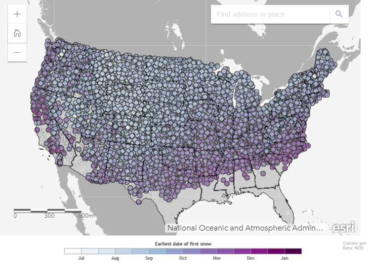
September is here, and many across the nation are dreaming of cooler weather and even snow. Check out this interactive map to find out the earliest date snow has fallen across thousands of U.S. stations. https://t.co/N16o0ILwPK
Alaska’s Columbia Glacier has lost more than half of its total thickness and volume since the 1980s. These images captured by #Landsat 8 reveal more recent changes, like how the main branch has retreated since 2019. https://t.co/0mj2abV2z8
Periods of G3 (Strong) geomagnetic storms are likely on 16 Sep 2024 due to coronal hole influences and the anticipated arrival of a CME associated with an X4.5 flare at 14/1529 UTC from AR3825.