Foundation for Ecological Security's technology arm was conceptualised to enable nature conservation and natural resource management through data and technology
After a successful pre-monsoon campaign, Napo Jal Bachao Kal (NJBK) returns on 15 October 2026 for its post-monsoon cycle of groundwater monitoring.
By measuring well water levels, communities, partners and organisations can better understand changes in groundwater availability, a resource that sustains livelihoods, livestock and agriculture. These local observations build the evidence needed for informed water management and community-led action.
Groundwater is part of our shared natural commons, and caring for it begins with understanding it.
Join the campaign this post-monsoon. One well at a time, we can build a clearer picture of India’s groundwater.
Learn more about the campaign here: https://t.co/EmMDGCqa0C
@IOforCommons
#NapoJalBachaoKal #GroundwaterMonitoring #NaturalCommons #CommunityAction #WaterSecurity #FoundationForEcologicalSecurity
🚨 Last Day to Register for #Code4Nature2026
Join developers, designers, GIS practitioners, researchers, students and environmental professionals to co-create solutions for nature.
⏳ Registration closes today
Register here: https://t.co/rugu6bQ7qv
Meaningful technology can drive better outcomes for nature, communities and local governance.
Code4Nature 2026 invites coders, developers, data enthusiasts, designers and innovators to build technology-driven solutions for nature conservation and ecological restoration.
Whether you are exploring geospatial technologies, data science or digital tools, bring your ideas to a challenge that connects technology with real-world environmental needs and enables community stewardship.
Registrations open on 01 August 2026. Stay tuned for the challenge statement, indicative themes and key dates.
#Code4Nature #TechForNature #NatureTech #DataForNature #DigitalInnovation #EcologicalRestoration #CommunityStewardship #Geospatial #OpenInnovation
Technology can help us understand landscapes better, strengthen local decision-making and support ecological restoration. But the best solutions begin with complex challenges on the ground.
Working in interdisciplinary teams, participants will develop solutions across themes including water security, biodiversity, climate resilience and community-based natural resource governance.
Registrations: 1-20 August 2026
Register here: https://t.co/XM6SKFzLXx
Meaningful technology can drive better outcomes for nature, communities and local governance.
Code4Nature 2026 invites coders, developers, data enthusiasts, designers and innovators to build technology-driven solutions for nature conservation and ecological restoration.
Whether you are exploring geospatial technologies, data science or digital tools, bring your ideas to a challenge that connects technology with real-world environmental needs and enables community stewardship.
Measure the water level in at least one well near you and record it using the Groundwater Monitoring Tool.
Mapping the same well every season helps build long-term insights into the groundwater trends in your area. Every observation contributes to a larger, community-driven understanding of how our water resources are changing over time.
Your participation is vital. The more people take part, the stronger our collective ability to understand local water realities, identify emerging challenges and support informed, sustainable governance. This is more than data collection; it is a shared effort towards our collective water security and resilience for our communities.
Download the GWM Tool here: https://t.co/O7B6UV1GGo
Share widely. Start measuring.
Let's collectively take efforts towards sustainable water governance.
@IOforCommons
#NapoJalBachaoKal #GroundwaterMonitoring #WaterCommons #PromiseOfCommons
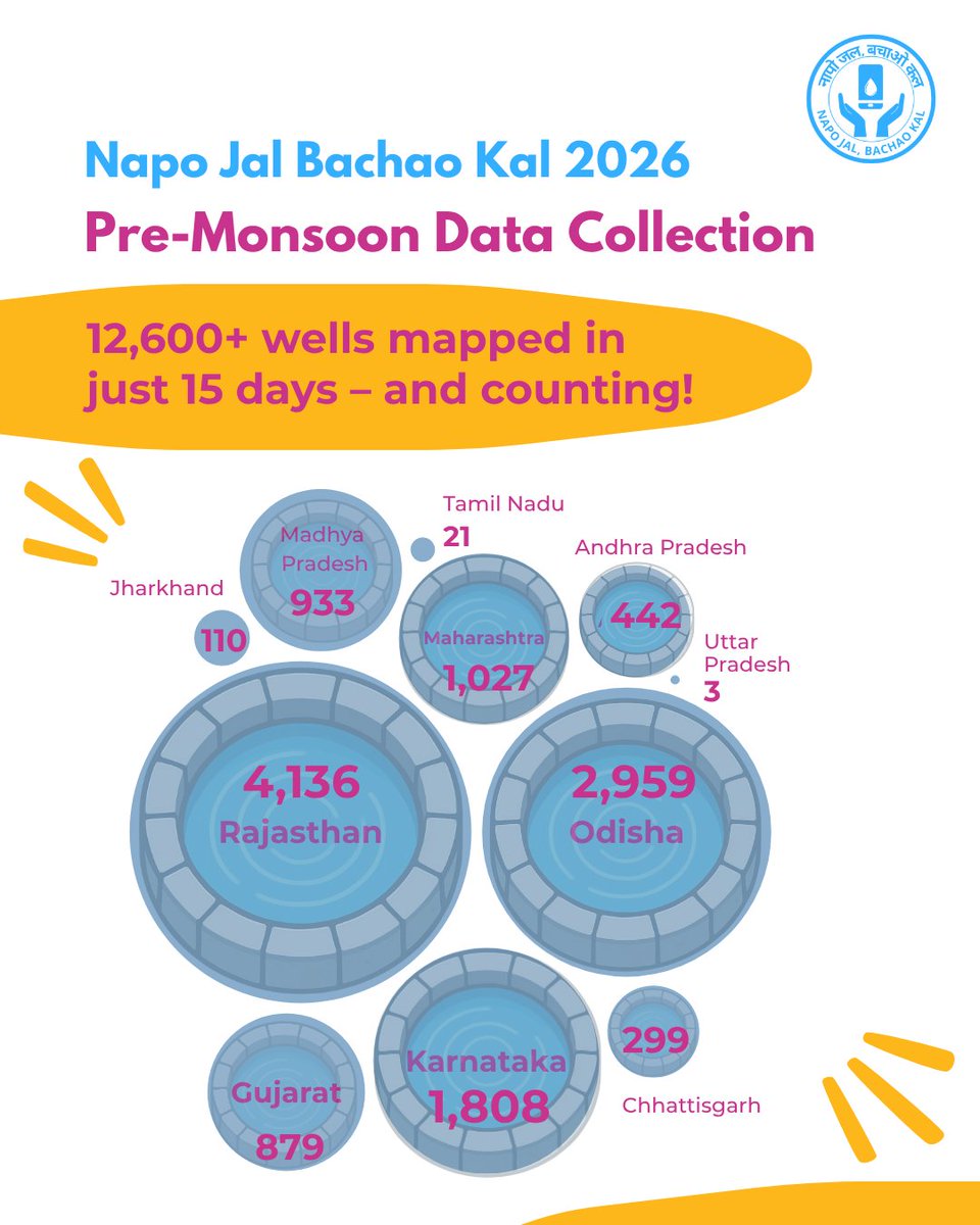
Over the last few weeks, people from hundreds of villages across the country have been measuring well water levels, engaging with their communities about the importance of mapping their water Commons and generating valuable data to deepen our collective understanding of groundwater trends across diverse landscapes.
Their encouraging participation in this year’s campaign has motivated us to extend this citizen science initiative until 30th June, giving more individuals and communities a chance to take part.
Watch this short video of a collection of experiences gathered from community members reflecting on how participating in this collective effort has helped them.
If you haven’t yet participated in this well water mapping exercise, this is your chance to join in on this effort and become a groundwater champion!
To know how to participate, check this easy-to-use guide in your preferred language: https://t.co/QmXx4w6aea
@IOforCommons
#NapoJalBachaoKal #GroundwaterMonitoring #WaterCommons #PromiseOfCommons
Across regions, communities are coming together to better understand groundwater and strengthen collective water stewardship through the Napo Jal Bachao Kal campaign.
Community members are monitoring well water levels before and after the monsoon, reflecting on changing groundwater conditions, and using this knowledge to plan for more sustainable water use and conservation.
This initiative highlights how local monitoring and collective participation can support informed decision-making on crop planning, groundwater management, water conservation, and long-term resilience.
These stories from the ground reflect a shared understanding: water conservation begins with awareness, observation, and collective action. Through their experiences, they encourage us all to participate in the campaign and join this collective effort towards water security.
Through community participation, local planning, and tools such as the Groundwater Monitoring Tool, villages are building pathways towards safer and more water-secure futures.
“Jal hai toh Kal hai.”
Join the pre-monsoon leg of the campaign between 15 May - 15 June 2026.
@IOforCommons
#NapoJalBachaoKal #WaterConservation #Groundwater #Commons #CollectiveStewardship #CommunityAction #WaterSecurity #ClimateResilience #PromiseOfCommons #MGNREGA
#GroundwaterMonitoring #WaterCommons #LocalAction
Use these guides, available in English, Hindi, Odia, Telugu, Marathi, Kannada, and Gujarati, to assist you through the well-water mapping process this #NapoJalBachaoKal Campaign Pre-Monsoon data collection.
Click here for more information on the campaign: https://t.co/miDcCu6PAu
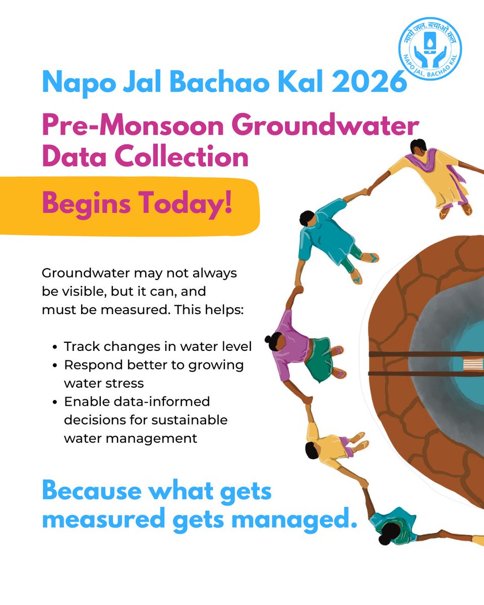
The #NapoJalBachaoKal Campaign 2026 begins today.
From May 15 to June 15, citizens, communities, students, and institutions across India will come together to measure groundwater levels in wells under this citizen science initiative. By measuring water levels in wells over time, we build a deeper, collective understanding of our groundwater systems.
Participating is simple.
Whether you’re a first-time user or working alongside your community, these easy guides help you collect well-water data with ease. These guides are available in 7 languages: Marathi, Gujarati, Odia, Kannada, Telugu, English and Hindi.
Click on the link, pick your language, and join the movement for a water-secure India. https://t.co/1OMQBinUrz
@IOforCommons
#NapoJalBachaoKal #GroundwaterMonitoring #WaterCommons #LocalAction #PromiseOfCommons
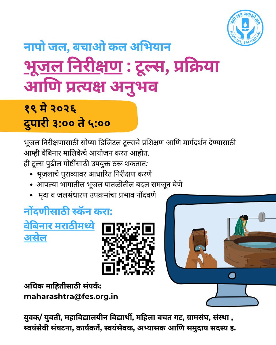
Join the nationwide movement for community-led groundwater governance through the Napo Jal Bachao Kal Campaign.Participate in the upcoming webinars on groundwater monitoring, data collection, and the use of GWMT to strengthen informed local action and sustainable water management
The Napo Jal Bachao Kal Campaign is a nationwide effort to build a decentralised, community-driven groundwater monitoring system by encouraging the monitoring of at least one well in every village across India.
As part of this initiative, two webinars are being organised on 19 May 2026 to build a common understanding of groundwater monitoring processes, data collection standards, and the use of the Groundwater Monitoring Tool (GWMT).
These webinars are designed to enable organisations, institutions, volunteers, practitioners, and community members to actively participate in the nationwide Pre-Monsoon Well Monitoring Campaign through a shared understanding of groundwater monitoring processes and tools.
Session 1 : 11:00 AM – 1:00 PM IST, An open webinar for all on groundwater monitoring processes, data collection standards, and the use of the Groundwater Monitoring Tool (GWMT). Register here: https://t.co/a9VtTWjo5I
Session 2 : 3:00 PM – 5:00 PM IST, A regional language webinar in Marathi to enable wider participation, local engagement, and discussions grounded in regional contexts and experiences. Register here: https://t.co/9iCOWLQFhw
By strengthening local groundwater evidence, the campaign seeks to enable better planning, informed decision-making, and collective action towards sustainable groundwater governance.
After all, “What gets measured, gets managed.”
@IOforCommons
#NapoJalBachaoKal #Groundwater #GWMT #WaterConservation #ClimateAction #WaterGovernance #PromiseofCommons
Groundwater may be invisible beneath our feet, but it determines how our landscapes survive and thrive.
Before the monsoon arrives and recharge begins, the pre-monsoon season gives us a vital opportunity to understand the true state of our groundwater.
This is where collective action matters.
The #NapoJalBachaoKal Campaign returns this pre-monsoon season, inviting citizens, communities, students, and institutions across India to join a nationwide citizen science effort to monitor groundwater levels in wells.
A single well measurement may seem small, but together, thousands of observations can help build a deeper understanding of our shared water systems and strengthen its stewardship.
Pre-monsoon Monitoring Cycle: 15 May – 15 June
Know more and participate: https://t.co/EmMDGCqa0C
@IOforCommons
#NapoJalBachaoKal #GroundwaterMonitoring #WaterCommons #PromiseOfCommons
We are pleased to share that Chiranjit Guha from FES will be speaking tomorrow, 1 May 2026, at the Geospatial Knowledge Infrastructure (GKI) Summit taking place during the Geospatial World Forum Conference & Tech Show 2026 in Amsterdam, Netherlands.
In his session, “Embedding GKI into Digital Public Infrastructure: Connecting Digital Systems to Physical Reality,” Chiranjit will discuss why Geospatial Knowledge Infrastructure (GKI) is a critical missing layer in Digital Public Infrastructure (DPI).
While DPI has largely focused on identity, payments, and exchange, GKI serves as the spatial operating system that enables digital systems to connect with the physical world. From geolocating beneficiaries in social protection systems to strengthening last-mile public health logistics and enabling digital addresses where formal street systems are incomplete, GKI can significantly improve the reach, efficiency, and equity of public systems.
Join the conversation as global experts explore how integrating geospatial intelligence into DPI can transform governance and public service delivery and why it should be a national priority.
@GeospatialM@IOforCommons
Learn more: https://t.co/dGY9XWor9J
#GWF2026 #GeospatialInfrastructure #PromiseOfCommons
We are pleased to share that Chiranjit Guha and Jay Patel from FES are participating in the Geospatial World Forum Conference & Tech Show 2026, taking place in Amsterdam, Netherlands, from 27 April 2026 to 1 May 2026.
We look forward to connecting with fellow delegates, exchanging insights, and contributing to the global dialogue on geospatial knowledge infrastructure.
Know more on the Geospatial World Forum Conference & Tech Show 2026: https://t.co/dGY9XWor9J
@IOforCommons@GeospatialM
#GWF2026 #GeospatialInfrastructure #PromiseOfCommons
The post-monsoon well monitoring exercise has been extended till 30th November, 2025!
If you haven’t started mapping your village/town’s wells yet, this is your chance.
Thank you to everyone who has already contributed!
With your support, water levels for thousands of wells across India are being recorded — helping communities take informed decisions to manage their groundwater.
The GWMT (Ground Water Monitoring Tool) app — version 3.5, available in 9 languages — makes it simple.