Indo-Pacific Tropical Cyclone Warning Center. Warning Agency issuing UNOFFICIAL forecasts for Tropical Cyclones in the North Indian Ocean and Northwest Pacific.
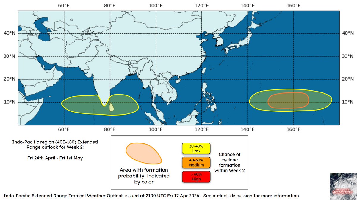
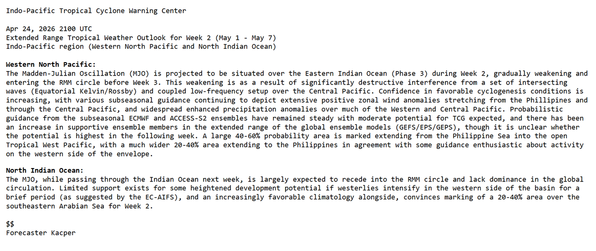
Indo-Pacific Extended Range Tropical Weather Outlook | May 1 - May 7, 2026: There is a 🟠 Medium (40-60%) chance of tropical cyclogenesis near Micronesia and Guam. There is a 🟡 Low (20-40%) chance of tropical cyclogenesis across the southeastern Arabian Sea.
IPTCWC TC Update
Severe Tropical Storm #Sinlaku Advisory #25
…SINLAKU TURNING POST TROPICAL, TRANSITION LIKELY TO BE COMPLETED TONIGHT…
Sat, Apr 18, 2026 1500 UTC
Location: 24.1°N 147.5°
Max Sustained Winds: 60 knots (70 mph)
Minimum Central Pressure: 978mb
Dvorak Analysis: FT 2.5 CI 3.0
Next full IPTCWC advisory: 04/15 00z
Indo-Pacific Extended Range Tropical Weather Outlook | Apr 24 - May 1, 2026: There is a 🟠 Medium (40-60%) chance of tropical cyclogenesis across the Open Tropical West Pacific. There is a 🟡 Low (20-40%) chance of tropical cyclogenesis across the Arabian Sea and Bay of Bengal.
Typhoon #Sinlaku Advisory #24: Sinlaku still a typhoon, expected to begin post tropical transition in around 24 hours. Max winds have decreased to 75knots (85mph). Typhoon warnings remain in effect for #Alamagan, #Pagan, #Agrihan. Transition to cold core storm force low expected to begin in around 24 hours. See @NWSGuam for official info. Click below for more.
Typhoon #Sinlaku Advisory #23: Sinlaku entering cooler waters. Typhoon warnings remain in effect for Alamagan, Pagan and Agrihan. Max winds have decreased to 85 knots (100mph). Watches and warnings for Guam, Saipan and Tinian have been cancelled, see @NWSGuam for further information. Click below for more info.
Typhoon #Sinlaku Advisory #22: Sinlaku on a weakening trend, forecast to become post tropical in around 72 hours. Max winds have decreased to 95knots (110mph). Tropical storm conditions still occurring over #Tinian and #Saipan, expected to subside in 12-24 hours. Transition to cold core storm force low by Tau 72 as system interacts with the subtropical jet. See @NWSGuam for official info. Click below for more.
Typhoon #Sinlaku Advisory #21: Sinlaku still a major typhoon, impacts beginning to subside on Tinian and Saipan. Max winds are at 110knots (125mph). Typhoon warnings remain in effect for all of Marianas Islands except #Guam. Weakening trend forecasted with transition to a cold core post tropical low in around 96 hours. See @NWSGuam for official info. Click below for more.
IPTCWC will release seasonal predictions for the 2026 Western North Pacific and 2026 North Indian Ocean tropical cyclone seasons, on April 28, 2026.
The delayed release of these predictions are to ensure their quality while we produce them in a new, more extended format.
Typhoon #Sinlaku Advisory #20: Large Sinlaku to the west of the Mariana Islands. Persistent heavy rainfall, strong winds, and significant storm surge to continue through the next few days. Max winds are at 115 knots (130mph). Typhoon warnings remain in effect for #Rota, #Tinian, #Saipan, #Alamagan, #Pagan, #Agrihan. See @NWSGuam for official information. Click below for more information.
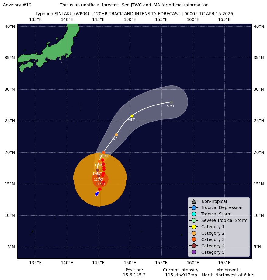
Typhoon #Sinlaku Advisory #19: Sinlaku slowly pulling away from Saipan, strong wind gusts still affecting Tinian and Saipan. Max winds have decreased to 115knots (130mph). Typhoon warnings remain in effect for #Rota, #Tinian, #Saipan, #Alamagan, #Pagan, #Agrihan. Conditions to subside in Marianas Islands after 24-36 hours. See @NWSGuam for official information. Click below for more.
IPTCWC TC Update
Super Typhoon #Sinlaku Intermediate Advisory #17A
…SINLAKU STILL LASHING TINIAN AND SAIPAN…
Tue, Apr 14, 2026 1500 UTC
Location: 15.1°N 145.6°E
Max Sustained Winds: 120knots (140mph)
Minimum Central Pressure: 914mb
Dvorak Analysis: FT 6.0 CI 6.5
Next IPTCWC advisory: 04/14 18z
Typhoon #SINLAKU Advisory #17: Sinkalu making landfall over Saipan. Mad winds have decreased to 120knots (140mph). Destructive winds, life threatening storm surge occurring. 113knot wind gusts reported in Saipan. Typhoon warnings remain in place for #Rota, #Tinian and #Saipan. Re-strengtheing possible next 24 hours. Post Tropical transition to begin after 72 hours. See @NWSGuam for official info. Click below for more.